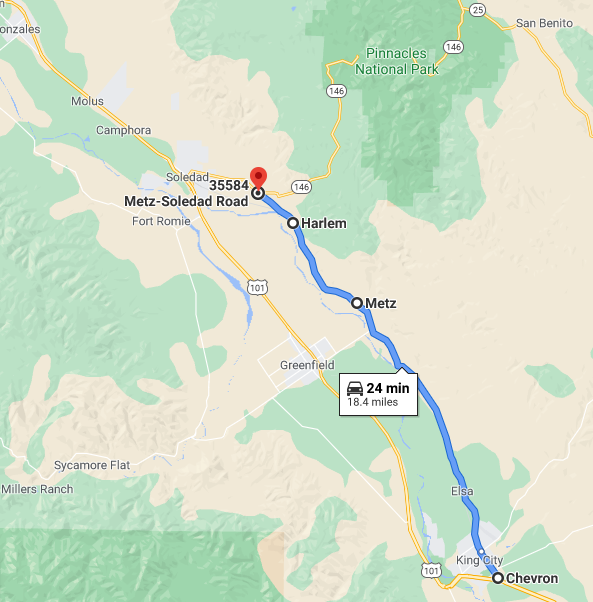
One of the more unique ways to get to the western annex of Pinnacles National Park requires an alternate route to US Route 101 via Sign County Route G15. Sign County Route G15 rides the edge of the Gabilan Range above Salinas Valley and provides a view of the 1923 Metz Tunnel.

Sign County Route G15 ("G15") is a 18.68 mile highway located entirely within Monterey County. G15 begins at US Route 101 ("US 101") in King City and travels north along the westernmost flank of the Gabilan Range just above Salinas Valley to California State Route 146 ("CA 146"). As noted above G15 provides a view of the 1923 Metz Tunnel and incorporates some of the original alignment of US 101 in King City. The approximate routing of G15 can be seen below.
Part 1; the history of Sign County Route G15
According to CAhighways.org what is now G15 was first defined in 1965. At the time of G15's commissioning US 101 was still active on 1st Street and Broadway within downtown King City. Sign County Route G13 was also defined in 1965 alongside G15. It is likely G15 originated at G13/Bitterwater Road on the outskirts of King City and simply used Metz Road to reach CA 146. G15 is heavily tied to the Salinas Valley routing of the Southern Pacific Railroad (now Union Pacific Railroad). Within much of Salinas Valley the Southern Pacific Railroad was constructed during the 1880s along the western edge of the Gabilan Range which was in an opportune high grade above the flood prone Salinas River.
King City is a small City in Salinas Valley of southern Monterey
County. King City had been settled in 1884 after Charles King acquired
13,000 acres of land from what was Rancho San Lorenzo. King City was
originally known as Hog Town and was plotted as a large ranching
community. By 1886 King City had a stop on the Southern Pacific
Railroad and Post Office Service began in 1887. The Post Office adopted
the name "King City" and the community began to grow approaching the
start of the 20th Century. King City became large enough that the
Southern Pacific Railroad constructed a large depot in 1903 which was
located near the intersection of 1st Street and Broadway Street. The
1903 Southern Pacific Railroad Depot is now on display at San Lorenzo
Park near the banks of the Salinas River. The 1903 Southern Pacific
Railroad Depot would have been one of the early landmarks on US 101
within in King City.


In addition to King City the community of Chalone was settled to the north along the Southern Pacific Railroad and future corridor of G15 in 1886. Chalone would be renamed to Metz in 1888 when the community first obtained Post Office Service. Metz derived it's name from it's first Post Mater W.H.H. Metz. King City and Metz (shown as Cholone) can be seen on the 1890 George F. Cram Railroad & County Map of California. Coburn is shown as a siding located between King City and Metz.

The era of State Highway Maintenance through King City would
ultimately begin with the 1909 First State Highway Bond Act which was
approved by voters in 1910. One of the highways approved through the
1909 First State Highway Bond Act was a 481.8 mile highway originating
at the City Limits of San Francisco which terminated in San Diego. This
highway would ultimately come to be known in time as Legislative Route
Number 2 ("LRN 2").
Unlike the Spanish El Camino Real which was aligned west of the Salinas
River to stay on path to Mission San Antonio de Padua and Mission
Nuestra Senora de la Soledad the path of LRN 2 was aligned mostly
through the center of Salinas Valley. The route of LRN 2 also differed from the Southern Pacific Railroad in Salinas Valley which was mostly aligned east of the Salinas River. The planned alignment of LRN 2
was much more direct than the path to the Missions which made the
crossing over the Salinas River at King City vital to State interests.
At some point in 1914 the existing wooden highway bridge over the
Salinas River in King City was destroyed in a flood and was replaced in
1919. Until the 1919 Salinas River Bridge was completed traffic headed
south from Salinas to King City likely would had utilized Metz Road. A
photo of this wooden bridge over the Salinas River can be found on bridgehunter.


The last California Highways & Public Works to reference the US 101 King City bypass was in the November/December issue. Said issue states that the King City bypass had been advanced to the 1966-67 Fiscal Year.

Upon the completion of the King City bypass route of US 101 the former surface route in downtown King City was added to G13 and G15. 1st Street became an extension of G15 whereas G13 was extended over Broadway Street. The original alignment of US 101/LRN 2 can be seen on the sketch below.

Part 2; a drive on Sign County Route G15
Today modern US 101 northbound Exit 281 approaching King City accesses
it's former surface alignment on 1st Street. 1st Street is surprisingly
well signed as G15 and even carries a reassurance shield directing traffic en route to G13. US 101 Business is signed from northbound US 101
but isn't well signed within King City on 1st Street.


The first major intersection of G15 northbound on 1st Street is 0.20 miles in at Lonoak Road.

G15 northbound enters downtown King City and meets G13 at 1st Street and Broadway. G13 southbound follows Old US 101 on Broadway westward towards modern US 101 whereas 1st Street carries a multiplex of G15/G13 northbound.

G15/G13 northbound follow 1st Street as it transitions to Bitterwater Road and crosses the Union Pacific Railroad. G13 continues north on Bitterwater Road towards CA 25 and the eastern annex of Pinnacles National Park. G15 turns left and heads north on Metz Road towards the west annex of Pinnacles National Park.


G15 follows Metz Road north which climbs above the Union Pacific Railroad and the Salinas River. G15 passes through what was once the siding of Coburn. Coburn was named by the Southern Pacific after a land owner by the name of Loren Coburn which granted an easement through his property in 1883.
G15 northbound follows Metz Road and climbs over the 1923 Metz Tunnel. As noted above the 1923 Metz Tunnel is an obvious feature which can be seen from the G15. The original Southern Pacific grade can be seen at the bottom of the hill left of the 1923 Metz Tunnel.


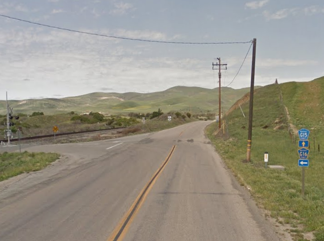
G15 north on Metz Road intersects Sign County Route G16 at Elm Avenue.

North of Elm Avenue G15/Metz Road continues to follow the eastern flank of the Union Pacific Railroad. G15 passes through what was once the siding community of Metz. Metz was located on Metz Road near the mouth of Saucito Canyon but no longer exists. Metz reportedly had Post Office Service until 1913. G15 reaches a north terminus at CA 146, the latter which is signed as 9 miles from Pinnacles National Park.

Comments