
Hawaii Route 311


Hawaii Route 311 is a 6.4-mile State Highway located on the Island of Maui.  Hawaii Route 311 connects the communities of Kahului and Kihei via a four-lane expressway grade.  Hawaii Route 311 traditionally was known as Mokulele Highway and now designated as Maui Veterans Highway.


Part 1; the history of Hawaii Route 311

The Island of Maui seemingly was not part of the original World War II era Hawaii Route System.  Circa 1955 the United States Bureau of Public Roads renumbered the Hawaii Route System.  The 1955 Hawaii Route Renumbering saw most of the conventions utilized by the current Hawaii State Route System established.  Primary Hawaii Routes were given two-digit numbers whereas Secondary Hawaii Routes were given three-digit numbers.  The Hawaii Routes were assigned in sequence for what Island/County they were located on coupled with what Federal Aid Program number they were tied to.  In the case of the Island of Maui it was assigned numbers in the range of 30-40.  

Hawaii Route 35 was originally designated as having a northern terminus in Kahului at Hawaii Route 32/Kaahumanu Avenue.  From Kahului, Hawaii Route 35 followed Puunene Avenue south to the Alexander & Baldwin company town of Puunene.  From Puunene, Hawaii Route 35 followed Mokulele Highway south to Kihei and Hawaii Route 31 at Kihei Road.  Hawaii Route 35 as originally configured can be seen on the 1959 Gousha Map of Hawaii.  Hawaii Route 35 is noted to be a secondary highway.  

During the 1960s the Hawaii Route System was simplified, and numerous important roads added to the State's inventory.  According to hawaiihighways.com the entirety of Hawaii Route 35 was originally maintained by Maui County.  During the 1960s all of what was Hawaii Route 35 was added to the State's inventory and reassigned as Hawaii Route 350.  At some point (the timeframe is unclear) Hawaii 350 seems to have been truncated to existing only on Puunene Avenue.  From Puunene Avenue the entirety of Mokelule Highway was transferred to a newly designated Hawaii Route 311.  

During May 2008 an expansion of Mokulele to a divided four-lane highway was completed between Hawaii Route 31/Piilani Highway and Hawaii Route 380/Kuihelani Highway.  The expansion of Hawaii Route 311 extended north of Puunene via a bypass.  The segment of Hawaii Route 350 in Puunene was partially abandoned and the highway was truncated to Hawaii Routes 311 and 380 at Kuihelani Highway.  It isn't clear but appears this is when Hawaii Route 350 was truncated it was also redesignated as Hawaii Route 3500.  During April 2017 Hawaii Route 311 was designated as Maui Veterans Highway by Governor David Ige.


Part 2; a drive on Hawaii Route 311

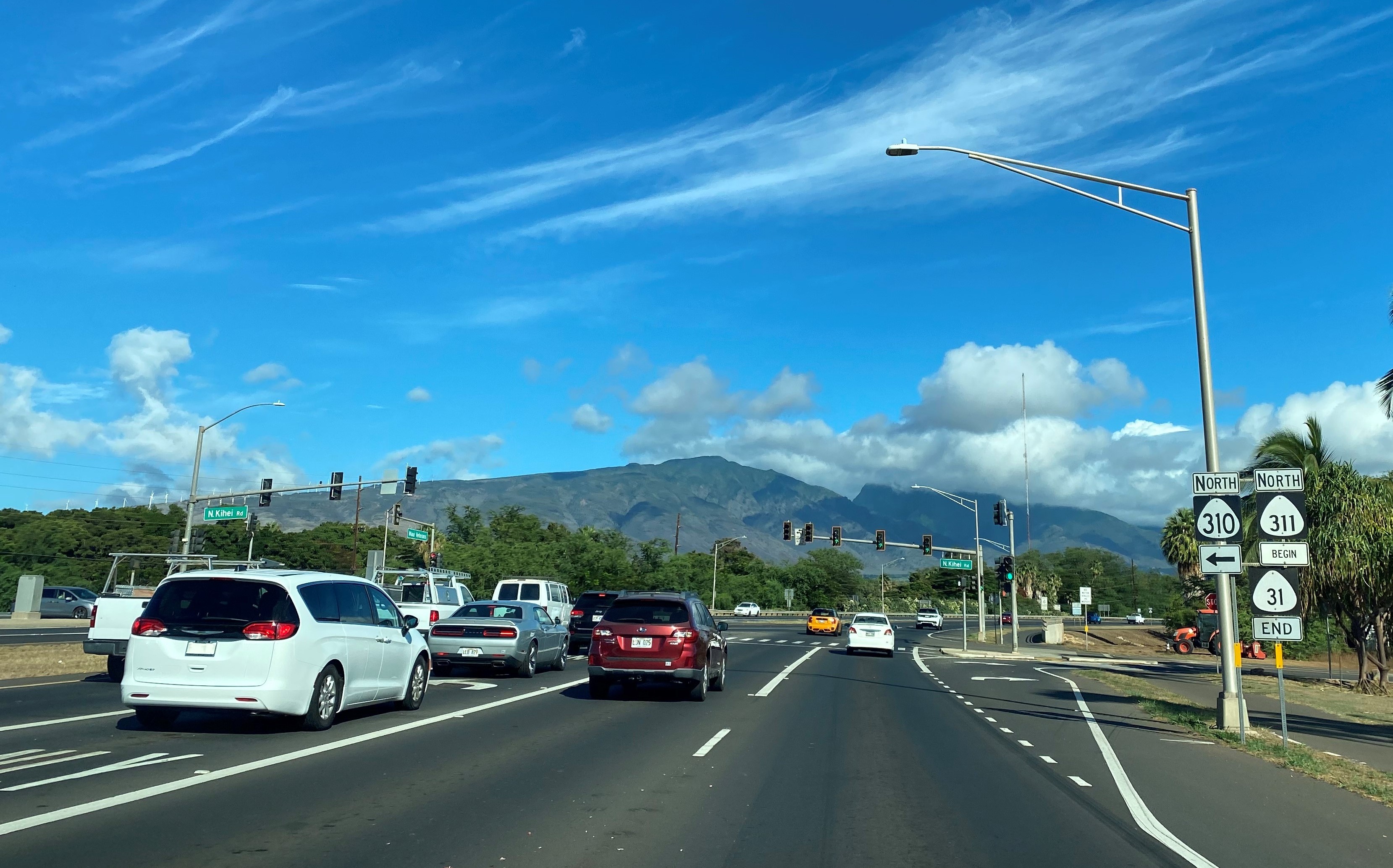
Hawaii Route 311 northbound begins at the north terminus of Hawaii Route 31/Piilani Highway at the outskirts of Kihei.  From the northbound start of Hawaii Route 311 a guide sign denotes Kahului as being 7 miles away.  


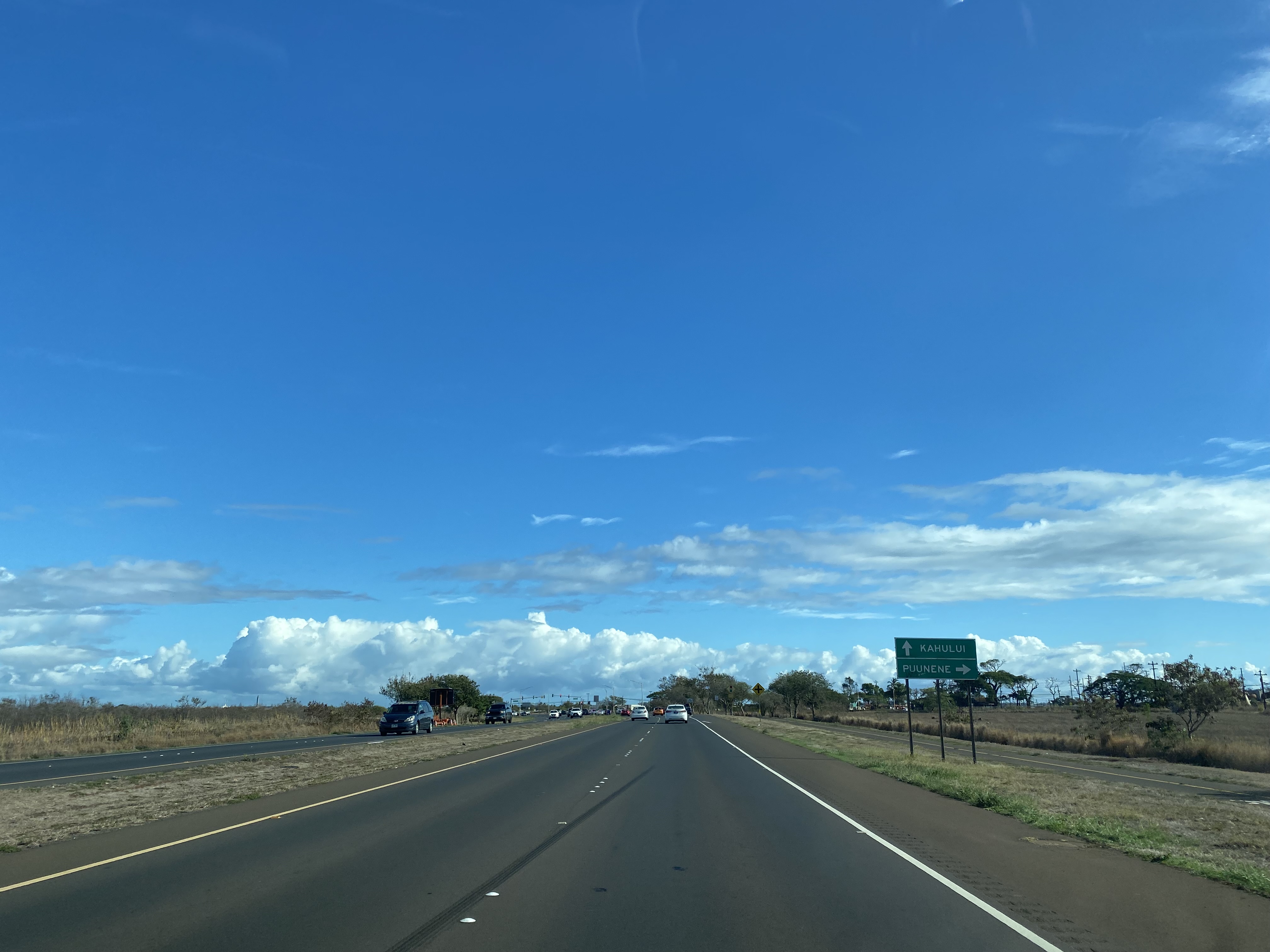
Hawaii Route 311 northbound follows Maui Veterans Highway north towards Kahului.  Hawaii Route 311 traffic can access Puunene from Hansen Road.  


Hawaii Route 311 northbound terminates at the junction of Hawaii Routes 380, 3800 and 3500 in Kahului.  


 Part 3; former Hawaii Route 311 on Old Mokulele Highway in Puunene

Former Hawaii Route 35/350 on Old Puunene Avenue and former Hawaii Route 311 on Old Mokulele Highway can still be accessed.  North of Hansen Road the former alignment of Hawaii Route 35/350 on Old Puunene Avenue is abandoned.  

Below the soft transition from former Hawaii Route 350 south on Old Puunene Avenue to former Hawaii Route 311 on Old Mokulele Highway can be seen.  The junction is still easily identifiable due to the weathered Hawaii Route 311 shield still directing traffic onto Old Mokulele Highway.  


Below is a series of photos of the company town site of Puunene from Old Puunene Avenue.  Puunene was plotted around the Hawaii Commerical & Sugar Company Mill (a division of Alexander & Baldwin) which was completed during 1901.  The Hawaiian Commercial & Sugar Company Mill closed during 2016 which ended production of sugar cane on the Hawaiian Islands.  


Comments

Popular posts from this blog

Paper Highways: The Unbuilt New Orleans Bypass (Proposed I-410)

  There are many examples around the United States of proposed freeway corridors in urban areas that never saw the light of day for one reason or another. They all fall somewhere in between the little-known and the infamous and from the mundane to the spectacular. One of the more obscure and interesting examples of such a project is the short-lived idea to construct a southern beltway for the New Orleans metropolitan area in the 1960s and 70s. Greater New Orleans and its surrounding area grew rapidly in the years after World War II, as suburban sprawl encroached on the historically rural downriver parishes around the city. In response to the development of the region’s Westbank and the emergence of communities in St. Charles and St. John the Baptist Parishes as viable suburban communities during this period, regional planners began to consider concepts for new infrastructure projects to serve this growing population.  The idea for a circular freeway around the southern perimeter of t

Hernando de Soto Bridge (Memphis, TN)

The newest of the bridges that span the lower Mississippi River at Memphis, the Hernando de Soto Bridge was completed in 1973 and carries Interstate 40 between downtown Memphis and West Memphis, AR. The bridge’s signature M-shaped superstructure makes it an instantly recognizable landmark in the city and one of the most visually unique bridges on the Mississippi River. As early as 1953, Memphis city planners recommended the construction of a second highway bridge across the Mississippi River to connect the city with West Memphis, AR. The Memphis & Arkansas Bridge had been completed only four years earlier a couple miles downriver from downtown, however it was expected that long-term growth in the metro area would warrant the construction of an additional bridge, the fourth crossing of the Mississippi River to be built at Memphis, in the not-too-distant future. Unlike the previous three Mississippi River bridges to be built the city, the location chosen for this bridge was about two

Memphis & Arkansas Bridge (Memphis, TN)

  Like the expansion of the railroads the previous century, the modernization of the country’s highway infrastructure in the early and mid 20th Century required the construction of new landmark bridges along the lower Mississippi River (and nation-wide for that matter) that would facilitate the expected growth in overall traffic demand in ensuing decades. While this new movement had been anticipated to some extent in the Memphis area with the design of the Harahan Bridge, neither it nor its neighbor the older Frisco Bridge were capable of accommodating the sharp rise in the popularity and demand of the automobile as a mode of cross-river transportation during the Great Depression. As was the case 30 years prior, the solution in the 1940s was to construct a new bridge in the same general location as its predecessors, only this time the bridge would be the first built exclusively for vehicle traffic. This bridge, the Memphis & Arkansas Bridge, was completed in 1949 and was the third