US Route 66 was formally approved by the American Association of State Highway officials to be extended from Los Angeles to Santa Monica in June 1935. At the time US Route 66 had an interim terminus at US Route 101 Alternate located at the end of Santa Monica Boulevard at Ocean Avenue. In 1936 the more recognizable terminus of US Route 66 in Santa Monica at Lincoln Boulevard and Olympic Boulevard was established upon the opening of the McClure Tunnel.
Before being officially extended in 1935, the city of Santa Monica did about everything it possibly could to get US Route 66 extended into its boundaries. These attempts went as far as paying the Auto Club of Southern California to sign US Route 66 through Los Angeles all the way to Ocean Avenue via Santa Monica Boulevard from December 1930-January 1931. The rogue signage of US Roure 66 into Santa Monica is one of the most bizarre stories in the history US Route system and an example of how a city not taking "no" for an answer actually paid off.
Featured as the blog cover is an article headline from the January 27, 1931, Santa Monica Outlook which announced US Route 66 had been signed through Santa Monica. Below the western terminus of US Route 66 can be seen relocated to Lincoln Boulevard and Olympic Boulevard on the 1936-37 Division of Highways Map.
Part 1; the history of the western terminus of US Route 66 in Santa Monica
The earliest route description of US Route 66 (US 66) by the American Association of State Highway Officials (AASHO) has the highway technically ending in San Fernando. The AASHO approved the creation of the US Route System on November 11, 1926.
Note: the responsibility of designating and approving movements of the US Routes has always been under the scope of AASHO (and modern AASHTO). The early history of the western terminus of US 66 has numerous parties and factors contributing to its movements which fall outside of the supervision of the AASHO. This blog has far more conjecture than I would like but it is clear that a great deal of movement was at foot with US 66 around Los Angeles without AASHO approval. My recommendation would be to always follow the official definitions of US Routes provided by the AASHO. Nonetheless, this blog will attempt to examine all angles to the narrative of the early western terminus of US 66.
Notably, the original terminus of US 66 within Los Angeles is generally cited to have been located at 7th Street and Broadway. 7th Street and Broadway is the known terminus of the Los Angeles branch of the National Old Trails Road (NOTR).
In April of 1912, the NOTR was organized with the goal of signing a transcontinental highway between Baltimore and Los Angeles. Building a modern road for automotive use through the Mojave Desert of California would prove to be particularly difficult as State Highway Maintenance didn't exist, and the general path of travel was alongside the service routes of railroads. The first Auto-Trail through Cajon Pass was the Santa Fe-Grand Canyon Needles National Highway which was first signed in Cajon Pass by 1913. NOTR organizers later adopted the routing of the Santa Fe-Grand Canyon Needles National Highway in the western United States by 1914. The NOTR was able to secure funding to pave the route through Cajon Pass and construct the 1914 Crowder Canyon Bridge. The construction of the NOTR through Cajon Pass provided direct automobile access to the Inland Empire and Los Angeles Basin.
FHWA.dot.gov National Old Trails RoadThe location of the western terminus of US 66 was a source of much contention during the establishing years of the US Route System. In a letter dated March 1, 1927, California State Highway Engineer R.M. Morton replied to AASHO Executive Secretary W.C. Markham conveying it was the understanding of the California Highway Commission that US 66 ended in San Fernando.
In a letter dated April 21, 1927, California State Highway Engineer R.M. Morton writes to AASHO Executive Secretary W.C. Markham regarding numerous US Route topics. The western terminus of US 66 in San Fernando, how US 66 did not touch the City Limits of Los Angeles, and the omission of Pasadena from the US 66 Route Description are expounded upon. Notably, R.M. Morton states the description of US 99 would have it jog south into Los Angeles and then follow a multiplex of US 66 east to San Bernardino.


On April 26, 1927, AASHO Executive Secretary W.C. Markham wrote in a letter to California Highway Commission Office Engineer L.T. Cambell stating it would be preferable to have US 66 end somewhere in Los Angeles. W.C. Markham noted US 66 was already being promoted as the primary highway between Chicago and Los Angeles. W.C. Markham goes on to suggest that it would be helpful if signage of the western terminus of US 66 was placed in the nearest convenient location within the City of Los Angeles. The terminus of US 66 in San Fernando is described as a technical error and that the last city on the Route Description should be Los Angeles.
Thusly US 66 is displayed in the
January 1928 California Highways & Public Works as terminating in Los Angeles via San Fernando. This seems to imply US 66 was to be signed somewhere via multiplex of US 99 on San Fernando Road into the City Limits of Los Angeles.
Note, prior to 1933 the Division of Highways was not actively involved in maintaining urban highways outside of occasional cooperative projects. The responsibility for signage of US Routes in cities was thusly given to the ACSC in the Southern California region.
In the early US Route era amid the confusion as to the location of US 66 in Los Angeles, the city of Santa Monica is shown to have desired to extend the highway into its boundaries. In the
May 31, 1928, Santa Monica Outlook (courtesy MapMikey) an article notes the city of Santa Monica was planning to send delegates to the June 6, 1928, US Route 66 Association convention Flagstaff in an attempt to secure the western terminus of the highway.


The
June 18, 1929, Santa Monica Outlook (courtesy MapMikey) announced Los Angeles intended to aid the city of Santa Monica in signing US 66 to their boundaries. The Los Angeles city engineer John C. Shaw was directed by the Los Angeles City Council to cooperate with extending US 66 to Santa Monica. US 66 is noted in the article to be currently signed to the western terminus at the Los Angeles/Pasadena city limit at the western edge of the Colorado Street Bridge. A planned routing for US 66 through Los Angeles to Santa Monica is described as following Pasadena Avenue, York Boulevard, Eagle Rock Boulevard, Fletcher Drive, Glendale Boulevard, Rowena Avenue, Hyperion Avenue, Fountain Avenue, and Myra Avenue. No planned terminus for US 66 in Santa Monica is cited in the article.


The 1930 Division of Highways Map notably seems to follow the AASHO description of US 66 given in the January 1928 California Highways & Public Works. US 66 is shown terminating at US 99 near San Fernando which would have barely skirted the City of Los Angeles.
The
Los Angeles City Council meeting notes (courtesy MapMikey) from February 5, 1930, explicitly state that the US Routes were not yet signed within Los Angeles. The Los Angeles City Council did elect to have the ACSC sign US 99 and US 101 during the February 5, 1930, meeting but not US 66. The rationale by the Los Angeles City Council for not having the ACSC sign US 66 was due to the uncertainty of the location of the highway.
The Los Angeles City Council Minutes on January 12, 1931, provides context to the initial signing of US 66 through Los Angeles. In 1930 the City of Santa Monica petitioned the Los Angeles City Council to have the ACSC sign US 66 through Los Angeles to their city limit at their expense. The Los Angeles City Council approved the request to allow the ACSC to sign US 66 to Santa Monica on December 15th, 1930. The Los Angeles City Council notably did not petition the California Highway Commission or AASHO regarding the signing of US 66 to Santa Monica.
The ACSC signage of US 66 within the City of Los Angeles is stated to have begun on Colorado Boulevard at the Los Angeles/Pasadena City Lines. US 66 is stated to follow Colorado Boulevard, Eagle Rock Boulevard (formerly Glassell Avenue), and Fletcher Drive to US 99 at San Fernando Road. US 66 is stated to continue westward via Glendale Boulevard, Rowana Boulevard, Hyperion Avenue, Myra Avenue, the viaduct under Sunset Boulevard, and Santa Monica Boulevard to the city of Santa Monica. The Los Angeles City Council Minutes do not describe where US 66 was signed to in Santa Monica.
Note: Fletcher Drive was completed between Eagle Rock Boulevard and San Fernando Road which can be seen in announced in a
January 26, 1929 newspaper.
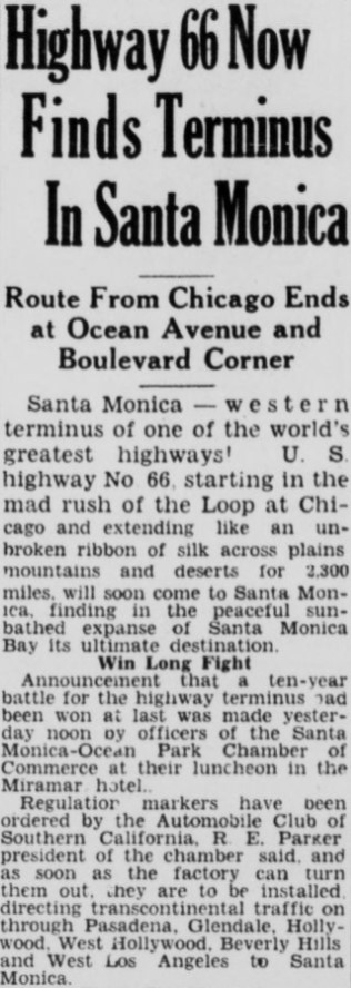
The
January 27, 1931, Santa Monica Outlook (courtesy MapMikey) announced US 66 had been signed through Santa Monica. The article details the alignment of US 66 in Santa Monica as following Santa Monica Boulevard to a terminus at Ocean Avenue.
The AASHTO Database file for 1931 shows a letter dated April 7th which illustrates the California Highway Commission and AASHO had become aware of US 66 being signed through Los Angeles to Santa Monica. California State Highway Engineer C.H. Purcell acknowledges in a response letter to the AASHO Executive Secretary that the US 66 signage in Santa Monica was not officially approved by the AASHO and had been placed by the ACSC at the behest of the City of Los Angeles and Los Angeles County. C.H. Purcell notes the ACSC had agreed to withdraw US 66 signage from the city limit of Santa Monica. No officially established western terminus of US 66 is discussed in the exchange of letters.
The May 19, 1931, Santa Monica Outlook (courtesy MapMikey) announced the removal of the US 66 signs in Santa Monica. The article stub notes the dissatisfaction of the Santa Monica City Council in having the signage of US 66 withdrawn by State orders to Los Angeles.
The November 6, 1931, Santa Monica Outlook (courtesy MapMikey) announced Edgar Knight of the US 66 Grand Canyon-Boulevard Dam Highway Association met with the Santa Monica Chamber of Commerce to discuss promoting Santa Monica as the western terminus of US 66.
Below is an exchange of letters dated to November/December 1931 between C.H. Purcell the California State Highway Engineer and W.C. Markham Executive Secretary of the AASHO. Markham conveys a desire to split US 66 into a mainline routing terminating at US 101 in downtown Los Angeles at Sunset Boulevard via Broadway and an Alternate Route which bypassed downtown towards US 101 at Sunset Boulevard via Hyperion Avenue. The AASHO recommended extending US 66 to Santa Monica so that the Mainline and Alternate Route would have a meet-up point via US 101.
Ultimately Markham appears to have been not in favor of having US 66 ending in Santa Monica whereas the AASHO didn't want dual terminus points. Of note, the documents below show US 66 signage had been retracted by the ACSC from Santa Monica to a terminus point at US 99/San Fernando Road via Fletcher Drive. Despite US 66 being signed to an endpoint at San Fernando Drive via Fletcher Drive, there seemingly was never an approval to make it the official terminus by the AASHO Executive Committee. It is not clear when the signage of US 66 shifted from a signed terminus at San Fernando Road and Fletcher Drive.
The first three Figueroa Street Tunnels opened between Riverside Drive and Solano Avenue in October of 1931 which routed traffic through Elysian Park. The Figueroa Street Tunnels would ultimately end up becoming a key piece of the future Arroyo Seco Parkway and resolving an official terminus of US 66 in Los Angeles.
1933 was a landmark year in terms of Statewide transportation. The State Legislature removed restrictions that prevented State Funds from being used to maintain urban roadways. This change by the Legislature led to the addition of numerous urban highways.
California Highways Highway Chronology Chapter 3; A Significant System is Created 1933-1946One of the 1933 additions to the State Highway system was Legislative Route Number 165 (LRN 165) which was routed from San Pedro to La Canada via Figueroa Street. The addition of LRN 165 made the three completed Figueroa Street Tunnels part of the State Highway system and led to the construction of the fourth southernmost tunnel. Figueroa Street once completed between Pasadena and downtown Los Angeles would serve as a much more direct corridor with more traffic capacity than earlier NOTR.
CAhighways.org on LRN 165Another 1933 addition to the State Highway System was what had been signed as US 66 on Santa Monica Boulevard as part of
LRN 162. The original definition of LRN 162 was "LRN 60 at Santa Monica to Colorado Boulevard near Eagle Rock." LRN 162 can be seen for the first time on the
1934 Division of Highways Map. LRN 162 can be seen ending at the interim alignment of LRN 60 at Santa Monica Boulevard and Lincoln Boulevard.


Much of the early US Route system around Los Angeles was heavily altered after 1933. During 1934 US 99 was realigned off a multiplex of US 66 from Pasadena-San Bernardino (LRN 9) to a new alignment which took it to Redlands via downtown Los Angeles, Pomona, and Colton on LRN 26. The attached sketch map implies US 66 was aligned through the Figueroa Street Tunnels, Solano Avenue, and Broadway to a terminus at US 101/Sunset Boulevard.
CAhighways.org has a page dedicated to I-110/CA 110 which shows a photo of the fourth Figueroa Street Tunnel under construction. Temporary signage showing US 66/US 99 and California State Route 11 can be seen in front of the tunnel which is looking southbound. The Temporary signage shows US 99/US 66 and California State Route 11 (CA 11) jogging from the fourth Figueroa Street Tunnel onto Solano Street onwards to Broadway. Note: CA 11 was one of the initial Sign State Routes announced in the August 1934 California Highways & Public Works.
On June 14, 1935, the California State Highway Engineer submitted a request to extend US 66 from the intersection of Broadway and Sunset Boulevard in Los Angeles to the intersection of Lincoln Boulevard and Pennsylvania Avenue in Santa Monica.
The California State Highway Engineer acknowledges in a letter dated to July 6, 1935, that the AASHO Executive Committee had approved the extension of US 66 to Santa Monica. The California State Highway Engineer conveyed a desire to delay the announcement of the extension of US 66 until US 6 had been extended to Long Beach. It is unclear why the approval of US 6 to California would impact the announcement of the extension of US 66 to Santa Monica.

Amusingly the Santa Monica Chamber of Commerce had already announced the formal extension of US 66 which can be seen in the
July 2, 1935, Santa Monica Outlook. The article stub notes US 66 was to be extended back to Ocean Avenue via Santa Monica Boulevard to an interim terminus. The article notes the change of CA 3 on Roosevelt Highway to US 101A as being critical in making the extension of US 66 to Santa Monica Official.
The interim terminus of US 66 via LRN 162 to Ocean Avenue in Santa Monica was necessary due to the incomplete new tunnel alignment which would carry US 101A/LRN 60 through Palisades Bluff. Work on the Palisades Bluff tunnel on US 101A/LRN 60 is featured in the
July 1935 California Highways & Public Works.
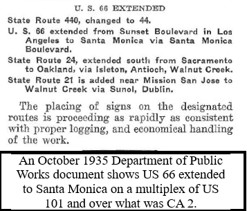
The October 1935 California Highways & Public Works announced US 66 was extended to US 101A in Santa Monica via LRN 162. The extension of US 66 to Santa Monica truncated CA 2 to Hyperion Avenue along LRN 162.
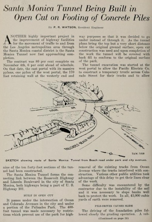
An update to the progress of the now so-called Santa Monica Tunnel appears in the
November 1935 California Highways & Public Works. The Santa Monica Tunnel is noted to be a component of the new alignment of US 101A /LRN 60 between Ocean Avenue and Lincoln Boulevard. The Santa Monica Tunnel is noted to be 80% complete as of November 4, 1935.


The
February 1936 California Highways & Public Works announced the opening of the Santa Monica Tunnel as the new alignment of US 101A/LRN 60 between Ocean Avenue and Lincoln Boulevard. The Santa Monica Tunnel is stated to have opened to traffic on February 1, 1936. The Santa Monica Tunnel was renamed the "McClure Tunnel" in 1979.
The opening of the Santa Monica Tunnel and realignment of US 101A/LRN 60 rendered the interim alignment of US 66 at Ocean Avenue via Santa Monica Boulevard obsolete. The terminus of US 66 can be seen following LRN 162 to US 101A/LRN 60 at the intersection of Lincoln Boulevard and Olympic Boulevard on t
he 1936-37 Division of Highways Map.
The 1949-1957 era variation of the US 66 END sign at the corner of Lincoln Boulevard and Olympic can be seen in the undated
AAroads Shield Gallery photo below.
US 66 was approved to be truncated from Santa Monica to US 95 in Needles by the AASHO on November 14, 1963, in the run-up to the 1964 State Highway Renumbering. US 66 was effectively immediately removed from Santa Monica, Los Angeles, and the Pasadena Freeway (formerly and once again the Arroyo Seco Parkway) with signage being truncated to Pasadena. This measure left only CA 11 as the only signed highway on the Pasadena Freeway. Signage of US 66 would not be truncated from Pasadena to US 95 until I-40 was completed through the Bristol Mountains in 1972.
Below US 66 can be seen beginning at US 101A in Santa Monica in a Caltrans stock photo (courtesy of usends.com
US Route 66 endpoints page).
The 1964 State Highway Renumbering extended CA 2 west of the Hollywood Freeway over Santa Monica Boulevard and Lincoln Boulevard to what was now CA 1 in Santa Monica. CA 2 west of the Hollywood Freeway replacing US 66 to Santa Monica can be seen on the
1964 Division of Highways Map.
CA 2 within the city limits of Santa Monica would be deleted from the State Highway System by way of 1998 Legislative Chapter 877. The origin point of CA 2 was changed to "near Santa Monica" by Chapter 877. CA 2 appears truncated out of Santa Monica on the 2005 Caltrans Map.
Part 2; the endpoints of US Route 66 in Santa Monica visualized
Below Google Street View image is on Santa Monica Boulevard westbound at Ocean Avenue. This would have been signed as the endpoint of US Route 66 from December 1930-January 1931 and likely for short time during 1935 before the opening of the Santa Monica Tunnel.
The below image shows the 1936-1963 western terminus of US 66 at Lincoln Boulevard at Olympic Boulevard. A historic US Route 66 END sign can be seen above the Olympic street blade.
Part 3; Santa Monica Pier
Santa Monica Pier is about a block west of the 1936 terminus of US 66 via Colorado Avenue and bears incorrect signage boasting that it was the endpoint. The signage on Santa Monica Pier is largely considered to be ceremonial given it is located at the Pacific Ocean.
Santa Monica Pier opened on September 9, 1909. Santa Monica Pier despite never actually being part of US 66 is primarily considered a landmark of the highway.
Sources & Links:


Comments