
Former US Route 101 through Soledad

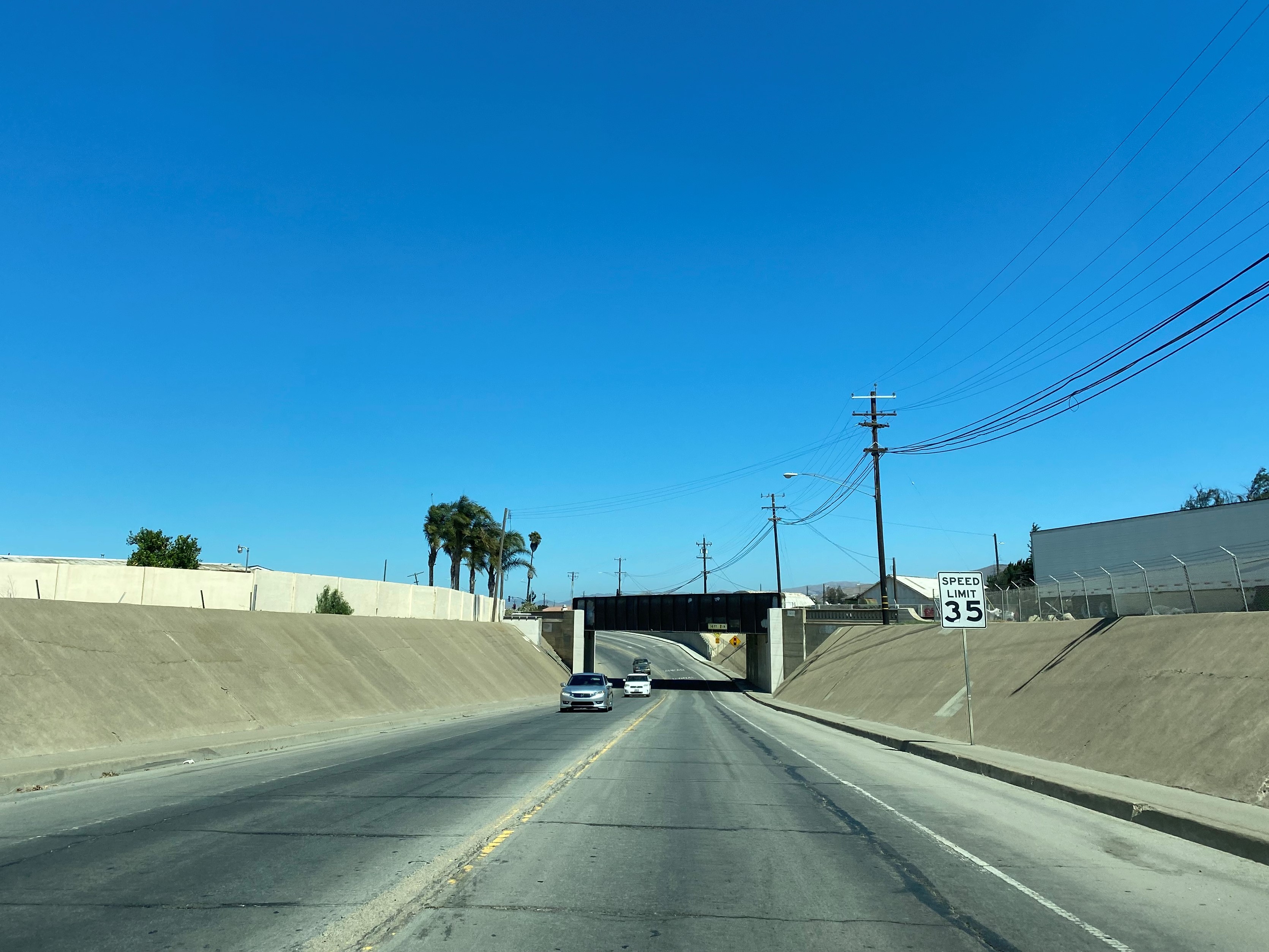
Soledad is a city located on the Salinas River of Monterey County which is presently bypassed by the freeway alignment of US Route 101.  US Route 101 originally entered Soledad northbound over the Salinas River via Nestles Road and Front Street.  US Route 101 was realigned onto an extension of Front Street via an underpass of the Southern Pacific Railroad during 1936.  The freeway alignment of US Route 101 in Soledad opened in 1960 and much of the former surface alignment became part of the western segment of California State Route 146 in 1964.  Pictured as the blog cover above is US Route 101 on Front Street as depicted in the July/August 1958 California Highways & Public Works.  US Route 101 appears below on Nestles Road and Front Street on the 1935 Division of Highways Map of Monterey County.  


Part 1; the history of US Route 101 in Soledad

Soledad traces its origin to the establishment of the Catholic Mission of Nuestra Señora de la Soledad on October 9, 1791, in Salinas Valley of Las Californias.  Mission Nuestra Señora de la Soledad unlike the modern community of Soledad was located on the western bank of the Salinas River.  Mission Nuestra Señora de la Soledad was the thirteenth Spanish Mission in Las Californias and would be an important way point on the road known as El Camino Real.  

The route of El Camino Real was intended to solidify a path of travel between the Catholic Missions of Las Californias.  In 1804 Alta California was formed out of the larger Las Californias.  El Camino Real would ultimately connect twenty-one Catholic Missions of Alta California ranging approximately 600 miles spanning from Mission San Diego de Alcala in San Diego north to Mission San Francisco Solano in Sonoma.

During August 1833 in period of Mexican Alta California the Spanish Missions were secularized.   The secularization of the Spanish Missions gradually led to most of their lands being granted as Ranchos.  Mission Nuestra Señora de la Soledad was granted to Estaban and Catalina Munrás as Rancho San Vicente during 1835 by Alta California Governor Jose Castro.  

Despite usage of the name "El Camino Real" declining following the secularization of the Spanish Missions the communities centered around them remained important destinations.  Thusly travel along the former path of Spanish El Camino Real remained a favored corridor of overland travel through the Mexican American War and emergence of the American State of California.  

Following the conclusion of the Mexican American War the land holdings granted by the Mexican Government were honored by the American Government.  California would ultimately become an American State on September 9, 1850, based on the fortunes of the Gold Rush in the Sierra Nevada Mountains.  Estaban Munrás died during 1850 which led to Rancho San Vicente passing into the sole ownership of his wife Catalina.  Mission Soledad can be seen as a major waypoint west of the Salinas River on the coastal highway to the Monterey Peninsula on the 1857 Britton & Rey's Map of California.  


During the 1860s Catalina Munrás began to subdivide and donate land east of the Salinas River to establish the town site of Soledad.  The Soledad Post Office would open during 1869 and Catalina Munrás would donate right-of-way to the Southern Pacific Railroad during 1872 to construct a line through the community.  Soledad for several years was the southern terminus of the coastal line of the Southern Pacific Railroad which led to an economic boom based off agriculture.  Monterey County would formally create the Township of Soledad on February 6, 1876.  Soledad can be seen as the southern terminus of the coastal line of the Southern Pacific Railroad on the 1882 Bancroft's Map of California and Nevada.  


Salinas Valley was ultimately part of the American El Camino Real which began being signed as an Auto Trail starting in 1906.  The era of State Highway Maintenance through Salinas Valley would ultimately begin with the 1909 First State Highway Bond Act which was approved by voters in 1910.  One of the highways approved through the 1909 First State Highway Bond Act was a 481.8-mile highway originating at the City Limits of San Francisco which terminated in San Diego.  This highway would ultimately come to be known in time as Legislative Route Number 2 ("LRN 2").  Within Salinas Valley much of LRN 2 would follow the existing corridor along the frontage roads of the Southern Pacific Railroad which included the community of Soledad.  

The July 1914 California Highway Bulletin notes surveys for the location of LRN 2 from Greenfield to Camphora via Soledad were complete.  

Greenfield can be seen on the 1917 California State Automobile Association Map along LRN 2.  LRN 2 is displayed to be aligned on what is now Nestles Road to an at-grade crossing of the Southern Pacific Railroad and Front Street.    


The 1920 Rand McNally Highway Map of California shows El Camino Real and the Pacific Highway following LRN 2 through Soledad.  Soledad would incorporate as a city on March 9, 1921. 


The 1924 Rand McNally Map of California shows the California Banff Bee-Line Highway co-signed with the Pacific Highway through Soledad. 


The July 1924 California Highways & Public Works noted gravel shoulders were being added to LRN 2 between Soledad and King City.  


The initial draft of the US Route System was approved by the Secretary of Agriculture during November of 1925.  The US Route System within California was approved by California Highway Commission with no changes recommended by January 1926.  The initial alignment of US Route 101 ("US 101") was planned to follow LRN 2 from San Francisco to San Diego via Salinas Valley.  US 101 is shown on a map published in the 1926 California Highways & Public Works following LRN 2 south from San Francisco towards San Diego.


During November of 1926 the US Route System was approved by the ASSHO.  US Route 101 can be seen aligned through Soledad on the 1926 Rand McNally Junior Map of California.  US Route 101 inherited the existing alignment of LRN 2 through Soledad via Nestles Road and Front Street.  


The July 1927 California Highways & Public Works announced the Salinas River Bridge along US Route 101/LRN 2 at Soledad had recently been reinforced.  


The January 1932 California Highways & Public Works announced a railroad grade separation was to be advertised for constructed along US Route 101/LRN 2 in Soledad.  The grade separation project zone included a 1.2-mile realignment of US Route 101/LRN 2 in Soledad.  


US Route 101/LRN 2 appears on Nestles Road and Front Street on the 1935 Division of Highways Map of Monterey County.  


The Soledad railroad subway on US Route 101/LRN 2 is listed as a project recommended for construction in the October 1935 California Highways & Public Works.  


The January 1936 California Highways & Public Works announced a contract to construct the railroad Subway in Soledad had been awarded.  


The September 1936 California Highways & Public Works lists the Soledad Underpass as having an anticipated opening on September 1, 1936.  The opening of the Salinas Underpass included a new alignment for US Route 101/LRN 2 on a southern extension of Front Street to the Salinas River Bridge. 


The January 1937 California Highway & Public Works listed a replacement span over the Salinas River along US Route 101/LRN 2 in Soledad as being budged for the 89th-90th Fiscal Years.  


The March 1937 California Highways & Public Works features an article regarding a new edge cutting surfacing device which was first tested when US Route 101/LRN 2 was repaved between Soledad-Gonzales during 1936.  


The September 1937 California Highways & Public Works announced an awarded contract to construct the new Salinas River Bridge in Soledad.  


The November 1938 California Highways & Public Works featured the opening of the new Salinas River Bridge along US Route 101/LRN 2 in Soledad.  The new Salinas River Bridge is cited in the article as having opened on October 23, 1938.  The previously Salinas River Bridge in Soledad is noted to have been constructed during 1914 for a previous timber span.  The 1914 Salinas River Bridge is noted to have been heavily damaged by a truck crash in 1934 and by a fire during 1935.  


The history of Mission Soledad is featured in the September/October 1945 California Highways & Public Works.  


The November/December 1956 California Highways & Public Works announced the widening of US Route 101/LRN 2 to four-lane expressway standards from 1.8 miles north of the Salinas River to 2 miles south of Greenfield as being budgeted for the 1957-58 Fiscal Year.  A second expressway project is listed as beginning 1 mile north of Greenfield to the Salinas River near Soledad.  


The May/June 1957 California Highways & Public Works notes the expressway expansion of US Route 101/LRN 2 between Greenfield and Soledad was underway.  The expressway expansion of US Route 101/LRN 2 between Greenfield and King City is noted to have been completed the previous February.  

The November/December 1957 California Highways & Public Works US Route 101/LRN 2 between Soledad and Gonzales was budgeted to be converted to four lane expressway standards.


The July/August 1958 California Highways & Public Works features the completed US Route 101/LRN 2 expressway between Greenfield and Soledad.  The article expounds on the details of the upcoming project zone of the Soledad freeway bypass.  The Soledad freeway bypass is stated to be a 2.8-mile corridor which was still in the design phases.  A second Salinas River Bridge is cited to be part of the planned Soledad freeway bypass.  


The September/October 1958 California Highways & Public Works noted the contractor responsible for converting US Route 101/LRN 2 to expressway standards in the Gonzales-Soledad corridor was given 275 days to complete the project.  Part of the expressway conversion between Gonzales-Soledad was construction of an interchanges at Camphora-Gloria Road and Soledad Medium Security State Prison. 


The September/October 1959 California Highways & Public Works notes the conversion of US Route 101/LRN 2 to four lane expressway standards between Soledad-Gonzales was expected to be complete by November.  


The November/December 1960 California Highways & Public Works notes the US Route 101/LRN 2 freeway bypass of Soledad had opened earlier in the year.  Much of former US Route 101 on Front Street in Soledad had been retained as an extension of LRN 120 which provided a State Highway connection to the western annex of Pinnacles National Monument.  


The March/April 1961 California Highways & Public Works features the newly opened freeway bypass alignment of US Route 101/LRN 2 in Soledad.  


During the 1964 State Highway Renumbering the Legislative Route Numbers were dropped in favor of Sign State Route designations.  Former US Route 101 on Front Street was redesignated from LRN 120 to part of the western segment of California State Route 146.  California State Route 146 appears for the first time on Front Street in Soledad on the 1964 Division of Highways Map.  


Part 2; exploring former US Route 101 on the surface streets of Soledad

As noted in Part 1 the original at-grade overpass US Route 101 took over the Southern Pacific Railroad was on Nestles Road.  Below vintage Portland Cement can still be observed as Nestles Road terminates at the modern Union Pacific Railroad where US Route 101 once crossed to Front Street.  


From modern US Route 101 northbound upon crossing the Salinas River traffic can access the former surface alignment via Exit 302 onto California State Route 146/Front Street.  


California State Route 146 follows Front Street northbound through the 1936 Underpass into downtown Soledad. 


California State Route 146 continues on Front Street northward to East Street where it splits eastward towards Pinnacles National Park.  


Former US Route 101 on Front Street between East Street to Benito Street through downtown Soledad has been narrowed to permit additional parking.  


From Benito Street northward the grade of Front Street widens again and loops back to the freeway grade of US Route 101. 


Comments

Popular posts from this blog

Paper Highways: The Unbuilt New Orleans Bypass (Proposed I-410)

  There are many examples around the United States of proposed freeway corridors in urban areas that never saw the light of day for one reason or another. They all fall somewhere in between the little-known and the infamous and from the mundane to the spectacular. One of the more obscure and interesting examples of such a project is the short-lived idea to construct a southern beltway for the New Orleans metropolitan area in the 1960s and 70s. Greater New Orleans and its surrounding area grew rapidly in the years after World War II, as suburban sprawl encroached on the historically rural downriver parishes around the city. In response to the development of the region’s Westbank and the emergence of communities in St. Charles and St. John the Baptist Parishes as viable suburban communities during this period, regional planners began to consider concepts for new infrastructure projects to serve this growing population.  The idea for a circular freeway around the southern perimeter of t

Hernando de Soto Bridge (Memphis, TN)

The newest of the bridges that span the lower Mississippi River at Memphis, the Hernando de Soto Bridge was completed in 1973 and carries Interstate 40 between downtown Memphis and West Memphis, AR. The bridge’s signature M-shaped superstructure makes it an instantly recognizable landmark in the city and one of the most visually unique bridges on the Mississippi River. As early as 1953, Memphis city planners recommended the construction of a second highway bridge across the Mississippi River to connect the city with West Memphis, AR. The Memphis & Arkansas Bridge had been completed only four years earlier a couple miles downriver from downtown, however it was expected that long-term growth in the metro area would warrant the construction of an additional bridge, the fourth crossing of the Mississippi River to be built at Memphis, in the not-too-distant future. Unlike the previous three Mississippi River bridges to be built the city, the location chosen for this bridge was about two

Huey P. Long Bridge (New Orleans, LA)

Located on the lower Mississippi River a few miles west of New Orleans, the Huey P. Long Bridge is an enormous steel truss bridge that carries both road and rail traffic on an old-time structure that is a fascinating example of a bridge that has evolved in recent years to meet the traffic and safety demands of modern times. While officially located in suburban Jefferson Parish near the unincorporated community of Bridge City, this bridge’s location is most often associated with New Orleans, given that it’s the largest and most recognizable incorporated population center in the nearby vicinity. For this reason, this blog article considers the bridge’s location to be in New Orleans, even though this isn’t 100% geographically correct. Completed in 1935 as the first bridge across the Mississippi River in Louisiana and the first to be built in the New Orleans area, this bridge is one of two bridges on the Mississippi named for Huey P. Long, a Louisiana politician who served as the 40th Gove