Former California State Route 248 was a small post-1964 State Highway Renumbering designation of a segment of US Route 66 and early US Route 99 from Pasadena east to Monrovia. Specifically, California State Route 248 originated at California State Route 134 and terminated at Interstate 210 following the Colorado Street Bridge, Colorado Boulevard, Colorado Place, and Huntington Boulevard. Much of California State Route 248 was signed as US Route 66 until 1972 and was gradually relinquished between 1986-1992. Pictured above as the blog cover is the Colorado Street Bridge which was once part of US Route 66, US Route 66 Alternate, and California State Route 248 from 1964-1986.

Part 1; the history of California State Route 248
Part of what would become California State Route 248 would be added to the State Highway System during the 1909 State Highway Bond Act via would become Legislative Route Number (LRN 9). The 1909 First State Highway Bond Act which was ultimately approved by voters in 1910. The majority of the highways approved as part of the First State Highway Bond Act were largely well-established routes such as the corridor between San Fernando east to San Bernardino. At the time of the 1909 First State Highway Bond Act, the State of California could not maintain highways within the boundaries of incorporated cities which left a gap LRN 9 through Pasadena.
In April of 1912, the National Old Trails Road (NOTR) was organized with the goal of signing a transcontinental highway between Baltimore and Los Angeles. Building a modern road for automotive use through the Mojave Desert of California would prove to be particularly difficult as State Highway Maintenance didn't exist, and the general path of travel was alongside the service routes of railroads. The first Auto-Trail through Cajon Pass was the Santa Fe-Grand Canyon Needles National Highway which was first signed in Cajon Pass by 1913. NOTR organizers later adopted the routing of the Santa Fe-Grand Canyon Needles National Highway in the western United States by 1914. The NOTR was able to secure funding to pave the route through Cajon Pass and construct the 1914 Crowder Canyon Bridge.
FHWA.dot.gov National Old Trails Road
From San Bernardino beginning at Mount Vernon Avenue/4th Street, the NOTR followed existing LRN 9 westbound to Pasadena. Upon reaching Pasadena the NOTR branched away from LRN 9. The NOTR westbound jogged south on Santa Anita Avenue to Colorado Boulevard in Pasadena and departed towards Los Angeles via Fair Oaks Avenue. The NOTR followed Fair Oaks Avenue, Huntington Drive, and Broadway into downtown Los Angeles where it terminated at the intersection of Broadway and 7th Street. The early NOTR can be seen on the 1916 National Old Trails Road map below.
The NOTR and National Park-to-Park Highway can be seen following LRN 9 from San Bernardino to Pasadena on the 1924 Rand McNally Map of California. Both highways are shown splitting from LRN 9 in Pasadena towards downtown Los Angeles.
The initial draft of the US Route System was approved by the Secretary of Agriculture in November of 1925. The US Route System within California was approved by California Highway Commission ("CHC") with no changes recommended which can be seen in January 1926 California Highways & Public Works. US Route 99 is given a vague description which had it multiplexed with US Route 60 (not yet US Route 66) from Los Angeles to San Bernardino via LRN 9 east from Pasadena.


Thusly planned US Route 99 and US Route 60 appear on the 1925 Rand McNally Map of California. Both US Route 99 and US Route 60 are shown diverging from LRN 9 towards downtown Los Angeles. The divergence of US Route 99 and US Route 60 from State Maintained LRN 9 is likely due to Los Angeles being used as a control point in both of their route descriptions.
The US Route System was formally approved by the American Association of State Highway Engineers (AASHO) on November 11th, 1926. The AASHO route description of US Route 99 states it was to follow LRN 4 over the Ridge Route from Bakersfield into Los Angeles. From Los Angeles, US Route 99 is only described as having a next route point in San Bernardino. From the initial route description of US Route 99, it is unclear where it began to multiplex US Route 66. US Route 66 is described as following LRN 9 from San Bernardino west to San Fernando by way of Pasadena where it would have terminated.
The location of the western terminus of US Route 66 was a source of much contention during the establishing years of the US Route System. In a letter dated March 1st, 1927, California State Highway Engineer R.M. Morton replied to AASHO Executive Secretary W.C. Markham conveying it was the understanding of the California Highway Commission that US Route 66 ended in San Fernando.
In a letter dated April 21st, 1927, California State Highway Engineer R.M. Morton writes to AASHO Executive Secretary W.C. Markham regarding numerous US Route topics. The western terminus of US Route 66 in San Fernando, how US Route 66 did not touch the City Limits of Los Angeles, and the omission of Pasadena from the US Route 66 Route Description are expounded upon. Notably, R.M. Morton states the description of US Route 99 would have it jog south into Los Angeles and then follow a multiplex of US Route 66 east to San Bernardino.


On April 26th, 1927, AASHO Executive Secretary W.C. Markham wrote in a letter to California Highway Commission Office Engineer L.T. Cambell stating it would be preferable to have US Route 66 end somewhere in Los Angeles. W.C. Markham noted US Route 66 was already being promoted as the primary highway between Chicago and Los Angeles. W.C. Markham goes on to suggest that it would be helpful if signage of the western terminus of US Route 66 was placed in the nearest convenient location within the City of Los Angeles. The terminus of US Route 66 in San Fernando is described as a technical error and the last city on the Route Description should be Los Angeles.


Thusly US Route 66 is displayed in the
January 1928 California Highways & Public Works as terminating in Los Angeles via San Fernando. This seems to imply US Route 66 was to be signed somewhere via multiplex of US Route 99 on San Fernando Road into the City Limits of Los Angeles. This routing would seem to infer it was the intent of the Division of Highways to sign US Route 66 west of Pasadena to San Fernando via LRN 9.


The
June 18th, 1929, Santa Monica Outlook (courtesy MapMikey) announced Los Angeles intended to aid the city of Santa Monica in signing US Route 66 to their boundaries. The Los Angeles city engineer John C. Shaw was directed by the Los Angeles City Council to cooperate with extending US Route 66 to Santa Monica. US Route 66 is noted in the article to be currently signed to the western terminus at the Los Angeles/Pasadena city limit at the western edge of the Colorado Street Bridge. A planned routing for US Route 66 through Los Angeles to Santa Monica is described as following Pasadena Avenue, York Boulevard, Eagle Rock Boulevard, Fletcher Drive, Glendale Boulevard, Rowena Avenue, Hyperion Avenue, Fountain Avenue, and Myra Avenue. No planned terminus for US Route 66 in Santa Monica is cited in the article.
The
Los Angeles City Council meeting notes (courtesy MapMikey) from February 5th, 1930, explicitly state that the US Routes were not yet signed within Los Angeles. The Los Angeles City Council did elect to have the ACSC sign US Route 99 and US Route 101 during the February 5th, 1930, meeting but not US 66. The rationale by the Los Angeles City Council for not having the ACSC sign US Route 66 was due to the uncertainty of the location of the highway.
The Los Angeles City Council Minutes on January 12th, 1931, provides context to the initial signing of US Route 66 through Los Angeles. In 1930, the City of Santa Monica petitioned the Los Angeles City Council to have the ACSC sign US Route 66 through Los Angeles to their city limit at their expense. The Los Angeles City Council approved the request to allow the ACSC to sign US Route 66 to Santa Monica on December 15th, 1930. The Los Angeles City Council notably did not petition the California Highway Commission or AASHO regarding the signing of US Route 66 to Santa Monica.
The ACSC signage of US 66 within the City of Los Angeles is stated to have begun on Colorado Boulevard at the Los Angeles/Pasadena City Lines via the non-state-maintained Colorado Street Bridge. US Route 66 is stated to follow Colorado Boulevard, Eagle Rock Boulevard (formerly Glassell Avenue), and Fletcher Drive to US Route 99 at San Fernando Road. US Route 66 is stated to continue westward via Glendale Boulevard, Rowana Boulevard, Hyperion Avenue, Myra Avenue, the viaduct under Sunset Boulevard, and Santa Monica Boulevard to the city of Santa Monica. The Los Angeles City Council Minutes do not describe where US Route 66 was signed in Santa Monica.


The AASHTO Database file for 1931 shows a letter dated April 7th which illustrates the California Highway Commission and AASHO had become aware of US 66 being signed through Los Angeles to Santa Monica. California State Highway Engineer C.H. Purcell acknowledges in a response letter to the AASHO Executive Secretary that the US 66 signage in Santa Monica was not officially approved by the AASHO and had been placed by the ACSC at the behest of the City of Los Angeles and Los Angeles County. C.H. Purcell notes the ACSC had agreed to withdraw US Route 66 signage from the city limit of Santa Monica. No officially established western terminus of US Route 66 is discussed in the exchange of letters.
Below is an exchange of letters dated to November/December 1931 between C.H. Purcell the California State Highway Engineer and W.C. Markham Executive Secretary of the AASHO. Markham conveys a desire to split US Route 66 into a mainline routing terminating at US Route 101 in downtown Los Angeles at Sunset Boulevard via Broadway and an Alternate Route which bypassed downtown towards US 101 at Sunset Boulevard via Hyperion Avenue. The AASHO recommended extending US Route 66 to Santa Monica so that the Mainline and Alternate Route would have a meet-up point via US Route 101.
Ultimately Markham appears to have been not in favor of having US Route 66 ending in Santa Monica whereas the AASHO didn't want dual terminus points. Of note, the documents below show US Route 66 signage had been retracted by the ACSC from Santa Monica to a terminus point at US Route 99/San Fernando Road via Fletcher Drive. Despite US Route 66 being signed to an endpoint at San Fernando Drive via Fletcher Drive there seemingly was never approval to make it the official terminus by the AASHO Executive Committee. It is not clear when the signage of US Route 66 was shifted from a signed terminus at San Fernando Road and Fletcher Drive.
One of the 1933 additions to the State Highway system was LRN 165 which was routed from San Pedro to La Canada via Figueroa Street. The addition of LRN 165 made the three completed Figueroa Street Tunnels part of the State Highway system and led to the construction of the fourth southernmost tunnel. Figueroa Street once completed between Pasadena and downtown Los Angeles would serve as a much more direct corridor with more traffic capacity than earlier NOTR.
Much of the early US Route system around Los Angeles was heavily altered after 1933. During 1934 US Route 99 was realigned off a multiplex of US Route 66 from Pasadena-San Bernardino (LRN 9 and LRN 161) to a new alignment which took it to Redlands via downtown Los Angeles, Pomona, and Colton on LRN 26. The attached sketch map implies US Route 66 was aligned through the Figueroa Street Tunnels, Solano Avenue, and Broadway to a terminus at US Route 101/Sunset Boulevard.


The
August 1936 California Highways & Public Works announced plans for the North Figueroa Street Viaduct and details the planned Arroyo Seco Parkway (LRN 205). The North Figueroa Street Viaduct would eliminate the jog in US Route 99/US Route 66/California State Route 11/LRN 165 on Arroyo Seco Boulevard and Riverside Drive. Note:
LRN 205 and the Arroyo Seco Parkway were defined by 1935 Legislative Chapter 426 as a State Highway.


The
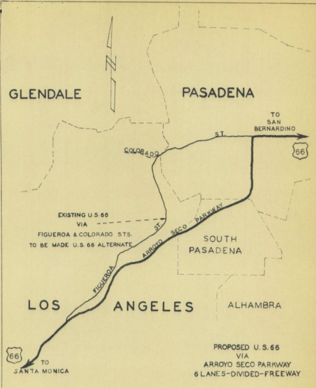
August 1940 California Highways & Public Works announced the opening of a 3.7-mile unit of the Arroyo Seco Parkway from Orange Grove Avenue in south Pasadena to Avenue 40 in Los Angeles. The initial segment of the Arroyo Seco Parkway served as a new mainline alignment of US Route 66.


On September 7th, 1940, the California State Highway Engineer submitted a request to reroute US Route 66 onto the Arroyo Seco Parkway and redesignate the older route on Figueroa Street co-signed with California State Route 11 as US Route 66 Alternate. On October 9th, 1940, the AASHO Executive Secretary responded and advised that seeking AASHO approval to reroute US Route 66 was unnecessary given the rerouting was entirely in a California Metropolitan Area. While not directly stated the AASHO Executive Secretary did not disapprove of the existence of US Route 66 Alternate. With the indirect approval by the AASHO US Route 66 Alternate became the new highway designation over the Colorado Street Bridge west of downtown Pasadena.


In 1964 the California State Highway Renumbering took effect which would heavily impact highway corridors throughout the State. The 1964 California State Highway Renumbering eliminated Legislative Route Numbers in favor of field signage, minimized multiplexes, eliminated US Routes that didn't cross the State Line, and assigned field signage to former Legislative Route Numbers which lacked it.
US Route 66 was approved to be truncated from Los Angeles to US Route 95 in Needles by the AASHO on November 14th, 1963. US Route 66 was effectively immediately removed from the Pasadena Freeway (formerly the Arroyo Seco Parkway) with signage being truncated to Pasadena. This measure left only California State Route 11 as the only signed highway on the Pasadena Freeway. US Route 66 thusly terminated at California State Route 11 along Colorado Boulevard in downtown Pasadena.
US Route 66 Alternate which had previously been concurrent with California 11 between the Arroyo Seco Parkway and Pasadena was approved to be deleted by the AASHO Executive Committee on October 20th, 1963.
The 1964 State Highway Renumbering defined California State Route 248 as "Route 134 near Pasadena to Route 210 near Monrovia." California State Route 248 was comprised of what had been US Route 66 Alternate from California State Route 134 east over the Colorado Street Bridge east to California State Route 11 in downtown Pasadena. From California State Route 11 the remaining balance of California State Route 248 was initially signed as US Route 66 to the planned Interstate near Monrovia. California State Route 248 can be seen for the first time on the
1964 Division of Highways.


1965 Legislative Chapter 1372 added a condition to the description of California State Route 248:
"This route will cease to be a state highway when Interstate 210 freeway is completed and the commission relinquishes that portion of present Route 210 in the County of Los Angeles and the Cities of Pasadena, Arcadia, and Monrovia."
Signage of US Route 66 would be truncated from Pasadena to US Route 95 when Interstate 40 was completed through the Bristol Mountains in 1972. California State Route 248 thusly appears on the
1975 Caltrans Map signed as California State Route 66.
1986 Legislative Chapter 928 truncated California State Route 248 out of Pasadena to the eastern city limit. The new definition of California State Route 248 from the east city limit of Pasadena to Route 210 near Monrovia appears on the
1988 Caltrans Map.
The remainder of California State Route 248 was deleted by way of 1992 Assembly Bill 3090/Chapter 1243.
Part 2; former California State Route 248 on the Colorado Street Bridge
The Colorado Street Bridge is a concrete arch span that opened to traffic on December 12th, 1913. Below, the Colorado Street Bridge can be seen in photos taken in 2011. As noted in Part 1 the Colorado Street Bridge briefly was the western terminus of US Route 66 and was part of California State Route 248 between 1964-1986.
Sources:


Comments