
Drouin Covered Bridge - Quebec


Originally known as the Spafford Covered Bridge after a family that once owned land nearby, the Drouin Covered Bridge was constructed between 1886 and 1889 and is the second bridge to be located at this site across the Coaticook River. Located in the Eastern Townships of Compton, Quebec, the Drouin Covered Bridge is built in a multiple Kingpost design at a length of 98 feet. Wooden plank drop siding and a portal without jamb are featured in its construction. No longer open to vehicular traffic, the bridge is located off of Chemin Drouin between Waterville and Compton, near a landing where you can take small boats that allow you take in the views of the covered bridge.

In 1886, the first Spafford Bridge collapsed under the weight of Patrick Ryan along with his horse and wagon. Due to the unfortunate event, Ryan sued Compton Township for $275, eventually settling with the township for $100. At the same time, arrangements to construct a new covered bridge were underway. A contract was awarded to Daniel Saultry for $908.50 and construction for the new bridge was completed in 1889. During the 1960s, the bridge's span was reduced with the addition of a steel pier at the bridge's west abutment and strengthened with the addition of steel beams underneath each end of the timber trusses. Around 1980, the covered bridge could no longer support heavy traffic and a new parallel bridge was built to the north.

While the covered bridge was no longer open to traffic, additional changes were coming to the bridge. In 1989, the name of the bridge was officially renamed as the Drouin Covered Bridge, in honor of the family that occupied the nearby lands for four generations following the departure of the Spaffords. By 1998, the covered bridge was faced with demolition due to its deteriorating state. Fortunately, a group organized and ran a fundraising effort to the save the Drouin Covered Bridge. Renovations took place in 2004 and 2005 at the cost of $130,000.

Today, you can visit the Drouin Covered Bridge for passive recreation. There is a small parking area located near the bridge and there are some interpretive signs that tell of the bridge's history and design. It is a short walk to the parallel bridge if you want to get some additional photos of the covered bridge. The Drouin Covered Bridge stands as a testament to the history of the Eastern Townships region and the people who made it what it is.


Inside the covered bridge.

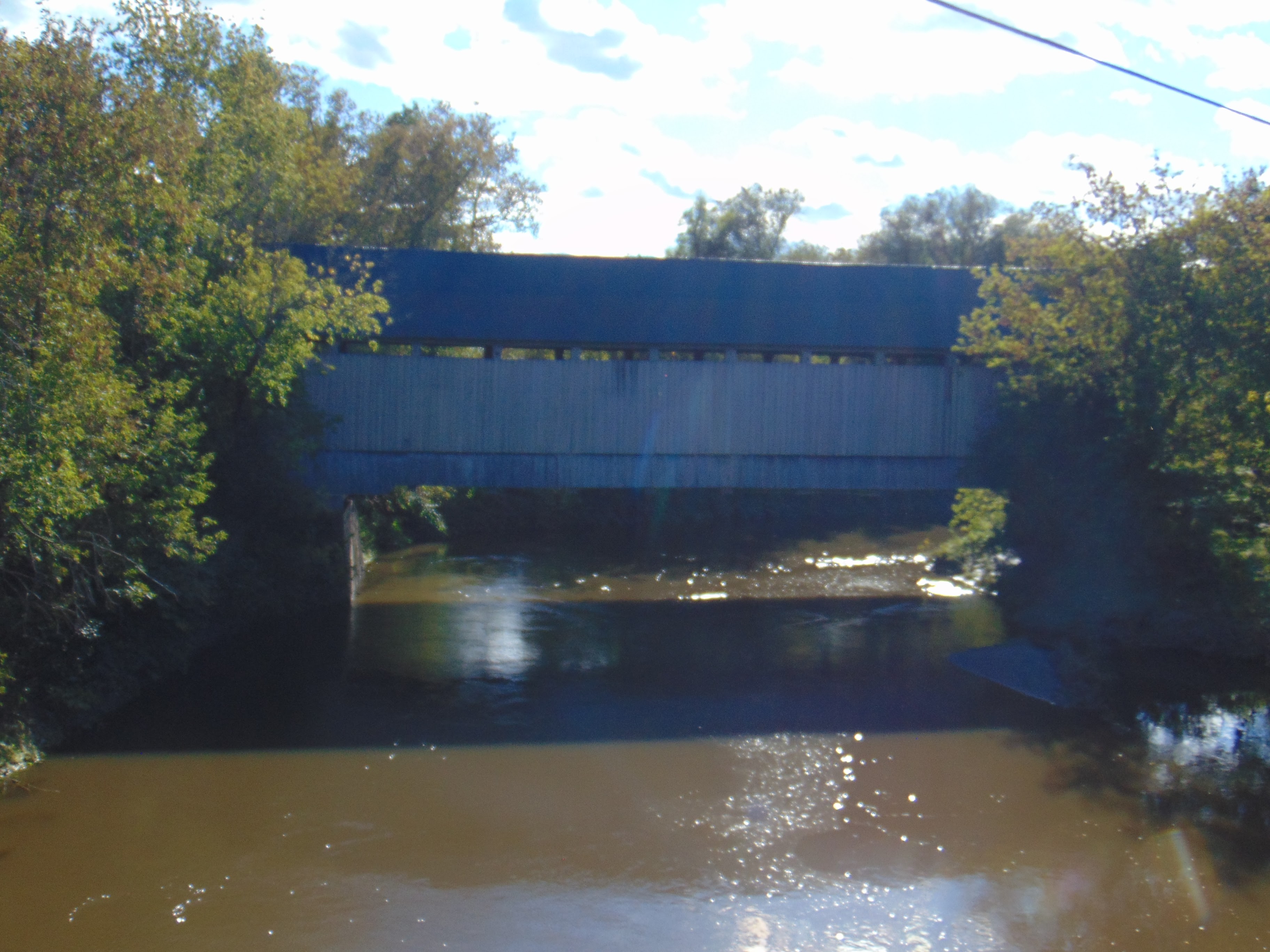
A view of the Drouin Covered Bridge over the Coaticook River from Chemin Drouin.

Bridge plaque on top of the covered bridge's portal.

An interpretive sign for the bridge's history. It is worn, but it still tells the bridge's story.

All about Kingpost trusses.

A view of the west portal of the Drouin Covered Bridge.


How to Get There:


Sources and Links:
DaleJTravis.com - Quebec Covered Bridges
Culture et Communications Quebec - Drouin Covered Bridge
ProvinceQuebec - Covered Bridges
Eastern Townships - Discovering the Covered Bridges of the Eastern Townships
Structurae - Drouin Bridge

Comments

Popular posts from this blog

2018 Mojave Road Trip Part 2; The deadly desert highway (California State Route 127 and Nevada State Route 373)

After leaving Barstow via Old Highway 58 my next destination was in Death Valley.  To access Death Valley from rural San Bernardino County required a trek on north on Interstate 15 to California State Route 127 which becomes Nevada State Route 373 at the state line. Along I-15 I encountered the road sign oddity that is Zzyzx Road about eight miles south of Baker.   Zzyzx Road is a four mile road that used to go to the Zzyzx Mineral Springs and Health Spa.   The spa was founded in the 1940s and the owner made up the name "Zzyzx" to claim it was the last word in the English Language.  The spa has been shut down since the 1970s and is now part of a Desert Studies Center for California State University. The southern terminus of CA 127 in Baker is located at I-15 exit 246.  CA 127 is a 91 mile north/south highway which runs to the Nevada State Line in Inyo County.  CA 127 is called Death Valley Road from I-15 northward.  South of CA 127 ...

Finding the Pre-Emption Road of New York State

  The Pre-Emption Road (or rather a series of roads named Pre-Emption Road) follows a survey line called the Pre-Emption Line, drawn in the early days of the United States. The story begins with Massachusetts and New York having competing land claims to modern day Western New York State that have their roots in colonial charters granted by the British. After the Revolutionary War ended, this land became the frontier of the nation and its settlement became a priority for the new American government. During this era, there were a lot of competing land claims that needed to be settled. It was no different with the land claims between New York State and Massachusetts. On November 30, 1786, Massachusetts and New York sent representatives to Hartford, Connecticut to resolve their competing land claims. In less than three weeks, the representatives had reached a compromise. Massachusetts would receive pre-emption rights, meaning the right to sell the land after the Indian title ...

What's In a Name?: When the Roads Really Do Tell a Story

  Our tagline on the Gribblenation blog is "because every road tells a story". Some roads tell different stories than others. Along our travels, we may see historic markers that tell us a little story about the roads we travel or the places we pass by. Some historic markers are more general, as to telling us who lived where or what old trail traversed between two towns. During my travels across New York State and other states or provinces, I pass by many historic markers, some with interesting or amusing references to roads. I wanted to highlight a few of the markers I've seen along my travels around the Empire State and help tell their stories. Those stories may be as specific as explaining the tales of a tree that was used to help measure a distance of eight miles from Bath to Avoca in Steuben County, as referenced on the Eight Mile Tree historical marker above. They may also help point the way along historical roads first used centuries ago, or may help tell a local l...