

Part 1; the history of Hawaii Route 32
The Island of Maui seemingly was not part of the original World War II era Hawaii Route System. Circa 1955 the United States Bureau of Public Roads renumbered the Hawaii Route System. The 1955 Hawaii Route Renumbering saw most of the conventions utilized by the current Hawaii State Route System established. Primary Hawaii Routes were given two-digit numbers whereas Secondary Hawaii Routes were given three-digit numbers. The Hawaii Routes were assigned in sequence for what Island/County they were located on coupled with what Federal Aid Program number they were tied to. In the case of the Island of Maui it was assigned numbers in the range of 30-40.
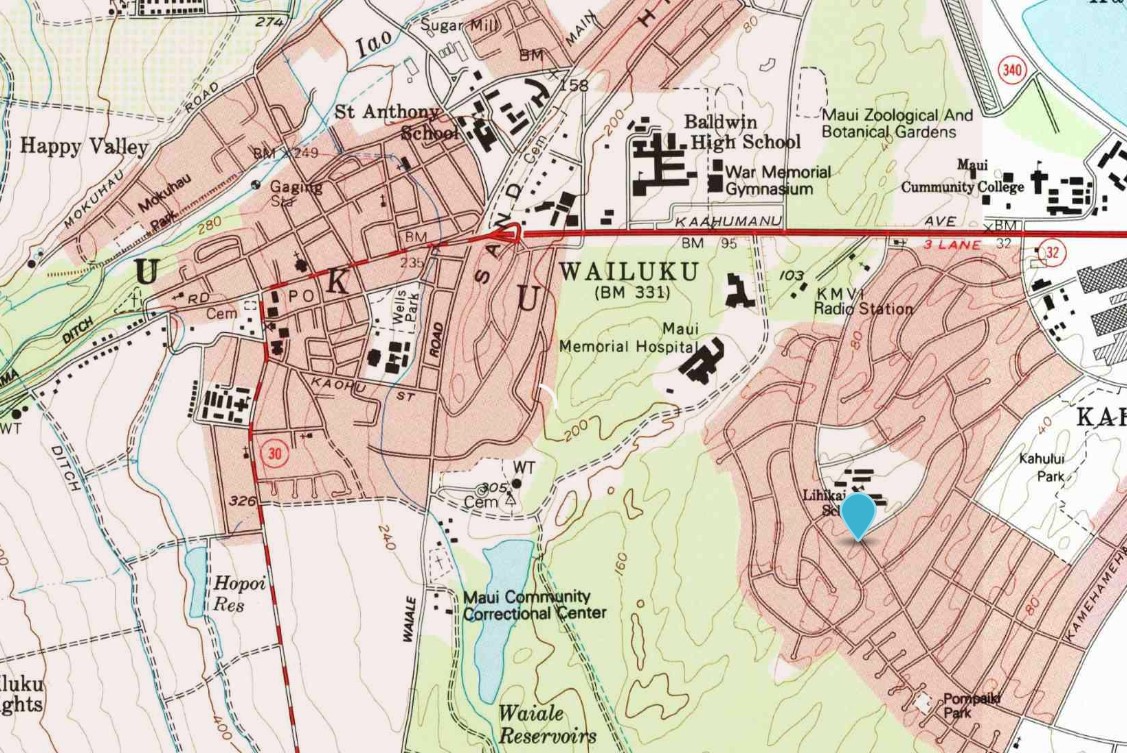
Hawaii Route 32 was aligned from Hawaii Route 36/Hana Highway in Kahului west to Iao Valley Road in Wailuku. Hawaii Route 32 west aligned west of Hawaii Route 30 initially seemingly to align traffic via a sign route towards Iao Valley and the Iao Needle in the West Maui Mountains. The original configuration of Hawaii Route 32 can be seen on the 1955 United States Geological Survey map of Wailuku.

During the 1960s the Hawaii Route system was simplified which led to numerous designations being truncated or reassigned as County Routes. Hawaii Route 32 seemingly was truncated to Hawaii Route 30 in Wailuku. What had been Hawaii Route 32 west of Hawaii Route 30 was reassigned as part of unsigned Maui County Route 320. Maui County Route 320 followed Iao Valley Road west of Main Street to what is now Iao Valley State Monument. Hawaii Route 32 appears truncated to Hawaii Route 30 on the 1983 United States Geological Survey map of Wailuku.
It is unclear when Hawaii Route 32 was extended east of Hawaii Route 36 via Kaahumanu Avenue to Hawaii Route 32A at Hobron Avenue given both designations rarely are displayed on maps.
Part 2; a drive on Hawaii Route 32
Hawaii Route 32 westbound begins from Hawaii Route 32A at Kaahumanu Avenue in Kahului.

Hawaii Route 32 westbound does not have a transition to Hawaii Route 36/Hana Highway.

Hawaii Route 32 westbound intersects unsigned Hawaii Route 32B at Wharf Street.

Hawaii Route 32 westbound intersects Hawaii Route 3500 at Puunene Avenue.


Hawaii Route 32 westbound intersects Hawaii Route 3400 at Kahului Beach Road.


Hawaii Route 32 westbound follows Kaahumanu Avenue into Wailuku. Hawaii Route 32 westbound crosses under the Naniola Drive Overpass and transitions onto Main Street towards downtown Wailuku. The Naniola Drive Overpass is a concrete rigid frame bridge which was constructed during 1936.


Hawaii Route 32 crosses over the Waiale Road Bridge approaching downtown Wailuku. The bridge over Waiale Road was also constructed during 1936 and was added to the National Register of Historic Places during 1998. Waiale Road was once part of Hawaii Route 34.

As westbound Hawaii Route 32 enters downtown Wailuku via Main Street it intersects the unsigned eastern end of the Hawaii Route 32 Bypass at Kinipopo Street.

Hawaii Route 32/Main Street westbound intersects Maui County Route 330 at Market Street in downtown Wailuku. Despite still being signed as Hawaii Route 33 the designation was dropped during 1968 and replaced with Maui County Route 330.


Hawaii Route 32 westbound terminates at Hawaii Route 30/High Street in downtown Wailuku. The unsigned Maui County Route 320 continues ahead via Main Street and Iao Valley Road to Iao Valley State Monument.


Hawaii Route 32 Bypass is located entirely in Wailuku and is only a half mile long. Hawaii Route 32 Bypass eastbound begins at Wells Street from Hawaii Route 30/High Street.

Hawaii Route 32 Bypass follows Wells Street and Kinopopo Street to mainline Hawaii Route 32 at Main Street. Hawaii Route 32 Bypass does not have westbound reassurance shield approaching Kinipopo Street as noted in Part 2.
According to hawaiihighways.com, Hawaii Route 32 Bypass was never part of the State Highway System. Highway Route 32 Bypass seems to be the last vestige of the numerous bypass routes which were once signed in Wailuku. An embossed Hawaii Route 32 Bypass shield assembly can be seen in a photo dated to 2001 at the corner of Kinipopo Street and Wells Street here.
Part 4; Hawaii Route 32A and Hawaii Route 32B
Hawaii Route 32A is a 0.4-mile State Highway in Kahului which begins from Hawaii Route 36/Hana Highway and heads northward via Hobron Street to Pier 1 at Kahului Harbor. According to highwayhighways.com, Hawaii Route 32A was originally designated as Hawaii Route 361. It isn't fully clear when the designation of Hawaii Route 361 was swapped to Hawaii Route 32A or when it was added to the State Highway System.
Hawaii Route 32A northbound can be seen beginning from westbound Hawaii Route 36/Hana Highway.

Hawaii Route 32A northbound on Horbon Street is very well signed with reassurance shields. Hawaii Route 32A intersects Hawaii Route 32 at Kaahumanu Avenue.

Hawaii Route 32A northbound terminates at Pier 1 of Kahului Harbor.


Hawaii Route 32B is a 0.2-mile State Highway in Kahului which begins from mainline Hawaii Route 32/Kaahumanu Avenue and follows Wharf Street to Pier 2 at Kahului Harbor. Unlike Hawaii Route 32A, the entire routing of Hawaii Route 32B is not signed. It isn't fully clear when designation of Hawaii Route 32B was added to the State Highway System.
Hawaii Route 32 westbound intersects unsigned Hawaii Route 32B at Wharf Street.
There appears to be no indication or any reference to Hawaii Route 32B along Wharf Street approaching the gate to Pier 2 of Kahului Harbor.

Comments