
Some 620 miles away from the historic National Road's eastern end in Cumberland, Maryland is the western end of the historic road in Vandalia, Illinois. The National Road (or Cumberland Road) was planned to go through and later built to Vandalia for a few reasons. Vandalia holds the distinction of being founded to serve as the state capital of the great State of Illinois. In 1819, the United States Congress donated land to the state of Illinois for a capital and five commissioners were assigned the task of picking the location for the future state capital that wasn't prone to flooding like the original state capital in Kaskaskia. A trip up the Kaskaskia River in May 1819 brought the group to an area known as Reeve's Bluff, located on the river's west bank, and this area was chosen to be the state capital and became Vandalia. The route of the National Road through Illinois was chosen because Vandalia was capital. Abraham Lincoln was in Vandalia early in his political career, serving as a state legislator during the time when the National Road reached Vandalia, and both the man and the road continue to play prominent roles in the story of this small Midwestern city.
When federal funding for the National Road was eventually discontinued following the Panic of 1837, the National Road had only reached as far west as Vandalia. At that time, it became the first road in the United States to use macadam road surfacing, which was a new technology at the time. During the 1830s, the federal government conveyed part of the responsibility to the states through which the National Road runs. Tollgates and tollhouses were then built by the states. Plans were made to continue the National Road to either Alton, Illinois at the confluence of the Mississippi and Missouri Rivers or St. Louis, Missouri and on to Jefferson City, Missouri upstream on the Missouri River. However, funding ran dry after $6.8 million was spent on constructing the National Road, stopping construction and leaving the terminus at Vandalia, Illinois. Certain groups wanted the road to continue to St. Louis, while others wanted it to go north to Alton. Neither group got their way, as the controversy and financial situation of the day caused Senator Henry Clay, a major advocate of the National Road, to give up on the project and authorize any remaining transportation funding of the day go to emerging transportation alternatives such as railroads and canals.
A "Madonna of the Trail" monument was placed in Vandalia at the old
Vandalia State House Building, commemorating the western terminus of the National Road. The monument was put in place in 1928 by the Daughters of the American Revolution as a tribute to the pioneer women who traveled the National Road. The
National Old Trails Road also went through Vandalia as a way of linking the old pioneer roads to early automobile travel. Today, the history of the National Road is still prevalent in Vandalia. While Vandalia has not been the state capital of Illinois since 1839, there is still a strong sense of history permeating around town. There is a
Historic National Road Interpretive Center to see, but there are plenty of National Road relics to be found throughout a visit to Vandalia as well. Let's take a look.
 |
| A small monument for the National Road (or Cumberland Road) found on the grounds of the Old State House in Vandalia. |
 |
| Historic National Road scenic byway signage found in downtown Vandalia. |
 |
| Downtown Vandalia on a quiet summer morning. |
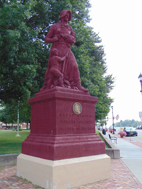 |
| Madonna of the Trail statue, one of a dozen statues that were placed along the National Old Trails Road. This particular statue was chosen to be placed in Vandalia due to the significance of the National Road ending in Vandalia. |
 |
| Inscriptions on the base of the statue summarize the story of the National Road. |
 |
| And of Abraham Lincoln. There are plenty of places to find Honest Abe around town, if you're looking for Lincoln. |
 |
| The Old State Capitol building was constructed in 1836 and was the fourth state capitol building in the history of Illinois and is the oldest state capitol building still remaining in Illinois. It only served as the state house for a few years, as the Illinois state capital moved from Vandalia to Springfield in 1839. You can tour the building and apparently it has been restored to the condition during the time when Abraham Lincoln served in the Illinois state legislature in Vandalia. |
 |
| The second and third state capitol buildings were also in Vandalia. After the state capital moved to Springfield, the old state house served as the Fayette County courthouse for nearly a century. |
 |
| You can find references to Abraham Lincoln throughout Vandalia, maybe more so than the National Road. |
 |
| The young Lincoln statue across the street from the Old State Capitol. |
 |
| The statue is located in a small pocket park called Lincoln Park. This is across the way from the Madonna of the Trail statue. |
How to Get There:
Sources and Links:
Vandalia, Illinois -
Explore VandaliaLegends of America -
The National Road – First Highway in AmericaEffingham Daily News -
Vandalia center displays National Road historyNational Road Association of Illinois -
Communities - Central


Comments