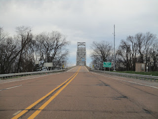
Helena Bridge (Helena-West Helena, AR)


Located along a relatively isolated segment of US Highway 49, the Helena Bridge spans the Mississippi River in the northern reaches of the Mississippi Delta region. Located about 25 miles north of the Delta crossroads city of Clarksdale, this bridge is among the lightest-trafficked bridges on the lower Mississippi River and is one that can easily be missed and forgotten about.

Opened in 1961, the bridge was built to replace an antiquated ferry service in the area and has been part of the US 49 corridor since 1963, when that highway was extended north into Arkansas from Clarksdale along US 61 and a former segment of Mississippi Highway 6. The cost of construction was $14 million and it operated as a toll bridge in its early years until the bonds issued for the project were paid off some time later. The bridge is about one mile long altogether and features a narrow two-lane roadway that lacks modern shoulders. In order to ensure that the approach highways would not be subjected to river flooding, they were built on elevated earthen embankments that span the width of the flood plain. The bridge’s main span consists of a multi-span steel cantilever truss superstructure totaling over half a mile in length. The longest of these spans is 804 ft long, clearing the Mississippi River below with a height of 120 ft. It’s been said that the design of this bridge was inspired by that of the old Benjamin Humphreys Bridge, another steel cantilever bridge of similar appearance, once located downriver near Greenville, MS – a bridge that will be featured as part of a future blog on this site.

On the Mississippi side of the bridge is the Isle of Capri Hotel & Casino Resort and it’s one of the only notable landmarks in the area nowadays. This area generally does not have much to offer, with the bridge being the biggest highlight for bridge enthusiasts alike. The consolidated city of Helena-West Helena on the Arkansas side of the bridge is the county seat and largest city within Phillips County, AR. While the Mississippi Delta has fallen on hard economic times over the last 50 years due to the loss of its manufacturing jobs, this area has a non-negligible amount of history to offer visitors. It was the site of the Civil War’s Battle of Helena in July 1863 and was also home to a thriving blues music community in the 1940s & 50s that rivaled that of Clarksdale, MS nearby, attracting much of the same talent as its counterpart just down US 49. Be sure to check out our blog's article on Clarksdale, a link to it will be provided below.

The following pictures from my February 2023 visit to the Helena Bridge demonstrate the westbound crossing from Mississippi to Arkansas. Click on each photo to see a larger version.

The following pictures from my February 2023 visit to the Helena Bridge demonstrate the eastbound crossing from Arkansas to Mississippi. Click on each photo to see a larger version.


The following pictures from my February 2023 visit to the Helena Bridge were taken from the Mississippi side of the river near the Isle of Capri Resort. Click on each photo to see a larger version.


The following pictures from my February 2023 visit to the Helena Bridge were taken from the Arkansas side of the river near the city of Helena on the Mississippi River. Click on each photo to see a larger version.

The following aerial pictures from my February 2023 showcase the Helena Bridge and its immediate surroundings in the heart of the Mississippi Delta. Click on each photo to see a larger version.

Dashcam video of the westbound drive over the Helena Bridge was filmed in February 2023 for the 'roadwaywiz' YouTube channel and is available for viewing at the link below:

Dashcam video of the eastbound drive over the Helena Bridge was filmed in February 2023 for the 'roadwaywiz' YouTube channel and is available for viewing at the link below:

The Helena Bridge was featured in the "Bridges of the Lower Mississippi River" webinar on the 'roadwaywiz' YouTube channel, beginning at the 45:18 mark:


How To Get There:

Further Reading:
Helena Bridge by John Weeks

Bridges, Crossings, and Structures of the Lower Mississippi River
Next Crossing upriver: Memphis & Arkansas Bridge (Memphis, TN)
Next Crossing downriver: Greenville Bridge (Greenville, MS)
Return to the Bridges of the Lower Mississippi River Home Page
__________________________________________________

Comments

Popular posts from this blog

North Carolina Continues to Move Forward with Rail

2023 and the first half of 2024 have seen continued growth in North Carolina's passenger rail system.  From increased daily trains from Raleigh to Charlotte, federal funds for studying additional corridors, and receiving a historic grant to begin the construction of high-speed rail between Raleigh and Richmond, the last 18 months have been a flurry of activity at NCDOT's Rail Division.  And that's just the tip of the iceberg. As ridership and routes increase - the engine of North Carolina passenger rail trains will become a more common sight. (Adam Prince) Increased Passenger Train Service: On July 10, 2023, a fourth Piedmont round-trip rail service between Raleigh and Charlotte commenced.  The four Piedmont trains plus the daily Carolinian (to Washington, DC, and New York) bring the total of trains serving the two cities daily to five. The current daily Piedmont and Carolinian schedule between Charlotte and Raleigh (NCDOT) The result was over 641,000 passengers utilized pa

The Midway Palm and Pine of US Route 99

Along modern day California State Route 99 south of Avenue 11 just outside the City limits of Madera one can find the Midway Palm and Pine in the center median of the freeway.  The Midway Palm and Pine denotes the halfway point between the Mexican Border and Oregon State Line on what was US Route 99.  The Midway Palm is intended to represent Southern California whereas the Midway Pine is intended to represent Northern California.  Pictured above the Midway Palm and Pine can be seen from the northbound lanes of the California State Route 99 Freeway.   This blog is part of the larger Gribblenation US Route 99 Page.  For more information pertaining to the other various segments of US Route 99 and it's three-digit child routes check out the link the below. Gribblenation US Route 99 Page The history of the Midway Palm and Pine The true timeframe for when the Midway Palm and Pine (originally a Deadora Cedar Tree) were planted is unknown.  In fact, the origin of the Midway Palm and Pine w

US Route 101 in Benbow, Garberville and Redway

The communities of Benbow, Garberville and Redway can all be found along US Route 101 within southern Humboldt County.  The former surface alignment of US Route 101 in Garberville and Redway once crossed the Garberville Bluffs along what is now Redwood Drive via a corridor constructed as part of the Redwood Highway during the 1910s.  US Route 101 through Benbow, Garberville and Redway was modernized by 1935.  US Route 101 would eventually be upgraded to freeway standards in Benbow, Garberville and Redway by extension of the Redwood Freeway during 1966-68.  As the cover photo the original grade of US Route 101 and the Redwood Highway can be seen at the Garberville Bluffs during 1934.  US Route 101 can be seen in the communities of Benbow, Garberville and Redway on the 1935 Division of Highways Map of Humboldt County .   The history of US Route 101 in Benbow, Garberville and Redway Benbow, Garberville and Redway lie on the banks of the South Fork Eel River of southern Humboldt County.  D