Front Rank (L to R) The RT HON Comrade Mister Otto Yamamoto of Hollywood BFMAP, SALF, RSP-mit Tom der Schiavo Hund(actually, just rank), Brian Polidoro, Jeff Kitsko
Back Rank (L to R) Brian Powell, Chris Jordan, Doug Kerr, Alex Nitzman, Jim Hinkson, Mark Sinsabaugh, Corey Dukes, Mike Browne
Photo taken by Adam Prince.
Snaps from before, after and during the meet! Doug Kerr drove. As Usual.
Photos and commentary were taken by Otto Yamamoto in April 2005. We have decided to keep the photos and commentary as true to form as possible to the original article. The photos were hosted by Gribblenation on a previous incarnation of our site, and we are proud to be able to bring back this classic article.
 |
| NY 369 Junction on the IH 88 westbound. |
 |
| Crappy olde text sine for the upcoming NY 17 east split on the southbound IH 81. |
 |
| Doncha hate when you forget something? |
 |
| A slightly longer shot of the bridge. |
 |
| A slightly longer shot of the bridge. |
 |
| The inauspicious END! of US 220, more or less. |
 |
| This is just barely inside New York. There are no US 220 reference markers, but NY claims the END! just the same. |
 |
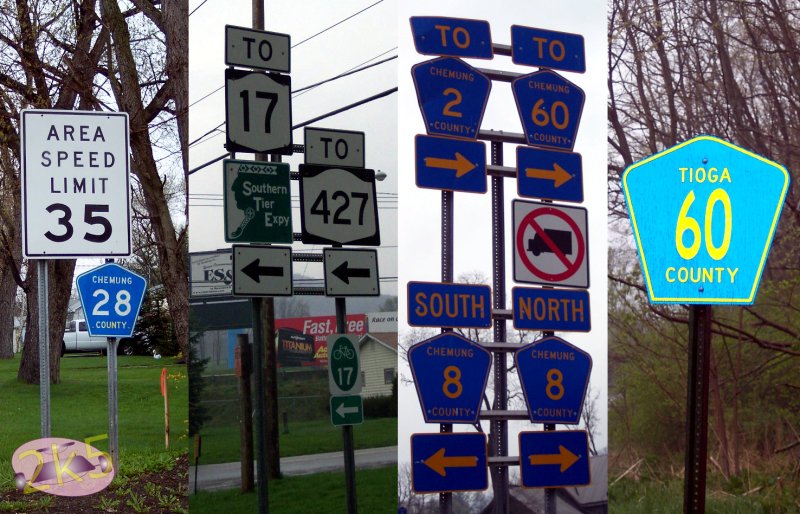
| Facing east on Chemung County Route 60. |
 |
| The Beginning! of US 220. The NY 17 junction is entirely in PA, actually. All appliances and furniture are NYSDOT; but the signals are painted yellow vs. the usual green/black. |
 |
| Standing in the middle of the road, cos I have no sense. |
 |
| Sine Salad! A variety of County and State sines between Waverly and Elmira. |
 |
| Rolling into Elmira to pick up Mark Sinsabaugh. A wonderful human bean and purveyor of New York Routes! |
 |
| Level junctions on NY 17 in Horseheads. As you can see there's work afoot to take all this out and make it into a proper freeway. This shot is westbound at the crossing of Grand Central Avenue. |
 |
| J52 is convoluted junction with NY 14. This marks the resumption of the freeway at Horseheads. |
 |
| A new junction-for the Elmira Corning Airport. |
 |
| And Boom! We warp to the IH 86/US 15[IH 99] junction at Painted Post. This is a flyover in project, obviously. |
 |
| This is a pretty cool temporary support for the flyover girders. |
 |
| Now you know where all the Thugs and Gangstas come from. Gang Mills is number one in Hooligan production in the nation. Seriously, folx; we have more afterthought stylee signage here; including a white-on-white state shield, which occasionally turns up on road works projects. |
 |
| Just in case you missed it-the next offslip goes to NY 417. |
 |
| Still more afterthought bungage. This will all be sorted out someday. |
 |
| Not to be outdone, the second southbound junction has all-caps signage. |
 |
| Over the line in PA, we stop at a future IH 99 bridge. This snap features the Justly Famous Mark Sinsabaugh and the Silver CRV! It's legendary! |
 |
| Another shot of the bridge, which looks cool standing by itself like this. This is looking westbound on PA 49. |
 |
| MUD! Wait til yr father gets home! Don't track that across my floor, Mister! |
 |
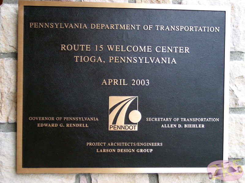
| Tioga Welcome Center dedication plaque. A nice facility, if they can keep it from sliding off the hil |
 |
| Welcome center identification. Just in case yr lost. The star shows your location in the state. |
 |
| Future IH 99 age here. Anticipatory junction number plate and a "Future"; IH 99 Corridor. It would be nice to identify the Town BUS US 15 goes to (Mansfield). What would be rilly cool and funny would be a Future Business Loop IH 99 Shield! |
 |
| Traffic Lite Salad in Mansfield at the junction of BUS US 15 and US 6. This appears to be a goddam plastic Eagle. PA loves these. I'm not overly enamored of Plastic Traffic lights. |
 |
| Closeup of a lens on this install, showing the brand mark. Note how the paint peeling off the light reveals the original body color, which looks better than the paint! |
 |
| The whole signal. This is facing westbound traffic on US 6. |
 |
| The weather was crappy and rainy, so none of the shots between Mansfield and Williamsport looked worth a damn. That's how it goes sometimes. We're entering the northern outskirts of Williamsport, here. |
 |
| Old Schoole text signage approaching the US 15-US 220 junction in Williamsport. I'm not all that keen on the lack of arrows on those sines. |
 |
| Here's the split. Actually the freeway we're joining runs east and west at this point. |
 |
| IH 180 also starts up soon, here. This is the slip carrying US 15 southbound to join US 220. |
 |
| Still on the slip road, joining US 220/IH 180. Maynard Road is a local Williamsport street. |
 |
| We finally join the US 220 freeway. |
 |
| Maynard Street splits, and we’re on the IH 180 now. How about that THIS LANE indication for US 15? |
 |
| Approaching the US 15 split at j27; IH 180 parallels US 15 so it’s a fine alternate. |
 |
| We leave the IH 180 here, so we can turn around. |
 |
| US 15 leaves IH 180, and passes under it; Coming out to the north of the freeway. To the south is a railway and the Susquehanna River. This is just before the turn under the freeway. The SIGNAL AHEAD sign applies to the left lane only; as there is a free turn for US 15. |
 |
| On US 15-the long bridge ahead is the US 15 bridge over the Susquehanna, accessed by the road at the signal ahead. The Jersey Wall on the right separates US 15 and the IH 180 westbound. |
 |
| Here’s that left for US 15 southbound. We didn’t come to the bridge, though, so we didn't cross it. |
 |
| This is the exact opposite direction of the photo above. |
 |
| Back on the Freeway again; heading back to the US 15-US 220 split. The IH 180 ENDS! in here someplace. |
 |
| We’re clear of Downtown Williamsport here and heading south[west] on the US 220 freeway. This is the Reach Road junction. |
 |
| This is the end of the US 220 freeway for now. Old 220 joined at the right-You can see the taper at the right of the snap. There are level junctions and signals ahead. |
 |
| The dual section of US 220 west of Williamsport. |
 |
| Rusty old railway overpass just west of the PA 287 junction. |
 |
| Probably my second favorite series of PA Freeway signs here. This also has an anticipatory EXIT plate- though IH 99 wasn’t thought up at that time. |
 |
| Here’s a puzzler. The ID plate on this bridge says “Conrail”, But no recent map shows an active railway. Terraserver’s photo from 1994 shows what appears to be an abandoned rail right of way. |
 |
| The PA 44 Junction. |
 |
| The back of the eastbound gantry at the PA 44 junction. The signs for this are shown later down this page. I’ve only seen full span truss gantries like this in PA and Louisiana. |
 |
| Between the PA 44 and PA 150 junctions south[west]bound on US 220. This is a pretty old freeway, as can be seen from the surface. |
 |
| A variety of freeway guide signs found on US 220. These likely all date from the ’80’s or earlier. None have reflective backing. This is similar to signage found in California, I’ve seen the like in NJ, AL and GA at various times, too. |
 |
| The Mill Hall junction on US 220. Note the sine rot on the pull through sign. |
 |
| Kinda lumpy, but scenic. I’ll bet this would’ve looked nicer if it were sunny. |
 |
| The Salona junction, with a new Clearview sign; but no anticipatory junction plate. The US 220 freeway ends beyond this junction. |
 |
| The road narrows, and the dual carriageway will end presently. |
 |
| Now on the short two-lane section of US 220 leading to the IH 80. |
 |
| Highway Advisory Radio Advisory for IH 80. An “URGENT MESSAGE” would likely mean you’re stuck; as the only way out of here besides the IH 80 is to turn around. |
 |
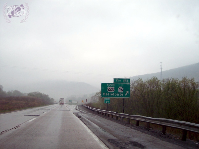
| South of Interstate 80 on US 220-IH 99. PA 26 is part of the mix until this point, as well. |
 |
The inauspicious resumption of the IH 99 from IH 80. It’s going to be upgraded to a freeway junction.
|
 |
| Nice long shot of the IH 99 southbound heading toward State College. |
 |
| Oh noes! Somebody squisheded the US 322 shield here! There’s also a spot for the IH 99 shield that will go here, whenevar PennTRANS decides it's time to post it. |
 |
| All kinds of roadly goodness here. We’re facing north at the US 220-US 322 EAST/Park Avenue junction. This is northeast of State College. US 220[IH 99} is overhead. I don’t know what “Innovation Park” is; but it apparently rates elevated junctions. |
 |
| Temporary alignment of US 20-US 322 west of State College, Flanking a new IH 99 viaduct over Sellers Lane. |
 |
| US 220-US 322 weave under the future IH 99 west of State College. |
 |
| On foot at the PA 550 undercrossing of the IH 99. |
 |
| When construction crews started digging out for this section of the freeway they found a huge amount of acid rock- This is a catchment basin for runoff from the works; The acidity is monitored and adjusted so that groundwater isn’t contaminated. |
 |
| Mark Sinasabaugh, Chris Jordan, Brian Powell and Jeff Kitsko have a look at the catchment basin. |
 |
| Constructiony-like stoof at the PA 550 overpass. |
 |
| Checking out the northbound PA 550 overpass.... |
 |
| Another shot, sans PPL out on the actual bridge. |
 |
| It’s a long way back down to PA 550 from here. |
 |
| The clearance between roads is emphasized in this shot. IH 99 will basically fly over everything in the area. |
 |
| These are two containers for the alkali buffer used in the acid abatement. This is nasty stuff. Very caustic. |
 |
| Another look at the catchment for stormwater. |
 |
| Back on the road again; approaching the junction with Alternate US 220. This was mainline US 220 before the construction of the new sections of the IH 99. |
 |
| Another IH 99 bridge over US 220 northeast of Port Matilda. |
 |
| US 322 splits for Phillipsburg; and IH 99 gets it’s first mention on signage in Port Matilda. |
 |
| Back over again with the IH 99- This time at Reese Hollow Road, southwest of Port Matilda. |
 |
| Temporary traffic lite goodness at the junction. |
 |
| A look at a pier under construction; and some sort of frame-perhaps for working with rebar. I’m not sure on that one. |
 |
| Looking northwest at the air flyover. |
 |
| Future junction 61 on the IH 99 Near Port Matilda. |
 |
| Alex Nitzman leads the charge up a nearly complete IH 99 junction. Jeff Kitsko is on the left; and he’s explaining stoof. |
 |
| The beginning of a dual section of US 322 Northwest of Port Matilda |
 |
| The westbound junction for Reese Hollow and East Mountain Roads on the dual US 322. Eastbound, this is a level junction. |
 |
| The end of the Dual carriageway on US 322 heading towards Phillipsburg. |
 |
| A rock cut on US 322 northwest of Port Matilda. |
 |
| More US 322 in between Port Matilda and Phillipsburg. |
 |
| Graphic sine for the Bonzer Downgrade into Phillipsburg. For a state with no real mountains, PA seems loaded w/bonzer downgrades like this. |
 |
| Mandatory truck stop/brake check for Phillipsburg Hill. |
 |
| Phillipsburg Sine Salad! |
 |
| Old stone mileage marker in Phillipsburg. |
 |
| Olde Logge Cabin in Phillipsburg |
 |
| More frontier forefather and foremotherly goodness. A front view this time. |
 |
| Here’s a new bridge going up on Locust Street next to the Sheetz in Phillipsburg. I think it’s unfair that there are no other bugs that get streets named after them. Locusts aren’t even a good bug, but they get streets named after them just the same. |
 |
| Rebar goodness on the Bug Street Bridge. |
 |
| We dropped down PA 350 to Bald Eagle to catch the current END! of IH 99. There was plenty o’ button-copy goodness to be had. |
 |
| A poor beat-up old sine in Bald Eagle; Doug Kerr and Mike Browne are walking back from looking at something else. |
 |
| IH 80 trailblazers miles from the IH 80. No signage here indicating the continuation of the IH 99, though. |
 |
| The Future IH 99 crossing over PA 350 north of the END! |
 |
| A closeup of the piers, on the bridge. Doug, Mike and Mark are having a look at things. |
 |
| A closer look yet at the piers and girders, all nekkid and exposed. This is hard core road pr0n! Hide yr chirren’s eyes. |
 |
| We headed back up to State College via back roads- one of which was PA 550, which was closed in a section. |
 |
| Here’s a funky “Y” junction sine. |
 |
| Rural goodness east of State College. We were heading back to US 220 in a roundabout way. |
 |
| More Roundaboutness on PA 192, here. |
 |
| PA 445 was part of the Roundabout goodness. Here’s it’s northern END! |
 |
| The END! of PA 64 in Mill Hall. We’re really close to US 220, now. |
 |
| But there’s no fun in taking the direct route, then, is there? We’re on PA 150 just west of Lock Haven. |
 |
| This interesting signal configuration covers the junction with 2nd and Barton Streets in Lock Haven |
 |
| Unique Fire Brigade warning signal in Lock Haven. The signal ahead is for Park Street. |
 |
| A five-point junction where PA 150 splits into a one-way couplet in Lock Haven. Such a location is a good place for the requisite Memorial to Something you often find in small towns. |
 |
| PA 120 quasi-freeway spur in Lock Haven. |
 |
| Looking almost like a freeway, here, innit? Don’t worry, there’s a level junction ahead. Note the destination of south US 220 is Milesburg- The rerouting of US 220 wasn’t anticipated when this was built. |
 |
| Here’s the reverse of the truss gantry pictured above. And we’ve come pretty well full circle in this area. Interesting that the farthest destination is listed first. |
 |
| So heading back home, we didn’t exactly take a direct route- Here’s a truss bridge on PA 287... |
 |
| ..And a traffic light in Wellsboro. |
 |
Now here’s a fine nite shot of a NY 221 sine in a terminal state. Which means it’ll be at least 15 years before it’s replaced. Or the route will be decommissioned. Yr choice.
There’s a funny story with this. Doug pulled up to snap this thing; Oddly there was a state trooper close by, and we were pulled over, he asked Doug what we were up to; Doug said: “Oh, I’m an artist”. The trooper accepted that and we were on our way. Now that’s quick thinking in the dead o’ nite!
(Note from Doug Kerr: I can confirm this happened.) |
 |
| Finishing out this adventure, here’s some IH 88 sines. Taken in the dead o’ nite-I know not where... Cos I was half dead meself. It was a training run for the 27 hours of Maine! |
Sources and Links:


Comments