Freeport Covered Bridge - Quebec


Located in Cowansville, Quebec, the Freeport Covered Bridge (or Pont de Freeport, in French) was built in 1870 and spans 91 feet long over the Yamaska River, west of downtown Cowansville. The covered bridge was constructed in the Town through truss design that is fairly common throughout Quebec. The covered bridge and the former village of Freeport where the Freeport Covered Bridge is located was built was named for Freeman Eldridge, who was a builder in the region which include built the first Anglican church in Freeport in 1855. The former village of Freeport, along with the former villages of Sweetsburg and Nelsonville, were combined in 1876 to form Cowansville.

This historic covered bridge as led a quiet existence for most of its lifespan so far. The Freeport Covered Bridge underwent some renovations in 1992, where steel support was added to its infrastructure. In 2014, modern street lighting was added to the bridge. Additional restorations were made with the addition of headache bars after being damaged twice by large trucks over the years. There is a sign on both sides of the bridge asking cars to honk before entering its dark interior, as it is a narrow one lane bridge. The covered bridge is a local attraction and you have the opportunity to enjoy the surroundings of this bridge with its distinctive red color paneling. Picnic tables and parking was added for tourists to come to visit, plus there is a small trail that allows you to get some sneak peaks of the bridge from a different angle.
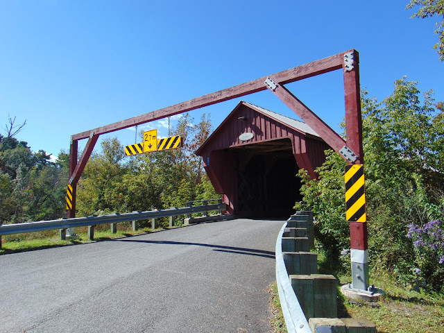
A view of the east portal of the covered bridge, along with a headache bar meant to protect the bridge from damage.

Side profile of the bridge near the picnic area. I couldn't get a great photo of the bridge from this angle.

Inside the covered bridge.

Bridge plaque.

View of the covered bridge from the west portal.


How to Get There:


Sources and Links:
QuebecPanorama - Pont couvert - Pont de Freeport
Structurae - Pont de Freeport
1000 Towns of Canada - Pont Couvert Freeport
DaleJTravis.com - Quebec Covered Bridges

Comments

Popular posts from this blog

North Carolina Continues to Move Forward with Rail

2023 and the first half of 2024 have seen continued growth in North Carolina's passenger rail system.  From increased daily trains from Raleigh to Charlotte, federal funds for studying additional corridors, and receiving a historic grant to begin the construction of high-speed rail between Raleigh and Richmond, the last 18 months have been a flurry of activity at NCDOT's Rail Division.  And that's just the tip of the iceberg. As ridership and routes increase - the engine of North Carolina passenger rail trains will become a more common sight. (Adam Prince) Increased Passenger Train Service: On July 10, 2023, a fourth Piedmont round-trip rail service between Raleigh and Charlotte commenced.  The four Piedmont trains plus the daily Carolinian (to Washington, DC, and New York) bring the total of trains serving the two cities daily to five. The current daily Piedmont and Carolinian schedule between Charlotte and Raleigh (NCDOT) The result was over 641,000 passengers utilized pa

The Midway Palm and Pine of US Route 99

Along modern day California State Route 99 south of Avenue 11 just outside the City limits of Madera one can find the Midway Palm and Pine in the center median of the freeway.  The Midway Palm and Pine denotes the halfway point between the Mexican Border and Oregon State Line on what was US Route 99.  The Midway Palm is intended to represent Southern California whereas the Midway Pine is intended to represent Northern California.  Pictured above the Midway Palm and Pine can be seen from the northbound lanes of the California State Route 99 Freeway.   This blog is part of the larger Gribblenation US Route 99 Page.  For more information pertaining to the other various segments of US Route 99 and it's three-digit child routes check out the link the below. Gribblenation US Route 99 Page The history of the Midway Palm and Pine The true timeframe for when the Midway Palm and Pine (originally a Deadora Cedar Tree) were planted is unknown.  In fact, the origin of the Midway Palm and Pine w

US Route 101 in Benbow, Garberville and Redway

The communities of Benbow, Garberville and Redway can all be found along US Route 101 within southern Humboldt County.  The former surface alignment of US Route 101 in Garberville and Redway once crossed the Garberville Bluffs along what is now Redwood Drive via a corridor constructed as part of the Redwood Highway during the 1910s.  US Route 101 through Benbow, Garberville and Redway was modernized by 1935.  US Route 101 would eventually be upgraded to freeway standards in Benbow, Garberville and Redway by extension of the Redwood Freeway during 1966-68.  As the cover photo the original grade of US Route 101 and the Redwood Highway can be seen at the Garberville Bluffs during 1934.  US Route 101 can be seen in the communities of Benbow, Garberville and Redway on the 1935 Division of Highways Map of Humboldt County .   The history of US Route 101 in Benbow, Garberville and Redway Benbow, Garberville and Redway lie on the banks of the South Fork Eel River of southern Humboldt County.  D