
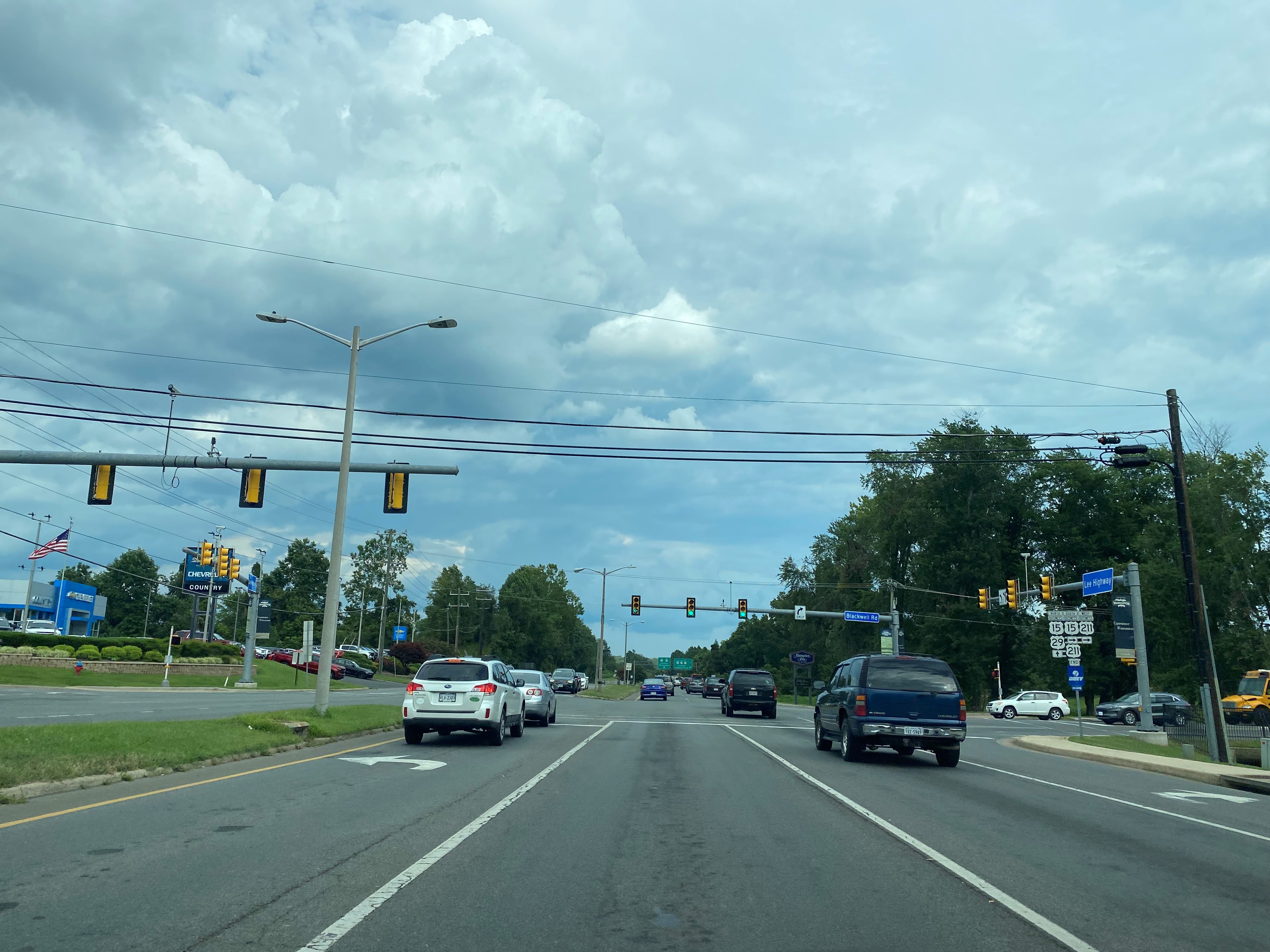
US Route 211 is a 59.09-mile US Route entirely contained to the state of Virginia. US Route 211 was one of the original US Routes which was defined during November 1926. Since 1980 the eastern terminus of US Route 211 has been located in Warrenton, Virginia at the corner of Lee Highway and Blackwell Road. The eastern terminus of US Route 211 is notable due to it ending at it's own Business Route which had been created during 1974. Following US Route 15, US Route 17 and US Route 29 being realigned onto the Warrenton Bypass during 1986 the eastern terminus of US Route 211 has remained disconnected from all mainline US Routes. Pictured above is the eastern terminus of US Route 211 at Lee Highway and Blackwell Road in Warrenton.
Note: US Route 211 is a highly scenic corridor which traverses Thornton Gap in the Blue Ridge Mountains of Shenandoah National Park. During July 2020, Doug Kerr published a blog on Gribblenation pertaining to the entirety of US Route 211:
A morning on Virginia's US Route 211 (gribblenation.org)
Part 1; the history of US Route 211 in Warrenton, Virginia
The US Route System was officially created on November 11, 1926, by the American Association of State Highway Officials. As originally defined US Route 211 began at US Route 11 in New Market and terminated at US Route 50 in Fairfax. US Route 211 from the outset was overlaid completely with the Auto Trail known as the Lee Highway. US Route 211 can be seen plotted from New Market and Fairfax on the 1927 National Map Company sectional map.

According to usends.com, US Route 211 was extended into the District of Columbia at some point after 1929. The exact time frame for the extension of US Route 211 to the District of Columbia is unclear as no application appears in the American Association of State Highway Transportation Officials database. US Route 211 ended in the District of Columbia via K Street NW at US Route 1/17th Street NW. US Route 211 can be seen entering the District of Columbia via Lee Highway in Arlington and the Francis Scott Key Bridge co-signed with US Route 29 on the 1940 Rand McNally Map of Virginia.

According to usends.com, US Route 211 was withdrawn to the Francis Scott Key Bridge in Arlington at some point after 1948. No application to withdraw US Route 211 to Arlington is known to exist within the American Association of State Highway Transportation Officials database. US Route 211 can be seen terminating at the Francis Scott Key Bridge in Arlington on the 1956 Gousha Map of the District of Columbia.

During 1974 the Virginia Department of Transportation submitted an application for US Route 211 and US Route 15 to be realigned in Warrenton. The below letters from the American Association of State Highway Officials Executive Secretary and Virginia Department of Transportation Deputy Director dated May-June 1974, acknowledges the creation of the US Route 211 and US Route 15 Business Routes in Warrenton. US Route 211 had been realigned through Warrenton co-signed with US Route 15-29 via Broadview Avenue and Lee Highway. US Route 211 Business followed the original alignment of the highway through downtown Warrenton via Waterloo Street, Alexandria Pike and Blackwell Road.


On April 18, 1980, the Virginia Department of Transportation requested US Route 211 being truncated from the Francis Scott Key Bridge in Arlington to the corner of Lee Highway and US Route 15-211 Business at Blackwell Road in Warrenton. The American Association of State Highway Transportation Officials approved the truncation of US Route 211 to Warrenton on June 24, 1980.


During late year 1986 US Route 15, US Route 17 and US Route 29 were realigned onto the Warrenton Bypass. The realignment of US Routes 15-17-29 led to the circumstance existing now where US Route 211 has a floating eastern terminus at Lee Highway/Blackwell Road which is disconnected from another mainline US Route.
Part 2; a drive on mainline US Route 211 in Warrenton
US Route 211 eastbound enters Warrenton via Lee Highway and Frost Avenue. US Route 211 eastbound traffic is directed to turn left onto Broadview Avenue with US Route 17 Business northbound and US Route 29 Business eastbound. US Route 211 Business eastbound is directed to continue straight onto Waterloo Street.


US Route 211 eastbound follows Broadview Avenue co-signed with US Route 17 Business northbound and US Route 29 Business eastbound. Strangely US Route 15 northbound signage also appears on Broadview Avenue. US Route 211 eastbound and US Route 29 Business eastbound depart onto Lee Highway with US Route 17 Truck southbound. US Route 17 Northbound departs from US Route 211 eastbound via Broadview Avenue.


US Route 211 eastbound is co-signed on Lee Highway to it's terminus at Blackwell Road with US Route 29 Business eastbound and US Route 17 Truck southbound. The terminus of US Route 211 is located at the junction of US Route 211 Business and US Route 15 Business.

From the US Route 211 eastern terminus US Route 29 Business eastbound, US Route 15 Business northbound and US Route 17 Truck southbound continue a short distance on Lee Highway to mainline US Route 15-17-29 at the Warrenton Bypass.

Comments