
Gordie Howe Rising: Chronicling the Construction of a New Landmark Bridge in Detroit


On the south side of Detroit, MI, a new engineering landmark is steadily rising from the ground that will take its place among the great North American engineering achievements of the last 100 years upon completion.

Under construction for the last couple years, the Gordie Howe International Bridge is a massive cable-stayed bridge intended to span the Detroit River between Detroit, MI, USA and Windsor, ON, Canada. It will become the largest such bridge in North America and the world upon its completion and 
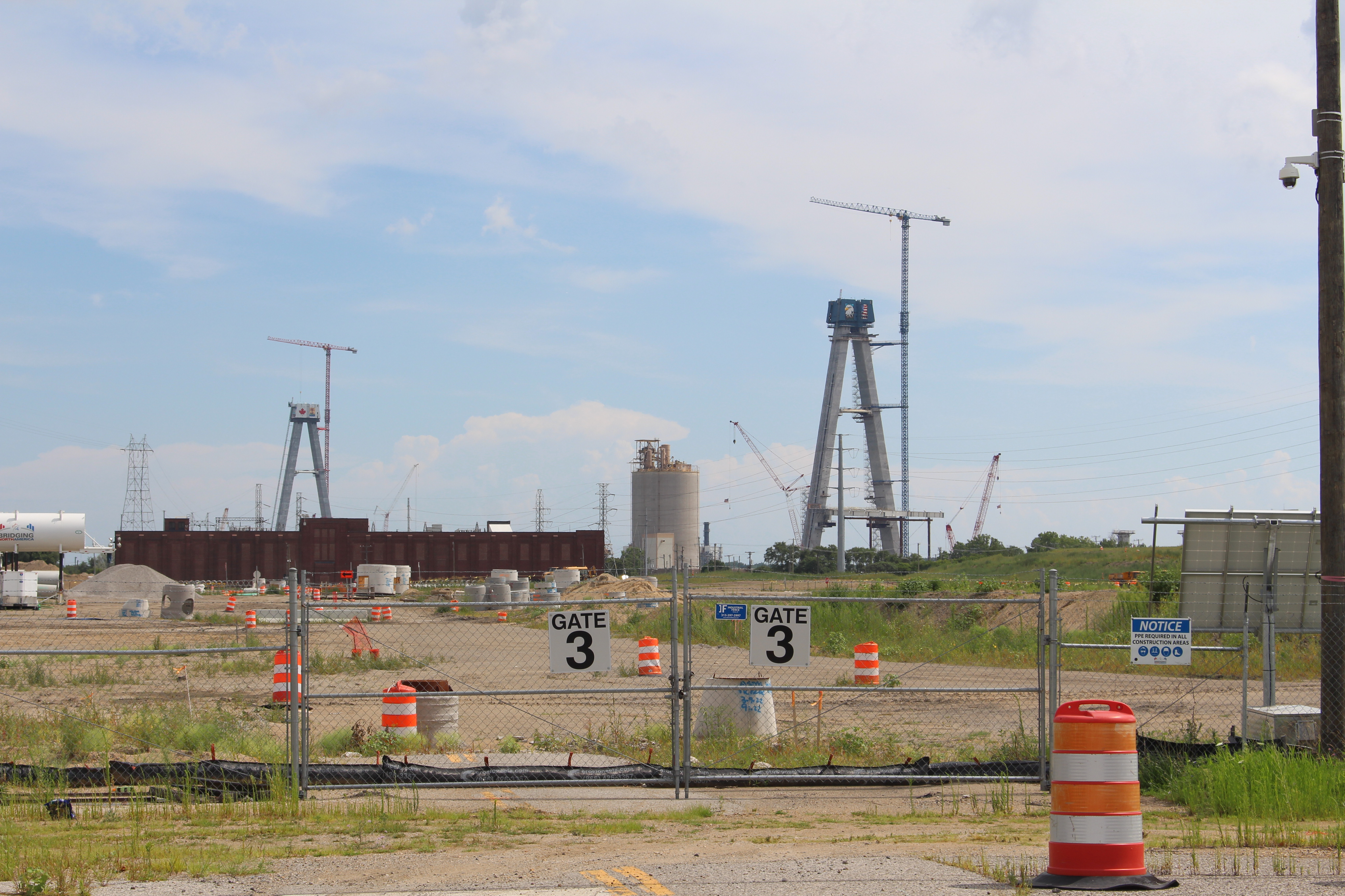
will feature A-shaped pylons that will stand 722 ft (220 m) tall, plus a center span of about 2,800 ft (853 m). First proposed in 2004 as a means of supplementing the already-existing Detroit River crossings in the area (the Ambassador Bridge and Detroit-Windsor Tunnel), the project has gone through years of legal challenges and environmental review. The existing Ambassador Bridge carries approximately 25% of all commercial merchandise trade between the USA and Canada, and the need for a new crossing in the area to relieve the pressure on the bridge has been apparent for several decades.

Under the guidance and ownership of the Windsor-Detroit Bridge Authority, a joint venture contracting team was selected for the project in 2018. Titled “Bridging North America”, this team consists of world-renowned engineering and construction firms such as AECOM (lead design firm), Dragados, Fluor, and Aecon (not to be confused with the above "AECOM") (construction contracting companies). The more than $4 billion USD project got underway in 2019 with significant land clearing for the Ports of Entry and bridge approach roadways and was originally expected to open to traffic in late 2024. Recent developments and progress updates have pushed that forecasted opening to 2025 as of September 2023.


Above: The American tower of the new Gordie Howe International Bridge takes shape in these August 2022 aerial photos

Above: The different one year makes! Here we see similar angles of the construction in these aerial photos from September 2023

Among the perks of this project are new and more modern Port of Entry facilities on both sides of the Detroit River, plus direct freeway-to-freeway access between Interstate 75 in Detroit and Highway 401 in Windsor. The existing crossings between the two countries currently rely on tedious local street connections in order to make the connection to the regional freeway networks on both sides of the border. By locating the new bridge where they have, officials on both sides of the border are aiming to increase the efficiency of this international crossing and remove excess commercial traffic from the local street grids of the two cities involved. Having said all of this, it is the strong opinion of the author of this article that both existing crossings should be kept open and maintained following the completion of the new bridge. The need for cross-border redundancy is necessary now more than ever, and the Ambassador Bridge especially is more than capable of serving admirably as a sort of “back-up” facility in the years ahead. (A recent deck replacement project was completed for this bridge in 2021 and the bridge is in otherwise very good condition.)

The new bridge being built here is named for long-time National Hockey League (NHL) star forward Gordie Howe, who’s illustrious Hall of Fame career included 25 years as a player for the local Detroit Red Wings. Howe led the Wings to four Stanley Cup championships during his tenure in Detroit and was a 23-time NHL All Star across a career that lasted an unequaled 32 seasons (interrupted by a brief retirement following the 1970-71 season). This, combined with his legendary career statistics and stature within North American professional hockey, earned him the nickname of “Mr. Hockey” throughout the continent. It is perhaps only fitting that a bridge of such towering dimensions be named for such a towering figure in his sport on both sides of the border.

As a civil engineer who has worked on large-scale bridge projects over the course of his career, this project in Detroit is one I’ve taken a strong interest in ever since its proposal and contract award. It’s a project that will be continued to be followed in the Dan household over the coming years and its one I look forward to see completed in due course. The following pictures of the construction were taken in August 2022 from ground level from the American side of the project. Click on each image to see a larger version.


The following pictures of the construction were taken in August 2022 from the air from the American side of the project. A DJI quadcopter drone was utilized for these images. This area of South Detroit offers ample opportunity to take in the scale of this project from the air, but please remember to do so safely and within the means of your experience and equipment level. Click on each image to see a larger version.
 

The following pictures of the construction were taken in September 2023 from ground level from the American side of the project. Click on each image to see a larger version.


The following pictures of the construction were taken in September 2023 from the air from the American side of the project. A DJI quadcopter drone was utilized for these images. This area of South Detroit offers ample opportunity to take in the scale of this project from the air, but please remember to do so safely and within the means of your experience and equipment level. Click on each image to see a larger version.


The following pictures of the construction were taken in September 2023 from ground level from the Canadian side of the project. Click on each image to see a larger version.


The following pictures of the construction were taken in September 2023 from the air from the Canadian side of the project. A DJI quadcopter drone was utilized for these images. This area of South Windsor offers ample opportunity to take in the scale of this project from the air, but please remember to do so safely and within the means of your experience and equipment level. Click on each image to see a larger version.


Less exciting, yet just as important for the project, is the construction of new Port of Entry facilities on both sides of the bridge, plus the connecting roadways and interchanges that will connect the bridge with the freeway systems of the USA and Canada.

The following pictures of the construction were taken in September 2023 from the air from the American side of the project. Included in this set is the American Port of Entry complex and the "Michigan Interchange", connecting the bridge with Interstate 75 near mile marker 46. A DJI quadcopter drone was utilized for these images. This area of South Detroit offers ample opportunity to take in the scale of this project from the air, but please remember to do so safely and within the means of your experience and equipment level. Click on each image to see a larger version.


The following pictures of the construction were taken in September 2023 from the air from the Canadian side of the project. Included in this set is the Canadian Port of Entry complex and the roadway connection to the western terminus of Highway 401. The westernmost 7 miles (10 km) of this freeway, which connects the Detroit/Windsor area of southern Ontario with greater Toronto, was completed in 2015 as the "Herb Gray Parkway". This highway extension was a preliminary project developed as part of the larger vision for the new bridge and its connecting infrastructure network, and will be covered in a separate forthcoming blog article. A DJI quadcopter drone was utilized for these images. This area of South Windsor offers ample opportunity to take in the scale of this project from the air, but please remember to do so safely and within the means of your experience and equipment level. Click on each image to see a larger version.


How to Get There:


Comments

Popular posts from this blog

Former US Route 50 and the Pioneer Route Lincoln Highway on Johnson's Pass Road

Johnson's Pass Road is one of the oldest highway corridors in California.  Johnson's Pass was part of the Lake Tahoe Wagon Road as it was completed during 1856 over the Sierra Nevada.  The pass would later be incorporated into the Pioneer Branch of the Lincoln Highway in 1913 and US Route 50 in 1926.  Johnson's Pass Road would be bypassed by a new alignment of US Route 50 over Echo Summit in 1938.  A replacement of the Meyers Grade east of Johnson's Pass would be opened to traffic in 1947.   Johnson's Pass Road remains accessible to traffic and is still signed by the Lincoln Highway Association.  Pictured as the blog cover is the view from the top of Johnson's Pass Road overlooking modern US Route 50 and Lake Tahoe.   Part 1; the history of Johnson's Pass Much of the history of what become the Lake Tahoe Wagon Road is discussed in the  September 1950 California Highways & Public Works  during its Centennial Edition.  The or...

Former US Route 50 and the South Lincoln Highway from Folsom east to Placerville

The corridor of Folsom of Sacramento County east to Placerville of El Dorado County has been a long established corridor of overland travel dating back to the California Gold Rush.  The Folsom-Placerville corridor was once part of the path of the Lake Tahoe Wagon Road which became the first California State Highway and later the South Lincoln Highway.  In time the South Lincoln Highway's surface alignment was inherited by US Route 50.  The Folsom-Placerville corridor also includes the communities of; Clarksville, Shingle Springs and El Dorado. Part 1; the history of the Lake Tahoe Wagon Road, South Lincoln Highway and US Route 50 through Folsom-Placerville Folsom is located on the American River/Lake Natoma of eastern Sacramento County.  That lands now occupied by the City of Folsom were part of Rancho Rio de los Americanos prior to the finding of gold at Sutter's Mill during 1848.  During the California Gold Rush the lands of Rancho Rio de los Americanos were p...

Old NC 10 - The Central Highway: Old Fort to Black Mountain through the Royal Gorge

A unique way of tracing the remnants of the Central Highway is through the mountainous terrain of Eastern Buncombe and Western McDowell Counties.  From the east on US 70, you reach the base of Blue Ridge Mountains at the town of Old Fort.  Old Fort is a tiny rail town that the old Central Highway and now US 70 goes through.  The Central Highway can be followed via a right onto Mill Creek Road from US 70.  Follow the highway as it takes you closer to the mountains.  When Mill Creek Road bears right to head towards Andrews Geyser stay straight until the road ends at a gate.  The nearby Piney Grove Church can be used for parking.  At this point, the old Central Highway began a 3.5 mile climb of the mountain to Swannanoa Gap.  NC 10 and later US 70 travelers followed this road for over 30 years until a new and modern four lane US 70 was built to the south.  This same four lane road would eventually become Interstate 40.    The Centra...