Springfield, TN Walkabout


Springfield is a community of about 18,000 and the seat of Robertson County.  It sits about an hour north of Nashville - allowing for the benefits of a small town but close enough to travel to and enjoy the luxuries of a large city.

Springfield was chartered as the Robertson County seat by the newly formed Tennessee General Assembly in 1796.  The town was laid out and established two years later; however, Springfield would not incorporate as a town until 1819.

Woodard Hall, built in 1899, is one of Downtown Springfield's oldest buildings.

Springfield was laid out on 50 acres of land.  The town included a public square, ten streets, and 66 lots available for purchase at $8/each.  The Springfield Public Square is where the Robertson County Courthouse sits today.

Roberston County Courthouse Clock Tower.

The current Robertson County Courthouse was constructed in 1879 with additions that included the clock tower built in 1929.  Since 1978, the courthouse has been on the National Register of Historic Places.


For decades, Springfield was known for its agriculture, specifically tobacco.  The community celebrated its notoriety as the home of the "World's Finest Dark Tobacco."  During the early and mid-20th century, a lit sign arched over US 41 (Dixie Highway) that boasted Springfield's claim.  Today, a building mural honors that sign.

116/118 6th Ave West in Springfield's Courthouse Square

Like many small towns throughout the country, Springfield's Downtown has numerous historic buildings.  About ten years ago, during the restoration of 116 & 118 6th Avenue West - developers came across a window transom with a unique design.  Through research, the building restoration crew discovered that the glass prism design was done by a young Frank Lloyd Wright when he was a designer at the Luxfer Prism Company in 1895.  The tiles and entire transom have been restored and are now prominently featured.

The restored transom featuring the Frank Lloyd Wright designed prisms.

Springfield has numerous local restaurants in and around town.  My personal favorite is Willie Mae's Barbecue, located at 200 8th Avenue East.  The town's local BBQ spot - Willie Mae's is run by a husband and wife team that serves lunch Tuesday through Fridays from 11:00 to 2:30 pm or - if it's a busy day - even earlier when they run out of food!
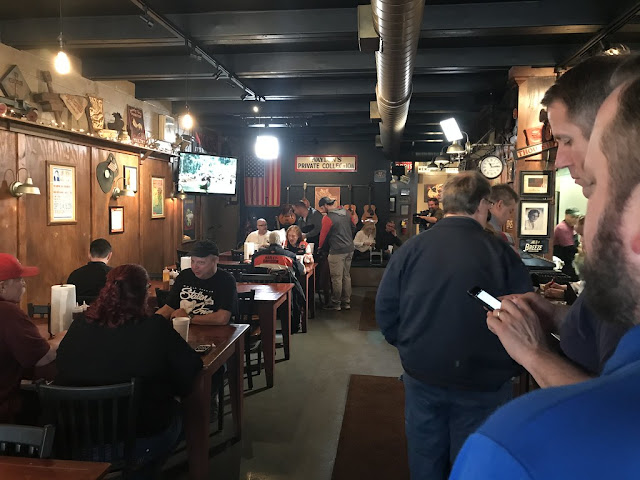
Lunch time at Willie Mae's.

The brisket is delicious, and my personal favorite is adding their BBQ sauce to the mac 'n cheese side.  You are always served with a friendly smile, and you'll always want to come back for more.

All photos taken by post author.

Further Reading:

How To Get There:

Comments

Popular posts from this blog

Paper Highways: The Unbuilt New Orleans Bypass (Proposed I-410)

  There are many examples around the United States of proposed freeway corridors in urban areas that never saw the light of day for one reason or another. They all fall somewhere in between the little-known and the infamous and from the mundane to the spectacular. One of the more obscure and interesting examples of such a project is the short-lived idea to construct a southern beltway for the New Orleans metropolitan area in the 1960s and 70s. Greater New Orleans and its surrounding area grew rapidly in the years after World War II, as suburban sprawl encroached on the historically rural downriver parishes around the city. In response to the development of the region’s Westbank and the emergence of communities in St. Charles and St. John the Baptist Parishes as viable suburban communities during this period, regional planners began to consider concepts for new infrastructure projects to serve this growing population.  The idea for a circular freeway around the southern perimeter of t

Huey P. Long Bridge (New Orleans, LA)

Located on the lower Mississippi River a few miles west of New Orleans, the Huey P. Long Bridge is an enormous steel truss bridge that carries both road and rail traffic on an old-time structure that is a fascinating example of a bridge that has evolved in recent years to meet the traffic and safety demands of modern times. While officially located in suburban Jefferson Parish near the unincorporated community of Bridge City, this bridge’s location is most often associated with New Orleans, given that it’s the largest and most recognizable incorporated population center in the nearby vicinity. For this reason, this blog article considers the bridge’s location to be in New Orleans, even though this isn’t 100% geographically correct. Completed in 1935 as the first bridge across the Mississippi River in Louisiana and the first to be built in the New Orleans area, this bridge is one of two bridges on the Mississippi named for Huey P. Long, a Louisiana politician who served as the 40th Gove

Legacy of US Route 466 Part 5: Old Highway 58 through North Barstow

Old Highway 58 is a relinquished portion of what was once US Route 466 in the North Barstow area.  US Route 466 served the North Barstow area from 1933 until it was truncated to Baker during June 1964.  The segment would become the easternmost portion of California State Route 58 which remained as an active highway until 1996 when freeway south of downtown Barstow opened.  Old Highway 58 has numerous remaining Caltrans signs and more or less functions as an alternative northern bypass of downtown Barstow.   US Route 466 can be seen branching from US Route 91 in North Barstow on the 1953 United States Geological Survey Map. Part 1-Part 4 of the US Route 466 Legacy Series can be found below: Legacy of US Route 466 Part 1: California State Route 46 Legacy of US Route 466 Part 2: Tehachapi to Bakersfield  Legacy of US Route 466 Part 3: Morro Bay to Shandon via Rocky Canyon Legacy of US Route 466 Part 4: Hoover Dam Part 1; the history of US Route 466 and California State Route 58 in North B