
Lynchburg, VA's College Lake Dam Removal Project Approaches Significant Milestone


It's not often that you hear about the planned removal of a dam in an urban area, but that's exactly the kind of project that the independent city of Lynchburg, VA has embarked on. The city and the University of Lynchburg are nearing the midway point of a lengthy project intended to reimagine the Blackwater Creek watershed in the area of the nearby University, while also replacing a structurally-problematic earthen dam and creating a newer, safer alignment for the local highway that currently crosses it.

The existing College Lake Dam was built in 1934 and impounds Blackwater Creek to form College Lake, which has a surface area of about 17 acres along the western periphery of the University campus. The dam additionally serves as the embankment that carries Lakeside Drive (US Route 221) across College Lake and the Blackwater Creek. The dam itself was built of compacted clay and stands 35 ft tall and is about 300 ft long. At the east end of the dam is a spillway for Blackwater Creek that is bridged by a single-span concrete & stone masonry arch. Severe flooding of College Lake due to record rainfall in August 2018 overtopped the dam and nearly caused its collapse; this incident prompted local and state officials to consider the dam’s removal as part of a larger restoration of Blackwater Creek and updating of the Lakeside Drive corridor.


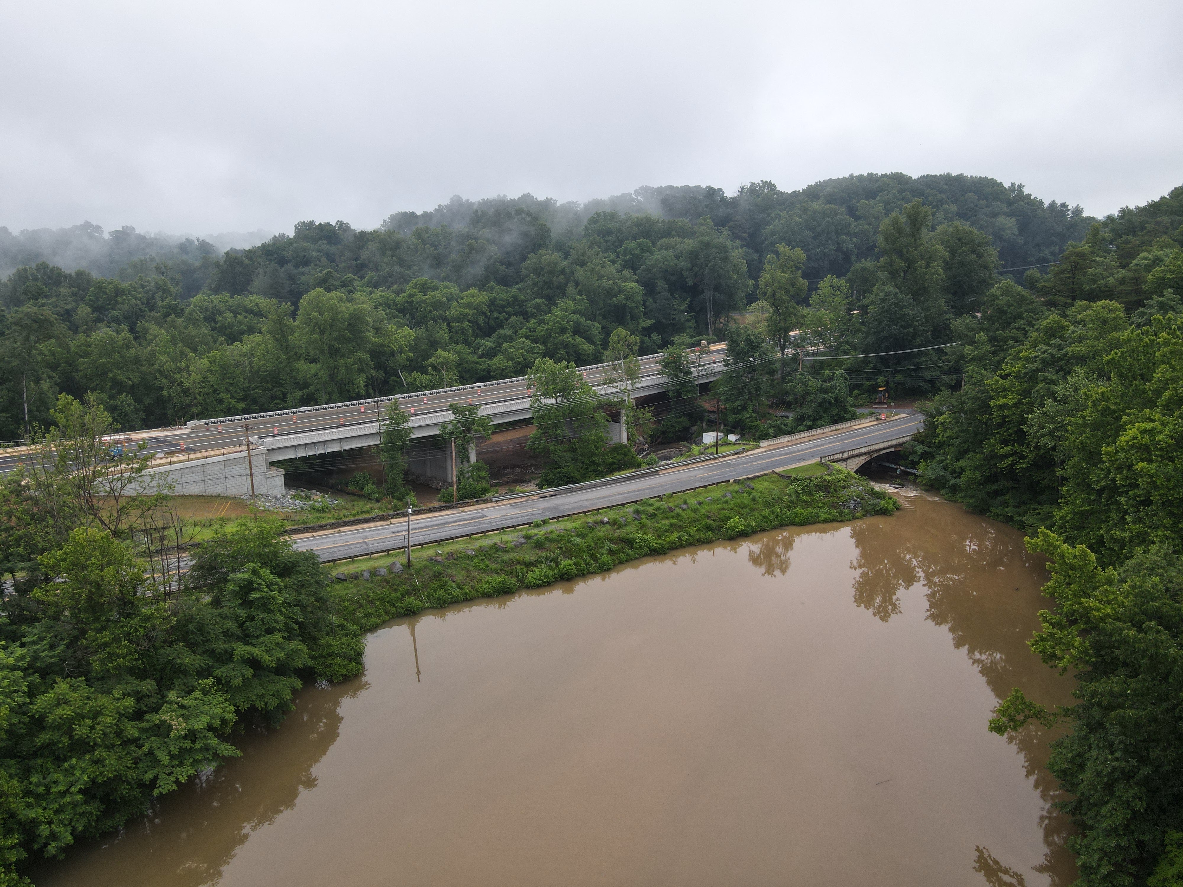
Above: The College Lake Dam is an earthen embankment that impounds Blackwater Creek near the University of Lynchburg to form College Lake
Below: The new four-way roundabout intersection at the main entrance to the University nears substantial completion

With the City and University in agreement that the safety and ecology of the College Lake area needed to be addressed, the first step in the construction process (which began in 2021 and is not expected to wrap up until 2024) is the construction of a four-lane bypass bridge to carry Lakeside Drive across Blackwater Creek a short distance downstream (north) of the dam site. As part of the bridge project, a new four-way roundabout intersection is being constructed at the east end of the new bridge in order to better and more efficiently serve access to the University of Lynchburg’s main entrance. Upon completion of the bridge in Summer 2022, work will begin on the removal of the College Lake Dam and the restoration of the surrounding ecosystem and wetlands to what local officials hope will be pre-dam conditions. Local officials are optimistic that this urban wetland restoration effort (which has a price tag of about $18 million) will not only provide ecological uplift and water quality benefits for the Blackwater Creek watershed, but will additionally serve as a model for future urban wildlife restoration efforts to be considered by municipalities nationwide.

The following pictures (from June 2022) of the old alignment of Lakeside Drive (US Route 221) were taken by the author of this post. Click on each photo to see a larger version.


The following ground-level pictures (from June 2022) of the new alignment of Lakeside Drive (US Route 221) were taken by the author of this post. Click on each photo to see a larger version.

The following aerial pictures of the construction site (from June 2022) were taken by the author of this post using a DJI quadcopter drone. Always use proper judgment and situational awareness when flying in areas such as this. Click on each photo to see a larger version.


How to Get There:


Comments

Popular posts from this blog

2018 Mojave Road Trip Part 2; The deadly desert highway (California State Route 127 and Nevada State Route 373)

After leaving Barstow via Old Highway 58 my next destination was in Death Valley.  To access Death Valley from rural San Bernardino County required a trek on north on Interstate 15 to California State Route 127 which becomes Nevada State Route 373 at the state line. Along I-15 I encountered the road sign oddity that is Zzyzx Road about eight miles south of Baker.   Zzyzx Road is a four mile road that used to go to the Zzyzx Mineral Springs and Health Spa.   The spa was founded in the 1940s and the owner made up the name "Zzyzx" to claim it was the last word in the English Language.  The spa has been shut down since the 1970s and is now part of a Desert Studies Center for California State University. The southern terminus of CA 127 in Baker is located at I-15 exit 246.  CA 127 is a 91 mile north/south highway which runs to the Nevada State Line in Inyo County.  CA 127 is called Death Valley Road from I-15 northward.  South of CA 127 ...

Finding the Pre-Emption Road of New York State

  The Pre-Emption Road (or rather a series of roads named Pre-Emption Road) follows a survey line called the Pre-Emption Line, drawn in the early days of the United States. The story begins with Massachusetts and New York having competing land claims to modern day Western New York State that have their roots in colonial charters granted by the British. After the Revolutionary War ended, this land became the frontier of the nation and its settlement became a priority for the new American government. During this era, there were a lot of competing land claims that needed to be settled. It was no different with the land claims between New York State and Massachusetts. On November 30, 1786, Massachusetts and New York sent representatives to Hartford, Connecticut to resolve their competing land claims. In less than three weeks, the representatives had reached a compromise. Massachusetts would receive pre-emption rights, meaning the right to sell the land after the Indian title ...

What's In a Name?: When the Roads Really Do Tell a Story

  Our tagline on the Gribblenation blog is "because every road tells a story". Some roads tell different stories than others. Along our travels, we may see historic markers that tell us a little story about the roads we travel or the places we pass by. Some historic markers are more general, as to telling us who lived where or what old trail traversed between two towns. During my travels across New York State and other states or provinces, I pass by many historic markers, some with interesting or amusing references to roads. I wanted to highlight a few of the markers I've seen along my travels around the Empire State and help tell their stories. Those stories may be as specific as explaining the tales of a tree that was used to help measure a distance of eight miles from Bath to Avoca in Steuben County, as referenced on the Eight Mile Tree historical marker above. They may also help point the way along historical roads first used centuries ago, or may help tell a local l...