Chualar is small community located in Salinas Valley of Monterey County, California. Modern US Route 101 is aligned through Chualar via a freeway bypass in what was once a Southern Pacific Railroad switching yard. The original alignment of US Route 101 in Chualar was aligned directly through the community on Grant Street. Above the cover photo of this blog features a view on the Chualar Freeway of US Route 101 shortly after it was completed during 1958. Below Chualar can be seen along US Route 101 on the 1935 Division of Highways Map of Monterey County.
Part 1; the history of US Route 101 in ChualarChualar was settled in 1871 in Salinas Valley along what was to become the coastal line of the Southern Pacific Railroad. Post Office Service briefly disbanded in Chualar during 1873 but would resume in 1874. During the 1880s when the Southern Pacific Railroad began to expand south towards Cuesta Pass the community of Chualar began to grow. Unlike many of the nearby communities in Salinas Valley the community of Chualar would never incorporate as a city. Chualar can be seen plotted along the Southern Pacific Railroad on the 1882 Bancroft's Map of California and Nevada. Unlike the Spanish El Camino Real the Southern Pacific Railroad corridor in Salinas Valley largely followed the best grade through the valley center.
Salinas Valley was ultimately part of the
American El Camino Real which began being signed as an Auto Trail starting in 1906. The era of State Highway Maintenance through Salinas Valley would ultimately begin with the 1909 First State Highway Bond Act which was approved by voters in 1910. One of the highways approved through the 1909 First State Highway Bond Act was a 481.8-mile highway originating at the City Limits of San Francisco which terminated in San Diego. This highway would ultimately come to be known in time as
Legislative Route Number 2 ("LRN 2"). Within Salinas Valley much of LRN 2 would follow the existing corridor along the frontage roads of the Southern Pacific Railroad which included the community of Chualar.
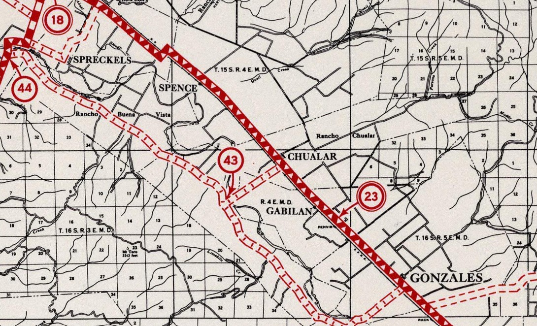
Chualar can be seen on the
1917 California State Automobile Association Map along LRN 2. LRN 2 can be seen taking a jog into Chualar via what was likely part of Chualar River Road onto Grant Street to avoid the Southern Pacific Railroad switching yard and reservation.
The initial draft of the US Route System was approved by the Secretary of Agriculture during November of 1925. The US Route System within California was approved by California Highway Commission with no changes recommended by
January 1926. The initial alignment of US Route 101 ("US 101") was planned to follow LRN 2 from San Francisco to San Diego via Salinas Valley. US 101 is shown on a map published in the 1926 California Highways & Public Works following LRN 2 south from San Francisco towards San Diego.
During November of 1926 the US Route System was approved by the ASSHO. US Route 101 can be seen aligned through Chualar on the
1926 Rand McNally Junior Map of California.
The
January/February 1929 California Highways & Public Works notes US Route 101/LRN 2 was between Salinas-Chualar was slated to be reconstructed during the 1929-31 Fiscal year. The volume notes the reconstruction of Salinas-Chualar corridor of US Route 101/LRN 2 included a railroad overhead.
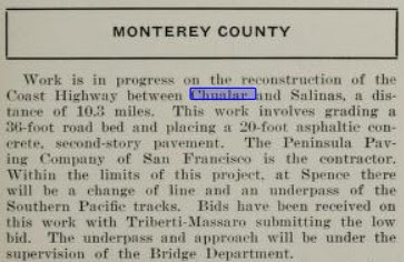
The
July/August 1929 California Highways & Public Works details the reconstruction of the Salinas-Chualar corridor US Route 101/LRN 2. The Salinas-Chualar corridor is project is stated to be planned to widen US Route 101/LRN 2 to a 36-foot roadbed and would eliminate a railroad crossing at Spence siding via an underpass structure.
The
March 1933 California Highways & Public Works announced reconstruction of US Route 101/LRN 2 from Chualar to Camphora was underway. The existing highway is stated to be too narrow and breaking apart too quickly.

The 1935 Division of Highways Map of Monterey County displays US Route 101/LRN 2 aligned through Chualar via Grant Street.
The May/June 1951 California Highways & Public Works notes US Route 101/LRN 2 between Spence Underpass-Chualar was to be graded and paved with a Portland Cement surface.
The
January/February 1952 California Highways & Public Works details the expansion of US Route 101/LRN 2 from Spence Underpass to Chualar to a four-lane expressway. The Spence Underpass-Chualar Expressway segment of US Route 101/LRN 2 is cited as opening on November 30th, 1951. The new northbound lanes of US Route 101/LRN 2 between Spence Underpass-Chualar were stated to be pressed into service early to provide relief to traffic while the southbound lanes were being modernized. The article notes the corridor of LRN 2 through Chualar had been first constructed to State standards during 1916.
The
July/August 1958 California Highways & Public Works announced the completion of the US Route 101/LRN 2 freeway through Chualar. The Chualar Freeway corridor is stated to have broken ground during April 1957 and took approximately a year to complete. The former corridor of US Route 101 on Grant Street is stated to have been converted to a frontage road of the new Chualar Freeway.
Since the completion of the freeway grade during 1958 there has been no major alterations to US Route 101 in Chualar. The Legislative Route Numbers were dropped as part of the 1964 State Highway Renumbering which left US Route 101 as the legislative designation through Chualar.
Part 2; a drive on former US Route 101 in Chualar
From modern US Route 101 northbound traffic can access the original alignment of the highway via Exit 317 onto Grant Street.
The former alignment of US Route 101 on Grant Street passes through Chualar for approximately a mile before looping back into the northbound lanes of the current freeway. Notably Main Street can be accessed from Grant Street via a freeway overpass. The Main Street overpass accesses a rail crossing which was the site of a deadly bus accident which occurred on September 17th, 1963. Said bus accident killed 32 migrant farm workers and is cited to be the deadliest automobile accident in United States history by the National Safety Council.


Comments