
Kingston, NY's New Roundabout Intersection Gets High Marks from Travelers


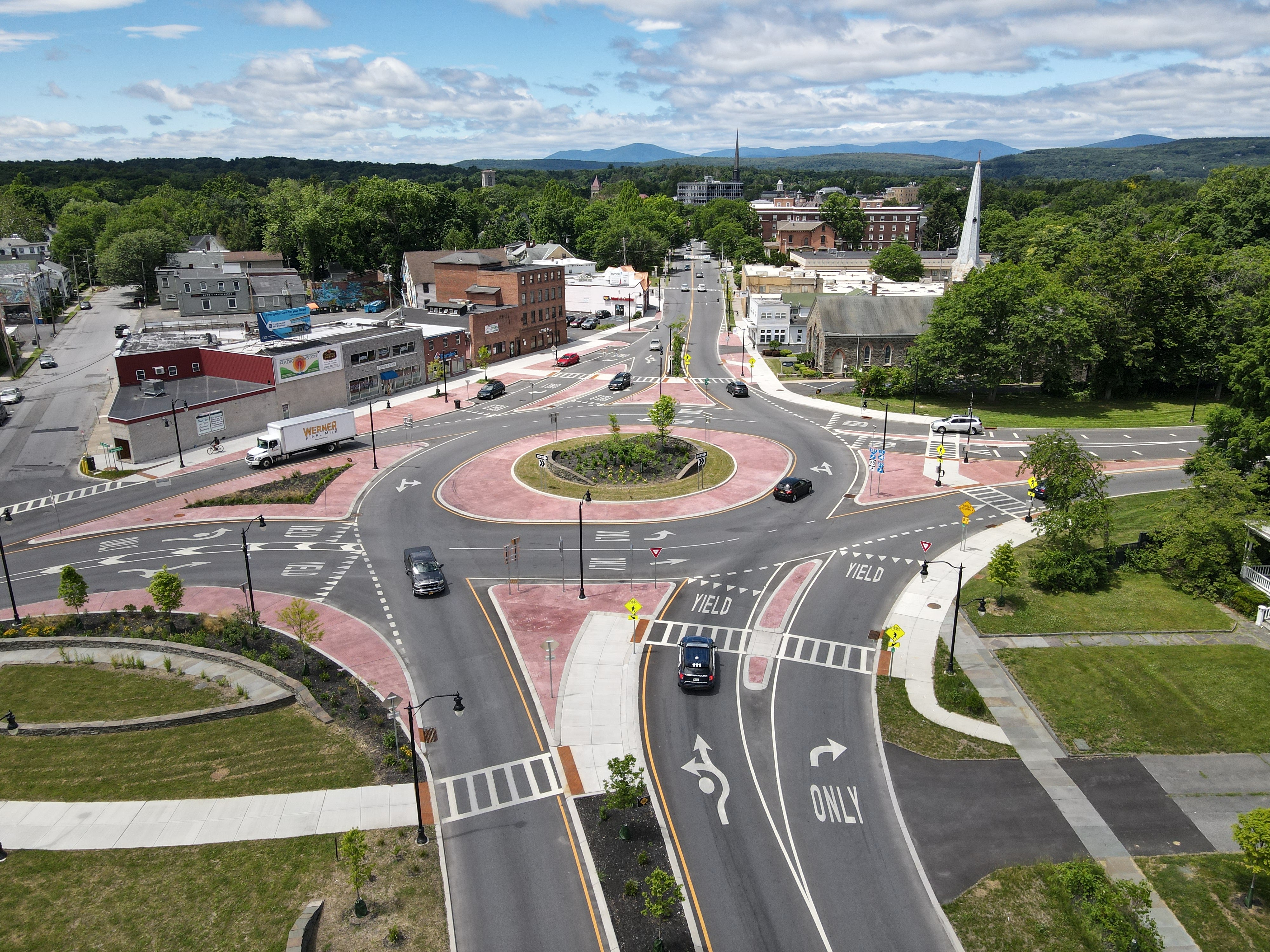
In what turned out to be a $12 million investment from the New York State Department of Transportation and the City of Kingston, NY, the four-way intersection connecting Broadway, Albany Avenue, and Interstate 587 was transformed into a much more efficient transfer point for traffic traversing western Kingston in all directions. The original four-way intersection here dated to the 1950s and its traffic signals were notoriously inefficient. Additionally, safe passage for pedestrians and other non-motorized traffic was no guarantee as those movements were not safely accounted for in the original design.


Above: The new Albany Avenue/Broadway Roundabout project increases efficiency of traffic movements across west Kingston while also improving motorist & pedestrian safety at one of the city's busiest intersections.

Construction of this $12 million project began in early 2020 and persevered throughout the COVID-19 Pandemic. Substantial completion status was attained at the end of 2021, with physical completion status being reached in Spring 2022. The new-look intersection has already had a significant impact on  travelers of all methods and has been a much needed investment for what had previously been one of Kingston's most outdated traffic transfer points.

The following pictures were taken by the author of this post using a DJI quadcopter drone. Always use proper judgment and situational awareness when flying in areas such as this. Click on each photo to see a larger version.


The following pictures were taken by the author of this post and detail some of the new traffic patterns and signage now in place at the new intersection:


Comments

Stephen Taylor said…
In Texas they're called traffic circles, and they're making a comeback. Austin is beginning to use them all over the city, including at a troublesome intersection near our home. The intersection has a large amount of north/south traffic, a steady amount of east traffic and very little from the west. Nasty intersection, controlled only by four stop signs. The COA installed the new traffic circle, and the intersection is now a joy to navigate. The traffic backups from the north continue, but traffic continues to flow and the backups move very quickly. The circle is very small, but it works very, very well. A good use of taxpayer money. Austin is also placing small circles in neighborhoods around town. My wife, who moved to Texas from Chicago, had never seen one and had to be taught how to use them. )She also had to be taught about low-water crossings and flash floods, but that's another story.)

My hometown had a large one where one east/west highway forked to the southwest and the northwest. TxDot installed a circle there back in the '50. Kids growing up in that town learned to navigate "The Circle" as it was called, very early on. It worked very well for my hometown, but when traffic circles fell out of favor with TxDot, the circle was replaced by a very awkwardly designed intersection with traffic signals. The locals hate that intersection with the white-hot heat of a thousand burning suns and wish they had their old circle back. They were all over Southeast Texas, and even today, in places where the circles have been replaced, businesses will still advertise their location as being "on the circle".

Popular posts from this blog

2018 Mojave Road Trip Part 2; The deadly desert highway (California State Route 127 and Nevada State Route 373)

After leaving Barstow via Old Highway 58 my next destination was in Death Valley.  To access Death Valley from rural San Bernardino County required a trek on north on Interstate 15 to California State Route 127 which becomes Nevada State Route 373 at the state line. Along I-15 I encountered the road sign oddity that is Zzyzx Road about eight miles south of Baker.   Zzyzx Road is a four mile road that used to go to the Zzyzx Mineral Springs and Health Spa.   The spa was founded in the 1940s and the owner made up the name "Zzyzx" to claim it was the last word in the English Language.  The spa has been shut down since the 1970s and is now part of a Desert Studies Center for California State University. The southern terminus of CA 127 in Baker is located at I-15 exit 246.  CA 127 is a 91 mile north/south highway which runs to the Nevada State Line in Inyo County.  CA 127 is called Death Valley Road from I-15 northward.  South of CA 127 ...

Finding the Pre-Emption Road of New York State

  The Pre-Emption Road (or rather a series of roads named Pre-Emption Road) follows a survey line called the Pre-Emption Line, drawn in the early days of the United States. The story begins with Massachusetts and New York having competing land claims to modern day Western New York State that have their roots in colonial charters granted by the British. After the Revolutionary War ended, this land became the frontier of the nation and its settlement became a priority for the new American government. During this era, there were a lot of competing land claims that needed to be settled. It was no different with the land claims between New York State and Massachusetts. On November 30, 1786, Massachusetts and New York sent representatives to Hartford, Connecticut to resolve their competing land claims. In less than three weeks, the representatives had reached a compromise. Massachusetts would receive pre-emption rights, meaning the right to sell the land after the Indian title ...

What's In a Name?: When the Roads Really Do Tell a Story

  Our tagline on the Gribblenation blog is "because every road tells a story". Some roads tell different stories than others. Along our travels, we may see historic markers that tell us a little story about the roads we travel or the places we pass by. Some historic markers are more general, as to telling us who lived where or what old trail traversed between two towns. During my travels across New York State and other states or provinces, I pass by many historic markers, some with interesting or amusing references to roads. I wanted to highlight a few of the markers I've seen along my travels around the Empire State and help tell their stories. Those stories may be as specific as explaining the tales of a tree that was used to help measure a distance of eight miles from Bath to Avoca in Steuben County, as referenced on the Eight Mile Tree historical marker above. They may also help point the way along historical roads first used centuries ago, or may help tell a local l...