This past Tuesday I took advantage of weather in the 70s to return to Pinnacles National Park for the first time in 2018.

Generally I go to Pinnacles National Park at least four or five times a year given it isn't a long drive. I was heading to the eastern part of Pinnacles National Park so that left me a choice of several routes to take over the Diablo Range. I took California State Route 198 over the Diablo Range which has a crest over Peach Tree Valley. Peach Tree Valley is boundary to the Gabilan Range in addition to being part of the San Andreas Fault.

CA 198 intersects CA 25 in Peach Tree Valley which is where the first signage indicating Pinnacles National Park is to the north is located.

CA 198 over the Diablo Range and CA 25 are two of the best drives in all of California. CA 198 has a ton of fun high speed mountain grades while CA 25 follows the San Andreas Fault north to US 101. I wrote two previous articles on both subjects previously which can be found at the links below.
CA 198 (US 101 east to I-5)
CA 25; the Airline Highway
Approaching the eastern segment of CA 146 the Pinnacles can actually be seen towering over the terrain.

The junction for the eastern segment of CA 146 directs traffic to Pinnacles National Park.


One of my goals of the day was to further look into the gap in CA 146. The eastern segment of CA 146 ends at the previous boundary for Pinnacles National Monument. CA 146 east starts at mile marker 15.15 at CA 25 and ends at mile marker 12.70 right in front of the old entrance station for Pinnacles National Monument.


I wrote two previous articles on CA 146 East and CA 146 West which can be found below.
CA 146 East
CA 146 West
CA 146 West traverses from US 101 to the Pinnacles National Park boundary in the Gabilan Range where it ends at Mile Marker 10.19. As I noted in the two above articles the 1935 San Benito County Road Map from the California Division of Highways shows that the previous designation of Legislative Route 120 ended in East Pinnacles at Bear Gulch. The mileage between both sides of CA 146 seems to be based on a direct line through Bear Gulch. The 1935 San Benito County Road map can be seen below.
1935 San Benito County Road Map
Something that I didn't noticed previously on the above map is that the road leading up to Bear Gulch doesn't appear to be within Pinnacles National Monument in 1935. That would certainly explain why the state adopted the entire road in 1933 into LRN 120 since it was direct access to a National Monument. It seems that by at least 1938 the terminus for the eastern segment of LRN 120 was cut back to the entrance station where CA 146 east ends today. The change can be seen on the 1935 State Highway Map.
1938 State Highway Map
My understanding is that in 1933 the Civilian Conservation Corps started to improve the Bear Gulch Area which included building the Bear Gulch Reservoir. The timing directly coincides with LRN 120 being established by the state. Apparently there was actually a significant number of mining claims in the area around Pinnacles National Monument that were eventually annexed in the park lands through the 1950s. I found this document by the USGS in 1987 which lists the known mining claims and when they were staked in what was the Pinnacles Wilderness and Pinnacles National Monuement.
1987 USGS Publication on Mineral Study of Pinnacles Area
So with all the above in mind this would have been the full extent of LRN 120 to Bear Gulch along the present Park Service Roads.


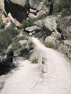
So with all the highway stuff out of the way the main attraction of the day was hiking over the Pinnacles. I had a goal of at least getting over the High Pinnacles Trail at least to the Condor Gulch Trail. I parked at Bear Gulch and made my way to the Bear Gulch Trail headed south towards the Bear Gulch Reservoir.

The Bear Gulch Trail follows Bear Gulch for 0.7 miles before reaching the Moses Spring Trail branches in two directions both which hear to the Bear Gulch Reservoir. The left trail goes through the Bear Gulch Cave while the right trail goes above it.


I wasn't sure if the Bear Gulch Cave was open but I figured it was worth a try and took the left branch of the Moses Springs Trail. After a short walk I made my way to the entrance of the Bear Gulch Cave.


The Bear Gulch Cave was partially flooded but I was able to make my way over the rocks. After about a quarter mile through the cave I encountered a locked gate and had to turn back. The Beach Gulch Cave is a Talus Cave which was created by boulders above Bear Gulch caving in. The Park Service requires a flash light but there was just enough light to see adequately, I did use my phone in places to light up objects in more detail.


After leaving the Bear Gulch Cave I made my way to the right branch of the Moses Spring Trail and ascended towards the Bear Gulch Reservoir. The right branch of the Moses Spring Trail crosses through the upper portion of the Bear Gulch Cave before approaching the dam at Bear Gulch Reservoir.


Bear Gulch Reservoir is a fairly small but the impounding of water makes for an odd backdrop among the rock spires overhead. I stopped briefly to check my map before continuing the Rim Trail northward.


The Rim Trail is fairly short and connects to the High Peaks Trail. There was a pretty good makeshift overlook of Bear Gulch climbing onto the top of a rock spire.

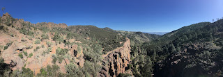

The High Peaks Trail ascends 1.5 miles to the Juniper Canyon Trail which connects to the western portion of Pinnacles National Park. The climb in elevation is significant but this particular portion of the High Peaks Trail is very easy and well maintained.


The junction with the Juniper Canyon Trail is obvious from the outhouse building located overhead. The junction has a decent overlook of the western part of Pinnacles National Park. I stopped for a quick look before continuing north on the High Peaks Trail.


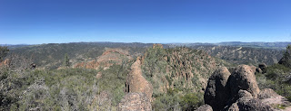
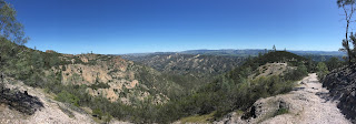
The High Peaks trail narrows at the top of the High Peaks Trail but is still plenty wide for several people. The only really difficult part is negotiating the extremely small stairwells which have railing. At the very top there is a wide vista of the eastern part of Pinnacles National Park, the San Andreas Fault, and Diablo Range.


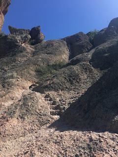


There are several more staircases on the descent off the top of the High Peaks Trail before it meets the Tunnel Trail.


I took the High Peaks Trail east towards the Condor Gulch Trail to get back to the Bear Gulch Area. Apparently it Bear Gulch was about 2.6 mile away, the Condor Gulch Trail is smooth enough I did some trail running to speed things along to get back to my car.


All told it took about 3.5 hours to get through all the trails described above. I can say with certainty that there was no way a through road could have been created through Bear Gulch given the talus cave that exists. To that end I think that the full backstory on CA 146 can finally be put to rest once and for all. I'm honestly surprised that the Park Service hasn't picked up maintenance on the entire eastern segment of CA 146 given the park boundary expanded when it became a National Park.

Generally I go to Pinnacles National Park at least four or five times a year given it isn't a long drive. I was heading to the eastern part of Pinnacles National Park so that left me a choice of several routes to take over the Diablo Range. I took California State Route 198 over the Diablo Range which has a crest over Peach Tree Valley. Peach Tree Valley is boundary to the Gabilan Range in addition to being part of the San Andreas Fault.

CA 198 intersects CA 25 in Peach Tree Valley which is where the first signage indicating Pinnacles National Park is to the north is located.

CA 198 over the Diablo Range and CA 25 are two of the best drives in all of California. CA 198 has a ton of fun high speed mountain grades while CA 25 follows the San Andreas Fault north to US 101. I wrote two previous articles on both subjects previously which can be found at the links below.
CA 198 (US 101 east to I-5)
CA 25; the Airline Highway
Approaching the eastern segment of CA 146 the Pinnacles can actually be seen towering over the terrain.

The junction for the eastern segment of CA 146 directs traffic to Pinnacles National Park.


One of my goals of the day was to further look into the gap in CA 146. The eastern segment of CA 146 ends at the previous boundary for Pinnacles National Monument. CA 146 east starts at mile marker 15.15 at CA 25 and ends at mile marker 12.70 right in front of the old entrance station for Pinnacles National Monument.


I wrote two previous articles on CA 146 East and CA 146 West which can be found below.
CA 146 East
CA 146 West
CA 146 West traverses from US 101 to the Pinnacles National Park boundary in the Gabilan Range where it ends at Mile Marker 10.19. As I noted in the two above articles the 1935 San Benito County Road Map from the California Division of Highways shows that the previous designation of Legislative Route 120 ended in East Pinnacles at Bear Gulch. The mileage between both sides of CA 146 seems to be based on a direct line through Bear Gulch. The 1935 San Benito County Road map can be seen below.
1935 San Benito County Road Map
Something that I didn't noticed previously on the above map is that the road leading up to Bear Gulch doesn't appear to be within Pinnacles National Monument in 1935. That would certainly explain why the state adopted the entire road in 1933 into LRN 120 since it was direct access to a National Monument. It seems that by at least 1938 the terminus for the eastern segment of LRN 120 was cut back to the entrance station where CA 146 east ends today. The change can be seen on the 1935 State Highway Map.
1938 State Highway Map
My understanding is that in 1933 the Civilian Conservation Corps started to improve the Bear Gulch Area which included building the Bear Gulch Reservoir. The timing directly coincides with LRN 120 being established by the state. Apparently there was actually a significant number of mining claims in the area around Pinnacles National Monument that were eventually annexed in the park lands through the 1950s. I found this document by the USGS in 1987 which lists the known mining claims and when they were staked in what was the Pinnacles Wilderness and Pinnacles National Monuement.
1987 USGS Publication on Mineral Study of Pinnacles Area
So with all the above in mind this would have been the full extent of LRN 120 to Bear Gulch along the present Park Service Roads.


So with all the highway stuff out of the way the main attraction of the day was hiking over the Pinnacles. I had a goal of at least getting over the High Pinnacles Trail at least to the Condor Gulch Trail. I parked at Bear Gulch and made my way to the Bear Gulch Trail headed south towards the Bear Gulch Reservoir.

The Bear Gulch Trail follows Bear Gulch for 0.7 miles before reaching the Moses Spring Trail branches in two directions both which hear to the Bear Gulch Reservoir. The left trail goes through the Bear Gulch Cave while the right trail goes above it.


I wasn't sure if the Bear Gulch Cave was open but I figured it was worth a try and took the left branch of the Moses Springs Trail. After a short walk I made my way to the entrance of the Bear Gulch Cave.


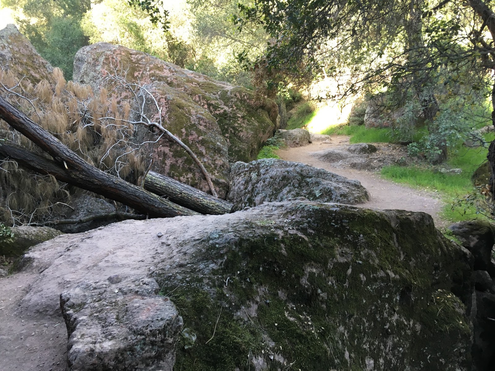


The Bear Gulch Cave was partially flooded but I was able to make my way over the rocks. After about a quarter mile through the cave I encountered a locked gate and had to turn back. The Beach Gulch Cave is a Talus Cave which was created by boulders above Bear Gulch caving in. The Park Service requires a flash light but there was just enough light to see adequately, I did use my phone in places to light up objects in more detail.


After leaving the Bear Gulch Cave I made my way to the right branch of the Moses Spring Trail and ascended towards the Bear Gulch Reservoir. The right branch of the Moses Spring Trail crosses through the upper portion of the Bear Gulch Cave before approaching the dam at Bear Gulch Reservoir.


Bear Gulch Reservoir is a fairly small but the impounding of water makes for an odd backdrop among the rock spires overhead. I stopped briefly to check my map before continuing the Rim Trail northward.


The Rim Trail is fairly short and connects to the High Peaks Trail. There was a pretty good makeshift overlook of Bear Gulch climbing onto the top of a rock spire.


The High Peaks Trail ascends 1.5 miles to the Juniper Canyon Trail which connects to the western portion of Pinnacles National Park. The climb in elevation is significant but this particular portion of the High Peaks Trail is very easy and well maintained.


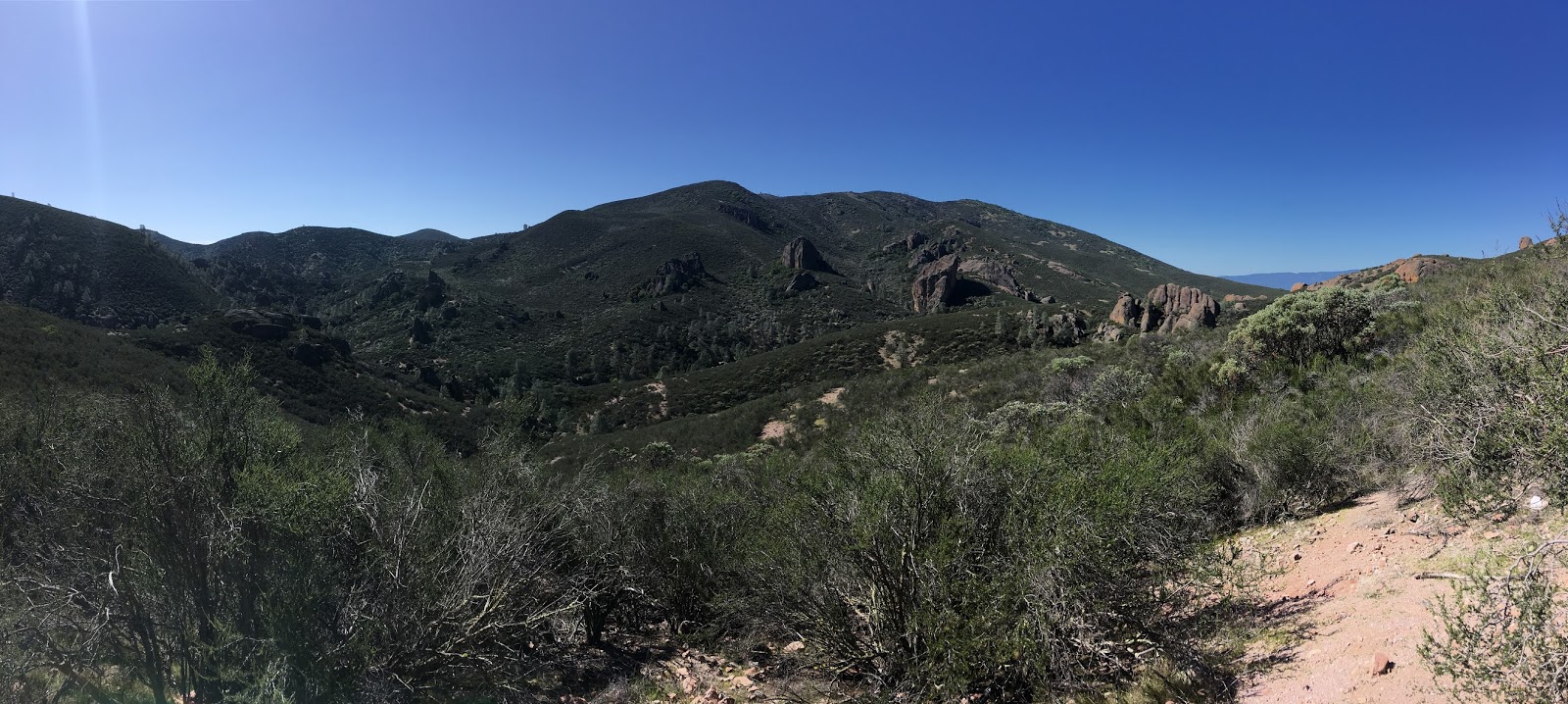


The junction with the Juniper Canyon Trail is obvious from the outhouse building located overhead. The junction has a decent overlook of the western part of Pinnacles National Park. I stopped for a quick look before continuing north on the High Peaks Trail.


The High Peaks trail narrows at the top of the High Peaks Trail but is still plenty wide for several people. The only really difficult part is negotiating the extremely small stairwells which have railing. At the very top there is a wide vista of the eastern part of Pinnacles National Park, the San Andreas Fault, and Diablo Range.


There are several more staircases on the descent off the top of the High Peaks Trail before it meets the Tunnel Trail.


I took the High Peaks Trail east towards the Condor Gulch Trail to get back to the Bear Gulch Area. Apparently it Bear Gulch was about 2.6 mile away, the Condor Gulch Trail is smooth enough I did some trail running to speed things along to get back to my car.


All told it took about 3.5 hours to get through all the trails described above. I can say with certainty that there was no way a through road could have been created through Bear Gulch given the talus cave that exists. To that end I think that the full backstory on CA 146 can finally be put to rest once and for all. I'm honestly surprised that the Park Service hasn't picked up maintenance on the entire eastern segment of CA 146 given the park boundary expanded when it became a National Park.
Comments