
This blog is part of the larger Gribblenation US Route 99 Page. For more information pertaining to the other various segments of US Route 99 and it's three-digit child routes check out the link the below.

Part 1; the history of US Route 99 in Fresno
That little US 99 sign above was the inspiration I needed to start tracking all the former alignments through the City of Fresno. Fresno in general has had a huge shift in highway layouts over the decades which is something I intend to finish with California 41 and 180 perhaps later this month. Based off my research I came with the following three maps progressing northward through Fresno showing every iteration of US 99 before it was downgraded to a State Highway in 1967.


What became US Route 99 in Fresno was adopted into the State Highway System as Legislative Route 4 in 1909. LRN 4 was legislatively defined as a 358 mile State Highway between Sacramento and Los Angeles. LRN 4 was one of many major the State Highways that was defined during the 1909 First State Highway Bond Act. The First State Highway Bond Act was approved by voters in 1910. While the Division of Highways could not maintain roadways until the legislature made it clear they could in 1933 the roads constructed as part of LRN 4 played a massive influence in how US 99 ended up being aligned through Fresno.
Before the US Route System was approved in Late 1926 the future alignment of US 99 through Fresno carried numerous Auto Trail designations. The 1920 Clason Highway Map of California shows the National-Park-to-Park Highway, the Inland Route, and National Roosevelt Midland Trail all on the future alignment of US 99 in Fresno.


The US Route System was finalized and approved in November 1926. Essentially the route alignment history of US Route 99 in Fresno is as follows.
1926-1930 Alignment
Progressing northward into Fresno US Route 99 would have followed:
- Railroad Avenue
- Cherry Avenue
- Broadway Street
- Divisadero Street
- H Street
- Belmont Avenue
- Golden State Avenue
1930-1934 Realignment off of Railroad Avenue
Sometime between 1930 to 1934 US Route 99 was realigned off of Railroad Avenue at Church Avenue. From Church Avenue US Route 99 progressed to Hazel which is now G Street and followed it to Cherry Avenue.
Note; the December 1931 California Highways & Public Works ("CHPW") Guide discusses the City of Fresno requesting the State assist in funding a subway on US 99 under the Southern Pacific Railroad tracks on Belmont Avenue.

The construction of the Belmont Subway was announced in the February 1932 CHPW Guide.

The completion of the Belmont Subway and Traffic Circle is discussed in the 1932 CHPW Guide. The Belmont Traffic Circle was the first of it's kind in California and a centerpiece of early US 99.


A clue to the realignment of US 99 onto Church Avenue and it's wider rail crossing approach is offered in the May-June 1933 CHPW Guide. The CHPW Guide cites that a 0.7 mile segment of LRN 4 between Church Avenue and California Avenue was to be paved with concrete. The contract to pave LRN 4 between Church Avenue and California Avenue is shown awarded to Union Paving Company.

1946-1948 Larger realignment off of Railroad Avenue
Sometime between 1946-1948 US Route 99 was realigned further southward off of Railroad Avenue onto G Street.
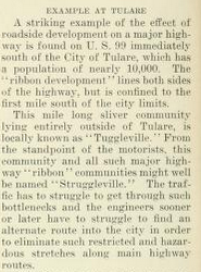
The March/April 1945 CHPW Guide discusses planned relocation of much of US 99 in the vicinity of Fresno onto a new separated grade. The CHPW goes into great deal discussing the number of accidents along US 99 in Fresno County due to the high number of road side businesses.


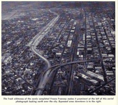
The new alignment of US 99 onto the "Fresno Freeway" (Golden State Boulevard) replacing Railroad Avenue south of Fresno is discussed in the November/December 1946 CHPW Guide.


1950 Realignment off of Cherry Avenue
By 1950 US Route 99 had been extended further north into Fresno away from Cherry Avenue on G Street and took a roadway that is located roughly where the California 41 freeway is to Broadway Street.
The early phases of the Southern Pacific overpass realignment of US 99 into downtown Fresno and the acquiring of parcels is discussed in the January/February 1948 CHPW Guide. The CHPW Guide goes into great detail through two articles regarding the relocation of a German Lutheran Church.


The October/November 1948 CHPW Guide cities that the new overpass over the Southern Pacific Railroad south of downtown Fresno was 60% complete. The same article cites that US 99 north of the Belmont Traffic Circle was being upgraded to four-lanes.

The new Southern Pacific Railroad crossing connecting Golden State Boulevard to Broadway is stated to have been opened to traffic on December 22, 1948 in the March/April 1949 CHPW Guide. The overpass structure is called the "Monterey Street Overhead" in the CHPW Guide.


1958 The downtown freeway is built
By 1958 the new (and current) freeway alignment of US Route 99 through downtown Fresno was completed. G Street was likely replaced at this time by Golden State Boulevard as an expressway on the south side of the city which connected to the new freeway.
The September/November 1954 CHPW Guide cites that US 99 within Fresno was in the process of being upgraded to a freeway.

The September/October 1955 CHPW Guide discusses the progress of US 99 being upgraded to a freeway through downtown Fresno.


The November/December 1957 CHPW Guide discusses the completion of the US 99 freeway alignment through downtown Fresno in October 1957.


1964 Golden State Boulevard is replaced
By 1964 US Route 99 was shifted onto a new freeway alignment on the south side of Fresno off of Golden State Boulevard. US Route 99 was renumbered as California State Route 99 in 1967 due to Interstate 5 being built in the western stretches of San Joaquin Valley.
The September/October 1962 CHPW Guide discusses the construction of the US 99 freeway south of Fresno.


Of course CHPW Guides wouldn't be all that fun without the accompanying Division of Highways Maps I used in my research.
1930 Division of Highways State Map City Insert

1934 Division of Highways State Map City Insert

1938 Division of Highways Map City Insert

1946 California State Highway Map City Insert

1948 Division of Highways State Map City Insert

1949 Division of Highways State Map City Insert

1950 Division Highways State Map City Insert

1957 Division of Highways State Map City Insert

1958 Division of Highways State Map City Insert

1963 California State Highway Map City Insert

1964 California State Highway Map City Insert

1967 Division of Highways State Map

Part 2; driving as many old US Route 99 alignments as I could find in Fresno
But really no amount of map or public guide research about historic alignments is complete without actually trying to drive a replicated route. My goal was to drive as much of the original 1926 alignment of US Route 99 in Fresno as I could. I just so happened to be a little further south in Fresno County so I took as much of what was US Route 99 north into the city of Fresno as I could. I started in Kingsburg where Simpson Street which was once part of US Route 99 now dead-ends at a cold storage facility.


Simpson Street is divided in Kingsburg, I would imagine at some point there was four-lanes of traffic instead of two. Given the now generous parking areas I was able to pull over and get a good picture of the Kingsburg Railroad Depot which was built in 1902.


The Kingsburg Railroad Depot was recently restored and the museum housed inside has a historic page.
Kingsburg Railroad Depot History
North of Sierra Street/California 201 is where Simpson Street blows out to an expressway, I believe it becomes officially signed as Golden State Boulevard at Stroud Avenue.


Northward entering the city of Selma US Route 99 would have used Whitson Street through the city. US Route 99 ran on an earlier alignment through Selma on West Front Street which connects to Whitson at both the south and north side of the city.


Stepping back to the earlier Front Street alignment of US 99 and LRN 4, it was far more direct but wouldn't have been able to facilitate expressway level traffic. Front Street essentially was a frontage road set up by the Central Pacific Railroad when it established Selma as a rail road siding in 1870s. Downtown Selma and Front Street can be seen as the main highway on this 1891 Thompson Map.

Selma was incorporated as a City in 1893. That being the case it isn't likely that US 99 would have been shifted off Front Street onto Whitson Street until after 1933 when State Highway funds were allowed to be used in cities. The Front Street alignment of US 99 headed northbound diverges from Whitson Street near Todd Street and rejoins it near Highland Avenue.


North of Selma the expressway opens up and again becomes Golden State Boulevard which remains as such all the way into Fresno.

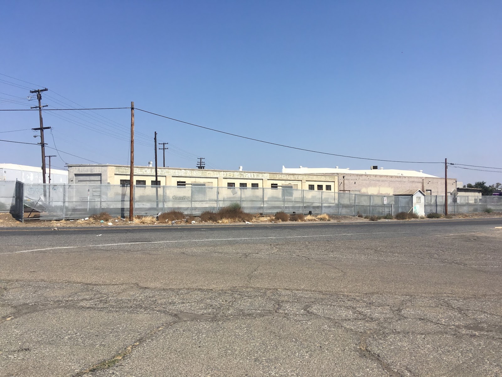
Golden State Boulevard bisects the city of Fowler as the main drag through town. Fowler has some interesting industrial buildings to look at from the northbound lanes, I'm to understand this old warehouse is still occupied by a company called FDS Manufacturing.


The original alignment of US 99/LRN 4 in Fowler was on 8th Street which was four lanes wide during it's peak use. The reason for US 99 used 8th Street in Fowler was the large switch set up by the Central Pacific in 1872 known as "Fowler's Switch."


Fowler's Switch can be seen on the 1891 Thompson Map of the community. Fowler's Switch existed over what is now the northbound lanes of Golden State Boulevard. Fowler's Switch appears to have been removed some time in the 1940s which lead to US 99 being realigned onto Golden State Boulevard as an expressway through Fowler.
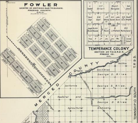
8th Street in Fowler is still intact between South Avenue north to Adams Avenue.


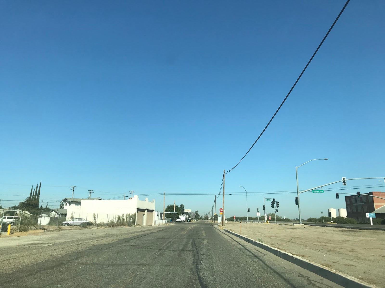
Between Fowler and the city limits of Fresno there are some interesting overpasses above Golden State Boulevard. The first overpass is Clovis Avenue while the second is Central Avenue.


Golden State Boulevard uses an overpass of North Avenue which is the city limit of Fresno.


The original alignment of US Route 99 through Fresno starts with a soft right off Golden State Boulevard onto Railroad Avenue.


Church Avenue is the location of the 1930-1934 realignment I cited above. At some point US Route 99 would have been shifted onto west Church Avenue to continue north on G Street. The original US Route 99 alignment continued directly north on Railroad Avenue ahead in the picture.

Ahead at the advisory sign is Cherry Avenue. In the original alignment of US Route 99 traffic would have taken a right turn onto Cherry over the railroad tracks. The 1930-1934 realignment also used Cherry but would have come in from the left.

Cherry Avenue no longer is continuous and is cut off by the railroad. You can almost see how the original US Route 99 would have entered downtown Fresno looking at the roadway ahead of the fence line.

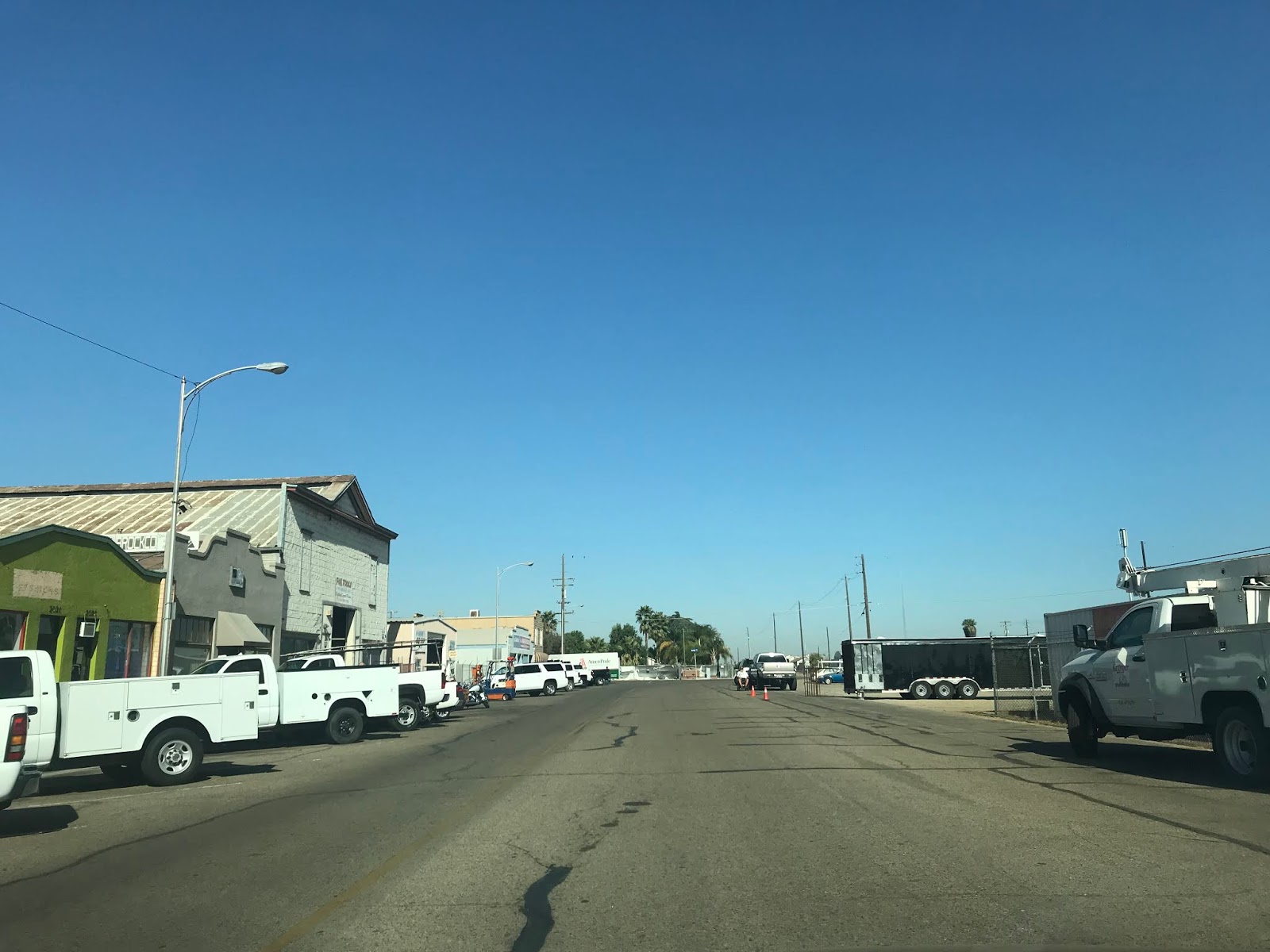
Looking back southward on Railroad Avenue from Cherry Avenue it is apparent how much the neighborhood and infrastructure has decayed. I'm to understand this particular neighborhood of Fresno is known as the Warehouse District, there is evidence of much better times with derelict street lamp posts and abandoned buildings.


As noted above US 99 was realigned from Railroad Avenue onto G Street where it approached the Southern Pacific Rails via Cherry Avenue. This realignment was intended to widen the approach to the rail crossing due to the heavy amounts of traffic backups. G Street still has numerous vintage motels that neon signage, although rumor has it they have fallen into seedier usage as of late.


The 1957 transition/realignment of US 99 on Golden State Boulevard to the downtown section of the Golden State Freeway still exists. From Cherry Avenue to CA 99/Golden State Freeway the alignment of Golden State Boulevard is actually a fully limited access freeway grade.


To continue on Cherry north of the railroad tracks I had to backtrack on Railroad Avenue to cross at Van Ness Avenue which passes the Van Ness Avenue Welcome Arch. The current Van Ness Avenue Welcome Arch was constructed in 1929 which replaced an earlier arch. The Arch was meant to attract travels into downtown Fresno but largely has fallen into neglect after receiving one restoration in the late 20th century. The High Speed Rail construction is slated to cut-off access across the tracks on Van Ness Avenue which makes the future of the Arch uncertain. I've heard rumors talking about the Arch being moved to Fulton Street when it reopens to traffic in October but nothing I can confirm.

Once I returned to Cherry Avenue I took it to Broadway Street passing a couple more tracks in the process.


At the corner of Cherry Avenue and Broadway there is an interesting site which contains the wreckage of two Fresno Traction Company streetcars. Starting in 1889 horse drawn streetcar service began in Fresno. In 1901 the three streetcar companies in Fresno consolidated as began operating electric lines beginning in 1903 at the Fresno Traction Company. The Fresno Traction Company operated electric street car service until 1939 when the lines were converted to bus service. Fresno Traction Company over time became the modern Fresno Area Express.


The larger car is a somewhat rare step-less Dragon Car which operated typically on weekends that had a low clearance of 7 inches. The smaller car is the typical Birney Model that operated on Fresno Traction Company lines. The Dragon Car was hauled to the site in 1935 and became the Standard Diner. It isn't clear if the second car was hauled in at the same time or at a later date. The Standard Diner became Trolley Car Carole's in 1968 which continued to operate for couple more decades. the Fresno Bee reported in 2013 that Trolley Car Carole's had burned down.
historicfresno.org Standard Diner
Below is a picture of Standard Diner when it was in operation.

More on the Fresno Traction Company can be found on the blog below.
A Streetcar Named Fresno Traction; the history of streetcar service in Fresno
A half block north of ruins Standard Diner at the intersection of Cherry Avenue and Los Angeles Street is a recently restored 1938 Rio Grande Station. Rio Grande was an offshoot brand of Richfield and said Station located at Cherry Avenue/Los Angeles Street. The 1938 Rio Grande Station was used as a speedometer repair shop until 2008 when the building shuttered. The 1938 Rio Grande Station partially burned during 2011 but underwent restoration during 2013 and 2014. Given the original alignment of US 99 is only a block away the 1938 Rio Grande Station undoubtedly serviced countless travelers heading through the heart of California. The 1938 Rio Grande Station has a couple Union 76 pumps on display along with a late 1930s Ford Truck.


Broadway Street continues under the CA 41 freeway where the 1950 realignment of US Route 99 would have met it. The older route has longer since disappeared and has been replaced by the CA 41 freeway.


In the 1930s at the intersection of Broadway Street and Ventura Avenue US Route 99 would have picked up CA 180 which multiplexed it to Fresno Street. Broadway Street continued through downtown Fresno and would have picked up CA 41 from Fresno Street to Stanislaus Street. Unfortunately Broadway Street can no longer can used as a through route between Inyo Street and Stanislaus Street because it has been sectioned up for downtown plazas or was razed completely by Chukchansi Park. Chukchansi Park was completed in 2002 and was intended to be part of a revitalization project of downtown Fresno.
It seems the city of Fresno thought it was a good idea after US Route 99 became a freeway to butcher the downtown street grid as Fulton Street met a similar fate as Broadway but much earlier in the Mid-20th century. As I stated above, Fulton Street is set to reopen but it appears Broadway Street will never be a thru-street ever again. Kind of sad to think that a city the size of Fresno thought so little about it's own history that it literally sacrificed it for shopping and a minor league stadium named after a second-tier casino, but that's just my opinion. At least the city of Fresno seems to be trying to make downtown a desirable place to be again with the Fulton Street project.


Edit 06/22/18: I attended a Fresno Grizzles game at Chuckchansi Park and took a couple photos to illustrate where US 99 would have been relative to where the field is now. The first view is looking south towards Inyo Street while the second is looking north at Tulare Street.


Edit 04/12/18: I happened to be in downtown Fresno this morning. That being the case I happened to stop by the isolated part of Broadway Street north of Chukchansi Park which can still be accessed from Mariposa Street to Fresno Street..

From Mariposa Street northward Broadway Street continues to Fresno Street. Broadway Street has another gap from Fresno Street to Tuolumne Street which has been converted into a parking facility below the Hotel Fresno. The 1948 Crest Theatre can be seen at the southeast corner of Broadway Street and Fresno Street. There is even a oversized California State Route 99 shield directing traffic to the modern freeway to the west. I believe this is the only "99" shield of any kind left on the original US 99 alignment on Broadway.


The Hotel Fresno is the oldest existing hotel in Fresno which originally opened back in 1913 at what was the corner of Broadway Street and Merced Street. The Hotel Fresno has a vintage Art Deco design and remains one of the more unique buildings in the city despite it being closed since 1983. I took this picture from H Street overlooking the hotel marque which is still displayed at the top of the hotel building. As of writing this new section of this blog the Hotel Fresno had a recent hearing to be adding to the National Register of Historic Places. I'm not sure what the outcome was given that NPS.gov hasn't made any updates for April 2018.

Downtownfresnoblog.com has an extensive article on the history of the Hotel Fresno.
Downtownfresnoblog.com on Hotel Fresno
After zig-zagging over to Van Ness Avenue I rejoined Broadway Street at Stanislaus Street to continue north on the original US Route 99. Stanislaus Street would have been where CA 41 would have original met US Route 99 as stated previously. In addition the bridge ahead to the west would have carried southbound CA 41 traffic along with westbound CA 180 traffic when the highways were realigned.

US Route 99 would have used Broadway Street north to Divisadero Street where it turned left.


US Route 99 made a quick right turn to continue northward through the city of Fresno onto H Street.

US Route 99 would have followed H Street under the modern CA 180 freeway to Belmont Avenue where it turned left.


US Route 99 originally crossed the Southern Pacific Railroad at an at-grade crossing before turning right onto what is now North Golden State Boulevard. As noted above in 1932 US Route 99 was realigned onto the Belmont Subway and Traffic Circle. A special thanks to Andy and Sparker from AAroads for tracking down the information in the library of Congress in addition to providing essential local lore.
Belmont Traffic Circle Converstation on AAroads
Library of Congress Documentation on Belmont Avenue Subway and Traffic Circle


Edit 7/20/19: A vintage photo of the Belmont Traffic Circle and Subway was posted on California Historic Highways Facebook page. I went out to the Belmont Traffic Circle and replicated the photo from the same position.


The Belmont Subway is one of the many structures along Old US Route 99 slated to be demolished to make way for the High Speed Rail. That said, the Belmont Subway has several features which are visible to the keen eye. From H Street headed northbound onto westbound Belmont Avenue a faded stencil stating "US 99" can be seen on the northern wall of the Belmont Subway.


From both portals of the Belmont Subway there is "Southern Pacific Lines" signage which can be observed.


Edit 04/01/18: On the northwest corner of the Belmont Traffic circle is Roeding Park and Fresno Chaffee Zoo. Fresno Chaffee Zoo apparently has origins dating back to as early as 1907 when abandoned exotic pets were housed on the grounds. The Roeding Park Zoo is officially recognized by the American Association of Zoological Parks and Aquariums as opening in 1929. Apparently close to one million visitors enter Chaffee Zoo every year. I stopped in at Fresno Chaffee for a couple hours on Easter to view some of the animal displays.


Golden State Boulevard north of Belmont Avenue was once also known also as Railroad Avenue. US Route 99 would have continued north out of Fresno roughly to where originally crossed the San Joaquin River at the rail siding of Herndon.


North Golden State Boulevard is has a gap between Clinton Avenue just slightly north of Ashland Avenue. The original alignment of US 99 was built over the northbound lanes of the Golden State Freeway.


Edit 10/28/19: This past week I visited the remaining segments of Old US Route 99 on North Golden State Boulevard towards Herndon. Recently CA 99/Golden State Freeway was relocated between Clinton Avenue and Ashland Avenue for the High Speed Rail Project. As noted above the northbound lanes of CA 99 were the original alignment of US Route 99. The realignment of CA 99/Golden State Freeway took place from 2017 and had a ribbon cutting ceremony marking it's completion in February of 2019. More can be found on CAhighways Route 99 Page.
On the map below the original alignment of US Route 99 can be seen in red. Note; that the gap in North Golden State Boulevard between Clinton Avenue and Ashland Avenue is now the grade of the High Speed Rail.

Keeping in continuity with the original photo album above I drove CA 99 northbound through the gap in North Golden State Boulevard. The original alignment of US Route 99 is now east of northbound lanes of CA 99 and can be seen on the right from the on ramp on North Golden State Boulevard to Exit 138A.


Exit 138A accesses the northern segment of North Golden State Boulevard.


North Golden State Boulevard crosses under the Ashland Avenue overpass and jogs eastward across the grade of the High Speed Rail back to the alignment of US Route 99.


Looking back south towards the Ashlan Avenue overpass the grade of what was Golden State Boulevard can be seen as a new segment of the High Speed Rail grade.

North Golden State Boulevard continues towards Herndon and has a major intersection at Shaw Avenue. Shaw Avenue can be used to the access the nearby Forestiere Underground Gardens west of North Golden State Boulevard.


North Golden State Boulevard passes through much of the razed area cleared for High Speed Rail construction to Herndon Avenue. Herndon Avenue as noted above is part of a former Southern Pacific Railroad siding but now is located within the City of Fresno.


US Route 99 originally jogged east of the Southern Pacific Railroad and crossed the San Joaquin River via 1903 Herndon Bridge. The alignment of US Route 99 and Legislative Route 4 through Herndon deserved it's own article which can be found here. By 1929 US Route 99 and Legislative Route 4 were relocated to the 1929 San Joaquin River Bridge. North Golden State Boulevard continues northward towards the San Joaquin River where passes by the San Joaquin River Viaduct of the High Speed Rail. The alignment of US Route 99 merges onto the CA 99/Golden State Freeway which still uses the 1929 San Joaquin River Bridge as the northbound lanes. Mid-way through the 1929 San Joaquin River Bridge US Route 99 would have entered Madera County.


Further Reading
Interested in learning more about the Van Ness Arch of Fresno?
Interesting in learning more about the US Route 99 Business Loop in Fresno?
Continuing north on US Route 99 to Herndon?
Continuing south on US Route 99 to Traver and Goshen?
Comments
I don't live there anymore - thank God.
The high speed rail will destroy more historic roads and buildings.
So sad, - again, thanks for the documentation.
https://www.gribblenation.org/2017/09/old-ca-180-and-ca-41-surface-alignments.html?m=1