
Part 1; the history of El Camino Sierra
The route of US 395 from Sonora Pass south to CA 14 occupies a corridor that was once part of the early Auto Trail known as El Camino Sierra. El Camino Sierra continued southward on the corridor of CA 14 towards Mojave which was once part of US 6. Gradually as time progressed El Camino Sierra came to be known as Sierra Highway and continued as far south as Newhall Pass along US 6. El Camino Sierra and especially the portion now occupied by US 395 is known as scenic highway which accesses some of the most notable features of the Eastern Sierra Nevada Mountains.
European Explorers may have reached the Mono Basin and Owens Valley of the Eastern Sierra Range as early as 1826 during the Jedediah Smith Expedition of Alta California. The first confirmed record of a European Explorer crossing through the region was Joseph Walker whom traversed Walker Pass (modern CA 178) north through Owens Valley over the modern Nevada State Line at Montgomery Pass (modern US 6). By 1849 Gold had been found at Sutter's Mill in Coloma which began the California Gold Rush on the western flank of the Sierra Neveda Mountains. California was granted U.S. Statehood in 1850 but it wasn't until the discover the Comstock Lode in Utah Territory in 1859 that prospectors became interested in the Eastern Sierra Range. This road map of California in 1857 by Britton & Rey shows the path of the 1834 Fremont Expedition traversing from Walker Pass to Montgomery Pass. Of note; Owens Lake is shown as being located in Tulare County whereas Mono Lake are shown in Fresno County, Mariposa County and Calaveras County.

By 1860 a new wagon road known as the Los Angeles-Inyo Road was formed to facilitate travel to the Eastern Sierra Range. By 1861 Mono County was formed around the Mono Basin and new mining claims based largely in the original County Seat of Aurora (which was later found to be in Nevada). In 1864 Coso County was was formed around the Owens Valley Region but was quickly reformed into Inyo County by 1866.
In 1873 a freighter by the name of Remi Nadeau constructed a route from the mines of Cerro Gordo southward along the eastern shores of Owens Lake to Olancha. The new roadway which was known as the Bullion Road connected to the already existing Los Angeles-Inyo Road. The Bullion Road began to be improved by the construction of the First Los Angeles Aqueduct which began in 1908. Some early photos of the Bullion Road and El Camino Sierra along with more of it's backstory of both can be found on owensvalleyhistory.com.
owensvalleyhistory.com on the Bullion Road and El Camino Sierra
El Camino Sierra has origins in the formation of the Inyo Good Roads Club which was founded in April of 1910. El Camino Sierra was formally dedicated in August of 1910 during a tour of the planned route which was attended by then California Governor James Gillett. More about the formation of El Camino Sierra can be found on theothersideofcalifornia.com.
othersideofcalifornia.com on the History of El Camino Sierra
El Camino Sierra unlike El Camino Real didn't have an actual Spanish analog. El Camino Sierra was a similar attempt to promote a route as a major automotive highway in California after the formation of the American El Camino Real. The American El Camino Real began installing bells along the route of what would become US 101 between Los Angeles north to San Francisco. El Camino Sierra and the American El Camino Real are some of the earliest attempts to sign what would be eventually came to be known as a promoted Auto Trail.
CAhighways.org on El Camino Real
The creation of El Camino Sierra occurred roughly alongside the expansion of Legislative Route Number 23 ("LRN 23". LRN 23 was loosely defined first in 1901 as a State Highway running from Long Barn eastward over Sonora Pass to Bridgeport. The 1909 First State Highway Bond Act (which was approved by voters in 1910) expanded LRN 23 southward to LRN 4 (future US 99) in Saugus and clarified the north terminus as Bridgeport. LRN 23 would be further expanded northward via the planned route over Monitor Pass to LRN 11 on the Lake Tahoe Wagon Road (future south route of the Lincoln Highway and US 50). More regarding the history of LRN 23 can be found on CAhighways.org.
CAhighways.org on LRN 23
Starting in 1913 the Midland Trail began being signed. The route of the Midland Trail in California originally had several branches that split away from each other on El Camino Sierra after the mainline route entered the state via Westgard Pass (modern CA 168):
- One route went north to Tioga Pass (modern CA 120) towards San Francisco.
- A second route went further north to Lake Tahoe and crossed the Sierra Range via Placerville (future US 50) towards San Francisco.
- A third route went south and went through Tehachapi Pass (future CA 58) into San Joaquin Valley with an ultimate terminus of San Francisco. This spur of the Midland Trail appears to have been initially planned to be routed over a new highway over Piute Pass (unbuilt CA 168) on a short-cut to Fresno.
- The fourth route continued down El Camino Sierra towards Los Angeles. This fourth route ultimately would become what was considered the mainline of the Midland Trail.
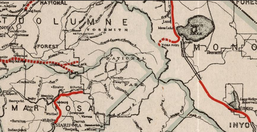
The 1917 California State Automobile Association highway map is the earliest edition that I can find which displays El Camino Sierra running from Coleville south to Saugus.


The first State Highway Map to display LRN 23 was published in 1918. The 1918 Division of Highways Map shows much of LRN 23 from Bridgeport south to Saugus as only a proposed road. The 1918 State Highway Map shows that LRN 23 was likely graded south of the Tioga Pass Road, graded near the Long Valley Reservoir, partially paved/graded between Bishop and Independence, and partially graded/paved between Palmdale south to Saugus.


El Camino Sierra can be seen as an Auto Trail marked with signs stating "ECS" on this 1920 Clauson Highway Map of California. The Midland Trail (formally known as the National Roosevelt Midland Trail) is marked as "NRM."


The 1920 Division of Highways Map shows El Camino Sierra paved between Palmdale south to Saugus. Further grading is shown extending south from Long Valley Reservoir in Mono County.

According to owensvalleyhistory LRN 23 was further funded during the 1919 Third State Highway Bond Act. By 1922 the route of El Camino Sierra/LRN 23 was paved between Lancaster north to Mojave. This is reflected on the 1922 Division of Highways Map along with numerous segments showing with paving under construction.

The 1924 Division of Highways Map shows El Camino Sierra/LRN 23 paved from Mojave south to Saugus. A further segment of pavement is shown complete to the north extending outward from Bishop.

On the 1924 Rand McNally Map of California only the Midland Trail is shown on El Camino Sierra. It is likely that Rand McNally was only interested in promoting Auto Trails that had national significance.


The 1930 Division of Highways Map shows various segments of pavement north of Mojave completed along El Camino Sierra/LRN 23.


In 1931 the southern end of El Camino Sierra/LRN 23 was extended to Newhall Pass when US 99/LRN 4 was moved to a new alignment. More can be found on the Legend of the Ridge Route blog..
Legend of the Ridge Route
The article on owensvalleyhistory.com states that all of El Camino Sierra/LRN 23 was paved by 1931. This doesn't appear to be the case as only the highway between Saugus north to Bishop is shown as paved on the 1932 Division of Highways Map. Much of the highway is shown as either paved or graded north to Coleville.


In 1933 El Camino Sierra was extended from Coleville to the Nevada State Line near Topaz Lake via the newly adopted LRN 95.
CAhighways.org on LRN 95
The entirety of El Camino Sierra on LRN 23 and LRN 95 was selected to be signed as part of the first CA 7 in 1934. CA 7 was announced in the August 1934 Department of Public Works guide below on Page 21 and Page 32.
August 1934 Department of Public Works Publication Announcing the Signed State Highways


The route of the first CA 7 in 1934 was as follows headed northbound from CA 3 in Torrence:
- LRN 164 to LRN 158 in West Los Angeles.
- LRN 158 in West Angeles to US 99/LRN 4 in San Fernando. LRN 158 originally connected Sepulveda Boulevard to San Fernando Boulevard (LRN 4) via Brand Boulevard.
- LRN 23 in San Fernando along the eastern flank of the Sierras to LRN 95 near Coleville.
- LRN 95 from Coleville to the Nevada State Line.
- CA 7 had a route gap through Nevada and resumed north of Reno on LRN 29. CA 7 followed LRN 29 to CA 36 near Susanville.
- LRN 73 from CA 36 north to the Oregon State Line.
Interestingly by the time CA 7 was announced the extension of US 395 southward into California had already been approved in June 1934 by the AASHTO. US 395 would assume CA 7 from the Oregon State Line and much of El Camino Sierra southward to Bradys possibly as early as October 1934 according to CAhighways.org.
CAhighways.org on US 395
In 1935 the California Division of Highways published county level maps of highway maintenance in California. The maps below show the early alignments of El Camino Sierra along US 395 and CA 7.
Mono County


Inyo County


Kern County


Los Angeles County
The 1935 Gousha Highway Map of California shows US 395 and CA 7 on El Camino Sierra.

By 1937 US 6 had been extended into California. US 6 multiplexed US 395 south of Bishop and assumed the route of CA 7 southward to Newhall Pass near Saugus. US 6 first appears on the 1938 State Highway Map. Prior to US 6 being extended into California the route of CA 168 briefly multiplexed first CA 7 and then US 395 in Bishop and followed LRN 96 to the Nevada State Line at Montgomery Pass. US 6 can be seen for the first time in California on the 1938 Division of Highways Map.


By 1940 the southern segment of US 6/LRN 23 was realigned out of Soledad Canyon onto Sierra Highway on a more direct route to Newhall Pass. This change can be see on the 1940 Division of Highways Map.

The southern segment of US 6/LRN 23 on El Camino Sierra gradually evolved into the modern CA 14/Antelope Valley Freeway, a full history can be found on this blog below.
CA 14/Antelope Valley Freeway
During the 1964 State Highway Renumbering US 6 was truncated back to US 395 in Bishop. What had been US 6 south of Bradys to Newhall Pass was renumbered as CA 14. CA 168 was extended south from Bishop on US 395 and east over Westgard Pass to the Nevada State Line. All hidden Legislative Route designations were dropped during the 1964 State Highway Renumbering. This was the genesis point of the modern designations of US 395/CA 168/CA 14 on El Camino Sierra, the changes can be observed the 1964 Division of Highways Map.


The 1967 Division of Highways Map was the first edition to clearly display four-lane expressway segments. The following segments of US 395/El Camino Sierra are shown above as expressway grade in 1967:
- The descent from Conway Summit.

- A small segment between Bishop and Lone Pine.

- A segment near Bartlett.

- A segment near Little Lake.

The 1969 Division of Highways Map shows new segments of expressway along US 395/El Camino Sierra near Sherwin Summit and near Independence.


The 1970 Division of Highways Map shows a new expressway segment of US 395/El Camino Sierra from Mammoth south to Tom's Place as complete.

The 1975 Caltrans Highwasy Map shows the US 395/El Camino Sierra expressway segment near Little Lake extended to the Kern County Line.

The 1977 Caltrans Highways Map shows US 395/El Camino Sierra with a two-lane expressway segment near Big Pine south to Independence and the Little Lake segment extended north past Coso Junction.

The 1981 Caltrans Highway map shows US 395/El Camino Sierra with new expressway segments south from Tom's Place towards Bishop and new segment south of Bishop. The Tom's Place segment is shown with a small conventional highway gap between the completed expressway.

The 1986 Caltrans Highway Map shows US 395/El Camino Sierra with a completed expressway gap near Tom's Place and four lanes entering Bishop.

The 1988 and 1990 State Highway maps don't show much change in US 395/El Camino Sierra. The maps jump to the 2005 Caltrans Map edition on Davidrumsey.com which shows US 395 as a conventional four lanes beginning south of the north junction with CA 158. Much of US 395 south of Bishop towards Big Pine is shown as a conventional four-lane highway. A new segment of four-lane US 395 is shown south of CA 136 to Bartlett along with four lanes south of Olancha to CA 14.


In 2010 a new finalized expressway segment from Lone Pine and Independence was completed. Recently in 2018 the California Transportation Commission approved a new expressway segment of US 395/El Camino Sierra bypassing Olancha and creating a new junction with CA 190. More on the current status of US 395 can be found on CAhighways.org.
CAhighways.org on US 395
Part 2; a drive on El Camino Sierra/US Route 395 from the Nevada State Line to CA 14
US 395/El Camino Sierra southbound enters Mono County California from the Nevada State Line at Topaz Lake (Post Mile MNO 120.481). US 395/El Camino Sierra south has the typical fare agriculture station which are common sights at many major State Line crossings. Interestingly Topaz Lake is bisected by the State Line and maintenance of the reservoir seems to be shared by California and Nevada. Topaz Lake is fed by the West Fork Walker River which merges with the East Fork Walker River downstream to form the main course of the Walker River which empties into Walker Lake of the Great Basin Desert

US 395 south to CA 89 was part of the LRN 95 portion of El Camino Sierra. At Post Mile MNO 116.972 US 395 intersects the south terminus of CA 89 as it descends from Monitor Pass.

CA 89 over Monitor Pass was the above mentioned segment of LRN 23 that took considerably time to actually build.


More on CA 89 over Monitor Pass can be found on the blog below.
CA 89 over Monitor Pass
US 395/El Camino Sierra begins to follow what was LRN 23 southward along the bank of the West Walker River. At approximately Post Mile MNO 111.459 enters the community of Coleville. Coleville dates back to the 1860s during the height of the mining boom in Mono County and is named after Cornelius Cole a Californian Congressman who served from 1867 to 1873. Coleville is located at approximately 5,141 feet above sea level.


US 395/El Camino south next enters the community of Walker at approximately Post Mile MNO 107.424. Walker lies at an elevation of 5,403 feet above sea level and much like the West Fork Walker River is named after Joseph R. Walker.


US 395/El Camino Sierra follows the West Walker River south towards Sonora Junction. At Post Mile MNO 100.217 the route US 395/El Camino south enters Toll House Canyon. Sonora Junction is located at Post Mile MNO 93.708 and serves as the junction between US 395 at the eastern terminus of CA 108. US 395/El Camino Sierra meets CA 108 roughly at the confluence of the West Fork Walker River and Little Walker River.


CA 108 westbound crosses the crest of the Sierra Nevada Mountains via 9,624 feet above sea level and emerges in Sonora. Travelers heading east from US 395 are advised of 26% uphill grades.

The first documented crossing of Sonora Pass was in October of 1841 which
apparently slightly north of the modern highway. The first attempted
wagon crossing of Sonora Pass was in 1852, the hazards of the roads of
the route were documented by Grizzly Adams later in 1854. A pack animal
route was laid out in 1862 on nearby St. Mary Pass which crossed the
Sierras at 10,040 feet above sea level. By 1863 the present Sonora Pass
alignment which CA 108 later adopted was surveyed and a toll road
opened in 1865.


More on CA 108 over Sonora Pass can be found below.
CA 108 over Sonora Pass
From Sonora Junction US 395/El Camino Sierra southbound takes an eastward swing via Hot Creek. At Post Mile MNO 87.895 US 395/El Camino Sierra crosses over the 7,519 foot high Devil's Gate Pass.

From Devil's Gate Pass US 395/El Camino Sierra south begins to swing southward along Swauger Creek towards Bridgeport. At approximately Post Mile 77.097 US 395/El Camino south enters the community of Bridgeport which is the Mono County Seat.

Bridgeport lies at an elevation of approximately 6,463 feet above sea level. Bridgeport was the second County Seat of Mono County after Aurora was found to be within the boundary of the State of Nevada. Of note the Mono County Courthouse in Bridgeport was constructed in 1880 and still serves it's original purpose. US 395/El Camino south crosses the East Fork Walker River in Bridgeport and meets CA 182 at Post Mile MNO 76.306. CA 182 continues northward to the Nevada State Line and becomes NV 338.


South of Bridgeport US 395/El Camino Sierra begins to follow the course of Virginia Creek. At Post Mile MNO 69.851 US 395/El Camino Sierra meets a junction with CA 270. CA 270 carries Bodie Road eastward towards the ghost town of Bodie.


CA 270 eastbound on Bodie Road continues for 10 miles where Caltrans maintenance ends the road becomes dirt. The dirt segment of Bodie Road continues onward to the ghost town of Bodie.


Bodie lies at an elevation of 8,379 feet above sea level and was established as a small mining camp in 1859 after the discovery of gold in the Bodie Hills sub-range of the Sierra Nevada Mountains. Large ore deposits were found in 1876 and 1878 which led to a population swell to at least 5,000 people in Bodie by 1879. The population decline in Bodie started in the 1880s and progressed through the early 20th century. By 1940 the Census showed only 40 residents left in the town of Bodie. The Bodie and Benton Railroad was dismantled in 1918 when the population of Bodie might have still exceeded just slightly over 100. Post Office Service stopped in Bodie in 1942 and there was only three people recorded living in the town by 1943. The remains of Bodie was turned into a State Park in 1962 when a little under 200 of the claimed original 2,000 buildings were left standings.


Bodie Road continues east of Bodie and follows Bodie Creek towards the Nevada State Line where the road becomes former Old NV 3C. Bodie Road continues another 3-4 miles east of the State Line to the Aurora ghost town. As stated above Aurora was once the Mono County seat until it was discovered to actually be located in the State of Nevada by surveyors.

More on CA 270 and Bodie can found on the blog below.
CA 270 to Bodie
South of CA 270 the route of US 395/El Camino Sierra encounters the ruins of Dog Town at Post Mile 69.529. Dog Town was the site of the first major Gold placer claim in the Eastern Sierra Range which was located in 1857. Dog Town was located at the confluence of Dog Town Creek and Virginia Creek, some ruins can still be seen today. Dog Town derived from miner slang for a community which consisted of mostly shacks and huts. Amusingly over a dozen communities in California were once known as Dog Town.


At Post Mile MNO 63.559 US 395/El Camino Sierra south ascends over the 8,143 foot Conway Summit. Conway Summit serves as the junction for Virginia Lakes Road which traverses west towards the campgrounds of the Virginia Lakes. From Conway Summit US 395/El Camino Sierra south begins to descend towards Mono Lake. At Post Mile MNO 62.524 there is an overlook of Mono Lake which views the rapidly descending US 395.

At the Mono Lake overlook there is a monument for the Monoville ghost town which was located a mile to the northeast. Monoville was founded on placer claims located in 1859 which led to a formation of town of 500-1,000 people. By 1862 Post Office service in Monoville shuttered and most of the miners had moved to the County Seat of Aurora.

US 395/El Camino Sierra curves through an expressway segment on a descent to CA 167 at Post Mile MNO 58.24. CA 167 was intended to be part of a new alignment of CA 120 and continues to the Nevada State Line on Pole Line Road. Of note CA 167 serves the access point for US 395/El Camino Sierra south into the borders of Inyo National Forest.

More on CA 167 can be found below.
CA 167
West of the junction of US 395 and CA 167 is Lundy Lake Road which ascends to a lake of the same name at 7,858 feet above sea level. Lundy Lake was the location of the ghost town known as Lundy. Lundy was a sawmill community that supplied nearby Bodie and had mining claims of it's own as well. Lundy appears to have to declined in the early 20th Century as Post Office was discontinued in 1914.


US 395/El Camino Sierra south is aligned west of Mono Lake and passes by Mono Lake Tufa State Reserve at Post Mile MNO 53.081. As US 395/El Camino Sierra enters Lee Vining there is access to the Mono Basin Scenic Area Visitor Center.


Mono Lake lies at an elevation of 6,383 feet above sea level and is a large saline lake which was formed about
760,000 years ago due to the endorheic basin it lies in. The current
maximum size of Mono Lake is 13x9.3 miles with an average depth of about
60 feet. Mono Lake was likely formed during the Long Valley Caldera
eruptions 760,000 years ago and may have been as deep as 900 feet during
the last Ice Age. Mono Lake has two large volcanic islands; Negit
Island and Paoha Island.


Lee Vining reportedly was the site of a mining claim as early as 1852. The modern community has origins in the 1920s when it was known as Lakeview. Apparently the Post Office refused to duplicate the name of Lakeview which was shared with a community in Riverside County which led to the current name of Lee Vining. Lee Vining is named after Leroy Vining which was founder of the 1852 mining claim. At Post Mile MNO 50.75 US 395/El Camino Sierra south picks up CA 120 eastbound.


CA 120 westbound ascends Lee Vining Canyon to the 9,943 foot high Tioga Pass. Tioga Pass is the highest highway mountain pass in California and continues westward as a National Park Service maintained roadway through Yosemite National Park.


Tioga Pass first obtained noteworthiness when a mining expedition
discovered silver at the Sheepherder Mine on Tioga Ridge during 1860.
The 1860 discovery of silver was not initially exploited and the finding
largely fell into obscurity. The Sheepherder silver claim was
rediscovered in 1875 (1874 according to the Division of Highways) by
William Brusky Jr. Brusky wasn't able to obtain a sizeable piece of ore
to bring to an assay until 1877. Claims at Tioga Ridge were formally
organized in 1878 which led to the establishment of the Tioga Mining
District. By 1880 the mining community of Dana at the site of the Great
Sierra Mine had become large enough to warrant Post Office Service. By
1881 the Great Sierra Consolidated Silver Company ("Great Sierra
Company") bought out all the mining claims on Tioga Ridge.
Tioga Pass can be seen as "McLanes Pass" on the 1868 California
Geological Survey Map of the Sierra Nevada Mountains near the vicinity
of Yosemite Valley.
1868 California Geoloical Survey Map

The mines at Tioga Ridge were initially accessible by way of trails through Lundy Canyon and Bloody Pass. The "Great Sierra Wagon Road" was proposed by the Great Sierra Company which had an estimated cost of $17,000 dollars in 1881 to build a road from the Big Oak Flat Road near Crane Flat east to the Tioga Peak mines. In 1882 the Great Sierra Company authorized a survey for a wagon road and railroad to the mines of Tioga Ridge which was completed by August during said year. In July of 1882 the California & Yosemite Short Line Railroad was incorporated with the intended goal of also building a rail line to the Tioga Mining District.
By September of 1883 the Great Sierra Wagon Road had been completed east from the Big Oak Flat Road to the Tioga Mining District. The Great Sierra Wagon Road never truly saw it's intended traffic load as the Tioga Mining District shuttered operations during mid-year 1884. The Great Sierra Wagon Road was intended to be a tolled facility but there is no records of any money actually being collected. As the years wore on the Great Sierra Wagon Road remained in periodic use but began to fall into disrepair due to a lack of maintenance.
In 1896 an appropriations bill to purchase the Great Sierra Wagon Road was proposed but never gained traction in the House of Representatives. In 1899 the Army was directed by Congress to survey the Great Sierra Wagon Road. The Army determined the Great Sierra Road while in a state of disrepair had been well engineered with an average gradient of 3%. A recommendation was made by the Yosemite National Park commissioners that the Great Sierra Wagon Road could be repaired for $2,000 dollars versus the cost of constructing a new highway for an estimated cost of approximately $61,000 dollars. Yosemite National Park thusly formally recommended that the Federal Government acquire the Great Sierra Wagon Road.
The Tioga Pass Road can be seen ending at the Tioga Mining District on the 1906 Norris Peters Map of Yosemite National Park. A trail over Mono Pass can be seen southeast of Tioga Pass.
1906 Norris Peters Map of Yosemite National Park


In 1899 what would become Legislative Route 40 ("LRN 40") was added to the State Highway System. The original definition of what became LRN 40 according to CAhighways.org called for:
"locating and constructing a free wagon road from the Mono Lake Basin to and connecting with a wagon road called the "Tioga Road" and near the "Tioga Mine"
The Department of Public Works first considered building the eastern extension of the Tioga Road to Mono Basin first via an established pack trail over Bloody Pass. By 1902 a new route via Lee Vining Canyon had been selected and construction began. The September 1950 California Highways & Public Works cites that by 1910 construction through Lee Vining Canyon to the Tioga Mine had yet been completed to State standards. A later Division of Highways guide (seen below) cites that LRN 40 east of Tioga Pass was completed during 1910.
September 1950 California Highways & Public Works


In 1911 the Federal Government brought a lawsuit against the franchise holders of the Great Sierra Wagon (referred to as the "Old Tioga Road"). The Federal suit argued that the Tioga Road had been long abandoned and sought to condemn the franchise rights so it could be incorporated as a Park Road. Ultimately the law suit found that the owners of the Tioga Road had maintained it enough that their claims to ownership were valid.
The completed Tioga Pass Road can be seen in detail on the 1914 USGS Map of Yosemite National Park.
1914 USGS Map of Yosemite National Park


The concept of the Federal Government acquiring the Tioga Road withing Yosemite National Park was not revisited until 1915. Stephen Mather, Assistant to the Secretary of the Interior sought to improve automotive access to Yosemite National Park. Mather learned that the purchase price of the Tioga Road within Yosemite National Park was $15,500 dollars. Mather along with several other private contributors purchased the Tioga Road with Yosemite. The Tioga Road was subsequently purchased by the Federal Government for $10 dollars on April 10th, 1915. The Tioga Pass Road was repaired and was opened to automotive traffic on July 28th, 1915. The first year the Tioga Pass Road was opened to traffic only 190 cars entered Yosemite National Park via Tioga Pass.
Much of the above early history of the Tioga Pass Road within Yosemite National Park was cited from Yosemite.ca article on Tioga Pass.
Yosemite.ca on the Tioga Pass Road
According to CAhighways.org in 1915 Legislative Chapter 306 and 396 changed the definition of LRN 40 to include all of the segments Tioga Pass Road and Big Oak Flat Road which were not in within the boundary of Yosemite National Park:
"that portion of the Great Sierra Wagon Road, better known as the Tioga Road, lying without the boundary of Yosemite National Park, providing that the portion within the park is taken over by the federal government." Chapter 396 added "that certain toll road in Tuolumne and Mariposa counties known as the Big Oak Flat and Yosemite Toll Road beginning at a point near the former location of Jack Bell Sawmill in Tuolumne Cty and extending thence in an E-ly direction through a portion of Mariposa Cty at Hamilton Station, thence again into Tuolumne Cty, past the Hearden Ranch, Crocker Station, Crane Flat, and Gin Flat to the boundary line of the original Yosemite Grant near Cascade Creek"
More on LRN 40 can be found on CAhighways.org:
CAhighways.org on Legislative Route 40
The original alignment of the Tioga Pass Road was considerably different than the modern highway. The original Tioga Pass Road diverged from the Big Oak Flat Road at the South Fork Tuolumne River via modern Evergreen Road. The Tioga Pass Road followed Evergreen Road to Aspen Valley Road. The Tioga Pass Road entered Yosemite National Park via what is now Aspen Valley Road to Aspen Valley. From Aspen Valley the original Tioga Pass Road followed the Old Tioga Road Trail to the White Wolf Lodge. From the White Wolf Lodge the Tioga Pass Road followed modern White Wolf Road back to the modern Tioga Pass Road. The original alignment of the completed Tioga Pass can be seen on the 1917 California State Automobile Association Map.
1917 California State Automobile Association Map

The below Gribblenation article features the original Big Oak Flat Road and Tioga Pass Road entrances to Yosemite National Park:
Old California State Route 140 and California State Route 120 entrances to Yosemite National Park
Early LRN 40 on the Tioga Pass Road and Big Oak Flat Road outside Yosemite National Park can be seen on the 1918 Division of Highways State Map of California.
In an August of 1934 Department of Public Works Guide the Sign State Routes were announced. CA 120 was announced as being signed east of Groveland through Yosemite National Park via the Tioga Pass Road. CA 140 was announced as entering Yosemite National Park via the El Portal Road and connecting to CA 120 through the park by way of the Big Oak Flat Road.

More on the Tioga Pass road can be foundin the article below.
The Tioga Pass Road
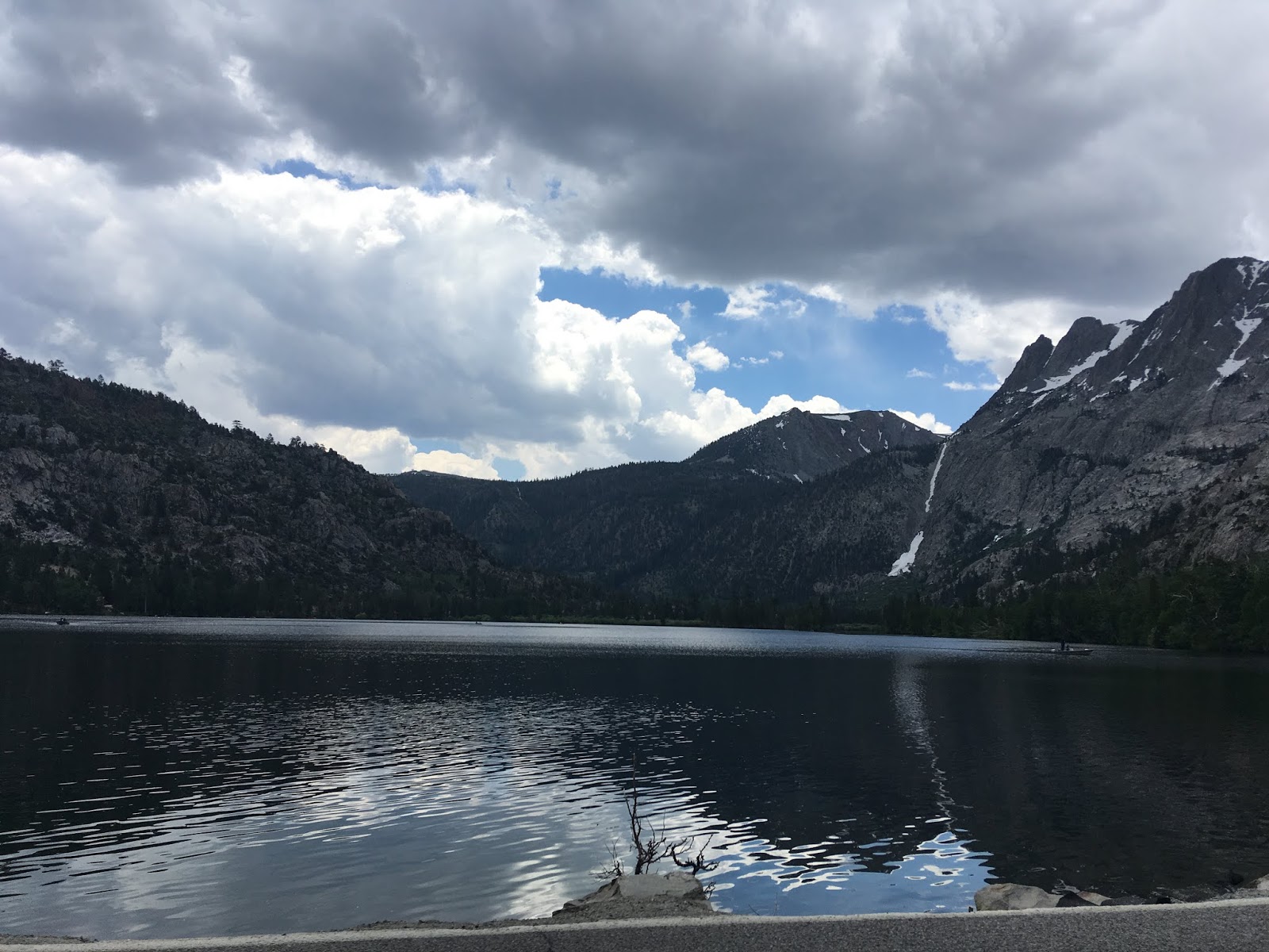
CA 120 east multiplexes US 395/El Camino Sierra south. At Post Mile MNO 46.378 CA 120 east/US 395 south meets the north junction of CA 158 the June Lake Loop.


CA 158 is a 16 mile loop route in the rural back country to/from US 395. Only the 3.5 southern most miles of CA 158 are kept open during the winter while the rest of the route closes for the winter. From the north terminus there are four lakes on CA 158; Grant, Silver, Gull, and June. All the lakes on CA 158 are sub-alpine and are fed from creeks emptying out of the eastern Sierras.


More on CA 158 can be found on the blog below.
CA 158; the June Lake Loop
From the north terminus of CA 158 a very old section of LRN 23 which is known as "Old State Highway Road"can be found approaching Rush Creek.


At Post Mile MNO 46.009 CA 120 east splits from US 395/El Camino Sierra south.


CA 120 crosses through a high plateau on the southern flank of Mono Lake which passes through the ghost towns of Mono Mills (which supplied Bodie with lumber) and Benton Hot Springs before reaching US 6.


More on CA 120 between US 395 and US 6 can be found on the blog below.
CA 120; US 6 west to US 395
At Post Mile MNO 40.343 US 395/El Camino Sierra south meets the south terminus of CA 158 at June Lake Junction. June Lake Junction lies at an elevation of 7,710 feet above sea level.


At Post Mile MNO 36.035 US 395/El Camino Sierra south crosses over the 8,047 foot high Deadman Summit. Deadman Summit is considered the northern rim of the Long Valley Volcanic Caldera. Deadman Summit gets it's name from a murder victim found in the location in 1868.


At Post Mile MNO 30.662 US 395/El Camino Sierra south has a junction with Mammoth Scenic Loop. Interestingly the "Mammoth Scenic Loop" was originally called the "Mammoth Escape Route" which was built after the 1980 Long Valley Earthquake. The Escape Route was built for an additional way out of Mammoth if there was some sort of disaster on the Long Valley Caldera. Apparently (total conjecture I've heard in passing) the name was changed because the business owners in Mammoth didn't like being reminded they live atop a massive volcano.


At approximately Post Mile MNO R26.144 US 395/El Camino Sierra south meets CA 203.


CA 203 is a short State Highway which traverses through Mammoth Lakes and ends at the Mammoth Mountain Ski Area. Modern Mammoth was a very much different place than the tourism crowd might see
on a trip to the ski resort. The area known as "Old Mammoth" was the
original site of "Mammoth City" which was built for the Mineral Hill
Mine which opened in 1878. Apparently the mine at Mineral Hill was
large enough that two smaller mining camps known as Mill City and Pine
City also were located near it. Mammoth City almost died out with far
less than 100 people by the early 1900s before rebounding to a
population sizable enough to warrant post office service by 1923. I'm
to understand that a gold boom in 1905 near the Devils Post Pile likely
played a
large role in reviving Mammoth.


The Mammoth Ski Area serves as access to Minaret Summit and Devil's Postpile National Monument. Minaret Summit lies at an elevation of 9,,265 feet and overlooks the Minarets which is a series of jagged peaks in the Ritter sub-range of the Sierras.

Across the Madera County Line lies Devil's Post Pile National Monument.

The Devil's Post Pile was originally in
the boundary of Yosemite National Park but some of the lands were made
public
during the gold boom. The Devil's Post Pile rock formations are volcanic in nature given them the appearance of cut logs. The rock formations were absorbed into Devils
Post Pile
National Monument in 1911 and really has been the subject of
infrastructure related conjecture of all kinds ranging from a reservoir
to a Trans-Sierra highway. More can be found on the failed plans for a Trans-Sierra Highway and CA 203 can be found below.
CA 203; the road that could have been a Trans-Sierra Highway
At Post Mile MNO 21.311 US 395/El Camino Sierra south has a junction with Convict Lake Road at Mammoth-Yosemite Airport.


Convict Lake lies at an elevation of 7,850 feet above sea level and is part of the Sherwin Sub-Range of the Sierra Nevada Mountains. Convict Lake get it's name from an 1871 gunfight which occurred on Convict Creek involving a posse chasing escaped prisoners out of Carson City.


At Post Mile MNO 20.367 US 395/El Camino Sierra south has a junction with Benton Crossing Road. Benton Crossing Road serves as a short cut to CA 120 from the Mammoth Area. At Post Mile MNO R18.038 US 395/El Camino Sierra has a junction with it's former alignment on Crowley Lake Drive.


At Post Mile MNO R14.623 US 395/El Camino Sierra south has an overlook of Crowley Lake. Crowley Lake was impounds the Owens River and began filling with water when the Long Valley Dam was completed in 1941. Crowley Lake is part of the Los Angeles Aqueduct system which is primarily intended to be used for water storage and flood control.

At Post Mile MNO R10.268 US 395/El Camino Sierra south has access to Tom's Place via Rock Creek Road (the highest paved road in California). Tom's Place lies at an elevation of 7,090 feet above sea level and is on a former alignment of US 395 on Lake Crowley Road. Tom's Place was a resort that was founded in 1919 and was known as Hans Lof's until Tom Yernby purchased it in 1922. US 395/El Camino Sierra south crosses the 7,000 foot modern Shermwin Summit and at Post Mile MNO R3.093 US 395/El Camino Sierra south has an overlook of Owen's Valley. Owens Valley extends 100 miles southward to the Mojave Desert via a gap split by the Sierra Nevada Mountains to the west White Mountains/Inyo Mountains to the east.


US 395/El Camino Sierra south passes close by the original 6,427 foot Sherwin Summit alignment on Old Sherwin Grade Road. Near Sherwin Summit the route of US 395/El Camino Sierra exits Inyo National Forest and follows the general course of Lower Rock Creek to the Inyo County Line at approximately Post Mile INY R129.455.


At Post Mile INY R126.14 US 395/El Camino Sierra south meets it's former alignment on Old Sherwin Grade Road by proxy via Pine Creek Road. Pine Creek Road follows Pine Creek westward past the ghost town of Scheelite towards Pine Creek Pass Recreation Area. Scheelite was a company town built around the tungsten mines of the Union Carbide Corporation. Scheelite was heavily damaged in the winter of 1969-1970 which led to the community being largely abandoned. Pine Creek Pass lies at an elevation of 11,132 feet and can easily be seen at the Owen's Valley Overlook mentioned above.


At Post Mile INY 118.29 US 395/El Camino Sierra south passes through the community of Brockmans Corner before entering the City of Bishop at Post Mile INY 117.3.25. Bishop is the only incorporated City in Inyo County and is located at an elevation of 4,150 feet above sea level on the floor of Owens Valley. Bishop is named after settler Samuel Anderson Bishop who established a homestead and ranch in Owens Valley in 1861. By 1862 a small settlement known as Bishop Creek was settled around the Bishop Ranch which grew into the modern day city.


At approximately Post Mile INY 116.402 US 395/El Camino Sierra south connects to US 6 eastbound via Wye Road. The actual west terminus of US 6 is located at approximately Post Mile INY 116.214 as US 395/El Camino Sierra south merges onto Main Street in downtown Bishop. This is where CA 168 originally continued eastbound towards the Nevada State Line from 1934 through 1937. From 1937 until the 1964 State Highway Renumbering US 6 west would multiplex US 395 south to the split where CA 14 presently begins.


US 6 is one of the longest US Routes at 3,205 miles between Bishop, CA east to Provincetown, MA. Historically US 6 was the longest US Route at 3,652 miles when it ended in Long Beach. US 6 is known as the Grand Army of the Republic Highway and is mostly known for traveling through some of the most rural corners of the Continental United States. Traffic leaving US 395 onto US 6 is greeted with a this large sign announcing the eastern terminus on US 6 the Grand Army of the Republic Highway.

Approximately four miles east of Bishop on US 6 is the former siding of the Carson & Colorado Railway known as Laws. The Carson & Colorado Railway was a narrow gauge line that ran from Mound House, NV near Carson City south to Keeler on the eastern shore of Owens Lake. When LRN 76 was first created it's path east of Bishop followed the tracks of the Carson & Colorado on unimproved roadways.
The Carson & Colorado Railway was created in 1880 with the intentions of reaching the Colorado River through the Mojave Desert. The Carson and Colorado Railway never reached further south than Keeler and the line was last used in 1960. Laws is where a small section of the Carson & Colorado is preserved at Laws Depot. Apparently the Carson and Colorado Railway was completed to Laws by 1883. Laws Depot is now preserved as the Laws Railroad Museum.


More on US 6 and Laws Depot can be found on the blog below.
The western end of US 6 and Laws Depot on the Carson & Colorado Railway
At approximately Post Mile 115.400 US 395/El Camino Sierra south on Main Street picks up CA 168 east at Line Street.


CA 168 west ascends into the Sierra Nevada Mountains where it has a gap in the highway at Camp Sabrina. CA 168 continues on the western side of the Sierra Nevada Mountains from Huntington Lake and ends at CA 41/CA 180 in Fresno. CA 168 was envisioned as a Trans-Sierra Highway which would have connected via Piute Pass. The Piute Pass Highway was conceived as a connecting route of the the Midland Trail before it was picked up as part of LRN 76. Part of the planned route of the Piute Pass Highway would have incorporated Kaiser Pass Road of the Big Creek Project. Kaiser Pass Road heading eastbound from the 9,184 foot high Kaiser Pass can be viewed below.

CA 168 over the Piute Pass Highway appears to have been blocked by the expansion of General Grant National Park into Kings Canyon National Park. More information about CA 168 and the unbuilt Piute Pass Highway can be found on the blog below.
Tale of CA 168 West and failed Piute Pass Highway
US 395 south/CA 168 east multiplex on El Camino Sierra south of Bishop. At approximately Post Mile INY 100.832 CA 168 east splits from US 395 south upon entering Big Pine.


Big Pine is a very early community of Owens Valley with Post Office Service opening in 1870. At Post Mile INY 100.321 US 395/El Camino Sierra south meets Crocker Avenue in Big Pine. Crocker Avenue becomes Glacier Lodge Road west of Big Pine and ascends to the Glacier Lodge. Glacier Lodge was established in 1917 and is located at approximately 8,000 feet above sea level in the Sierra Nevada Mountains along Big Pine Creek.


At approximately Post Mile INY 99.826 US 395/El Camino Sierra south briefly enters the Big Pine Reservation which is home to Mono and Timbisha tribal members.


As US 395/El Camino Sierra continues southward there are numerous older alignments to the west of the modern highway. At approximately Post Mile INY 77.296 US 395/El Camino Sierra south briefly enters the Fort Independence Indian Community of Paiute Indians.


At approximately Post Mile INY 76.053 US 395/El Camino Sierra south enters Independence which is the Inyo County seat. Independence is located at approximately 3,930 feet above sea level and was originally settled in 1861 as a trade post owned by Charles Putnam. Independence became the host locale of Camp Independence by 1862 which was eventually reorganized into Fort Independence by 1865. Independence became the Inyo County Seat in 1866 and managed to remain so despite Fort Independence closing in 1877.


Of note Inyo County was a successor County to the failed Coso County. Coso County as noted above was organized in 1864 and consisted of much of the land presently occupied by Inyo County. The Coso County Seat was located in Bend City which is now a ghost town located east of Independence over the Owens River.
At Post Mile INY 73.411 US 395/El Camino Sierra south meets Market Street in downtown Independence.

Market Street westward becomes Onion Valley Road which ascends to 9,163 feet above sea level approximately 13 miles west of Independence.

Onion Valley Road is located west of Independence of Inyo County and is
12.9 miles in length. According to pjammcycling.com Onion Valley Road
begins at an elevation of 3,946 feet above sea level in Independence and
terminates at 9,219 feet above sea level at Onion Valley. Pjammcycling
rates Onion Valley Road
with an average gradient of 7.8% and lists it as the 6th most difficult
cycling climb in the United States. Onion Valley Road also includes
ten switchbacks which largely follow the course of Independence Creek.
Anyway you look at it the route of Onion Valley Road is no joke and is
definitely a test of driving ability.
The route through Onion Valley to Kearsarge Pass was established as a path of travel due to the development of the Kearsarge Mine. The mining claims in Kearsarge Pass were discovered during the Fall of 1864 when a vein of silver and gold was located. These mining claims led to the establishment of the Kearsarge Mining District. Onion Valley Road was constructed as a haul road from nearby Independence to reach the mines of Kearsarge Pass. An avalanche during 1866 led to the relocation of much of population of Kearsarge Mine to Independence and Kearsarge Station on the Carson & Colorado Railroad. The Kearsarge Mine was named in honor of the Union Ship USS Kearsarge which sunk the CSS Alabama during the Civil War. The Kearsarge Mine operated on a significant scale until the early 1880s and was abandoned by 1888. Several attempts to redevelop the Kearsarge Mine during the 20th Century failed.
One of the more vexing mysteries of the early Sign State Route era which
has always intrigued me is the planned route of California State Route 180 ("CA 180") over Kearsarge
Pass. The original Sign State Route definition of CA 180 announced in
the August 1934 California Highways & Public Works shows that it was
intended to cross the Sierra Nevada Mountains to an eastern terminus at
Independence via Kings Canyon and Kearsarge Pass.


What would become CA 180 consisted partially of what was Legislative Route 41 ("LRN 41"). LRN 41 was loosely defined in
1905 according to CAhighways.org which authorized the following:
"locating,
surveying, and constructing a public highway from the General Grant
National Park in Fresno County, thence E-ly into Kings Canyon..."
During 1909 what would become LRN 41 was updated with the following definition:
"The
highway now completely located and surveyed, and partially completed
... from the General Grant National Park to the floor of the Kings River
Canyon is hereby made a state highway..."
The 1919 Third State
Highway Bond Act authorized funding for construction of the Kings River
Canyon State Road. This definition was updated in 1935 to specify three
segments of LRN 41:
- Legislative Route 5 near Tracy to [LRN 4] near Fresno
- Legislative Route 4 near Fresno to General Grant National Park
- General Grant National Park to Kings River Canyon
Notably the October 1931 California Highways & Public Works
discusses a reconnaissance trip of the South Fork Kings River Basin via
Kearsarge Pass, Bullfrog Lake, and Junction Meadow to survey snow
courses. The article elaborates further by stating a cooperative survey
between the Division of Highways and Forest Service was in the works to
survey a route for a new highway through Sequoia National Forest and Inyo National Forest.

Despite CA 180 clearly being intended in it's original definition to reach Independence the definition of LRN 41 was never extended east of Kings Canyon. This implies that any road from the Kings Canyon east over Kearsarge Pass to Independence would have been maintained by the Forest Service and Inyo County. Regardless several early Sign State Route era maps show CA 180 existing from near Kearsarge Pass east via Onion Valley Road to Independence (note; early Sign State Routes were signed by the Auto Clubs and not restricted to State Maintained Highways). CA 180 can be clearly seen on Onion Valley Road along with the planned connecting route over the Sierra Nevada Mountains to the Kings River Canyon on the 1935 Goshua Highway Map of California.

Onion Valley Road can be seen under local control on the 1935 Division of Highways Map of Inyo County.

The 1937 Goshua Highway Map of California also shows CA 180 on Onion Valley along with it's planned route west to the Kings River Canyon.

On March 4th 1940 General Grant National Park was expanded into what is now Kings Canyon National Park. The new boundary of Kings Canyon National Park annexed a great deal of Sequoia National Forest north from the boundary of Sequoia National Park towards the planned route of the Piute Pass Highway (planned CA 168). It seems that the National Park Service didn't have an interest in buildings a Trans-Sierra Highway via the Kings River Watershed or allowing the Piute Pass Highway as both routes more or less faded into obscurity. The newly expanded Kings Canyon National Park can be seen for the first time on the 1940 Division of Highways State Map.

The John Muir Wilderness was established in 1964 which enhanced protections over existing National Forest Lands. The John Muir Wilderness was enabled by the Wilderness Act of 1964 which largely sought to stop highway development in the Sierra Nevada Mountains.
A packing station in Onion Valley dating back to 1872 which
claims to be the oldest in the High Sierra. Notably the mining town of
Kearsarge was in the running for the first Inyo County Seat. Inyo
County was formed out of what Coso County on March 22nd 1866. The 1866
avalanche in the Kearsarge Mine occurred on March 1st which essentially
handed the County Seat to Independence. Reportedly there is still
evidence of foundations in Onion Valley and a pulley system which
climbed to Kearsarge Pass.


More information about Onion Valley Road and CA 180 in Kings Canyon can be found below.
Onion Valley Road; former California State Route 180 to Kearsarge Pass
CA 180; Fresno to Cedar Grove (Kings Canyon Highway)
US 395/El Camino Sierra south of Independence meets the entrance to Manzanar National Historic Site along Manzanar-Reward Road at Post Mile INY 67.987. Manzanar National Historic Site preserves the ruins of the World War II interment camp known as the Manzanar War Relocation Center which housed peak population of 11,070 Japanese-American Citizens.


Manzanar was founded in 1910 off of sub-divided ranching land. Manzanar as a community peaked out in the early 1920s and appears to never had more than more than thirty homes. After the Japanese Attack on Pearl Harbor on December 7th, 1941 there as a large push in California and the United States to exclude American Citizens of Japanese Descent into interment camps. Executive Order 9066 was authorized in February of 1942 and allowed the Army to build exclusion zones. Owens Valley Reception Center opened in March of 1942 which was quickly renamed to Manzanar War Relocation Center by June. Manzanar War Relocation Center was closed in November of 1945. Apparently citizens leaving the camps were only given $25 dollars for their involuntary confinement.
Much of the facility of Manzanar War Relocation Center is preserved in modern times.


At approximately Post Mile INY R61.527L US 395/El Camino Sierra south enters Lone Pine. Lone Pine was first inhabited by European Settlers when a cabin was constructed in the winter of 1861-1862. Post Office service in Lone Pine opened in 1870 and the community as been the head of many expeditions to nearby Mount Whitney. In 1872 most of Lone Pine was destroyed by an earthquake but the community was quickly rebuilt to continue the mining supply lines to nearby Cerro Gordo, Kearsarge, Keeler, Swansea and Darwin. Lone Pine was solidified in importance when it was connected to the Carson & Colorado Railway.


At Post Mile INY 57.67 US 395/El Camino Sierra south meets Whitney Portal Road. Whitney Portal Road is an approximately 13 mile roadway which ascends west from Lone Pine along Lone Pine Creek to Whitney Portal at 8,374 feet above sea level in the Sierra Nevada Mountains. Whitney Portal is the head of the Mount Whitney Trail which ascends to the peak of Mount Whitney the highest point in the Continental United States at 14,505 feet above sea level.

Of note; Whitney Port Road west of US 395 to Tuttle Creek Road was once part of CA 190. CA 190 was envisioned in 1934 as using part of the planned route of the Lone Pine-Porterville High Sierra Road. CA 190 would ascended west of Lone Pine to Horseshoe Meadows where it would have crossed the crest of the Sierra Nevada Mountains at Mulky Pass located approximately 11,300 feet above sea level. CA 190 would have crossed the Kern River Fault and met the western segment of CA 190 where it would have continued west to Porterville. The planned route of CA 190 was rerouted by 1960 and was again realigned over the approximately 8,200 foot high Hawiee Pass by 1966.

Horseshoe Meadows Road begins at an approximate elevation of 4,500 feet above sea level at Whitney Portal Road in the Alabama Hills and ends at an elevation of 10,072 feet above sea level in Horseshoe Meadows. Horseshoe Meadows Road is the second highest paved road in California only behind Rock Creek Road near Tom's Place. Pjammcycling rates Horseshoe Meadows Road with an average gradient of 6.2% and lists it as the 7th most difficult cycling climb in the United States. Horseshoe Meadows Road climbs the eastern flank of the Sierra Nevada Mountain via six well engineered switchbacks. Despite Horseshoe Meadows Road lacking a guardrail other nearby roads like Mineral King Road and Onion Valley Road are more difficult drives.
Horseshoe Meadows Road as noted above was part of what was known as the
Lone Pine-Porterville High Sierra Road. Much of the information below
is taken from already existing Gribblenation articles which pertain to
the history of the Lone Pine-Porterville High Sierra Road. The first
article pertains to the overall route of California State Route 190 ("CA
190") which originally included what is now Horseshoe Meadows Road.
The second article pertains to Sign County Route J37 ("J37") on Balch
Park Road which was also planned as part of the Lone Pine-Porterville
High Sierra Road.
California State Route 190
Sign County Route J37; the last Tulare Sign County Route and Lone Pine-Porterville High Sierra Road
Plans had been floated since 1923 to build a Trans-Sierra Highway via a route of Carroll Creek in Inyo County over the 11,300 foot high Mulky Pass. The road was to extend westward into Tulare County over the Kern Canyon Fault and emerge on what is now Signed County Route J37 on Balch Park Road. After crossing the North Fork Tule River the route would have split northwest on Yokohl Valley Drive to Visalia and on the route that became CA 190 southwest to Porterville. A map in the 1926 Los Angeles Times Article depicts a drawing of said Trans-Sierra Highway.


The below photo sourced from Tales from El Camino Sierra shows a dirt surface Horseshoe Meadows Road when it was a dirt surface.


More regarding Horseshoe Meadows Road and the Lone Pine-Porterville High Sierra Road can be found in the article below.
At approximately Post Mile INY 55.826 US 395/El Camino Sierra south meets CA 136. CA 136 was the original alignment of CA 190 and still remains somewhat co-signed likely to route traffic from Lone Pine towards Death Valley National Park.


The most beautiful (in my opinion) terminus in the State Highway system is located at where CA 136 meets US 395. Mount Whitney can be observed between the US 395/CA 136 shields and the Stop sign in the photo below.

CA 136 is 16 mile generally east/west highway which traverses the eastern shore of Owens Lake (whereas US 395 is aligned along the western shore). The ghost towns of Swansea, Keeler and Cerro Gordo are all accessible from CA 136 eastbound. Keeler in particular is notable given that it is still partially inhabited. Keeler was founded originally as "Hawley" in 1872 when the pier for the Cerro Gordo Mines at Swansea a couple miles north was lifted out of Owens Lake by the Lone Pine Earthquake. I'm not sure when the name of the town was changed to Keeler but the Carson & Colorado Railway did reach it by 1883. Keeler remained the southern terminus of the Carson and Colorado until it was shuttered in 1960. Apparently the tracks were removed later but the former rail depot has remained standing in Keeler as a derelict ever since.


The junction of CA 136/CA 190 is a great place to stop and get a
panoramic of the Owens Lake bed with the Sierras as a backdrop. Owens
Lake is fed by the Owens River and was thought to be as large as
200 square miles about 11,000 to 12,000 years ago. The water level of
Owens Lake was typically anywhere from 25 to 50 feet in depth and was
last full before the First Los Angeles Aqueduct project started to divert
water in 1913.

Horseshoe Meadows Road can be seen across Owens Lake from CA 136 and Keeler.

More on CA 136, Keeler and Owens lake can be found on the blog below.
CA 136
US 395/El Camino Sierra south of CA 136 passes by Diaz Lake which was created during the 1872 Lone Pine Earthquake. US 395 follows the western shore of Owens Lake passing through Bartlett and Cartago before meeting CA 190 in Olancha at approximately Post Mile INY 34.672.


South of Owens Lake US 395/El Camino Sierra enters the Mojave Desert. At approximately Post Mile INY 25.018 US 395/El Camino Sierra south passes through the community of Haiwee. Haiwee dates back to 1864 when it was stage stop, the original community was located in what is now the Haiwee Reservoir.


At Post Mile INY R20.879 US 395/El Camino Sierra south passes through the community of Dunmovin which has been noted for it's strange name.


At Post Mile INY R17.864 US 395/El Camino Sierra south passes through the former community of Coso Junction. At Post Mile INY R13.166 US 395/El Camino Sierra south passes through the former siding of Coso. At Post Mile INY R9.959 US 395/El Camino Sierra south passes through the former community of Little Lake.


At Post Mile INY R3.021 US 395/El Camino Sierra south meets Inyo County Route J41 at Nine Mile Canyon Road. Nine Mile Canyon Road ascends westward into the Sierra Nevada Mountains to Kennedy Meadows located at approximately 6,214 feet above sea level on the Kern Plateau. Nine Mile Canyon Road becomes Sherman Pass Road of Sequoia National Forest which crosses the crest of the Sierra Nevada Mountains to the Kern River Fault. Sherman Pass lies an elevation of approximately 9,200 feet above sea level and Sherman Pass Road is the newest Trans-Sierra Highway having been constructed in the 1970s.


More on Sherman Pass Road and Inyo County Route J41 can be found on the blog below.
Sherman Pass Road and Inyo County Route J41
At Post Mile INY R0.782 US 395/El Camino Sierra south passes through Pearsonville which carries the claim of the hub-cap capital of the world.


South of Pearsonville US 395/El Camino Sierra south enters Kern County at approximately Post Mile KER R36.822. At Post Mile KER R30.189 US 395/El Camino South passes through Bradys where it meets the north terminus of CA 14. El Camino Sierra south splits away onto CA 14 (former CA 7 and US 6) whereas US 395 continues southward towards I-15 in Hesperia.


Comments