Over the Fourth of July Holiday weekend I drove the entirety of California State Route 193.

CA 193 is a 36 mile rural highway which mostly traverses the lower portion of the Sierra Nevada Range. The route of CA 193 is oddly shaped and has a south terminus at CA 49 in Placerville and a hanging north terminus in the City of Lincoln. CA 193 is one of the oddest segments of State Highway given it includes ('kind of") silent multiplexes of CA 49 and Interstate 80 in addition to having a hanging end at a terminus point. Despite the oddities CA 193 is a highly scenic highway which runs through the Gold Rush Country and even incorporates a small segment of the North Lincoln Highway/early US Route 40 in Newcastle.
The present route of CA 193 was not one of the original Signed State Highways but was designated during the 1964 State Highway Renumbering. The Legislative Route Numbers that made up what became CA 193 are as follows:
- LRN 93 from from CA 49/LRN 65 in Placerville to CA 49/LRN 65 in Cool. According to CAhighways.org LRN 93 was adopted into the State Highway System in 1933.
- CA 49/LRN 65 from Cool to Auburn. LRN 65 between Auburn and Placerville was defined as a State Highway in 1921 and has been signed as CA 49 since 1934.
- LRN 17 between Auburn and Newcastle. LRN 17 was defined as a State Highway between Roseville and Nevada City during the 1909 First State Highway Bond Act. The segment of LRN 17 that CA 193 runs upon was once part of US 40 and presently I-80.
- LRN 91 between Newcastle and Lincoln. LRN 91 was adopted into the State Highway System in 1933.
The change from the LRNs described above to CA 193 can be seen by comparing the 1963 State Highway Map to the 1964 Edition. CA 193 on the whole is remarkable similar to how it was originally configured during the 1964 State Highway Renumbering.
1963 Division of Highways State Map

1964 Division of Highways State Map

Of note; the 1964 State Highway Map tends to imply that CA 193 multiplexed US 40 between Auburn and Lincoln. That said, the 1963 definition of CA 193 was in two segments according to CAhighways; CA 65 near Lincoln to I-80 and CA 49 in Cool to CA 49 near Placerville. US 40/I-80 are shown co-signed on the 1965 State Highway Map which in a sense would imply US 40/I-80/CA 193 multiplex between Auburn and Newcastle. To that end I'm not aware of any field signage where CA 193 was actually multiplexed in-field.
1965 Division of Highways State Map

It seems that CA 193 was assigned with the assumption that the two segments would be connected by the Auburn Dam. The following regarding CA 193 over the Auburn Dam was noted by Sparker of the AAroads Forum:
"CA 193, at least the section between Lincoln and I-80, has always been a bit of a conundrum; since '64, Caltrans has been a bit schizoid regarding multiplexes; there are no less than 10 signed multiplexes along US 101 -- but relatively few elsewhere in the state. I-80 has seen only three signed multiplexes (580, 113, and 89), at least until the CA 49 reroute in Auburn -- and 113 was "silent" until just a few years ago. But CA 193, despite both sections being in the same general area, is one of the oddest routes around -- and one of the few with a back-to-back (implied) multiplex with both CA 49 and I-80. The two routes, currently having different purposes, were given one number back in '64 -- with the understanding that a connector between the two would be a road running along the top of the never-built Auburn Dam, with CA 49, as illustrated elsewhere, rerouted over the Foresthill and proposed Middle Fork high bridges. There was no implied connection between the two; from the original commissioning to '64 the two sections were two separate LRN's (91 for Lincoln-Newcastle and 93 for the big "L" through Georgetown)."
The Auburn Dam was to be a thin arch concrete dam standing at 680 feet which would impound the North Fork American River. The Auburn Dam project was approved by Congress in 1965 and construction began in 1968. Construction of the Auburn Dam was halted in 1975 following an Earthquake centered in Oroville. The design of the Auburn Dam was deemed to be insufficient to stand up to a large earthquake which largely killed the project. Work on the Auburn Dam foundations resumed down river from the confluence of the Middle Fork and North Fork American Rivers in the late 1970s but the project never regained enough traction to be completed.
The 1967 State Highway Map is the first to show US 40 removed from California. This left on I-80/CA 193 multiplexing between Auburn and Newcastle. Of note; CA 49 is shown to have a planned bypass alignment of Placerville which was never constructed.
1967 Division of Highways State Map

Interestingly CAhighways.org notes that in 1972 the Legislative Definition of CA 193 was changed to have the south terminus end at US 50 in Placerville instead of CA 49. This decision seems to be based on the assumption that CA 49 would move onto a bypass of Placerville which can be still seen on the 1975 Caltrans State Highway Map. This decision was reversed by the State Legislature in 1984.

More recently as of 2009 both CA 49/CA 193 were moved to a new alignment in Auburn which reached I-80 via High Street and Elm Avenue. Previously CA 49/CA 193 followed High Street into downtown Auburn and reached I-80 via Lincoln Way in addition to Grass Valley Highway. More details about the reconfiguration of CA 49/CA 193 in Auburn can be found on the previous blog below.
CA 49 Golden Chain Highway Part 2; CA 16 to CA 89
According to CAhighways.org the original north terminus of CA 193 at McBean Park Drive/Lincoln Boulevard in Lincoln was relinquished 2011. Previously Lincoln Boulevard was originally signed as US 99E and CA 65 following the 1964 State Highway Renumbering. CA 193 in Lincoln was truncated due to the construction of the CA 65 Lincoln Bypass, more details can be found below on CAhighways.org.
CAhighways.org on CA 65
My approach to CA 193 northbound was from CA 49 north in Placerville of El Dorado County. CA 193 north of CA 49 is aligned on Georgetown Road and is signed as 15 miles form Georgetown.


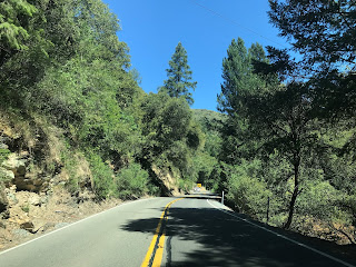
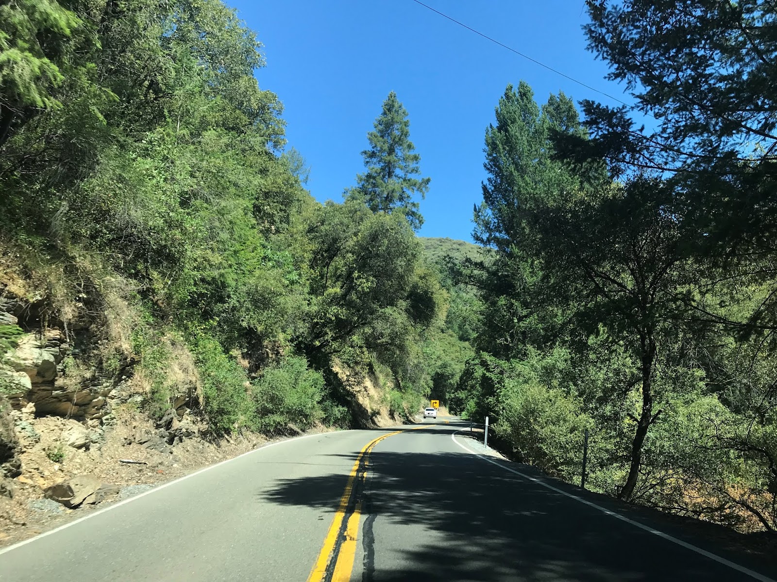
Almost immediately CA 193 north traffic is advised of the 11% grade descent into the South Fork American River Canyon.

CA 193 is both curvy and very steep as it winds it's way slowly to the South Fork American River.


The South Fork American River marks the boundary of the area known as the "Georgetown Divide." The Georgetown Divide stretches northward to Middle Fork American River.

At Post Mile ED R24.682 CA 193 north reaches the South Fork American River. Traffic is advised that Chili Bar Park is accessible via the north bank of the South Fork American River. Along the south bank of the South Fork American River is the location of the Chili Bar Slate Mine. Chili Bar was once a town site during the California Gold Rush and was founded by Chilean miners.


From the South Fork American River CA 193 begins a massive ascent up the Georgetown Divide. At Post Mile ED 23.949 CA 193 north has a significant junction with Rock Creek Road on a hairpin turn.


Rock Creek Road is significant as it accesses the wooden Mosquito Bridge located eastward upstream on the South Fork American River.

The Rock Creek Road hairpin is an excellent place to pull out and get a view of the South Fork American River. I also obtained my highway vista picture which I used for the cover of this blog at the Rock Creek Road hairpin.


CA 193 north continues to snake to the top of the Georgetown Divide before peaking out near Texas Canyon Road at approximately Post Mile ED 21.671.


CA 193 on the Georgetown Divide has a copious amount of roadways with animal themed names. The amusingly named Shoo Fly Road can be found at Post Mile ED 21.354.

CA 193 north passes through the community of Kelsey which dates back to mining claims founded by Benjamin Kelsey in 1848. At Post Mile ED 19.397 CA 193 north meets a significant junction with Garden Valley Road.


CA 193 north continues through the Georgetown Divide and enters the community of Georgetown at Post Mile ED 12.723.


Georgetown is signed as a historic place, the historic district of the community is located on Main Street. From Main Street CA 193 north is signed as 11 miles from Cool.


The downtown district of Georgetown was moved from Lower Main Street in 1852 to the present location following a major fire. Main Street in Georgetown is unique since it was an early example of civic planning in California and was designed to be 100 feet wide. Main Street in Georgetown features several historic structures such as an Odd Fellows Hall, the VFS Building and a Wells Fargo Stage Stop in the current Corner Kitchen Building.


There are several historic markers pertaining to the history of Georgetown at the community Fire Station. Georgetown was founded in 1849 by George Phipps off of mining claims located in Empire Canyon. Unlike most early mining claims in California the resources of Georgetown were found in the rocks surrounding the community and not placer mining. The section of Georgetown located on the outskirts of Lower Main Street came to be known as Growlersburg which was said to be named after the sounds of ore carried in the pants of the miners. Georgetown peaked circa 1854-1856 with a population of approximately 3,000 people. Mining remained active in the Georgetown area into the 20th Century ensuring the community survived.


Interestingly this mural actually shows CA 49 and CA 193 multiplexing between Auburn. I believe this is the only actual map of any kind that shows a multiplex of CA 49/CA 193.

CA 193 north of Georgetown passes through high lands of the Georgetown Divide and multiple traffic pull-outs. At Post Mile ED 6.971 there is signage directing traffic to a historic marker for the ghost town of Greenwood.


Greenwood was founded along Greenwood Creek in 1849 by John Greenwood. Greenwood apparently once boasted over twenty commercial buildings during it's prime. Main Street in Greenwood has a couple older structures still standing and an older bridge which offer evidence of a once larger community.


From Greenwood CA 193 north is signed as 6 miles from Cool.

CA 193 north north of Greenwood is signed as the Gene Chapie Memorial Highways. At Post Mile ED 0.00 CA 193 north meets CA 49 in Cool. Auburn is signed as being 6 miles away from Cool on CA 49/CA 193.


CA 193 north silently multiplexed onto CA 49 north of Cool.

North of Cool CA 49/CA 193 begins to descend into the American River Canyon to the confluence of the Middle Fork and North American Rivers. The Forest Hill Bridge can be seen descending on the 8% downhill grade into the American River Canyon.


CA 49/CA 193 crosses the North Fork American River and enters Placer County. CA 49/193 turns left on El Dorado Street and the Auburn State Recreation Area can be accessed on the right via Old Foresthill Road. The No Hands Bridge can be seen looking westward down the North Fork American River. The No Hands Bridge was completed in 1912 as part of the Mountain Quarries Railroad which operated until 1939. The Mountains Quarries Railroad connected from Auburn southward to the quarries near Cool.


The Auburn State Recreation Area starts at the confluence of the Middle Fork and North Fork American River. The Auburn State Recreation Area was set aside for the defunct Auburn Dam project which would have flooded the confluence of the Middle Fork and North Fork American Rivers.

Part of the Auburn Dam Project was Forest Hill Bridge over the North Fork American River which was intended to be a new alignment of CA 49. The Foresthill Bridge was constructed from 1971 to 1973 and has the highest bridge deck in California at 730 feet above the North Fork American River.

The below map was drafted showing the likely alignment of CA 49 over the Forest Hill Bridge. When I drafted the map I made it with the assumption that CA 193 wouldn't have crossed Auburn Dam.

CA 49/CA 193 north ascends the north bank of the North Fork American River to the City Limits of Auburn.


As noted above CA 49/CA 193 north traverses Auburn via High Street and Elm Avenue where both multiplex onto I-80 westbound.


Both CA 49/CA 193 north silently multiplex I-80 west. CA 49 north splits away from I-80 at Exit 119B towards Grass Valley.


CA 193 north multiplexes I-80 to Exit 116 onto Taylor Road near the outskirts of Newcastle. From Exit 116 the signage of CA 193 resumes on Taylor Road at Post Mile PLA 10.139.


Taylor Road in Newcastle was partially the alignment of the North Lincoln Highway and early US Route 40. Originally the North Lincoln Highway and early US 40 followed the route of CA 193 north onto Newcastle Highway and made a turn into downtown Newcastle via Old State Highway at Post Mile PLA 9.674.


The North Lincoln Highway and US 40 originally entered Newcastle via the 1910 Newcastle Subway. The Newcastle Subway was possibly the first highway Subway built by the Department of Public Works in California as part of LRN 17. The 1910 Newcastle Subway is a single lane with only a 12 foot high clearance. The Lincoln Highway shield on the 1910 Newcastle Subway was painted just this past month.


The alignment of the Lincoln Highway and US 40 in Newcastle circled the community via Old State Highway. On Main Street there is still access to downtown Newcastle and the shipping yards that were once serviced by the Central Pacific Railroad. Newcastle was founded as a siding of the First Trans-Continental Railroad in 1864 and was the head for the stage routes heading over Donner Pass via the Dutch Flat & Donner Lake Wagon Road. The Dutch Flat & Donner Lake Wagon Road was utilized to not only cross the Sierra Nevada Mountains but also to haul construction materials for the First Trans-Continental Railroad. The Dutch Flat & Donner Lake Wagon Road would later become part of the North Lincoln Highway and LRN 37 during the 1909 First State Highway Bond Act.


The North Lincoln Highway and early US 40 continued through Newcastle on Old State Highway where both made a western turn onto Taylor Road. US 40 in 1932 was rerouted on a bypass of Newcastle via the Newcastle Tunnel.


From Newcastle CA 193 north is signed with 5 miles of curves on Newcastle Highway.

CA 193 north continues through the Sierra Foothills on Newcastle Highway before emerging onto relatively flat terrain at Post Mile PLA 3.000.


At approximately Post Mile PLA 1.347 CA 193 north terminates at Oak Tree Lane which is the boundary for the City of Lincoln.


CA 193 is a 36 mile rural highway which mostly traverses the lower portion of the Sierra Nevada Range. The route of CA 193 is oddly shaped and has a south terminus at CA 49 in Placerville and a hanging north terminus in the City of Lincoln. CA 193 is one of the oddest segments of State Highway given it includes ('kind of") silent multiplexes of CA 49 and Interstate 80 in addition to having a hanging end at a terminus point. Despite the oddities CA 193 is a highly scenic highway which runs through the Gold Rush Country and even incorporates a small segment of the North Lincoln Highway/early US Route 40 in Newcastle.
The present route of CA 193 was not one of the original Signed State Highways but was designated during the 1964 State Highway Renumbering. The Legislative Route Numbers that made up what became CA 193 are as follows:
- LRN 93 from from CA 49/LRN 65 in Placerville to CA 49/LRN 65 in Cool. According to CAhighways.org LRN 93 was adopted into the State Highway System in 1933.
- CA 49/LRN 65 from Cool to Auburn. LRN 65 between Auburn and Placerville was defined as a State Highway in 1921 and has been signed as CA 49 since 1934.
- LRN 17 between Auburn and Newcastle. LRN 17 was defined as a State Highway between Roseville and Nevada City during the 1909 First State Highway Bond Act. The segment of LRN 17 that CA 193 runs upon was once part of US 40 and presently I-80.
- LRN 91 between Newcastle and Lincoln. LRN 91 was adopted into the State Highway System in 1933.
The change from the LRNs described above to CA 193 can be seen by comparing the 1963 State Highway Map to the 1964 Edition. CA 193 on the whole is remarkable similar to how it was originally configured during the 1964 State Highway Renumbering.
1963 Division of Highways State Map

1964 Division of Highways State Map

Of note; the 1964 State Highway Map tends to imply that CA 193 multiplexed US 40 between Auburn and Lincoln. That said, the 1963 definition of CA 193 was in two segments according to CAhighways; CA 65 near Lincoln to I-80 and CA 49 in Cool to CA 49 near Placerville. US 40/I-80 are shown co-signed on the 1965 State Highway Map which in a sense would imply US 40/I-80/CA 193 multiplex between Auburn and Newcastle. To that end I'm not aware of any field signage where CA 193 was actually multiplexed in-field.
1965 Division of Highways State Map

It seems that CA 193 was assigned with the assumption that the two segments would be connected by the Auburn Dam. The following regarding CA 193 over the Auburn Dam was noted by Sparker of the AAroads Forum:
"CA 193, at least the section between Lincoln and I-80, has always been a bit of a conundrum; since '64, Caltrans has been a bit schizoid regarding multiplexes; there are no less than 10 signed multiplexes along US 101 -- but relatively few elsewhere in the state. I-80 has seen only three signed multiplexes (580, 113, and 89), at least until the CA 49 reroute in Auburn -- and 113 was "silent" until just a few years ago. But CA 193, despite both sections being in the same general area, is one of the oddest routes around -- and one of the few with a back-to-back (implied) multiplex with both CA 49 and I-80. The two routes, currently having different purposes, were given one number back in '64 -- with the understanding that a connector between the two would be a road running along the top of the never-built Auburn Dam, with CA 49, as illustrated elsewhere, rerouted over the Foresthill and proposed Middle Fork high bridges. There was no implied connection between the two; from the original commissioning to '64 the two sections were two separate LRN's (91 for Lincoln-Newcastle and 93 for the big "L" through Georgetown)."
The Auburn Dam was to be a thin arch concrete dam standing at 680 feet which would impound the North Fork American River. The Auburn Dam project was approved by Congress in 1965 and construction began in 1968. Construction of the Auburn Dam was halted in 1975 following an Earthquake centered in Oroville. The design of the Auburn Dam was deemed to be insufficient to stand up to a large earthquake which largely killed the project. Work on the Auburn Dam foundations resumed down river from the confluence of the Middle Fork and North Fork American Rivers in the late 1970s but the project never regained enough traction to be completed.
The 1967 State Highway Map is the first to show US 40 removed from California. This left on I-80/CA 193 multiplexing between Auburn and Newcastle. Of note; CA 49 is shown to have a planned bypass alignment of Placerville which was never constructed.
1967 Division of Highways State Map

Interestingly CAhighways.org notes that in 1972 the Legislative Definition of CA 193 was changed to have the south terminus end at US 50 in Placerville instead of CA 49. This decision seems to be based on the assumption that CA 49 would move onto a bypass of Placerville which can be still seen on the 1975 Caltrans State Highway Map. This decision was reversed by the State Legislature in 1984.

More recently as of 2009 both CA 49/CA 193 were moved to a new alignment in Auburn which reached I-80 via High Street and Elm Avenue. Previously CA 49/CA 193 followed High Street into downtown Auburn and reached I-80 via Lincoln Way in addition to Grass Valley Highway. More details about the reconfiguration of CA 49/CA 193 in Auburn can be found on the previous blog below.
CA 49 Golden Chain Highway Part 2; CA 16 to CA 89
According to CAhighways.org the original north terminus of CA 193 at McBean Park Drive/Lincoln Boulevard in Lincoln was relinquished 2011. Previously Lincoln Boulevard was originally signed as US 99E and CA 65 following the 1964 State Highway Renumbering. CA 193 in Lincoln was truncated due to the construction of the CA 65 Lincoln Bypass, more details can be found below on CAhighways.org.
CAhighways.org on CA 65
My approach to CA 193 northbound was from CA 49 north in Placerville of El Dorado County. CA 193 north of CA 49 is aligned on Georgetown Road and is signed as 15 miles form Georgetown.


Almost immediately CA 193 north traffic is advised of the 11% grade descent into the South Fork American River Canyon.

CA 193 is both curvy and very steep as it winds it's way slowly to the South Fork American River.


The South Fork American River marks the boundary of the area known as the "Georgetown Divide." The Georgetown Divide stretches northward to Middle Fork American River.

At Post Mile ED R24.682 CA 193 north reaches the South Fork American River. Traffic is advised that Chili Bar Park is accessible via the north bank of the South Fork American River. Along the south bank of the South Fork American River is the location of the Chili Bar Slate Mine. Chili Bar was once a town site during the California Gold Rush and was founded by Chilean miners.


From the South Fork American River CA 193 begins a massive ascent up the Georgetown Divide. At Post Mile ED 23.949 CA 193 north has a significant junction with Rock Creek Road on a hairpin turn.


Rock Creek Road is significant as it accesses the wooden Mosquito Bridge located eastward upstream on the South Fork American River.

The Rock Creek Road hairpin is an excellent place to pull out and get a view of the South Fork American River. I also obtained my highway vista picture which I used for the cover of this blog at the Rock Creek Road hairpin.


CA 193 north continues to snake to the top of the Georgetown Divide before peaking out near Texas Canyon Road at approximately Post Mile ED 21.671.


CA 193 on the Georgetown Divide has a copious amount of roadways with animal themed names. The amusingly named Shoo Fly Road can be found at Post Mile ED 21.354.

CA 193 north passes through the community of Kelsey which dates back to mining claims founded by Benjamin Kelsey in 1848. At Post Mile ED 19.397 CA 193 north meets a significant junction with Garden Valley Road.


CA 193 north continues through the Georgetown Divide and enters the community of Georgetown at Post Mile ED 12.723.


Georgetown is signed as a historic place, the historic district of the community is located on Main Street. From Main Street CA 193 north is signed as 11 miles from Cool.


The downtown district of Georgetown was moved from Lower Main Street in 1852 to the present location following a major fire. Main Street in Georgetown is unique since it was an early example of civic planning in California and was designed to be 100 feet wide. Main Street in Georgetown features several historic structures such as an Odd Fellows Hall, the VFS Building and a Wells Fargo Stage Stop in the current Corner Kitchen Building.


There are several historic markers pertaining to the history of Georgetown at the community Fire Station. Georgetown was founded in 1849 by George Phipps off of mining claims located in Empire Canyon. Unlike most early mining claims in California the resources of Georgetown were found in the rocks surrounding the community and not placer mining. The section of Georgetown located on the outskirts of Lower Main Street came to be known as Growlersburg which was said to be named after the sounds of ore carried in the pants of the miners. Georgetown peaked circa 1854-1856 with a population of approximately 3,000 people. Mining remained active in the Georgetown area into the 20th Century ensuring the community survived.


Interestingly this mural actually shows CA 49 and CA 193 multiplexing between Auburn. I believe this is the only actual map of any kind that shows a multiplex of CA 49/CA 193.

CA 193 north of Georgetown passes through high lands of the Georgetown Divide and multiple traffic pull-outs. At Post Mile ED 6.971 there is signage directing traffic to a historic marker for the ghost town of Greenwood.


Greenwood was founded along Greenwood Creek in 1849 by John Greenwood. Greenwood apparently once boasted over twenty commercial buildings during it's prime. Main Street in Greenwood has a couple older structures still standing and an older bridge which offer evidence of a once larger community.


From Greenwood CA 193 north is signed as 6 miles from Cool.

CA 193 north north of Greenwood is signed as the Gene Chapie Memorial Highways. At Post Mile ED 0.00 CA 193 north meets CA 49 in Cool. Auburn is signed as being 6 miles away from Cool on CA 49/CA 193.


CA 193 north silently multiplexed onto CA 49 north of Cool.

North of Cool CA 49/CA 193 begins to descend into the American River Canyon to the confluence of the Middle Fork and North American Rivers. The Forest Hill Bridge can be seen descending on the 8% downhill grade into the American River Canyon.


CA 49/CA 193 crosses the North Fork American River and enters Placer County. CA 49/193 turns left on El Dorado Street and the Auburn State Recreation Area can be accessed on the right via Old Foresthill Road. The No Hands Bridge can be seen looking westward down the North Fork American River. The No Hands Bridge was completed in 1912 as part of the Mountain Quarries Railroad which operated until 1939. The Mountains Quarries Railroad connected from Auburn southward to the quarries near Cool.


The Auburn State Recreation Area starts at the confluence of the Middle Fork and North Fork American River. The Auburn State Recreation Area was set aside for the defunct Auburn Dam project which would have flooded the confluence of the Middle Fork and North Fork American Rivers.

Part of the Auburn Dam Project was Forest Hill Bridge over the North Fork American River which was intended to be a new alignment of CA 49. The Foresthill Bridge was constructed from 1971 to 1973 and has the highest bridge deck in California at 730 feet above the North Fork American River.

The below map was drafted showing the likely alignment of CA 49 over the Forest Hill Bridge. When I drafted the map I made it with the assumption that CA 193 wouldn't have crossed Auburn Dam.

CA 49/CA 193 north ascends the north bank of the North Fork American River to the City Limits of Auburn.


As noted above CA 49/CA 193 north traverses Auburn via High Street and Elm Avenue where both multiplex onto I-80 westbound.


Both CA 49/CA 193 north silently multiplex I-80 west. CA 49 north splits away from I-80 at Exit 119B towards Grass Valley.


CA 193 north multiplexes I-80 to Exit 116 onto Taylor Road near the outskirts of Newcastle. From Exit 116 the signage of CA 193 resumes on Taylor Road at Post Mile PLA 10.139.


Taylor Road in Newcastle was partially the alignment of the North Lincoln Highway and early US Route 40. Originally the North Lincoln Highway and early US 40 followed the route of CA 193 north onto Newcastle Highway and made a turn into downtown Newcastle via Old State Highway at Post Mile PLA 9.674.


The North Lincoln Highway and US 40 originally entered Newcastle via the 1910 Newcastle Subway. The Newcastle Subway was possibly the first highway Subway built by the Department of Public Works in California as part of LRN 17. The 1910 Newcastle Subway is a single lane with only a 12 foot high clearance. The Lincoln Highway shield on the 1910 Newcastle Subway was painted just this past month.


The alignment of the Lincoln Highway and US 40 in Newcastle circled the community via Old State Highway. On Main Street there is still access to downtown Newcastle and the shipping yards that were once serviced by the Central Pacific Railroad. Newcastle was founded as a siding of the First Trans-Continental Railroad in 1864 and was the head for the stage routes heading over Donner Pass via the Dutch Flat & Donner Lake Wagon Road. The Dutch Flat & Donner Lake Wagon Road was utilized to not only cross the Sierra Nevada Mountains but also to haul construction materials for the First Trans-Continental Railroad. The Dutch Flat & Donner Lake Wagon Road would later become part of the North Lincoln Highway and LRN 37 during the 1909 First State Highway Bond Act.


The North Lincoln Highway and early US 40 continued through Newcastle on Old State Highway where both made a western turn onto Taylor Road. US 40 in 1932 was rerouted on a bypass of Newcastle via the Newcastle Tunnel.


From Newcastle CA 193 north is signed with 5 miles of curves on Newcastle Highway.

CA 193 north continues through the Sierra Foothills on Newcastle Highway before emerging onto relatively flat terrain at Post Mile PLA 3.000.


At approximately Post Mile PLA 1.347 CA 193 north terminates at Oak Tree Lane which is the boundary for the City of Lincoln.


Comments