Horseshoe Meadows Road; former California State Route 190 and the legacy of the Lone Pine-Porterville HIgh Sierra Road

This summer I had an opportunity to drive one of the lesser known great roads of California; Horseshoe Meadows Road from Whitney Portal Road westward into Horseshoe Meadows of the Eastern Sierra Nevada Mountains. Aside from being massive climb into the Eastern Sierra Nevada Mountains the path of Horseshoe Meadows Road was once part of California State Route 190 and was intended to be part of a Trans-Sierra Highway known as the Lone Pine-Porterville High Sierra Road.
Horseshoe Meadows Road is located west of Lone Pine of Inyo County and is
19.7 miles in length. Horseshoe Meadows Road begins at an approximate elevation of 4,500 feet above sea level at Whitney Portal Road in the Alabama Hills and ends at an elevation of 10,072 feet above sea level in Horseshoe Meadows. Horseshoe Meadows Road is the second highest paved road in California only behind Rock Creek Road near Tom's Place. Pjammcycling
rates Horseshoe Meadows Road with an average gradient of 6.2% and lists it as the 7th most difficult
cycling climb in the United States. Horseshoe Meadows Road climbs the eastern flank of the Sierra Nevada Mountain via six well engineered switchbacks. Despite Horseshoe Meadows Road lacking a guardrail other nearby roads like Mineral King Road and Onion Valley Road are more difficult drives.

My choice in vehicle for the drive on Horseshoe Meadows Road was my 2016 Dodge Challenger Scat Pack. My daily driver is a Subaru Impreza which often might seem ideal for such a road in most circumstances. That said, earlier this year I took my Impreza up Mineral King Road in Sequoia National Park. The uphill climb on Mineral King Road wasn't so much of an issue but holding a low gear with the Impreza's CVT was not an easy endeavor heading back downhill. Having a large 392 cubic engine, an eight speed transmission and four wheel vented disc brakes seemed like a must have on Horseshoe Meadows Road (which proved a good choice earlier in the day on Onion Valley Road). Besides, a cool road (especially when paved the whole way) in my opinion demands a cool car.

Part 1; the history of the Lone Pine-Porterville High Sierra Road and early California State Route 190
Horseshoe Meadows Road as noted above was part of what was known as the Lone Pine-Porterville High Sierra Road. Much of the information below is taken from already existing Gribblenation articles which pertain to the history of the Lone Pine-Porterville High Sierra Road. The first article pertains to the overall route of California State Route 190 ("CA 190") which originally included what is now Horseshoe Meadows Road. The second article pertains to Sign County Route J37 ("J37") on Balch Park Road which was also planned as part of the Lone Pine-Porterville High Sierra Road.
California State Route 190
Sign County Route J37; the last Tulare Sign County Route and Lone Pine-Porterville High Sierra Road


The below photo sourced from Tales from El Camino Sierra shows a dirt surface Horseshoe Meadows Road when it was a dirt surface.


Horseshoe Meadows Road is a very obvious feature in the Eastern Sierra Nevada Mountains given it's cut is easy to observe from a distance. I took this photo Horseshoe Meadows Road in 2017 from the ghost town of Keeler on the eastern shore of Owens Lake.

My approach to Horseshoe Meadows Road was from US Route 395 south in Lone Pine. To get to Horseshoe Meadows Road I took a westward turn onto Whitney Portal Road.

Whitney Portal Road westbound follows the old alignment of CA 190 to Tuttle Creek Road. As noted above Tuttle Creek Road is where CA 190 would have turned south towards Carroll Creek.


From Tuttle Creek Road the path of Whitney Portal Road ascends westward through the Alabama Hills to the modern terminus of Horseshoe Meadows Road. Upon reaching Horseshoe Meadows Road I turned left to head south.


Horseshoe Meadows Road travels immediately south from Whitney Portal Road. Horseshoe Meadows Road has a major intersection with Lubken Canyon Road and merges into the former alignment of CA 190 at the abandoned segment of Tuttle Creek Road.


Horseshoe Meadows Road continues south and crosses over Carroll Creek at DeLaCour Ranch. Traffic is advised of 10 miles of rockfall zones ahead.


From Carroll Creek the Horseshoe Meadows Road ascends into the Sierra Nevada Mountains, enters Inyo National Forest, and hits the first switchback.


Horseshoe Meadows Road swings north towards switchback number two.


Horseshoe Meadows Road takes a southward swing towards switchback number three.


Horseshoe Meadows Road makes a northwest jog towards switchback number four.


Horseshoe Meadows Road makes a southern turn and then a western jog towards switchback number five.


Horseshoe Meadows Road makes a quick turn east towards switchback number six.


Horseshoe Meadows Road turns west and crests at about 9,500 feet before taking a dip in elevation towards Cottonwood Creek.


Horseshoe Meadows Road makes one more western climb at terminates at the campgrounds of Horseshoe Meadows at 10,072 feet above sea level.


Horseshoe Meadows lies at the confluence of numerous streams. From Horseshoe Meadows Mulky Pass can be seen to the south in the Golden Trout Wilderness. The Kern River Fault is only a couple miles westward which illustrates how far the Lone Pine-Porterville High Sierra Road really got to towards being completed.


Part 3; a drive down Horseshoe Meadows Road
From Horseshoe Meadows traffic on Horseshoe Meadows Road is advised that Lone Pine is 20 miles away (which is actually closer to 24 miles).

Horseshoe Meadows makes a brief descent before climbing back up to a vista of Owens Lake.


Horseshoe Meadows Road approaching switchback number six passes by Walt's Point which I'm to understand is used for a hang glider launch.


Horseshoe Meadows Road approaching switchback number six.


Horseshoe Meadows Road approaching switchback number five.


Horseshoe Meadows Road approaching switchback number four.


Horseshoe Meadows Road approaching switchback number three.


Horseshoe Meadows Road approaching switchback number two.


Horseshoe Meadows Road approaching switchback number one.


Horseshoe Meadows Road leaving Inyo National Forest and descending to Carroll Creek.


Horseshoe Meadows Road descending to Whitney Portal Road in the Alabama Hills.


In the previous Onion Valley Road article I made note of the operating conditions of the Challenger. Really I didn't find much notable to really say about the condition of my engine coolant heading uphill or brakes heading downhill on Horseshoe Meadows Road. The grade being only an average of 6.2% on Horseshoe Meadows Road versus an average of 7.8% on Onion Valley Road definitely was something that I can tell made the drive on the former much easier than the latter. Before returning to US Route 395 in Lone Pine I did take note of this oddity on Whitney Portal Road in the Alabama Hills.


My choice in vehicle for the drive on Horseshoe Meadows Road was my 2016 Dodge Challenger Scat Pack. My daily driver is a Subaru Impreza which often might seem ideal for such a road in most circumstances. That said, earlier this year I took my Impreza up Mineral King Road in Sequoia National Park. The uphill climb on Mineral King Road wasn't so much of an issue but holding a low gear with the Impreza's CVT was not an easy endeavor heading back downhill. Having a large 392 cubic engine, an eight speed transmission and four wheel vented disc brakes seemed like a must have on Horseshoe Meadows Road (which proved a good choice earlier in the day on Onion Valley Road). Besides, a cool road (especially when paved the whole way) in my opinion demands a cool car.

Part 1; the history of the Lone Pine-Porterville High Sierra Road and early California State Route 190
Horseshoe Meadows Road as noted above was part of what was known as the Lone Pine-Porterville High Sierra Road. Much of the information below is taken from already existing Gribblenation articles which pertain to the history of the Lone Pine-Porterville High Sierra Road. The first article pertains to the overall route of California State Route 190 ("CA 190") which originally included what is now Horseshoe Meadows Road. The second article pertains to Sign County Route J37 ("J37") on Balch Park Road which was also planned as part of the Lone Pine-Porterville High Sierra Road.
California State Route 190
Sign County Route J37; the last Tulare Sign County Route and Lone Pine-Porterville High Sierra Road
Plans had been floated since 1923 to build a Trans-Sierra
Highway via a route of Carroll Creek in Inyo County over the 11,300 foot
high Mulky Pass. The road was to extend westward into Tulare County
over the Kern Canyon Fault and emerge on what is now Signed County Route
J37 on Balch Park Road. After crossing the North Fork Tule River the
route would have split northwest on Yokohl Valley Drive to Visalia and
on the route that became CA 190 southwest to Porterville. A map in the
1926 Los Angeles Times Article depicts a drawing of said Trans-Sierra
Highway.

$1,000,000 dollars was set aside to build the Lone Pine-Porterville High Sierra Road. What became Horseshoe Meadows Road from Carroll Creek was on
land owned by the City of Los Angeles. The City of Los Angeles was slated to contribute $170,000 dollars to build a road to Mulky Pass. Below the construction of Horseshoe Meadows Road can be seen in a photo sourced from owensvalleyhistory.com and Inyo County Sequicentennial.

The below photo sourced from Tales from El Camino Sierra shows a dirt surface Horseshoe Meadows Road when it was a dirt surface.

According to CAhighways.org Legislative Route 127 ("LRN 127") was added to the State Highway System. The original definition of LRN 127 was as follows:
- LRN 4 near Tipton, via Porterville and Camp Nelson to LRN 23 near
Lone Pine
- LRN 31 to Death Valley and connection to the California-Nevada State
Line
- LRN 23near Lone Pine to Death Valley
In particular LRN 127 absorbed the planned route of the Lone Pine-Porterville High Sierra Road. Tulare County seems to have abandoned it's part of the Lone Pine-Porterville High Sierra Road to Balch Park in favor the Middle Fork Tule River Canyon when Camp Nelson opened in 1931.
LRN 127 and the Lone Pine-Porterville High Sierra Road are featured in the 1934 April California Highways & Public Works. A horseback survey by the Division of Highways is featured in the article along with a citation of 12 miles of Horseshoe Meadows Road already being completed.


All of LRN 127 was announced as part of CA 190 in the August 1934 California Highways & Public Works. The planned route of CA 190 from Camp Nelson to Horseshoe Meadows can be seen on the Highway Map depicted in the Sign State Route announcement.


Historically there has been three proposed routes of CA 190/LRN 127 through the
Sierra Nevada Mountains, all which involved traversing the Kern Canyon Fault. The Kern
Canyon Fault is a massive faulting in the middle of the Sierr Nevada Mountains which
the Kern River flows southward through. All proposed routes of CA 190/LRN 127
would have had to dip into the Kern Canyon Fault and ascend to the Kern
Plateau before descending to the Owens Valley and the Mojave Desert.
The first proposed CA 190/LRN 127 routing through the Sierras was from
Camp Nelson northeast to Lone Pine. This routing between Camp Nelson and Lone Pine is the one that came the
closest to actually being built. This proposed route first appears on
the 1934 Division of Highways State Map, at the time the road east out of Camp Nelson
was not state maintained as was Tuttle Creek Road west out of Lone Pine
through the Alabama Hills.

By 1935 CA 190/LRN 127 was under state maintenance to Quaking Aspen. At
the same time the Division of Highways assumed maintenance of Tuttle
Creek Road west out of Lone Pine to Carroll Creek. This can be seen on the 1935 Division of Highways Maps of Tulare County and Inyo County.


By 1938 State Highways Shields start to appear on the Division of Highways Maps. CA 190 is clearly shown on Tuttle Creek Road heading southwest out
of Lone Pine.

The 1940 Division of Highways State Map shows CA 190 was extended from Tuttle Creek Road westward up what is
now the hairpin in Horseshoe Meadows Road into the Sierra Nevada Mountains.

On the eastern side of the Sierra Nevada Mountains CA 190 used Horseshoe Meadows Road,
Tuttle Creek Road, and what is now Whitney Portal Road to reach US 395 in Lone
Pine. CA 190 would have multiplexed US 395 to the current alignment of
CA 136 where it split east on the north bank of Owens Lake to Death
Valley. Today part of Tuttle Creek Road is abandoned and has been
replaced by extended Horseshoe Meadows Road. These illustrations below
show the original alignment of CA 190 descending the eastern Sierra Nevada Mountains and
Alabama Hills through Lone Pine.


The 1960 Division of Highways Map shows Horseshoe Meadows Road and Tuttle Creek alignment of CA 190
was relinquished and a new proposed routing over Olanch Pass had been adopted. LRN 127 is shown a new proposed route south of
Owens Lake.

The third and final adopted alignment of CA 190 over the Sierra Nevada Mountains is discussed in the May/June 1964 California Highways & Public Works. Haiwee Pass is cited as the new planned route of CA 190 west from Olancha. The climb from Olancha is cited to have a starting elevation of 3,800 feet above sea level and would peak at approximately 8,200 feet above sea level at Haiwee Pass.

The 1966 Division of Highways State Map shows the proposed routing of CA 190 over Haiwee Pass. The old routing of CA 190 to Lone
Pine is shown as LRN 136.

The March/April 1966 California Highways & Public Works goes into a great deal of detail regarding the scenery that can be found on the planned route of CA 190 from Camp Nelson east to Olancha.


By 1967 Division of Highways State Map shows the new alignment of CA 190 south of Owens Lake and the old route to Lone Pine on the north shore as CA 136.

Part 2; a drive up Horseshoe Meadows Road

My approach to Horseshoe Meadows Road was from US Route 395 south in Lone Pine. To get to Horseshoe Meadows Road I took a westward turn onto Whitney Portal Road.

Whitney Portal Road westbound follows the old alignment of CA 190 to Tuttle Creek Road. As noted above Tuttle Creek Road is where CA 190 would have turned south towards Carroll Creek.


From Tuttle Creek Road the path of Whitney Portal Road ascends westward through the Alabama Hills to the modern terminus of Horseshoe Meadows Road. Upon reaching Horseshoe Meadows Road I turned left to head south.


Horseshoe Meadows Road travels immediately south from Whitney Portal Road. Horseshoe Meadows Road has a major intersection with Lubken Canyon Road and merges into the former alignment of CA 190 at the abandoned segment of Tuttle Creek Road.


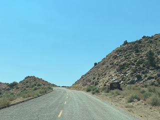
Horseshoe Meadows Road continues south and crosses over Carroll Creek at DeLaCour Ranch. Traffic is advised of 10 miles of rockfall zones ahead.


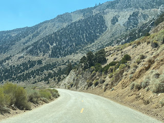
From Carroll Creek the Horseshoe Meadows Road ascends into the Sierra Nevada Mountains, enters Inyo National Forest, and hits the first switchback.


Horseshoe Meadows Road swings north towards switchback number two.


Horseshoe Meadows Road takes a southward swing towards switchback number three.


Horseshoe Meadows Road makes a northwest jog towards switchback number four.


Horseshoe Meadows Road makes a southern turn and then a western jog towards switchback number five.


Horseshoe Meadows Road makes a quick turn east towards switchback number six.


Horseshoe Meadows Road turns west and crests at about 9,500 feet before taking a dip in elevation towards Cottonwood Creek.


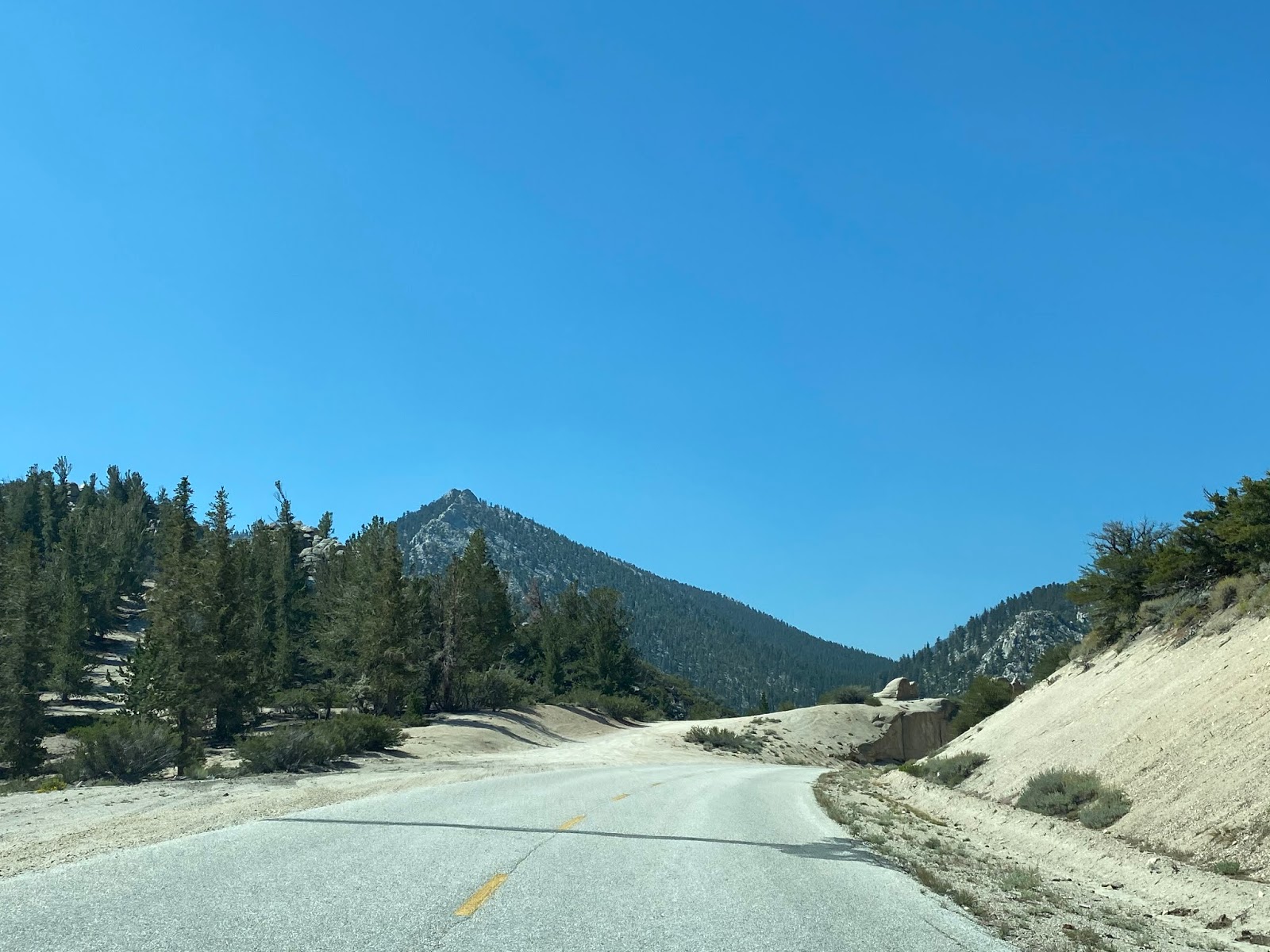


Horseshoe Meadows Road makes one more western climb at terminates at the campgrounds of Horseshoe Meadows at 10,072 feet above sea level.


Horseshoe Meadows lies at the confluence of numerous streams. From Horseshoe Meadows Mulky Pass can be seen to the south in the Golden Trout Wilderness. The Kern River Fault is only a couple miles westward which illustrates how far the Lone Pine-Porterville High Sierra Road really got to towards being completed.


Part 3; a drive down Horseshoe Meadows Road
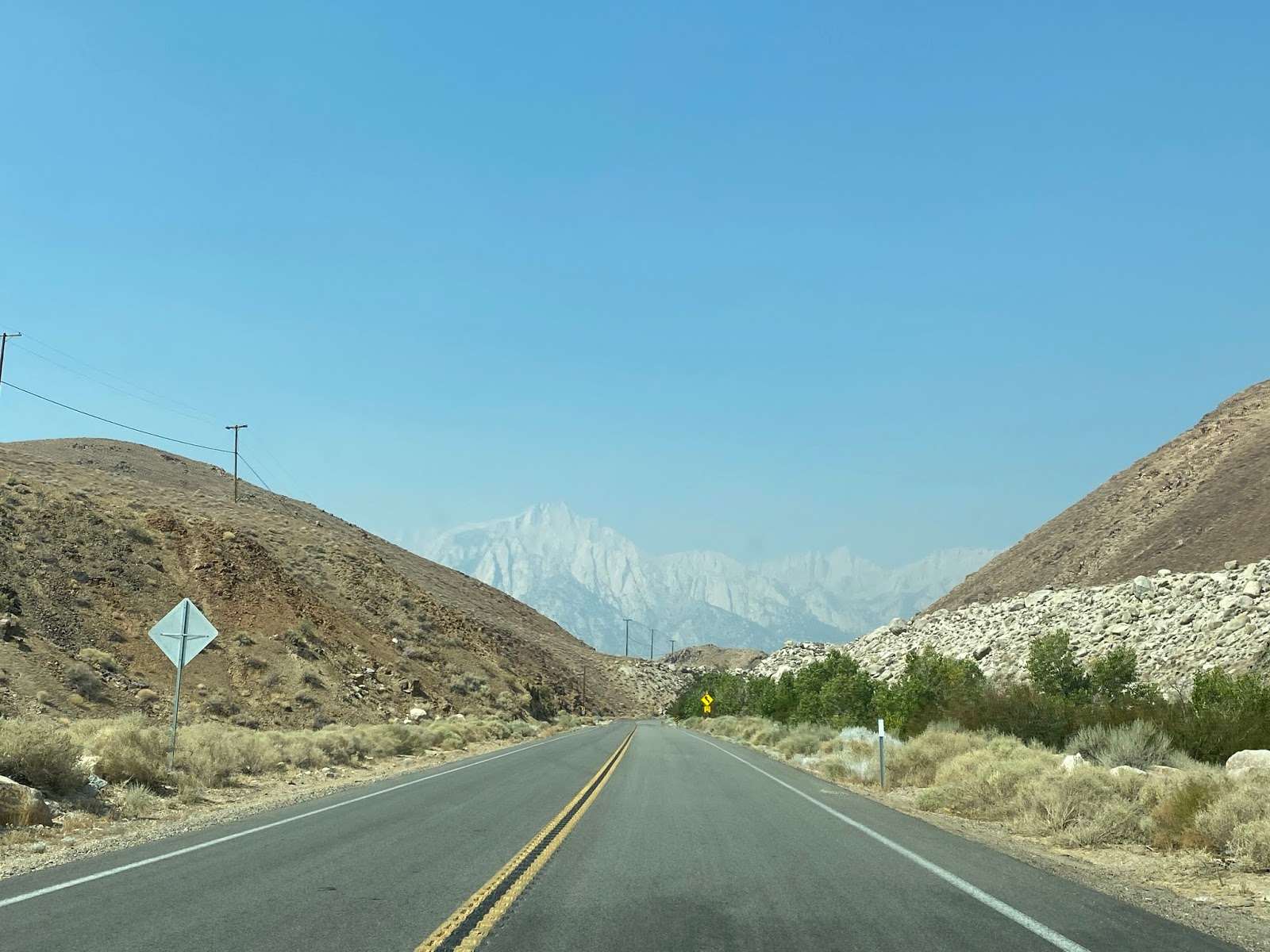
From Horseshoe Meadows traffic on Horseshoe Meadows Road is advised that Lone Pine is 20 miles away (which is actually closer to 24 miles).

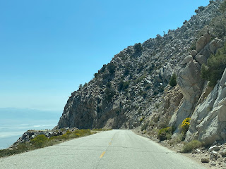
Horseshoe Meadows makes a brief descent before climbing back up to a vista of Owens Lake.


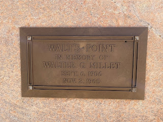
Horseshoe Meadows Road approaching switchback number six passes by Walt's Point which I'm to understand is used for a hang glider launch.


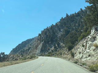
Horseshoe Meadows Road approaching switchback number six.


Horseshoe Meadows Road approaching switchback number five.


Horseshoe Meadows Road approaching switchback number four.


Horseshoe Meadows Road approaching switchback number three.


Horseshoe Meadows Road approaching switchback number two.


Horseshoe Meadows Road approaching switchback number one.


Horseshoe Meadows Road leaving Inyo National Forest and descending to Carroll Creek.


Horseshoe Meadows Road descending to Whitney Portal Road in the Alabama Hills.


In the previous Onion Valley Road article I made note of the operating conditions of the Challenger. Really I didn't find much notable to really say about the condition of my engine coolant heading uphill or brakes heading downhill on Horseshoe Meadows Road. The grade being only an average of 6.2% on Horseshoe Meadows Road versus an average of 7.8% on Onion Valley Road definitely was something that I can tell made the drive on the former much easier than the latter. Before returning to US Route 395 in Lone Pine I did take note of this oddity on Whitney Portal Road in the Alabama Hills.

Comments