When the US Route System was created during November 1926 the terminus of US Route 99 was located in El Centro via Imperial Avenue to US Route 80 at Adams Avenue. During June 1932, US Route 99 would be extended from El Centro to the Mexican Border in Calexico. US Route 99 would remain signed through El Centro until the highway was truncated to the southern end of the Golden State Freeway during June 1963. The blog examines the history of US Route 99 within the community of El Centro from inception to eventual replacement by California State Route 86. Pictured above as the blog cover is the multiplex of US Route 99 and US Route 80 on Main Street in downtown El Centro during the 1940s. US Route 99 from El Centro to the Mexican Border in Calexico can be seen in detail on the 1935 Division of Highways Map of Imperial County.
This blog is part of the larger Gribblenation US Route 99 Page. For more information pertaining to the other various segments of US Route 99 and it's three-digit child routes check out the link the below.
The history of US Route 99 in El Centro
El Centro lies within Imperial Valley of the Sonoran Desert near the Mexican Border with Sonora. El Centro was plotted out during 1906 by W.F. Holt and C.A. Barker amid the land boom of Imperial Valley. El Centro would ultimately beat Imperial for the Imperial County Seat when the lands of San Diego County were split on August 7, 1907. El Centro would go on to incorporate as a city on April 16, 1908.
What would become US Route 99 through El Centro was added to the State Highway System as part of the 1916 Second State Highway Bond Act in the form of
Legislative Route Number 26 (LRN 26). The initial definition of LRN 26 originated in San Bernardino and terminated in El Centro. The extension of LRN 26 to El Centro is referenced in the
1916 California Highway Bulletin.


The initial draft of the US Route System was approved by the Secretary of Agriculture during November of 1925. The US Route System within California was approved by California Highway Commission (CHC) with no changes recommended which can be seen in January 1926 California Highways & Public Works. US Route 99 is shown departing San Bernardino via LRN 26 towards a terminus at US Route 80 in El Centro.


Thusly planned US Route 99 appears on the 1925 Rand McNally Map of California following LRN 26 to a terminus in El Centro.

The US Route System was formally approved by the American Association of State Highway Engineers (AASHO) on November 11th, 1926. which formally brought US Route 99 into existence on LRN 26 in El Centro. As originally defined US Route 99 followed LRN 26 into El Centro via Imperial Avenue where it terminated at US Route 80/Adams Avenue.
The original terminus of US Route 99 at Imperial Avenue and Adams Avenue can be seen below in a 2018 Google Street View image.


1931 Legislative Chapter 82 extended LRN 26 to Colton and to the Mexican Border in Calexico. On September 8th, 1931, the California Division of Highways proposed an extension of US Route 99 from US Route 80 in El Centro south to the Mexican Border at Calexico. In the proposal letter by State Highway Engineer to the AASHO it is noted that the road through Heber and Calexico to the Mexican Border had been taken over as part of LRN 26 on August 14th, 1931. A temporary alignment of US Route 99/LRN 26 is stated to follow 4th Street south of US Route 80/Main Street in El Centro, Corfman Road, Heber Road through Heber, Imperial Avenue into downtown Calexico, 3rd Street and Heffernan Avenue in Calexico to the Mexican Border. The letter by the State Highway Engineer states a streamlined connecting highway north from Calexico to US Route 80/LRN 27 east of El Centro was planned as the future alignment of US Route 99/LRN 26.


The
August 1931 California Highways & Public Works announced 722 miles had been added to the State Highway System effective August 14th, 1931. The 10.05-mile extension of LRN 26 from El Centro to the Mexican Border in Calexico is noted in the mileage table and as item (p).
The AASHO Executive Committee on June 22nd, 1932, notified the California Division of Highways that US Route 99 was approved to be extended to the Mexican Border via the extension of LRN 26.
1933 Legislative Chapter 767 added LRN 201 to the State Highway System with the following definition:
"From a point on LRN 26 approximately 2 mi W of Brawley to a point on said LRN 26 approximately 2 1/2 mi SW of Brawley" and "Calipatria to Brawley-Holtville Road.
LRN 201 first appears on the 1934 Division of Highways Map with the more simplistic definition of "Route 187 near Calipatria to Route 26 east of Heber." Despite LRN 201 being adopted over the planned streamlined route of US Route 99 north of Calexico to US Route 80/LRN 27 near El Centro it never became part of the highway.
The multiplex of US Route 99 and US Route 80 on Main Street in El Centro can be seen in the below photo from the 1940s (courtesy Daniel Nauman).
The repaving of US Route 99/LRN 26 between Brawley-El Centro is cited in the
July/August 1946 California Highways & Public Works as being approved as a post-World War II project. The repaving project in the Brawley-El Centro corridor included new bridging structures.
The
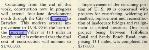
November/December 1948 California Highways & Public Works references the multiplex of US Route 99 and US Route 80 being realigned onto a bypass of downtown El Centro. The bypass of downtown El Centro began at the intersection of Main Street/4th Street and continued westward via a 4th Street and Adams Street to Imperial Highway. The article stub notes that a continuation project would expand US Route 99/LRN 26 to four lanes in Imperial north to Brawley.


The truncation of US Route 99 from Calexico to the junction of the Golden State Freeway and San Bernardino Freeway in Los Angeles was approved by the AASHO Executive Committee on June 19th, 1963. The justification by the California Division of Highways to truncate US Route 99 was to avoid what the agency viewed as confusing multiplexes on the new Interstate corridors of Southern California. The truncation of US Route 99 did not take effect until New Year's Day 1964 and was part of the run up to the 1964 State Highway Renumbering.
During the 1964 State Highway Renumbering numerous changes were made to the State Highway System. All the Legislative Route Numbers were dropped in favor of highway designations matching field signage. The former corridor of US Route 99 from Indio to El Centro was subsequently replaced with California State Route 86. California State Route 86 through El Centro first appears on the
1964 Division of Highways Map.


On October 9, 2013, Senate Bill 788, permitted the relinquishment of California State Route 86 within the cities of El Centro, Imperial and Brawley. To date the California Transportation Commission has not acted to formally relinquish California State Route 86 in El Centro.
Further Reading on US Route 99
Continuing south on US Route 99 to Heber, Calexico and the Mexican Border?
Continuing north on US Route 99 to Imperial?


Comments