
100th Christmas Tree Lane (Van Ness Boulevard, Fresno, California)


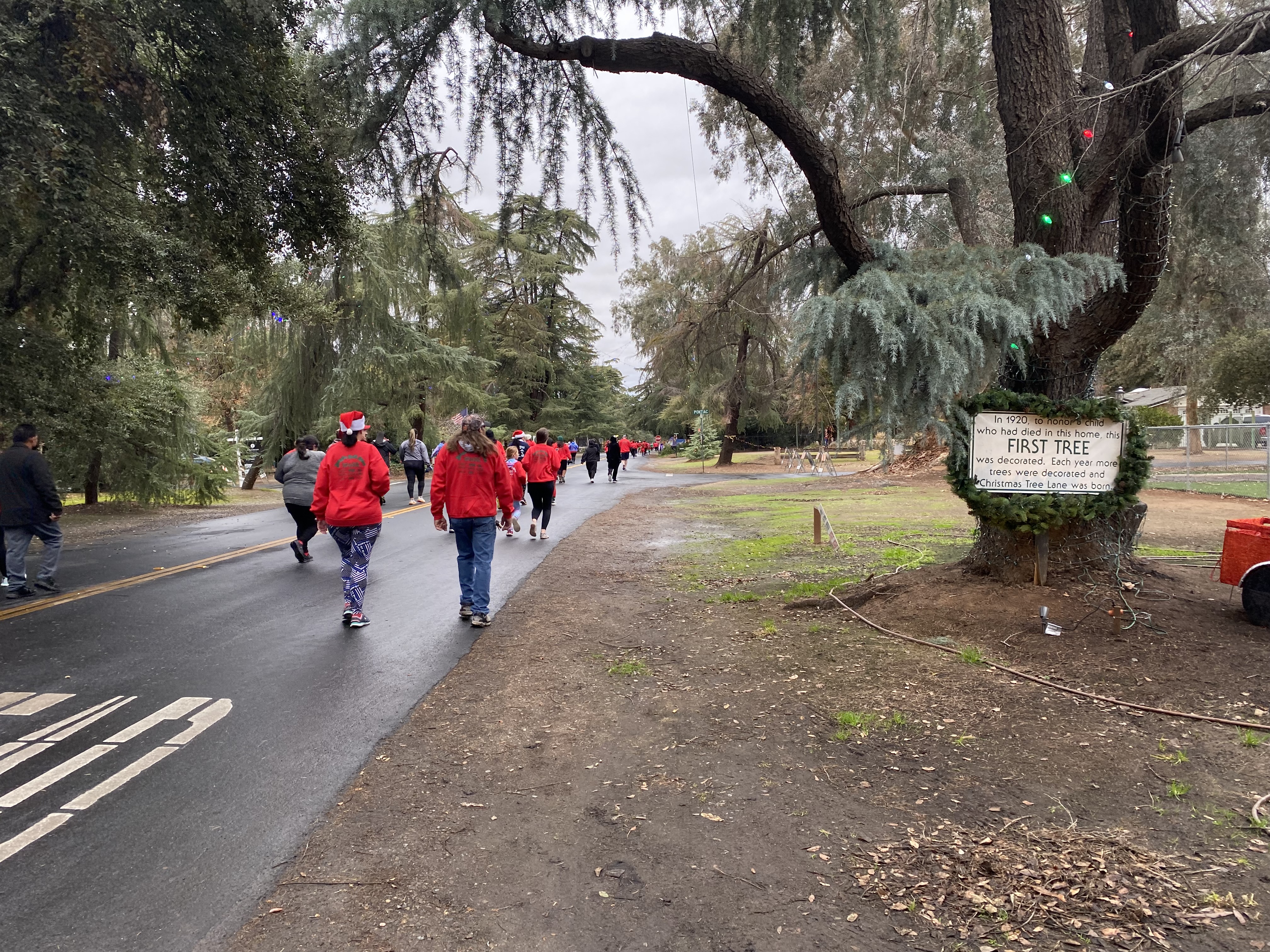
2022 marks the 100th Christmas Tree Lane which is held partially in the city of Fresno and Fresno County Island known as Fig Garden.  Christmas Tree Lane is held from the beginning of December to Christmas Day on Van Ness Boulevard between Shields Avenue to Shaw Avenue.  Van Ness Boulevard is adorned with Christmas lights above the roadway and most homeowners put emphasis on creating elaborate decorative displays.  Christmas Tree Lane began during 1920 following the death of a child who once lived along Van Ness Boulevard.  Christmas Tree Lane has only been interrupted by World War II during 1941 and an energy crisis during 1973.  

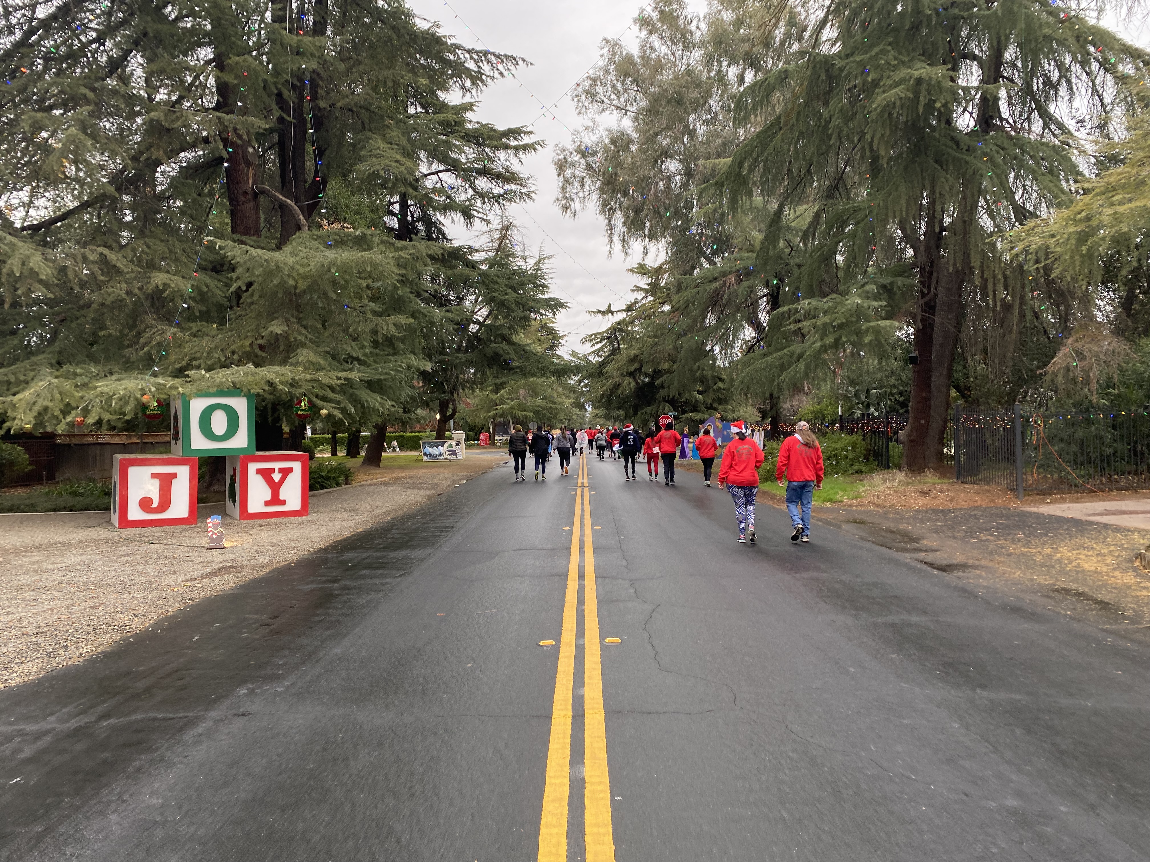
Christmas Tree Lane in the past typically has held time-night walking events.  These events have been cancelled since 2020 by the Fig Garden Homeowners Association in favor of one-way night-time drives on Van Ness Boulevard.  The only way to access Christmas Tree Lane reliably on foot with crowds since 2020 has been through the Jingle Bell 5K Run charity event.  

The Jingle Bell Run begins on Christmas Tree Lane near the terminus of Van Ness Boulevard just south of Shaw Avenue.  


The Jingle Bell Run loops via Rialto Avenue, Wilson Avenue and Lansing Way to the Fresno city limit at Herndon Canal Number 39 on Van Ness Boulevard.  A Christmas Lane shield has been installed on northbound Van Ness Boulevard which can be viewed at Herndon Canal Number 39.


Overhead Christmas Tree Lane signage can be found on Van Ness Boulevard immediately north of Herndon Canal Number 39.


The first tree to be decorated on Christmas Tree Lane during 1920 can be found at the southeast corner of Van Ness Boulevard and Pontiac Way. 


Various assorted Christmas displays on Van Ness Boulevard north towards the end of the Jingle Bell Run near Rialto Avenue.  


Comments

Popular posts from this blog

North Carolina Continues to Move Forward with Rail

2023 and the first half of 2024 have seen continued growth in North Carolina's passenger rail system.  From increased daily trains from Raleigh to Charlotte, federal funds for studying additional corridors, and receiving a historic grant to begin the construction of high-speed rail between Raleigh and Richmond, the last 18 months have been a flurry of activity at NCDOT's Rail Division.  And that's just the tip of the iceberg. As ridership and routes increase - the engine of North Carolina passenger rail trains will become a more common sight. (Adam Prince) Increased Passenger Train Service: On July 10, 2023, a fourth Piedmont round-trip rail service between Raleigh and Charlotte commenced.  The four Piedmont trains plus the daily Carolinian (to Washington, DC, and New York) bring the total of trains serving the two cities daily to five. The current daily Piedmont and Carolinian schedule between Charlotte and Raleigh (NCDOT) The result was over 641,000 passengers utilized pa

The Midway Palm and Pine of US Route 99

Along modern day California State Route 99 south of Avenue 11 just outside the City limits of Madera one can find the Midway Palm and Pine in the center median of the freeway.  The Midway Palm and Pine denotes the halfway point between the Mexican Border and Oregon State Line on what was US Route 99.  The Midway Palm is intended to represent Southern California whereas the Midway Pine is intended to represent Northern California.  Pictured above the Midway Palm and Pine can be seen from the northbound lanes of the California State Route 99 Freeway.   This blog is part of the larger Gribblenation US Route 99 Page.  For more information pertaining to the other various segments of US Route 99 and it's three-digit child routes check out the link the below. Gribblenation US Route 99 Page The history of the Midway Palm and Pine The true timeframe for when the Midway Palm and Pine (originally a Deadora Cedar Tree) were planted is unknown.  In fact, the origin of the Midway Palm and Pine w

US Route 101 in Benbow, Garberville and Redway

The communities of Benbow, Garberville and Redway can all be found along US Route 101 within southern Humboldt County.  The former surface alignment of US Route 101 in Garberville and Redway once crossed the Garberville Bluffs along what is now Redwood Drive via a corridor constructed as part of the Redwood Highway during the 1910s.  US Route 101 through Benbow, Garberville and Redway was modernized by 1935.  US Route 101 would eventually be upgraded to freeway standards in Benbow, Garberville and Redway by extension of the Redwood Freeway during 1966-68.  As the cover photo the original grade of US Route 101 and the Redwood Highway can be seen at the Garberville Bluffs during 1934.  US Route 101 can be seen in the communities of Benbow, Garberville and Redway on the 1935 Division of Highways Map of Humboldt County .   The history of US Route 101 in Benbow, Garberville and Redway Benbow, Garberville and Redway lie on the banks of the South Fork Eel River of southern Humboldt County.  D