
Former US Route 101 and California State Route 156 at San Juan Bautista Y


San Juan Bautista Y was once where US Route 101 and California State Route 156 intersected near the city of San Juan Bautista.  San Juan Bautista Y was constructed during 1935 as part of an extension of Legislative Route Number 22 west of San Juan Bautista to US Route 101 on the Prunedale Cutoff.  During 1938 California State Route 156 began to be signed at San Juan Bautista Y eastward towards Hollister.  The signature mission adobe walls, cross and campanile of San Juan Bautista Y were added to the junction also during 1938.  San Juan Bautista Y was bypassed upon the opening of the San Juan Interchange during June 1959.  San Juan Bautista Y has been preserved as something of an informal rest area.   


Part 1; the history of San Juan Bautista Y

The Gabilan Range between what is now San Juan Bautista and Salinas Valley was first explored during the second Juan Bautista De Anza Expedition of Las Californias.  The De Anza expedition likely crossed very close to the present alignment of Old Stage Road their exact path isn't clear.  Juan Bautista De Anza noted the following in his journal while passing near present-day San Juan Bautista on March 24, 1776:

"In the valley we saw many antelopes and white grey geese.  In the same valley we found an arroyo...and then came to a village in which I counted about twenty tule huts.  But the only two people we saw were two Indians who came out to the road and presented us with three fish more than a foot long."

In time the general route of the second De Anza Expedition became the path of El Camino Real ("The Royal Road").  The route of El Camino Real was intended to solidify a path of travel between the Catholic Missions of Las Californias.  In 1797 Mission San Juan Bautista was founded which led to a need for a spur of El Camino Real to be built from Salinas Valley over the Gabilan Range.  This spur of El Camino Real would become what is now Old Stage Road.  While the Spanish El Camino Real was largely just a general path between the Missions there are several paths such as Old Stage Road which can be identified conclusively as part of the highway.

In 1804 Alta California was formed out of the larger Las Californias.    El Camino Real would ultimately connect 21 Catholic Missions of Alta California ranging approximately 600 miles spanning from Mission San Diego de Alcala in San Diego north to Mission San Francisco Solano in Sonoma.  The Missions of El Camino Real were established from 1769 through 1823.  In the case of Mission San Francisco Solano, it was established two years after Mexico had won its independence from Spain in 1821.  Each Mission was meant to be approximately 30 miles apart from each other which would require a single day of travel by horseback.

Following the advent of Mexican independence from Spain the usage of the term "El Camino Real" largely fell into disuse.  Following the secularization of the Spanish Missions during August of 1833 the land holdings were split off into Ranchos.  Despite El Camino Real functionally no longer existing the route's path over what is now Old Stage Road remained a popular route of travel over the Gabilan Range.  What is now San Juan Bautista was founded as a town in 1834 known at the time as "San Juan de Castro."

Alta California was annexed by the United States in early 1848.  San Juan Bautista became an incorporated City in 1869 (citation; San Juan Bautista Historical Society).  San Juan Bautista was originally located in Monterey County but was among the land split into San Benito County in 1874.  Old Stage Road remained the primary route of travel between Salinas Valley and San Juan Bautista into the 20th Century.

Old Stage Road shows up numerous maps as a primitive road.  One such example is this 1857 Britton & Rey's Road Map of California.

Likewise Old Stage Road appears on the 1873 California Geological Survey Map of Central California as the road between Salinas Valley and San Juan Bautista.

In 1904 the American El Camino Real Association was formed with the goal to mark a modern highway that corresponded to the historical route between the Spanish Missions.  Ultimately the path of American El Camino Real was to be marked by the signature bells the corridor is known by today.  The first bell marking the American El Camino Real was placed in 1906 and it is estimated by 1915 that there may have been anywhere to 158 to 400 placed in-field.  The American El Camino Real was one of the earliest analogs of what would become the signed Auto Trails.  The American El Camino Real just as its Spanish predecessor crossed the Gabilan Range via Old Stage Road.  The background of the American El Camino Real is covered extensively on CAhighways.org.

CAhighyways.org on the American El Camino Real

The era of State Highway Maintenance through the Gablian Range would ultimately begin with the 1909 First State Highway Bond Act which was approved by voters in 1910.  One of the highways approved through the 1909 First State Highway Bond Act was a 481.8-mile highway originating at the City Limits of San Francisco which terminated in San Diego.  This highway would ultimately come to be known in time as Legislative Route Number 2 (LRN 2).

Old Stage Road even by the conventions of the 1910s was woefully inadequate for usage by automobiles.  The terrain of the Gabilan Range between San Juan Bautista and Salinas Valley was so rugged that an alternate route from Gilroy to Salinas by way of Watsonville and Castroville was considered.  The proposed highway routings of LRN 2 are featured in the January 1913 California Highway Bulletin.

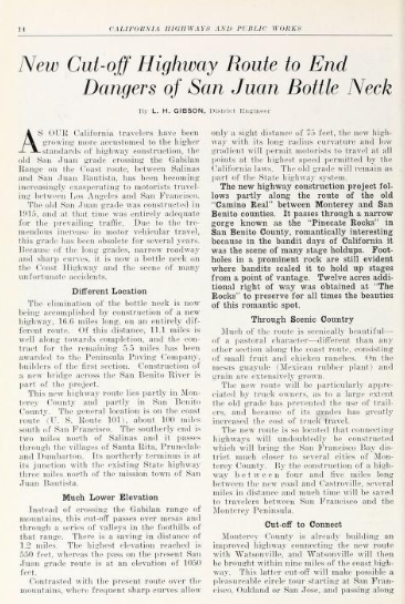
The rationale for selecting the routing of the San Juan Grade through the Gabilan Range (referenced as San Juan Mountain) is noted to be three-fold in the January 1913 California Highway Bulletin.  The route through the Gabilan Range was the most direct and particle route between Salinas Valley-Santa Clara Valley, within seven miles of the San Benito County seat of Hollister and had an estimated gradient ranging from 2-6%.  The existing route of American El Camino Real over Old Stage Road is noted to be direct, and it would be desirable for LRN 2 to follow nearby over a better grade.  


The January 1913 California Highway Bulletin noted $75,000 in bonds had been sold which funded construction of the San Juan Grade.  

The July 1914 California Highway Bulletin noted surveys for the San Juan Grade were complete in San Benito County and in Monterey County.  LRN 2 from the Monterey County Line to San Juan Bautista is noted to be in the process of construction as an unpaved road.  A contract to construct LRN 2 in paved Portland Cement north of San Juan Bautista is noted to have been awarded on July 6, 1914.  


The January 1915 California Highway Bulletin noted LRN 2 had been completed over the San Juan Grade from the Monterey County Line north to San Jaun Bautista.  The San Juan Grade despite not yet being paved immediately saw service as a replacement for Old Stage Road.  LRN 2 north of San Juan Bautista north to the Santa Clara County is cited to have gone through the process of a rejected contract and was now being constructed via prison labor.  


The January 1915 California Highway Bulletin noted the San Juan Grade from Salinas to the San Benito County line had been completed as an unpaved highway. 


LRN 2 on the then new San Juan Grade can be seen in contrast to Old Stage Road through the Gabilan Range on the 1917 California State Automobile Association Map.  


LRN 2 over the San Juan Grade can be seen as the 1920 Denny's Pocket Map of San Benito County.  Note: Old Stage Road is shown on the 1920 Denny's Map as an abandoned road.


The initial draft of the US Route System was approved by the Secretary of Agriculture during November of 1925.  The US Route System within California was approved by California Highway Commission with no changes recommended by January 1926.  The initial alignment of US Route 101 was planned to follow LRN 2 from San Francisco to San Diego via the San Juan Grade.  US Route 101 is shown on a map published in the 1926 California Highways & Public Works following LRN 2 south from San Francisco towards San Diego.


During November of 1926 the US Route System was approved by the American Association of State Highway Officials.  US Route 101 can be seen aligned through over the San Juan Grade and through San Juan Bautista on the 1926 Rand McNally Junior Map of California.  


The November 1929 California Highways & Public Works noted that asphalt sealant was being applied to portions of the San Juan Grade which had cracked Portland Cement.  It isn't fully clear when the San Juan Grade was paved in Portland Cement. 


The October 1931 California Highways & Public Works featured the construction of the Prunedale Cutoff which would replace the San Juan Grade as the new alignment of US Route 101/LRN 2.  The Prunedale Cutoff alignment of US Route 101/LRN 2 is noted to bypass San Juan Bautista by way of the communities of Santa Rita, Prunedale and Dumbarton.  The Prunedale Cutoff is noted to have a planned crossing of the Gabilan Range at 550 feet above sea level versus the 1,050-foot elevation used by the San Juan Grade.  The article notes the Prunedale Cutoff was anticipated to be opened to traffic during the summer of 1932.  


The April 1932 California Highways & Public Works noted the new alignment of US Route 101/LRN 2 was scheduled to open to traffic on July 1.  The article stub notes that the San Juan Grade would be retained as part of the State Highway System.  The Prunedale Cutoff alignment of US Route 101/LRN 2 is noted to pass by the former bandit's lair known as the Pinecate Rocks.  


The opening of the Prunedale Cutoff as the new alignment of US Route 101/LRN 2 was featured in the August 1932 California Highways & Public Works.  The Prunedale Cutoff was opened to traffic on July 20, 1932, upon the completion of a dedication ceremony.  The Prunedale Cutoff is shown to have a terminal elevation of 473 feet in the Gabilan Range compared to the 1,016 feet on the San Juan Grade. 


The Pincate Rocks can be seen below in a modern photo along the Prunedale Cutoff compared to a photo dated to 1932.  The Pincate Rocks once had an accessible picnic area which has since been blocked off by expansion of US Route 101 in the Prunedale Cutoff corridor to four-lane expressway standards.  


The San Juan Grade is shown to be retained as a spur of LRN 2 east of US Route 101 on the Prunedale Cutoff on the 1935 Division of Highways Map of San Benito County.  


The September 1935 California Highways & Public Works discusses the new route of LRN 22 west of San Juan Bautista to US Route 101/LRN 2 at the Prunedale Cutoff and new Y junction (the San Juan Bautista Y).  The original route of LRN 22 on Rocks Road is referred to as "a winding county road" that was immediately improved temporarily with an oiled earth application upon being adopted in 1933.  The new routing of LRN 22 west of San Jaun Bautista is noted to negate the need for traffic to use the original routing of US Route 101 via the San Juan Grade.  The San Juan Bautista Y is noted to be in line for future beautification which would include mission style walls, a campanile and a cross.  


The completion of LRN 22 west of San Juan Bautista led to the relinquishment of the San Juan Grade from the State Highway System.  The San Juan Grade no longer appears on the 1936-37 Division of Highways Map.   


The 1938 Division of Highways Map displays California State Route 156 being applied over LRN 22 between Hollister and San Juan Bautista Y.  


The January 1938 California Highways & Public Works features the completion of the cross and campanile at San Juan Bautista Y.  


The September/October 1959 California Highway & Public Works referenced the opening of the San Juan Interchange during June 1959 as a replacement for intersection of US Route 101/LRN 2 and California State Route 156/LRN 22 at San Juan Bautista Y.  The article stub notes San Juan Bautista Y had the highest rate of accidents of any state highway segment in San Benito County.  The cross and campanile of San Juan Bautista Y were preserved so they could be enjoyed by the traveling public.


Part 2; a visit to San Juan Bautista Y

The conventional way to visit San Juan Bautista Y is from northbound US Route 101.  San Juan Bautista Y can also be accessed from westbound California State Route 156 transition ramp to northbound US Route 101.  A large shoulder on the transition ramp to US Route 101 allows easy access to San Juan Bautista Y. 


The entire structure of San Juan Bautista Y is preserved as in a state similar to how it was prior to being bypassed during 1959.  The adobe walls, cross and campanile are all in good states of repair.  San Juan Bautista Y shows evidence of still being state maintained given a current Caltrans spec adopt a highway sign can be observed.  


Comments

Popular posts from this blog

The Pollasky Bridge

The Pollasky Bridge near modern day Friant is a ruined highway bridge which was completed during early 1906 as part of the Fresno-Fresno Flats Road.  The structure is one of the oldest known arch concrete spans to have been constructed in California.  The bridge briefly carried California State Route 41 following the destruction of the Lanes Bridge in 1940.  The Pollasky Bridge itself was destroyed by flooding during 1951, but the ruins can still be found on the Madera County side of the San Joaquin River.   Pictured as the blog cover is the Pollasky Bridge as it was featured in the 1913 book "The Concrete Bridge."  The structure can be seen crossing the San Joaquin River near Friant below on the 1922 United States Geological Survey Map.   Part 1; the history of the Pollasky Bridge The Pollasky Bridge site is near modern day Friant of Fresno County.  The community of Friant was established as Converse Ferry during 1852 on the San Joaquin Rive...

Trimmer Springs Road (Fresno County)

Trimmer Springs Road is an approximately forty-mile rural highway located in Fresno County.  The corridor begins near in California State Route 180 in Centerville and extends to Blackrock Road at the Kings River in the Sierra Nevada range near the Pacific Gas & Electric Company town of Balch Camp. The roadway is named after the former Trimmer Springs Resort and was originally constructed to facilitate access to the Sanger Log Flume.  Trimmer Springs Road was heavily modified and elongated after construction of Pine Flat Dam broke ground in 1947.   Part 1; the history of Trimmer Springs Road Much of the original alignment of Trimmer Springs Road was constructed to facilitate access to the Sanger Log Flume.   The  Kings River Lumber Company  had been established in 1888 in the form of a 30,000-acre purchase of forest lands in Converse Basin.  This purchase lied immediately west of Grant Grove and came to be known as "Millwood."  The co...

When was Ventura Avenue east of downtown Fresno renamed to Kings Canyon Road? (California State Route 180)

California State Route 180 was one of the original Sign State Routes designated in August 1934.  The highway east of Fresno originally utilized what was Ventura Avenue and Dunlap Road to reach what was then General Grant National Park.  By late year 1939 the highway was extended through the Kings River Canyon to Cedar Grove.   In 1940 General Grant National Park would be expanded and rebranded as Kings Canyon National Park.  The Kings Canyon Road designation first appeared in publications circa 1941 when the California State Route 180 bypass of Dunlap was completed.  Kings Canyon Road ultimately would replace the designation of Dunlap Road from Dunlap to Centerville and Ventura Avenue west to 1st Street in Fresno.   The Kings Canyon Road would remain largely intact until March 2023 when the Fresno Council designated Cesar Chavez Boulevard.  Cesar Chavez Boulevard was designated over a ten-mile corridor over what was Kings Canyon Road, remaini...