Buellton is a small City located in central Santa Barbara County along the Santa Ynez River. Prior to the modern freeway bypass being constructed US Route 101 was aligned through the City of Buellton on Avenue of the Flags. US Route 101 above can be seen facing northbound towards Pea Soup Andersen's in 1949. US Route 101 can be seen below aligned on Avenue of the Flags on the 1935 Division of Highways Map of Santa Barbara.
Part 1; the history of US Route 101 through Buellton
Buellton lies on land which was once part of Rancho San Carlos de Jonata which was mostly located in Santa Ynez Valley. During the mid-1860s R.T. Buell and his brother Alonzo Buell purchased a sizeable tract of land within Rancho San Carolos de Jonata. In 1872 R.T. Buell would purchase the entirety of Rancho San Carlos de Jonata and bought out his brother's stakes. By 1875 a small community develop around Buell Ranch on the Santa Ynez River. The town of
Buellton was not formally plotted out until 1920 when it was a long established locale on the Coast Highway of Legislative Route Number 2.
The era of State Highway Maintenance through Santa Ynez Valley would ultimately begin with the 1909 First State Highway Bond Act which was approved by voters in 1910. One of the highways approved through the 1909 First State Highway Bond Act was a 481.8 mile highway originating at the City Limits of San Francisco which terminated in San Diego. This highway would ultimately come to be known in time as
Legislative Route Number 2 ("LRN 2").
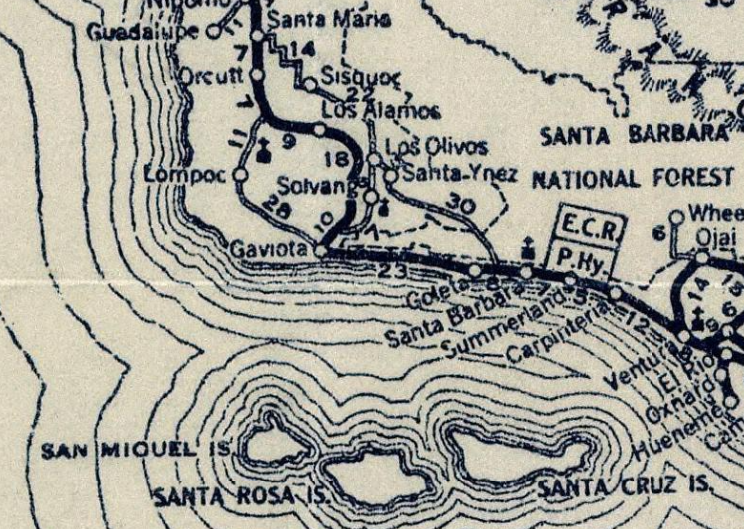
Unlike the previous Spanish El Camino Real and it's 1906 American Auto Trail successor the alignment of LRN 2 would diverge through Santa Ynez Valley reaching neither Mission La Purshima or Mission Santa Inés. Numerous suggested alignments of LRN 2 through Santa Ynez Valley can be seen on the
May 1913 California Highway Bulletin. Several of the suggested routes diverge west from Gaviota Pass towards Lompoc and Mission La Purshima. An easterly suggested route is shown to be aligned past Mission Santa Inés near Solvang. Ultimately a more central route through Santa Ynez Valley through Buell Ranch onward towards Zaca Canyon was selected as the alignment of LRN 2. In 1913 the Pacific Highway was plotted as a major Auto Trail which followed LRN 2 through Santa Ynez Valley.

Early LRN 2/American El Camino Real/Pacific Highway can be seen traversing Santa Ynez Valley via Buell Ranch on the
1917 California State Automobile Association Map.

The original Santa Ynez River Bridge on LRN 2 near Buell Ranch can be seen in this photo hosted on bridgehunter.com.
The 1920 Rand McNally Highway Map of California shows El Camino Real and the Pacific Highway following LRN 2 through Santa Ynez Valley through Buellton.
The 1924 Rand McNally Map of California shows the California Banff Bee-Line Highway co-signed with the Pacific Highway through Santa Ynez Valley and Buellton (displayed as "Buell").
The initial draft of the US Route System was approved by the Secretary of Agriculture during November of 1925. The US Route System with in California was approved by California Highway Commission with no changes recommended by
January 1926. The initial alignment of US Route 101 ("US 101") was planned to follow LRN 2 from San Francisco to San Diego via Buellton. US 101 is shown on a map published in the 1926 California Highways & Public Works following LRN 2 south from San Francisco towards San Diego.
The
September/October 1948 California Highways & Public Works discusses the ongoing rebuild and expansion of US 101/LRN 2 in Buellton via the so-called "Buellton Agreement." The Buellton Agreement is stated to include an expansion of US 101/LRN 2 on Avenue of the Flags to expressway standards (called "freeway" at the time) along with two new steel bridges at Nojoqui Creek and the Santa Ynez River.
The
November/December 1962 California Highways & Public Works lists a freeway bypass grade for US 101/LRN 2 being budgeted for the 1963-64 Fiscal Year.

In 1964 the Legislative Route Numbers were dropped as part of the State Highway Renumbering. LRN 2 through Buellton was subsequently legislatively redefined as simply part of US 101. The
July/August 1965 California Highways & Public Works features the completed Buellton Bypass Project. The Buellton Bypass opened on June 10th, 1965 and served to realign US 101 off Avenue of the Flags onto the new freeway grade. The Buellton Bypass began south of the Santa Ynez River and extended north around Buellton.
Part 2; a drive on former US Route 101 on Avenue of the Flags in Buellton
From modern US 101 southbound Avenue of the Flags can be accessed from Exit 140B.
A 1955 Chevrolet sitting for sale alongside Avenue of the Flags.
The former expressway grade of US 101 on Avenue of the Flags in Buellton as obvious as it heads south through Buellton to California State Route 246. Buellton would incorporate as a City on February 1st, 1992. Pea Soup Andersen's can be found at the northeast corner of Avenue of the Flags and California State Route 246. Pea Soup Andersen's traces it's origins to the opening of the Electric Cafe in 1924 and features a signature French pea soup recipe.
Avenue of the Flags continues south of California State Route 246 and crosses the 1948 Santa Ynez River Bridge. Upon crossing the Santa Ynez River the former alignment of US 101 becomes Santa Rosa Road and intersects the modern freeway grade.


Comments