Earlier in March I decided that I wanted a day of back road driving out in the Diablo Range. My destination was to Parkfield which took me on a path from California State Route 198 in Warthan Canyon southward via; the Parkfield Grade, Parkfield-Coalinga Road, and Cholame Road/Cholame Valley Road to CA 41/46 in Cholame Valley.

Previously I have written about Parkfield, the Parkfield Grade, and Parkfield-Coalinga Road. While I was happy regarding historic context of the original Parkfield article I didn't feel like I really captured the essence of reaching the community properly. The photos in the article below date back to a very dry summer of 2016.
Parkfield Grade/Parkfield-Coalinga Road
Part 1; the history of the Parkfield Grade, Parkfield-Coalinga Road, and Cholame Road/
The Parkfield Grade is an approximately 9.5 mile narrow paved road south from CA 198 in rural Fresno County over the crest of the Diablo Range to the Monterey County Line. At the Monterey County line the Parkfield Grade becomes Parkfield-Coalinga Road and continues another approximate 9.5 miles to the village of Parkfield located on the San Andreas Fault. From Parkfield-Coalinga Road the route of Cholame Road enters San Luis Obispo County and terminates at CA 41/46 after an approximately 17 mile course.

The Parkfield Grade and Parkfield-Coalinga Road appear to first have become a functional highway upon the completion of the Little Cholame Creek Bridge in 1915. The Parkfield Grade and Parkfield-Coalinga Road both appear on the 1917 California State Automobile Association Map of California. Interestingly Cholame Road doesn't appear on the 1917 CSAA Map and Vineland Canyon appears to have been the main highway connecting San Miguel to Parkfield. Regardless, Cholame Road functionally existed at the time given the Cholame Creek Bridge was constructed in 1910.

Part 2; a drive on the Parkfield Grade, Parkfield-Coalinga Road, and Cholame Road via Parkfield
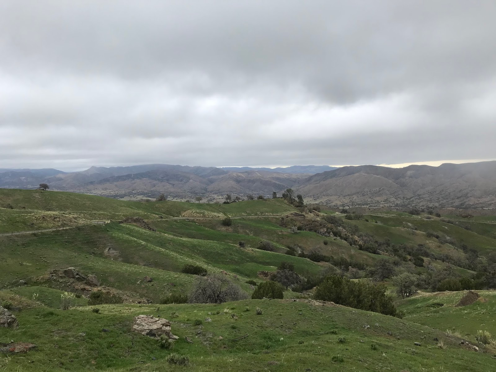
My approach to the Parkfield Grade was on CA 198 westbound towards Coalinga. Climbing over the Kettleman Hills revealed some ominous clouds hanging over the Diablo Range the Parkfield Grade.

CA 198 west/CA 33 south in Coalinga essentially was a ghost town which probably had a lot to do with all the news about the COVID-19 Coronavirus.

CA 198 west splits from CA 33 south in downtown Coalinga and enters the Diablo Range via Warthan Canyon. The warning regarding 7% grades was a welcome sight as it opens up into a really fun road to drive on.

Winding through Warthan Canyon on CA 198 west I encountered an oddity at Post Mile FRE 15.000 upon crossing Warthan Creek. Mysteriously a new staircase has appeared in the last couple months leading to a small religious monument. The Bureau of Land Management seemed none too pleased at the sudden appearance of the staircase.


CA 198 west intersects the Parkfield Grade at Post Mile FRE 12.50.


The Parkfield Grade beings by abruptly crossing Warthan Creek.


The Parkfield Grade flanks Warthan Creek before crossing it via a ford. The flood gauge at Warthan Creek shows a five foot height which would be a hell of a sight to see.


The Parkfield Grade crosses Warthan Creek a second time via ford.


The Parkfield Grade southbound begins to climb out of Warthan Canyon after the second ford of Warthan Creek.


The Parkfield Grade southbound makes a small descent and crosses Jacalitos Creek on another ford.


The Parkfield Grade begins it's long ascent to the crest of the Diablo Range. Most of the Parkfield Grade is cut directly into the face of the terrain and passes by some interesting rock formations.


The Parkfield Grade has a hell of a view of Warthan Canyon and Jacalitos Creek with very little tree cover.


Much of the Parkfield Grade has recently been repaved which makes for a surprisingly smooth one-lane climb up the Diablo Range. From the higher elevations of the Parkfield Grade one can see Coalinga and San Joaquin Valley.


The Parkfield Grade begins to approach the tree line where it enters open range.


The Parkfield Grade crests the 3,000 foot elevation line and reaches a small monument. The monument contains the history of the; Roberts Family, Motte Family, and some of the back story of the Parkfield Grade itself.


From the monument looking back northward reveals an unobstructed view of Warthan Canyon and San Joaquin Valley.


One last vista on the Parkfield Grade was had before I encountered the low hanging clouds.


At about the 3,200 foot elevation line I entered the tree line of the Parkfield Grade and cloud cover.


The Parkfield Grade southbound crosses a second cattle guard.


The Parkfield ascends to the crest of the Diablo Range at approximately 3,500 feet above sea level and enters Monterey County as the gravel Parkfield-Coalinga Road.


Parkfield-Coalinga Road has a quality gravel surface but also has a steep drop from the crest of the Diablo Range which I would speculate is a 10-15% grade. From the Monterey County Line the route of Parkfield-Coalinga Road quickly dipped below the cloud line.


Parkfield-Coalinga Road south continues to descend to Little Cholame Creek where it becomes paved at the first bridge crossing.


Parkfield-Coalinga Road crosses Little Cholame Creek a second time on a single lane bridge.


A third bridge over Little Cholame Creek quickly follows the second structure on Parkfield-Cholame Road southbound.


Parkfield-Coalinga Road next approaches the 1915 Little Cholame Creek Bridge nearing Parkfield. The 1915 Little Cholame Creek Bridge is a Pratt Through Truss design which is 113.9 feet in length.


Parkfield-Coalinga Road enters the community of Parkfield. Parkfield lies at an elevation of 1,530 feet above sea level and boasts a population of only 18 which essentially makes it a ghost town.


Parkfield was settled as "Russleville" in 1854 when California was still a new U.S. State. The modern name of Parkfield comes from the Post Office rejecting Russelville as the community name in 1884. Post Office service operated in Parkfield until 1954 before disbanding. Reportedly there was minor silver and coal mining boom in the late 19th century which raised the population of Parkfield apparently to approximately 900.
Today Parkfield is mostly known for being on top of the San Andreas Fault and having regular earthquakes of 6.0 in magnitude occurring roughly every 22 years. Most of the population in Parkfield is USGS employees living in somewhat modern housing. Cattle ranching (by way of V6 Ranch) surrounding Parkfield otherwise is the only real industry in the community.


On the southern outskirts of Parkfield the alignment of Parkfield-Coalinga Road crosses Little Cholame Creek over the San Andreas Fault and terminates at Cholame Road. There is a small placard denoting that Parkfield-Coalinga Road is crossing Little Cholame Creek over the San Andreas Fault to the Pacific Plate.


South of Parkfield the route of Cholame Road crosses Little Cholame Creek via the 1910 Cholame Creek Bridge. The Cholame Creek Bridge is located just north of Cholame Creek near where Little Cholame Creek merges into it. The Cholame Creek Bridge appears to be identical to the Little Cholame Creek Bridge and features an identical design with identical dimensions.


Cholame Road passes by Turkey Flat Road and Parkfield Cemetery Road. From Turkey Flat Road the community of Cholame is signed as 15 miles away.


Cholame Road winds through the terrain and crosses Cholame Creek where it becomes a conventional two-lane design.


Cholame Road enters Cholame Valley and winds through the ranch lands to San Luis Obispo County. At the San Luis Obispo County Line the route of Cholame Road becomes Cholame Valley Road.


Cholame Valley Road continues south to CA 41/CA 46 on the outskirts of the community of Cholame.


From Cholame Valley Road I turned east and stayed on CA 46 (former US 466) past James Dean Memorial Junction towards Polonio Pass. From Cholame Valley my destination was to the east in Famoso to track down the older alignments of; CA 65, US 99, and US 466.


Previously I have written about Parkfield, the Parkfield Grade, and Parkfield-Coalinga Road. While I was happy regarding historic context of the original Parkfield article I didn't feel like I really captured the essence of reaching the community properly. The photos in the article below date back to a very dry summer of 2016.
Parkfield Grade/Parkfield-Coalinga Road
Part 1; the history of the Parkfield Grade, Parkfield-Coalinga Road, and Cholame Road/
The Parkfield Grade is an approximately 9.5 mile narrow paved road south from CA 198 in rural Fresno County over the crest of the Diablo Range to the Monterey County Line. At the Monterey County line the Parkfield Grade becomes Parkfield-Coalinga Road and continues another approximate 9.5 miles to the village of Parkfield located on the San Andreas Fault. From Parkfield-Coalinga Road the route of Cholame Road enters San Luis Obispo County and terminates at CA 41/46 after an approximately 17 mile course.

The Parkfield Grade and Parkfield-Coalinga Road appear to first have become a functional highway upon the completion of the Little Cholame Creek Bridge in 1915. The Parkfield Grade and Parkfield-Coalinga Road both appear on the 1917 California State Automobile Association Map of California. Interestingly Cholame Road doesn't appear on the 1917 CSAA Map and Vineland Canyon appears to have been the main highway connecting San Miguel to Parkfield. Regardless, Cholame Road functionally existed at the time given the Cholame Creek Bridge was constructed in 1910.

Part 2; a drive on the Parkfield Grade, Parkfield-Coalinga Road, and Cholame Road via Parkfield
My approach to the Parkfield Grade was on CA 198 westbound towards Coalinga. Climbing over the Kettleman Hills revealed some ominous clouds hanging over the Diablo Range the Parkfield Grade.

CA 198 west/CA 33 south in Coalinga essentially was a ghost town which probably had a lot to do with all the news about the COVID-19 Coronavirus.

CA 198 west splits from CA 33 south in downtown Coalinga and enters the Diablo Range via Warthan Canyon. The warning regarding 7% grades was a welcome sight as it opens up into a really fun road to drive on.

Winding through Warthan Canyon on CA 198 west I encountered an oddity at Post Mile FRE 15.000 upon crossing Warthan Creek. Mysteriously a new staircase has appeared in the last couple months leading to a small religious monument. The Bureau of Land Management seemed none too pleased at the sudden appearance of the staircase.


CA 198 west intersects the Parkfield Grade at Post Mile FRE 12.50.


The Parkfield Grade beings by abruptly crossing Warthan Creek.


The Parkfield Grade flanks Warthan Creek before crossing it via a ford. The flood gauge at Warthan Creek shows a five foot height which would be a hell of a sight to see.


The Parkfield Grade crosses Warthan Creek a second time via ford.


The Parkfield Grade southbound begins to climb out of Warthan Canyon after the second ford of Warthan Creek.


The Parkfield Grade southbound makes a small descent and crosses Jacalitos Creek on another ford.


The Parkfield Grade begins it's long ascent to the crest of the Diablo Range. Most of the Parkfield Grade is cut directly into the face of the terrain and passes by some interesting rock formations.


The Parkfield Grade has a hell of a view of Warthan Canyon and Jacalitos Creek with very little tree cover.


Much of the Parkfield Grade has recently been repaved which makes for a surprisingly smooth one-lane climb up the Diablo Range. From the higher elevations of the Parkfield Grade one can see Coalinga and San Joaquin Valley.


The Parkfield Grade begins to approach the tree line where it enters open range.


The Parkfield Grade crests the 3,000 foot elevation line and reaches a small monument. The monument contains the history of the; Roberts Family, Motte Family, and some of the back story of the Parkfield Grade itself.


From the monument looking back northward reveals an unobstructed view of Warthan Canyon and San Joaquin Valley.


One last vista on the Parkfield Grade was had before I encountered the low hanging clouds.


At about the 3,200 foot elevation line I entered the tree line of the Parkfield Grade and cloud cover.


The Parkfield Grade southbound crosses a second cattle guard.


The Parkfield ascends to the crest of the Diablo Range at approximately 3,500 feet above sea level and enters Monterey County as the gravel Parkfield-Coalinga Road.


Parkfield-Coalinga Road has a quality gravel surface but also has a steep drop from the crest of the Diablo Range which I would speculate is a 10-15% grade. From the Monterey County Line the route of Parkfield-Coalinga Road quickly dipped below the cloud line.


Parkfield-Coalinga Road south continues to descend to Little Cholame Creek where it becomes paved at the first bridge crossing.


Parkfield-Coalinga Road crosses Little Cholame Creek a second time on a single lane bridge.


A third bridge over Little Cholame Creek quickly follows the second structure on Parkfield-Cholame Road southbound.


Parkfield-Coalinga Road next approaches the 1915 Little Cholame Creek Bridge nearing Parkfield. The 1915 Little Cholame Creek Bridge is a Pratt Through Truss design which is 113.9 feet in length.


Parkfield-Coalinga Road enters the community of Parkfield. Parkfield lies at an elevation of 1,530 feet above sea level and boasts a population of only 18 which essentially makes it a ghost town.


Parkfield was settled as "Russleville" in 1854 when California was still a new U.S. State. The modern name of Parkfield comes from the Post Office rejecting Russelville as the community name in 1884. Post Office service operated in Parkfield until 1954 before disbanding. Reportedly there was minor silver and coal mining boom in the late 19th century which raised the population of Parkfield apparently to approximately 900.
Today Parkfield is mostly known for being on top of the San Andreas Fault and having regular earthquakes of 6.0 in magnitude occurring roughly every 22 years. Most of the population in Parkfield is USGS employees living in somewhat modern housing. Cattle ranching (by way of V6 Ranch) surrounding Parkfield otherwise is the only real industry in the community.


On the southern outskirts of Parkfield the alignment of Parkfield-Coalinga Road crosses Little Cholame Creek over the San Andreas Fault and terminates at Cholame Road. There is a small placard denoting that Parkfield-Coalinga Road is crossing Little Cholame Creek over the San Andreas Fault to the Pacific Plate.


South of Parkfield the route of Cholame Road crosses Little Cholame Creek via the 1910 Cholame Creek Bridge. The Cholame Creek Bridge is located just north of Cholame Creek near where Little Cholame Creek merges into it. The Cholame Creek Bridge appears to be identical to the Little Cholame Creek Bridge and features an identical design with identical dimensions.


Cholame Road passes by Turkey Flat Road and Parkfield Cemetery Road. From Turkey Flat Road the community of Cholame is signed as 15 miles away.


Cholame Road winds through the terrain and crosses Cholame Creek where it becomes a conventional two-lane design.


Cholame Road enters Cholame Valley and winds through the ranch lands to San Luis Obispo County. At the San Luis Obispo County Line the route of Cholame Road becomes Cholame Valley Road.


Cholame Valley Road continues south to CA 41/CA 46 on the outskirts of the community of Cholame.


From Cholame Valley Road I turned east and stayed on CA 46 (former US 466) past James Dean Memorial Junction towards Polonio Pass. From Cholame Valley my destination was to the east in Famoso to track down the older alignments of; CA 65, US 99, and US 466.


Comments