After leaving Black Canyon of the Gunnison National Park I returned to US Route 50 via Colorado State Route 347. I traveled west on US 50 towards Montrose to reach US 550. My route ahead was south over the San Juan Mountains via; US 550, the Million Dollar Highway, and San Juan Skyway.

This article serves as the 22nd entry in the 2016 Summer Mountain Trip Series. Part 21 regarding CO 347, South Rim Road, and Black Canyon of the Gunnison National Park can be found below:
2016 Summer Mountain Trip Part 21; CO 347, South Rim Road, and Black Canyon of the Gunnison National Park
US 550 over the San Juan Mountains is one of the most well known scenic highways in Colorado and is a segment of the 233 mile San Juan Skyway. US 550 is mostly known for the narrow segment of highway from Ouray south over Red Mountain Pass to Silverton. This segment of US 550 between Ouray and Silverton is known historically as the "Million Dollar Highway."
The origins of the Million Dollar Highway date back to 1883 when Otto Mears completed a toll road from Ouray south to Ironton. A second toll road facility was soon constructed from Ironton south over Red Mountain Pass to Silverton. Otto Mears later became involved with the construction of the Silverton Railroad. The Silverton Railroad was a narrow gauge line that began construction in 1887. The Silverton Railroad branched off from the Denver & Rio Grande Railroad at Mineral Creek where it ascended northward to Red Mountain Pass. The Silverton Railroad reached the town of Albany located north of Ironton in September of 1889. The 1882 New Railroad and County Map of Colorado shows the Denver & Rio Grande Railroad reaching Silverton just prior to the construction of the Silverton Railroad.

A continuation of the Silverton Railroad from Albany to Ouray was proposed in 1892 which would have had to traverse the 7% grades of Uncompahgre Gorge. These plans were scrapped following the 1893 Silver Crash. The Silverton Railroad lingered on following the 1893 Silver Crash before being sold in a foreclosure sale in 1904. The reorganized Silverton Railroad ultimately shuttered for good in 1926.
During the early 1920s the Otto Mears toll facilities were rebuilt for automotive usage. The rebuilt roadways from Ouray south to Silverton were completed by 1924. The expense of the construction was considerable for the time which is likely the reason it came to be known as the "Million Dollar Highway." The newly completed highway from Ouray south to Silverton can be seen on a 1924 Rand McNally sectional map.

In late 1926 the US Route System was created. US 550 was plotted from US 50 in Montrose south to US 450 in Durango. US 550 can be seen on the 1927 Rand McNally Highway Map of Colorado where it is shown to also be Colorado State Route 19.

I approached US 550 south from Main Street in Montrose at the junction of CO 90. Montrose is the County Seat of the namesake Montrose County and is located on the Uncompahgre River. Montrose was established in 1882 as a rail siding of the Denver & Rio Grande Railroad.

US 550 south of Montrose follows the Uncompahgre River and crosses into Ouray County. Approximately 12 miles south of Montrose US 550 passes by the near ghost town of Colona. Colona is accessed from US 550 via Ouray County Route 1 and has a couple remaining structures that appear to be from the mining heyday of the region. Colona likely was never much more than a rail spur of a branch line of the Denver & Rio Grande Railroad which operated south from Montrose to Ouray.


South of Colona US 550 passes through Eldredge, the eastern bank of the Ridgway Reservoir in Ridgway State Park, and the community of Dallas. Approximately 14 miles south of Colona US 550 picks up the San Juan Skyway at the junction of CO 62 in Ridgway.
Ridgway's history began in 1891 as the north terminus of the Rio Grande Southern Railroad where it met a Denver & Rio Grande Spur out of Montrose. The Rio Grande Southern Railroad was a narrow gauge line which operated from 1891 through 1953. The Rio Grande Southern Railroad was routed through Telluride and Pico en route to Durango which also had a spur line to Silverton. After 1953 the line north out of Ridgway to Montrose was converted to standard gauge, before being ultimately abandoned in 1976. Ridgway apparently was once planned to be flooded over as part of the Ridgway Reservoir project until the planned dam was moved downstream on the Uncompahgre River. Ridgway today mostly seems to serves tourists traveling on US 550 and the San Juan Skyway but still has a distinct railroad motif.


South of Ridgway the Uncompahgre Gorge can be seen from US 550.

US 550 south of Ridgway passes through the community of Portland. Ouray lies approximately 10 miles south of Ridgway on US 550. Within Ouray US 550 is signed on Main Street.
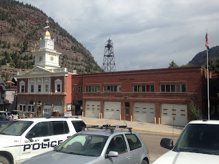
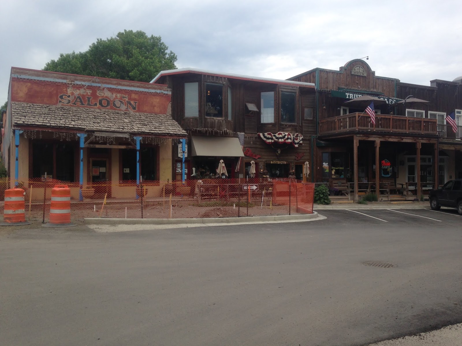
Ouray is the County Seat of Ouray County and generally considered to be one of the notable mining towns in Colorado. Ouray was settled in 1875 by prospectors looking for mineral wealth in Uncompahgre Gorge. Ouray was incorporated for the first time in October 1876 and became the Ouray County seat the following year. The Denver & Rio Grande Railroad arrived in Ouray in 1887 and during it's peak had about 30 mines located nearby. Ouray peaked around a population of about 2,500 and was one of the first communities in Colorado to have what might be considered "suburbs" to the south in Uncompahgre Gorge. By 1930 the Denver & Rio Grande shuttered passenger service to Ouray and the line was ultimately pulled by 1953.
Ouray today along with US 550 on Main Street retain a classing "mining boom" feel. Ouray lies at an elevation of 7,792 feet above sea level and boasts an approximate population of 1,000.


US 550 south of Ouray immediately begins a massive 7% ascent on the Million Dollar Highway. Suffice to say some of the views of Ouray from US 550 are quite striking.


US 550 south begins to ascend into Uncompahgre Gorge and passes through a tunnel which is crested by the Mineral Creek Trail.

US 550 has a viewing platform of Bear Creek Falls which contains a plaque dedicated to Otto Mears.


The viewing platform of Bear Creek Falls gives a good idea how steep Uncompahgre Gorge really is.


US 550 on the Million Dollar Highway is often noted for the segment through Uncomphagre Gorge due to it having no guard rail and a steep drop off. From a car the cliff isn't too intimidating but I would imagine it would be quite different hauling runs in the winter in a semi.

A look northbound on US 550 through Uncomphagre Gorge.

US 550 south splits from the Uncomphagre River and begins to follow Red Mountain Creek. At Crystal Lake the terrain of US 550 flattens. The remains of the ghost town Alabany can be found at Crystal Lake.


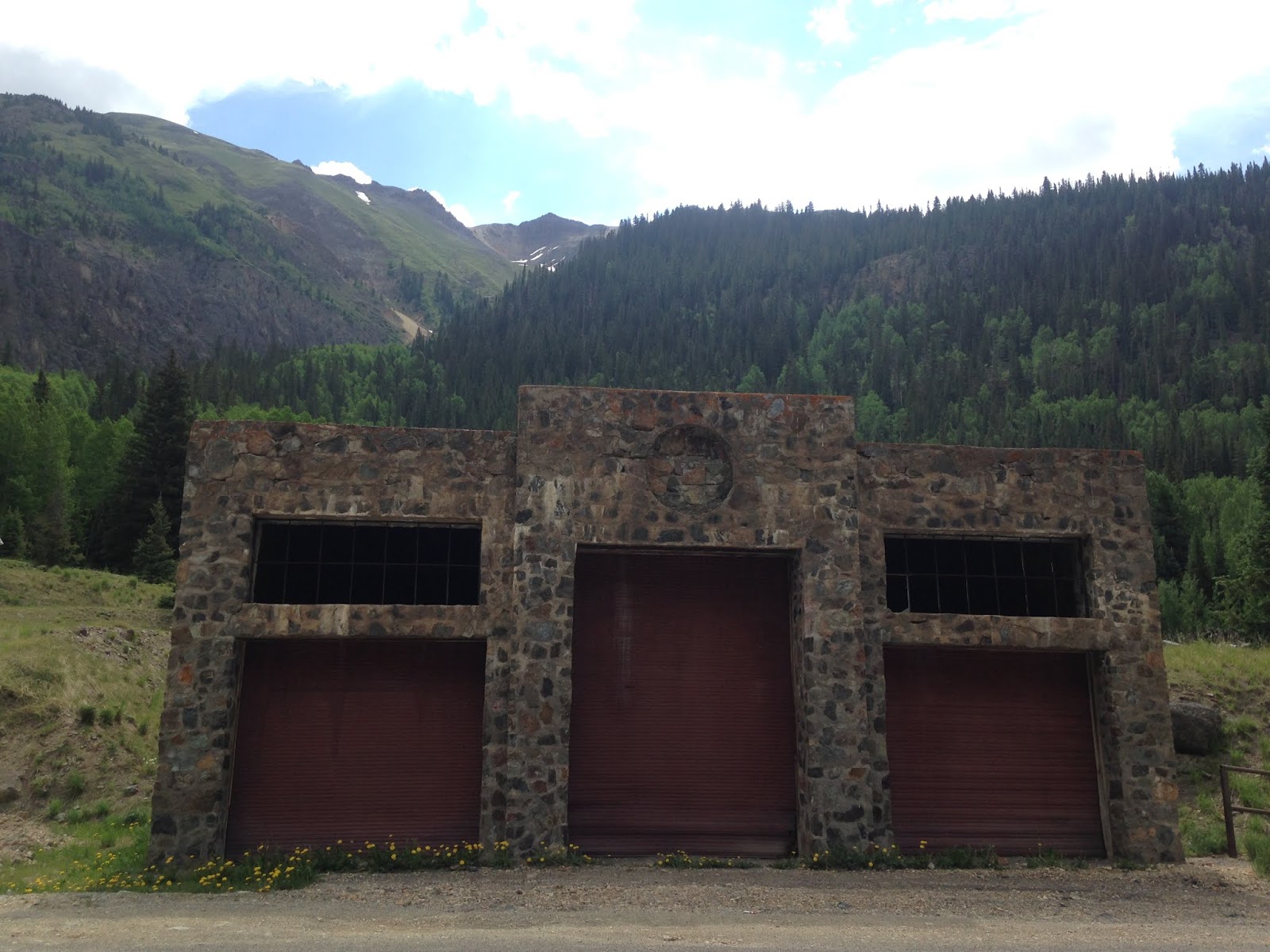
The ruins of Ironton can be found along US 550 approximately 8.6 miles south of Ouray. Ironton once had a population of about 1,000 during it's heyday in the silver mining boom of Red Mountain Pass.


Just north of Red Mountain Pass there is an overlook of the Idarado Mine. There is a historic plaque that discuss the histories of the communities of; Albany, Ironton, Guston, Red Mountain Town, Congress, and Chattanooga. Another plaque provides an overview of the history of the Idarado Mine. An overview map shows where most of the mines, mining communities, infrastructure and Silverton Railroad Grade are located.


Some of the ruins of the Idarado Mine can be found immediately west of US 550.


US 550 southbound ascends 4.6 miles from Ironton to the 11,018 foot Red Mountain Pass. Red Mountain Pass serves as the San Juan County Line. I ended up stuck at Red Mountain Pass due to road construction and took a minute to walk uphill.


From Red Mountain Pass US 550 southbound begins to follow Mineral Creek. US 550 follows Mineral Creek for approximately 10 miles before entering the outskirts of Silverton. I made a detour into downtown Silverton via Greene Street. Silverton lies at an elevation of approximately 9,300 feet above sea level and is the San Juan County Seat.

Silverton is located on the Animas River at the confluence of Mineral Creek. Placer miners found traces of gold upstream on the Animas River at the present Eureka ghost town site in 1860. The placer miners were forced out by the local Ute Tribe in 1861. Prospectors returned in 1871 and found a large gold strike at Arrastre Gulch. A treaty was struck with the Utes in 1873 which opened up part of their land to mining. Numerous additional mineral claims were made in the area and Silverton was established in 1874. By 1881 the Duragno & Silverton Narrow Gauge Railroad brought trains to Silverton. Unlike almost all the other communities in the San Juan Mountains the mines around Silverton managed to stay open past the 1893 Silver Crash. Silverton still has some active mining in the area and the Durango & Silverton Railroad still operates as a tourism line.
Silverton much like Ouray is a true throwback to a different era when mining was one of the key industries in Colorado..


South of Silverton US 550 ascends 7 miles to the Molas Pass. Molas Pass is a much more gradual climb than Red Mountain Pass and lies at an elevation of 10,910 feet above sea level.


From Molas Pass the route of US 550 south to Durango isn't anywhere near as dramatic as it was between Ouray and Silverton. US 550 enters La Plata County and reaches US 160 approximately 49 miles south of Silverton in downtown Durango. US 550 and US 160 briefly multiplex south of downtown Durango. I made an eastern turn on US 160 towards Wolf Creek Pass.
2016 Summer Mountain Trip Part 23; US Route 160 over Wolf Creek Pass

This article serves as the 22nd entry in the 2016 Summer Mountain Trip Series. Part 21 regarding CO 347, South Rim Road, and Black Canyon of the Gunnison National Park can be found below:
2016 Summer Mountain Trip Part 21; CO 347, South Rim Road, and Black Canyon of the Gunnison National Park
US 550 over the San Juan Mountains is one of the most well known scenic highways in Colorado and is a segment of the 233 mile San Juan Skyway. US 550 is mostly known for the narrow segment of highway from Ouray south over Red Mountain Pass to Silverton. This segment of US 550 between Ouray and Silverton is known historically as the "Million Dollar Highway."
The origins of the Million Dollar Highway date back to 1883 when Otto Mears completed a toll road from Ouray south to Ironton. A second toll road facility was soon constructed from Ironton south over Red Mountain Pass to Silverton. Otto Mears later became involved with the construction of the Silverton Railroad. The Silverton Railroad was a narrow gauge line that began construction in 1887. The Silverton Railroad branched off from the Denver & Rio Grande Railroad at Mineral Creek where it ascended northward to Red Mountain Pass. The Silverton Railroad reached the town of Albany located north of Ironton in September of 1889. The 1882 New Railroad and County Map of Colorado shows the Denver & Rio Grande Railroad reaching Silverton just prior to the construction of the Silverton Railroad.

A continuation of the Silverton Railroad from Albany to Ouray was proposed in 1892 which would have had to traverse the 7% grades of Uncompahgre Gorge. These plans were scrapped following the 1893 Silver Crash. The Silverton Railroad lingered on following the 1893 Silver Crash before being sold in a foreclosure sale in 1904. The reorganized Silverton Railroad ultimately shuttered for good in 1926.
During the early 1920s the Otto Mears toll facilities were rebuilt for automotive usage. The rebuilt roadways from Ouray south to Silverton were completed by 1924. The expense of the construction was considerable for the time which is likely the reason it came to be known as the "Million Dollar Highway." The newly completed highway from Ouray south to Silverton can be seen on a 1924 Rand McNally sectional map.

In late 1926 the US Route System was created. US 550 was plotted from US 50 in Montrose south to US 450 in Durango. US 550 can be seen on the 1927 Rand McNally Highway Map of Colorado where it is shown to also be Colorado State Route 19.

I approached US 550 south from Main Street in Montrose at the junction of CO 90. Montrose is the County Seat of the namesake Montrose County and is located on the Uncompahgre River. Montrose was established in 1882 as a rail siding of the Denver & Rio Grande Railroad.

US 550 south of Montrose follows the Uncompahgre River and crosses into Ouray County. Approximately 12 miles south of Montrose US 550 passes by the near ghost town of Colona. Colona is accessed from US 550 via Ouray County Route 1 and has a couple remaining structures that appear to be from the mining heyday of the region. Colona likely was never much more than a rail spur of a branch line of the Denver & Rio Grande Railroad which operated south from Montrose to Ouray.


South of Colona US 550 passes through Eldredge, the eastern bank of the Ridgway Reservoir in Ridgway State Park, and the community of Dallas. Approximately 14 miles south of Colona US 550 picks up the San Juan Skyway at the junction of CO 62 in Ridgway.
Ridgway's history began in 1891 as the north terminus of the Rio Grande Southern Railroad where it met a Denver & Rio Grande Spur out of Montrose. The Rio Grande Southern Railroad was a narrow gauge line which operated from 1891 through 1953. The Rio Grande Southern Railroad was routed through Telluride and Pico en route to Durango which also had a spur line to Silverton. After 1953 the line north out of Ridgway to Montrose was converted to standard gauge, before being ultimately abandoned in 1976. Ridgway apparently was once planned to be flooded over as part of the Ridgway Reservoir project until the planned dam was moved downstream on the Uncompahgre River. Ridgway today mostly seems to serves tourists traveling on US 550 and the San Juan Skyway but still has a distinct railroad motif.


South of Ridgway the Uncompahgre Gorge can be seen from US 550.

US 550 south of Ridgway passes through the community of Portland. Ouray lies approximately 10 miles south of Ridgway on US 550. Within Ouray US 550 is signed on Main Street.
Ouray is the County Seat of Ouray County and generally considered to be one of the notable mining towns in Colorado. Ouray was settled in 1875 by prospectors looking for mineral wealth in Uncompahgre Gorge. Ouray was incorporated for the first time in October 1876 and became the Ouray County seat the following year. The Denver & Rio Grande Railroad arrived in Ouray in 1887 and during it's peak had about 30 mines located nearby. Ouray peaked around a population of about 2,500 and was one of the first communities in Colorado to have what might be considered "suburbs" to the south in Uncompahgre Gorge. By 1930 the Denver & Rio Grande shuttered passenger service to Ouray and the line was ultimately pulled by 1953.
Ouray today along with US 550 on Main Street retain a classing "mining boom" feel. Ouray lies at an elevation of 7,792 feet above sea level and boasts an approximate population of 1,000.


US 550 south of Ouray immediately begins a massive 7% ascent on the Million Dollar Highway. Suffice to say some of the views of Ouray from US 550 are quite striking.


US 550 south begins to ascend into Uncompahgre Gorge and passes through a tunnel which is crested by the Mineral Creek Trail.

US 550 has a viewing platform of Bear Creek Falls which contains a plaque dedicated to Otto Mears.


The viewing platform of Bear Creek Falls gives a good idea how steep Uncompahgre Gorge really is.


US 550 on the Million Dollar Highway is often noted for the segment through Uncomphagre Gorge due to it having no guard rail and a steep drop off. From a car the cliff isn't too intimidating but I would imagine it would be quite different hauling runs in the winter in a semi.

A look northbound on US 550 through Uncomphagre Gorge.

US 550 south splits from the Uncomphagre River and begins to follow Red Mountain Creek. At Crystal Lake the terrain of US 550 flattens. The remains of the ghost town Alabany can be found at Crystal Lake.


The ruins of Ironton can be found along US 550 approximately 8.6 miles south of Ouray. Ironton once had a population of about 1,000 during it's heyday in the silver mining boom of Red Mountain Pass.


Just north of Red Mountain Pass there is an overlook of the Idarado Mine. There is a historic plaque that discuss the histories of the communities of; Albany, Ironton, Guston, Red Mountain Town, Congress, and Chattanooga. Another plaque provides an overview of the history of the Idarado Mine. An overview map shows where most of the mines, mining communities, infrastructure and Silverton Railroad Grade are located.


Some of the ruins of the Idarado Mine can be found immediately west of US 550.


US 550 southbound ascends 4.6 miles from Ironton to the 11,018 foot Red Mountain Pass. Red Mountain Pass serves as the San Juan County Line. I ended up stuck at Red Mountain Pass due to road construction and took a minute to walk uphill.


From Red Mountain Pass US 550 southbound begins to follow Mineral Creek. US 550 follows Mineral Creek for approximately 10 miles before entering the outskirts of Silverton. I made a detour into downtown Silverton via Greene Street. Silverton lies at an elevation of approximately 9,300 feet above sea level and is the San Juan County Seat.

Silverton is located on the Animas River at the confluence of Mineral Creek. Placer miners found traces of gold upstream on the Animas River at the present Eureka ghost town site in 1860. The placer miners were forced out by the local Ute Tribe in 1861. Prospectors returned in 1871 and found a large gold strike at Arrastre Gulch. A treaty was struck with the Utes in 1873 which opened up part of their land to mining. Numerous additional mineral claims were made in the area and Silverton was established in 1874. By 1881 the Duragno & Silverton Narrow Gauge Railroad brought trains to Silverton. Unlike almost all the other communities in the San Juan Mountains the mines around Silverton managed to stay open past the 1893 Silver Crash. Silverton still has some active mining in the area and the Durango & Silverton Railroad still operates as a tourism line.
Silverton much like Ouray is a true throwback to a different era when mining was one of the key industries in Colorado..


South of Silverton US 550 ascends 7 miles to the Molas Pass. Molas Pass is a much more gradual climb than Red Mountain Pass and lies at an elevation of 10,910 feet above sea level.


From Molas Pass the route of US 550 south to Durango isn't anywhere near as dramatic as it was between Ouray and Silverton. US 550 enters La Plata County and reaches US 160 approximately 49 miles south of Silverton in downtown Durango. US 550 and US 160 briefly multiplex south of downtown Durango. I made an eastern turn on US 160 towards Wolf Creek Pass.
2016 Summer Mountain Trip Part 23; US Route 160 over Wolf Creek Pass
Comments