
2016 Summer Mountain Trip Part 23; US Route 160 over Wolf Creek Pass

Upon reaching Durango via US Route 550 over the San Juan Mountains I picked up US Route 160.  After following a multiplex of US 160/US 550 south of Durango I cut east on the former towards Wolf Creek Pass.


This article serves as the 23rd entry in the 2016 Summer Mountain Trip series.  Part 22 covered US Route 550 from Montrose south to Durango over the Million Dollar Highway.

2016 Summer Mountain Trip Part 22; US Route 550, the Million Dollar Highway, and San Juan Skyway

Wolf Creek Pass lies at an elevation of 10,857 feet above sea level within the San Juan Mountains of Mineral County.  Wolf Creek Pass serves as part of the Continental Divide between the Pacific Ocean and Atlantic Ocean.  Flanked by the watershed of Wolf Creek to the west and the South Fork Rio Grande River to the east Wolf Creek Pass might not be among the most infamous of the mountain passes in Colorado...but it still is famous.

The history of Wolf Creek Pass is surprisingly modern as it opened during August of 1916 as part of the Spanish Trail and Grand Canyon Highway.  During the rise of the automobile in the early 20th Century a direct route through Southern Colorado was highly desired.  The route over Wolf Creek Pass was funded by; the Del Norte Commercial Club, the town of Del Norte, the town of Pagosa Springs, Rio Grande County, Archuleta County, the State of Colorado, the U.S. Forest Service, and even the Federal Government (holy crap, why can't we give this level of involvement anymore with road projects?).  The History & Heritage Page for the Town of South Fork has more history on crossings of the San Juan Mountains.  The History & Heritage Page also hosts this photo of the opening celebration of Wolf Creek Pass opening in August 1916.  


Wolf Creek Pass can be seen on the 1924 Rand McNally Regional Map as part of the Spanish Trail and National Park-to-Park Highway.


When the US Route System was created in late 1926 US Route 450 was plotted over Wolf Creek Pass.  US 450 along with Colorado State Route 10 be seen plotted over Wolf Creek Pass on the 1927 Rand McNally Highway Map of Colorado


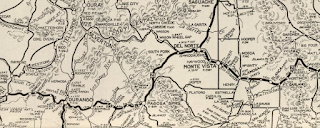
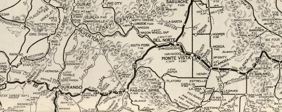
According to USends US Route 160 replaced much of US 450 west to the Utah State Line in 1934 and subsequently was routed over Wolf Creek Pass.  US 160 can be seen routed over Wolf Creek Pass on the 1939 Rand McNally Highway Map of Colorado.


US 160 has remained the highway over routed Wolf Creek Pass since 1934.  Wolf Creek Pass entered the lexicon of popular culture by way of C.W. McCall's 1975 Album and 1974 Song both titled "Wolf Creek Pass."   The lyrics of Wolf Creek Pass are as follows:

"Me an' Earl was haulin' chickens on a flatbed out of Wiggins, and we'd spent all night on the uphill side of thirty-seven miles of hell called Wolf Creek Pass. Which is up on the Great Divide?
We was settin' there suckin' toothpicks, drinkin' Nehi and onion soup mix, and I said, "Earl, let's mail a card to Mother then send them chickens on down the other side. Yeah, let's give 'em a ride."
[Chorus:]
Wolf Creek Pass, way up on the Great Divide
Truckin' on down the other side
Well, Earl put down his bottle, mashed his foot down on the throttle, and then a couple'a boobs with a thousand cubes in a nineteen-forty-eight Peterbilt screamed to life. We woke up the chickens.
Well, we roared up offa that shoulder sprayin' pine cones, rocks, and boulders, and put four hundred head of them Rhode Island reds and a couple a' burnt-out roosters on the line. Look out below; 'cause here we go!
Well, we commenced to truckin' and them hens commenced to cluckin' and then Earl took out a match and scratched his pants and lit up the unused half of a dollar cigar and took a puff. Says "My, ain't this purdy up here."
I says, "Earl, this hill can spill us. You better slow down or you gonna kill us. Just make one mistake and it's the Pearly Gates for them eight-five crates a' USDA-approved cluckers. You wanna hit second?"
[Chorus:]
Wolf Creek Pass, way up on the Great Divide
Truckin' on down the other side
Well, Earl grabbed on the shifter and he stabbed her into fifth gear and then the chromium-plated, fully-illuminated genuine accessory shift knob come right off in his hand. I says, "You wanna screw that thing back on, Earl?"
He was tryin' to thread it on there when the fire fell off a' his cigar and dropped on down, sorta rolled around, and then lit in the cuff of Earl's pants and burned a hole in his sock. Yeah, sorta set him right on fire.
I looked on outta the window and I started countin' phone poles, goin' by at the rate of four to the seventh power. Well I put two and two together, and added twelve and carried five; come up with twenty-two thousand telephone poles an hour.
I looked at Earl and his eyes was wide, his lip was curled, and his leg was fried. And his hand was froze to the wheel like a tongue to a sled in the middle of a blizzard. I says, "Earl, I'm not the type to complain; but the time has come for me to explain that if you don't apply some brake real soon, they're gonna have to pick us up with a stick and a spoon."
Well, Earl rared back, and cocked his leg, stepped as down as hard as he could on the brake, and the pedal went clear to the floor and stayed there, right there on the floor. He said it was sorta like steppin' on a plum.
Well, from there on down it just wasn't real purdy: it was hairpin county and switchback city. One of 'em looked like a can full'a worms; another one looked like malaria germs. Right in the middle of the whole damn show was a real nice tunnel, now wouldn't you know?
Sign says clearance to the twelve-foot line, but the chickens was stacked to thirteen-nine. Well we shot that tunnel at a hundred-and-ten, like gas through a funnel and eggs through a hen, and we took that top row of chickens off slicker than scum off a Lousiana swamp. Went down and around and around and down 'til we run outta ground at the edge of town. Bashed into the side of the feed store... In downtown Pagosa Springs.
[Chorus:]
Wolf Creek Pass, way up on the Great Divide
Truckin' on down the other side
Wolf Creek Pass, way up on the Great Divide
Truckin' on down the other side"

The lyrics describe the grades of Wolf Creek Pass which can be be infamously difficult in the winter months of Colorado.  US 160 over Wolf Creek Pass in recent decades has largely been expanded on both sides with climbing lanes including a new tunnel as of 2005.  Nonetheless the maximum grade of US 160 on both sides of Wolf Creek Pass is still a steep 6.8%.

These photos were taken on my eastbound ascent on US 160 up Wolf Creek Pass from the Wolf Creek Pass Overlook.  Amusingly the Wolf Creek Pass Overlook is located on the most severe hairpin curve on the ascent to Wolf Creek Pass.  


After crossing Wolf Creek Pass I continued east on US Route 160 to CO 150 in Alamosa County.  My next destination was north on CO 150 at Great Sand Dunes National Park & Preserve. 

Comments

Great post! Looking forward to reading your other Colorado roadtrip post.

Mike Macey
http://ColoradoMuseums.CO

Popular posts from this blog

I-40 rockslide uncovers old debates on highway

The Asheville Citizen-Times continues to do a great job covering all the angles of the Interstate 40 Haywood County rock slide. An article in Sunday's edition provides a strong historical perspective on how the Pigeon River routing of Interstate 40 came about. And perhaps most strikingly, in an article that ran just prior to the highway's opening in the fall of 1968, how engineers from both Tennessee and North Carolina warned "...that slides would probably be a major problem along the route for many years." On February 12, 1969, not long after the Interstate opened, the first rock slide that would close I-40 occurred. Like many other Interstates within North Carolina, Interstate 40 through the mountains has a history prior to formation of the Interstate Highway System and was also a heated political battle between local communities. The discussion for a road that would eventually become Interstate 40 dates back to the 1940's as the idea for interregional high

Mines Road

Mines Road is an approximately twenty-eight-mile highway located in the rural parts of the Diablo Range east of the San Francisco Bay Area.  Mines Road begins in San Antonio Valley in Santa Clara County and terminates at Tesla Road near Livermore of Alameda County.  The highway essentially is a modern overlay of the 1840s Mexican haul trail up Arroyo Mocho known as La Vereda del Monte.  The modern corridor of Mines Road took shape in the early twentieth century following development of San Antonio Valley amid a magnesite mining boom.  Part 1; the history of Mines Road Modern Mines Road partially overlays the historic corridor used by La Vereda del Monte (Mountain Trail).  La Vereda del Monte was part of a remote overland route through the Diablo Range primarily used to drive cattle from Alta California to Sonora.  The trail was most heavily used during the latter days of Alta California during the 1840s. La Vereda del Monte originated at Point of Timber between modern day Byron and Bre

Former California State Route 41 past Bates Station

When California State Route 41 was commissioned during August 1934 it was aligned along the then existing Fresno-Yosemite Road north of the San Joaquin River.  Within the Sierra Nevada foothills of Madera County, the original highway alignment ran past Bates Station via what is now Madera County Road 209, part of eastern Road 406 and Road 207.   Bates Station was a stage station plotted during the early 1880s at what was the intersection of the Coarsegold Road and Stockton-Los Angeles Road.   The modern alignment bypassing Bates Station to the east would be reopened to traffic during late 1939.   Part 1; the history of California State Route 41 past Bates Station Bates Station was featured as one of the many 1875-1899 Madera County era towns in the May 21, 1968, Madera Tribune .  Post Office Service at Bates Station is noted to have been established on November 23, 1883 and ran continuously until October 31, 1903.  The postal name was sourced from Bates Station owner/operator George Ba