
Replica highway signs at Disney

When you are in Disney on our honeymoon, you wouldn't expect to notice roadgeek items.  But at both Hollywood Studios and Animal Kingdom. Some very oddly placed highway sign replicas and creations can be found.


Like this I-95 New York Shield

I-95 New York...in Orlando?

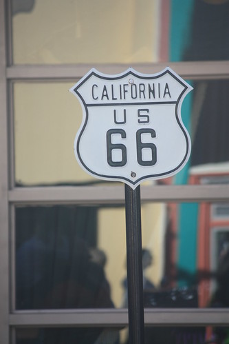
Or this US 66 California Shield

IMG_7890

Or ones that have no relation at all like this one in Animal Kingdom.

US 498 is located in Diggs County

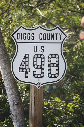
I'll let the sign experts decide how good of a replica and creation in the case of Diggs County 498 are.

Comments

Steve A said…
A for effort, definitely. Correct shapes and fonts are all I could ask for. Good eye!
US 71 said…
I want that traffic signal ;)

Shapes are almost dead-on, but I think the 66 is narrower that it should be. Otherwise, the other fonts look about right. Definitely points for effort!
Alice H. said…
I'm actually kinda surprised at how accurate these are. Nice!
Doug said…
Regarding the I-95 shield, the signal that it's next to is a type that was used in New York City years ago, well before Interstates existed.

Popular posts from this blog

US Route 62 and US Route 180 in the Guadalupe Mountains

US Route 62/US Route 180 between El Paso, Texas and Carlsbad, New Mexico passes through the Guadalupe Mountains.  The Guadalupe Mountains comprise the highest peaks of Texas which are largely protected as part Guadalupe Mountains National Park.  The automotive highway through the Guadalupe Mountains was constructed in the late 1920s as part of Texas State Road 54.  US Route 62 was extended from Carlsbad through the Guadalupe Mountains to El Paso during 1932.  US Route 62 was joined in the Guadalupe Mountains by US Route 180 in 1943.  The Guadalupe Mountains comprise a portion of the 130 mile "No Services" zone on US Route 62/US Route 180 between El Paso-Carlsbad. Part 1; the history of US Route 62 and US Route 180 in the Guadalupe Mountains The Guadalupe Mountains lie within the states of Texas and New Mexico.  The Guadalupe Mountains essentially is a southern extension of the larger Rocky Mountains.  The Guadalupe Mountains is the highest range in Texas with the peak elevati

Paper Highways; unbuilt California State Route 100 in Santa Cruz

This edition of Paper Highways examines the unbuilt California State Route 100 in Santa Cruz. The History of Unbuilt California State Route 100 The route that became CA 100 was added to the State Inventory in 1959 as part of the Freeway & Expressway System as Legislative Route 287 .  According to CAhighways.org the initial definition of LRN 287 had it begin at LRN 5 (CA 17) and was defined over the below alignment to LRN 56 (CA 1) through downtown Santa Cruz. -  Ocean Street -  2nd Street -  Chestnut Street For context the above alignment would required tearing down a large part of the densely populated Santa Cruz.  A modern Google imagine immediately reveals how crazy an alignment following Ocean Street, 2nd Street, and Chestnut Street would have been. LRN 287 first appears on the 1960 Division of Highways State Map . In 1961 the definition of LRN 287 was generalized to; from LRN 5 via the beach area in Santa Cruz to LRN 56 west of the San Lorenzo River. 

New Mexico State Road 7 (Carlsbad Caverns Highway)

New Mexico State Road 7 is approximately a seven-mile highway in the Guadalupe Mountains of Eddy County. New Mexico State Road 7 connects US Route 62/US Route 180 at Whites City to the visitor center of Carlsbad Caverns National Park via Walnut Canyon. The so-called Carlsbad Caverns Highway to the National Park visitor center complex was constructed following the designation of the namesake National Monument in 1923. The current iteration of New Mexico State Road 7 was designated by the New Mexico State Highway Commission during June 1929. A proposal once was once floated to connect New Mexico State Road 7 to a cavern drive which would have been blasted into Big Room. Part 1; the history of New Mexico State Road 7 What are now Carlsbad Caverns was explored in the Guadalupe Mountains of Eddy County by local Jim White during 1898.  White explored the caverns via a homemade ladder and named several of the more notable rooms.  The name "Carlsbad Caverns" was derived from the