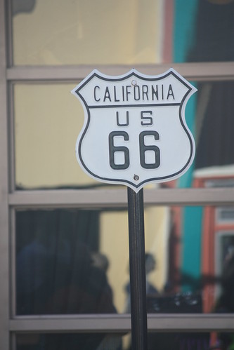
Replica highway signs at Disney

When you are in Disney on our honeymoon, you wouldn't expect to notice roadgeek items.  But at both Hollywood Studios and Animal Kingdom. Some very oddly placed highway sign replicas and creations can be found.


Like this I-95 New York Shield

I-95 New York...in Orlando?

Or this US 66 California Shield

IMG_7890

Or ones that have no relation at all like this one in Animal Kingdom.
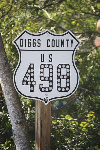
US 498 is located in Diggs County

I'll let the sign experts decide how good of a replica and creation in the case of Diggs County 498 are.

Comments

Steve A said…
A for effort, definitely. Correct shapes and fonts are all I could ask for. Good eye!
Anonymous said…
I want that traffic signal ;)

Shapes are almost dead-on, but I think the 66 is narrower that it should be. Otherwise, the other fonts look about right. Definitely points for effort!
Doug said…
Regarding the I-95 shield, the signal that it's next to is a type that was used in New York City years ago, well before Interstates existed.

Popular posts from this blog

Petroleum Club Road (former California State Route 33 and US Route 399 past the Lakeview Gusher)

Petroleum Club Road is an approximately 5.3-mile rural highway located in the Sunset Oil Field of western Kern County.  This corridor was constructed as a frontage road of the Sunset Railroad and would be the site of the Lakeview Gusher in 1910.  Petroleum Club Road was the original alignment of California State Route 33 and US Route 399 between 1934-1938.  In 1938 the West Side Highway was constructed west of Lakeview Gusher and still serves as the current alignment of California State Route 33.   Part 1; the history of Petroleum Club Road Petroleum Club Road is the original highway which linked the oil communities of Maricopa and Taft.  Both cities were developed around the early boom of the Sunset Oil Field.  The early Sunset Oil Field can be seen centered along Cienega Canyon Road southwest of Buena Vista Lake in Township 11 North, Range 23 West on the 1898 Kern County Surveyors map .  In 1901 Post Office Service would be established at the Su...

Kuakini Highway (former Hawaii Route 11 in Kailua-Kona)

Kuakini Highway east of Palani Road in Kailua-Kona is the original alignment of Hawaii Route 11.  The highway upon being commissioned in 1955 began at the Palani Road (then Hawaii Route 19) and followed Kuakini Highway southeast towards Holualoa.  Hawaii Route 11 was shifted to an extension of Queen Kaahumanu Highway during the late 1970s which bypassed downtown Kailua-Kona.   This page is part of the Gribblenation Hawaii Roads series.  A compellation of all Hawaii-related media from both Gribblenation and RoadwayWiz can be found by clicking  here .  Part 1; the history of Hawaii Route 11 and Kuakini Highway in Kailua-Kona Hawaii Route 11 is part of Mamalahoa Highway (the Hawaii Belt Road) and is the longest Hawaiian State Route at 121.97 miles.  The highway begins at the mutual junction of Hawaii Route 19 and Hawaii Route 190 in Kailua-Kona.  From Kailua-Kona the routing of Hawaii Route 11 crosses the volcanic landscapes of southern side of ...

Did Caltrans just kill the G26 cutout US Route shields?

The US Route System was formally created by the American Association of State Highway Officials during November 1926.  Through the history of the system the only state to which has elected to maintain cutout US Route shields has been California.  The G26 series cutout US Route shields have become a favorite in the road enthusiast hobby and are generally considered to be much more visually pleasing than the standard Federal Highway Administration variant.  However, the G26 shield series appears to have been killed off on January 18, 2026, when Caltrans updated their Manual of Uniform Traffic Control Devices.  This blog will examine the history of the US Route shield specifications in California and what is happening with the 2026 changes.  The blog cover photo is facing towards the terminus of California State Route 136 and at a G26-2 specification US Route 395 shield.  In the background Mount Whitney can be seen in the Sierra Nevada range.   ...