
Zehnder's Holzbrücke (Zehnder's Wooden Bridge)


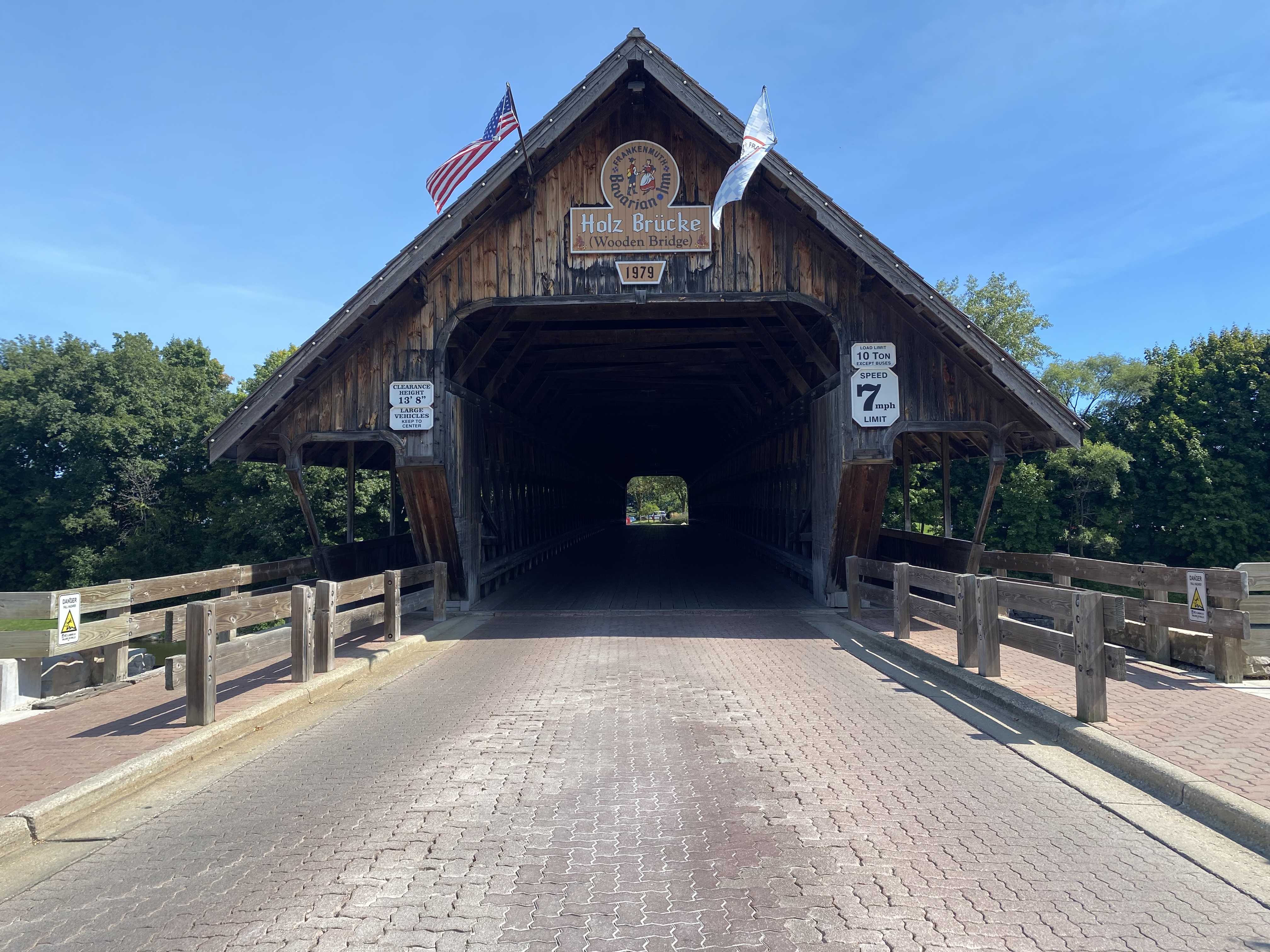
Zehnder's Holzbrücke (German for Wooden Bridge) is a covered bridge located on the Cass River on Covered Bridge Lane in the city of Frankenmuth, Michigan.  This structure was completed in 1979 and hauled into place by a team of oxen during 1980.  Unlike many modern covered bridges, the structure is not a facade and is constructed fully of wooden materials.  The span was installed promote tourism in Frankenmuth and provide access to the lands own by the Bavarian Inn south of the Cass River. 


Part 1; the history of Zehnder's Holzbrücke

Zehnder's Holzbrücke (German for wooden bridge) is a structure located on Covered Bridge Lane along the Cass River in the city of Frankenmuth River.  The structure is currently part of the Bavarian Inn complex.  Eddie (the Zehnder's of Frankenmuth family) and William Zehnder (Bavarian Inn family) originally began to explore the prospects of installing a covered bridge in 1962.  Both brothers owned portions of land along the eastern half of the Cass River.  The purpose of a new bridge was to serve as a tourist attraction and expand the parking capacity for the Bavarian Inn south of the Cass River.  

By 1979 the Zehnder brothers hired Milton Grade which was one of the last construction firms which specialized in building authentic covered bridges.  The 239-foot-long structure was completed during 1979 but had to installed at the Cass River.  Beginning during 1980 a team of oxen was used to pull the structure into place on the Cass River.  The bridge was dedicated on September 9, 1980. 

In 1985 the first phase of the Bavarian Inn Lodge complex completed east of the Cass River.  Much of the attractions south of the river were either built or purchased by Eddie Zehnder's family during the remaining balance of the 1980s.  During 2015 ownership of Zehnder's Holzbrücke was transferred to Frankenmuth Bavarian Inn Incorporated.  


Part 2; visiting Zehnder's Holzbrücke

Zehnder's Holzbrücke is located immediately east of M-83 in Frankenmuth along Covered Bridge Lane.  The structure is located next to the Covered Bridge Shop west of the Cass River.  


Zehnder's Holzbrücke facing east over the Cass River from a stylized pedestrian bridge.  


Zehnder's Holzbrücke facing northeast from the Bavarian Belle Riverboat


Zehnder's Holzbrücke facing was along Covered Bridge Lane.  The structure is rated for 10 tons and has an overhead clearance of 13'8 feet.  


Facing northeast on the Cass River from one of the pedestrian walkways on the bridge.  


Comments

Popular posts from this blog

2018 Mojave Road Trip Part 2; The deadly desert highway (California State Route 127 and Nevada State Route 373)

After leaving Barstow via Old Highway 58 my next destination was in Death Valley.  To access Death Valley from rural San Bernardino County required a trek on north on Interstate 15 to California State Route 127 which becomes Nevada State Route 373 at the state line. Along I-15 I encountered the road sign oddity that is Zzyzx Road about eight miles south of Baker.   Zzyzx Road is a four mile road that used to go to the Zzyzx Mineral Springs and Health Spa.   The spa was founded in the 1940s and the owner made up the name "Zzyzx" to claim it was the last word in the English Language.  The spa has been shut down since the 1970s and is now part of a Desert Studies Center for California State University. The southern terminus of CA 127 in Baker is located at I-15 exit 246.  CA 127 is a 91 mile north/south highway which runs to the Nevada State Line in Inyo County.  CA 127 is called Death Valley Road from I-15 northward.  South of CA 127 ...

New Idria Road to the New Idria ghost town

New Idria Road is an approximately 21.5-mile rural highway located in the Diablo Range of San Benito County.  From Panoche Road to approximately 20.6 miles to the south the corridor is maintained as the paved San Benito County Road 107.  The remaining 0.9 miles to the New Idria ghost town are no longer maintained and have eroded into a high clearance dirt roadway.  Upon reaching New Idria the roadway continues south as Clear Creek Road which passes through the Bureau of Land Management owned Clear Creek Management Area.   The New Idria Mercury Mine claim was staked in 1854.  Following the theme set by New Almaden the community and mine of New Idria were named after the famous Slovenian mercury mining town of Idrija.  Following a slow start the mines of New Idria would boom and the community would reach a peak population of approximately 4,000 by 1880.  New Idria Road and Panoche Road were constructed to facilitate stage travel to San Juan Bautista...

A Day in New York: The Biggest Road Map Ever!

The NY State Pavilion 22nd April 2014 was the 50th Anniversary of the opening of the 1964-65 World's Fair in what's now known as Flushing Meadows Corona Park. There has been an active effort to restore the New York State Pavilion . It's an iconic structure, and has the potential to be a great attraction. I'm not just talking out of my hat here: Today's viewing event drew thousands. One of the organisers said they expected like 800 people to show up. My DP and I went-and we got there early- the event started at 11.00am, and we got there at 10, and the line was incredible even then:  we waited on line to get a number for two hours and another hour and a half to get our number called. We left the park at 3.00 pm, and one of my friends from a band said he had gotten his number, and was waiting to get in and wondered if we were still about. This was at 4 pm. One of the features of the Pavilion is that the floor is a giant NY State roadmap by Rand McNally, and ...