
M-5 is a 27.890-mile-long State Trunkline located in Metro Detroit and largely consists of former segments of US Route 16. The highway was commissioned during 1977 between M-102 at Eight Mile Road east to Interstate 96 Exit 185 in Detroit. The highway expanded west rapidly from 1994 to 2002 during the construction of the Haggerty Connector to Pontiac Trail in Commerce Charter Township. During 2016 the corridor was extended east to Cass Avenue in Detroit over what had been the previously hidden Old Business Spur Interstate 96 along Grand River Avenue.

Part 1; the history of M-5
The general corridor of Grand River Avenue originated as a Native American footpath across what is now the Lower Peninsula of Michigan. The highway name is a reference to the Grand River which spans Somerset Township and empties into Lake Michigan near Grand Haven.
Upon the arrival of European settlers, the trail was widened into a functional roadway. The Grand River Road during the early 1850s were improved with a planked surface between Detroit-Lansing by the Detroit & Howell Plank Road Company and Howell & Lansing Plank Road Company. Both plank road companies operated their section of Grand River Road as a toll franchise which had gates placed in intervals of approximately five miles.
The toll franchises along the Grand River Road eventually folded following the emergence of railroads in Michigan. The corridor between Detroit and Lansing was designated as a State Trunkline during 1909. During July 1919 the State Trunkline following Grand River Avenue between Detroit and Lansing was assigned as part of M-16. M-16 extended further west to Muskegon following other established State Trunklines.
M-16 can be seen following Grand River Avenue between Detroit and Lansing on the 1920 George F. Cram map of Michigan.


During the Auto Trail era Grand River Avenue also had a corridor designation. The corridor can be seen as part of the Grand River Road Auto Trail on the 1924 Rand McNally map of Michigan. The Grand River Road is shown to have a white, orange and white trail marker.


The US Route System was formally designated by the American Association of State Highway Officials (AASHO) on November 11, 1926. The System was intended to designate an interstate system of connecting highways which was based in a grid. Coincidentally the already existing M-16 laid where US Route 16 would fit into said grid and the corridor was thusly designated as such.
US Route 16 can be seen spanning the Lower Peninsula of Michigan from Detroit west to the car ferry terminal in Muskegon on the 1927 Rand McNally Junior map of Michigan. The corridor is shown following Grand River Avenue from Detroit west to Lansing.


The city insert on the same map suggests that US Route 16 followed Grand River Avenue all the way into downtown Detroit and terminated at Woodward Avenue (US Route 10).

Eastbound US Route 16 can be seen ending at Woodward Avenue on the 1940 United States Geological Survey map of Detroit.

The 1947 United States Geological Survey map of Detroit shows a shift in the eastern terminus of US Route 16. The highway is shown following Grand River Avenue into downtown Detroit and turning south via Washington Boulevard to a new terminus at Michigan Avenue (US Route 112).

According to usends.com, the eastern terminus change in US Route 16 likely came in 1943. The highway was multiplexed beginning at Plymouth Road into downtown Detroit with US Route 12. Previously US Route 12 had ended at US Route 16 at the intersection of Grand River Avenue and Plymouth Road.
The westbound beginning of US Routes 16 and 12 can be seen at the corner of Michigan Avenue/Washington Boulevard in an undated photo (courtesy usends.com).

The mutual eastern terminus of US Routes 16 and 12 at Michigan Avenue/Washington Boulevard can be seen on the 1952 United States Geological Survey map of Detroit.

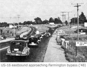
During 1947 a Michigan State Highway Department planning map depicted much of US Route 16 being considered for freeway relocation. A two-lane bypass of Grand River Avenue in Farmington was open to traffic by 1948 (photo courtesy of michiganhighways.org).
The Farmington Bypass can be seen as US Route 16 Bypass and Grand River Cutoff on the 1952 United States Geological Survey maps of Northville and Redford. The designation of "US Route 16 Bypass" never was officially sought by the Michigan State Highway Department. The initial bypass roughly corresponds to what is now Freedom Road.


The US Route 16 freeway corridor was initially planned to originate in Detroit largely following the alignment of Grand River Avenue westward towards Lansing. Much of these early freeway alignments would begin construction during the 1950s, in particular between Farmington west to Brighton. Much of these concepts would be annexed into Interstate Highway System as part of the 1956 Federal Aid Highway Act.
By 1958 the then recently completed Brighton-Farmington Expressway was incorporated into Interstate 96. During May 1959, the corridor of US Route 16 was shown to have been shifted to said freeway segment on a request by the Michigan State Highway Department to AASHO. The request (granted during June 1959) asked for the blessing of AASHO to relocate US Route 16 onto numerous complete segments of Interstate in the Lower Peninsula.


On May 12, 1961, the Michigan State Highway Department requested the elimination of US Route 112 and relocation of US Route 12 onto the vacated alignment. This request was granted by AASHO on June 28, 1961. At the time of the request much of US Route 12 had been relocated onto a multiplex of Interstate 94 from Ann Arbor east to Detroit.


On August 22, 1961, the Michigan State Highway Department would request US Route 16 be deleted in Michigan. AASHO considered and granted the request on October 7, 1961. The primary motivation for the deletion was due to the alignment of US Route 16 mostly being carried by new segments of Interstate freeway.


Following the deletion of US Route 16 in Michigan the corridor of Grand River Avenue east of Farmington into Detroit would become Business Spur Interstate 96. In 1964 the planned corridor of the Jefferies Freeway would be relocated from away from much of Grand River Avenue east of Farmington. The new corridor was selected along the Chesapeake & Ohio Railway and much of Schoolcraft Road.
When the Jefferies Freeway was completed in 1977 the corridor of Grand River Avenue from M-102 (Eight Mile Road) to Interstate 96 Exit 185 in Detroit was designated at M-5. M-102 was extended from the intersection Eight Mile Road and Grand River Avenue westward on the Brighton-Farmington Expressway to Interstate 275/Interstate 96. Following the designation of M-5 what was Business Spur Interstate 96 east of Interstate 96 Exit 185 was designated as the un-signed "Old Business Spur Interstate 96."
M-5 can be seen terminating at Eight Mile Road along with M-102 continuing west to Interstate 275/Interstate 96 on the 1985 United States Geological Survey map of Detroit.

The same map displays M-5 with an eastern terminus at Interstate 96 Exit 185 in Detroit.

During 1986 then Michigan Governor Jim Blanchard directed the Michigan Department of Transportation to develop a plan to ease traffic on the Interstate 696 corridor. Specifically, the agency was directed to draft plans for a new State Trunkline corridor in the vicinity of Haggerty Road. A proposed corridor (with numerous alternatives) was developed which would extend north from the Interstate 96/Interstate 275/Interstate 696 junction to the vicinity of Fifteen Mile Road. This extension was located in the never constructed northern corridor of Interstate 275 and was known on paper initially as M-275.
During 1989 corridor Alternative 4A was selected by the Michigan Department of Transportation. This segment of road (known as the Haggerty Connector) was constructed as an extension of M-5 which opened to Twelve Mile Road on October 27, 1994. The initial extension of M-5 subsumed what had been M-102 north of Eight Mile Road. On August 2, 1999, the Haggerty Connector was extended north to Fourteen Mile Road. The final extension north to Pontiac Trail was opened to traffic on November 1, 2002.
During April 2004 the eastern terminus of Old Interstate Business Spur 96 was transferred to the city of Detroit. The un-signed highway was truncated as existing on Grand River Avenue from Interstate 96 Exit 185 east to Cass Avenue.
The completed Haggerty Connector can be seen in detail on the 2011 United States Geological Survey map of Walled Lake.

During April 2016 the mileage belonging to Old Interstate Business Spur 96 was transferred as an extension of M-5. The highway was signed by the Michigan Department of Transportation to Cass Avenue. This extension brought the highway mileage up to 27.890 miles.
Part 2; a drive on M-5
Westbound M-5 begins at the junction of Grand River Avenue, Cass Avenue and Middle Street in Detroit (in Wayne County). This view facing north on Cass Avenue approaching Grand River Avenue.

Westbound M-5 follows Grand River Avenue out of downtown and over Interstate 75 (Fisher Freeway).


M-5 continues west and passes over M-10 (Lodge Freeway) near the Motor City Casino.


M-5 continues west along Grand River Avenue and passes over Interstate 94 (Edsel Ford Freeway).


West of Interstate 94 the routing of M-5 follows Grand River Avenue and crosses over Interstate 96 Exit 188.


M-5 west of Interstate 96 Exit 188 intersects the former alignment of US Route 12 at Plymouth Road.

M-5 west of Plymouth Road crosses over Interstate 96 Exit 185.

Westbound M-5 next crosses over M-39 (Southfield Freeway).


M-5 continues west on Grand River Avenue to US Route 24 at Telegraph Road.


M-5 westbound follows Grand River Avenue into Redford Charter Township. The highway continues through the community to Inkster Road where it briefly enters Livonia approaching M-102 at Eight Mile Road.


Westbound M-5 enters Farmington Hills of Oakland County. The highway follows Grand River Avenue and branches on the Farmington-Brighton Expressway at Purdue Avenue.


Westbound M-5 passes through Farmington Hills and Farmington where it reaches Grand River Avenue again at Exit 13.


M-5 continues as a freeway to the Interstate 96/Interstate 275/Interstate 696 interchange. North of the interchange the highway transitions to the Haggerty Connector. M-5 continues north as an expressway and terminates at Pontiac Trail in Commerce Charter Township.


Comments