

Located about 20 miles west of (or
about 30 miles upriver from) downtown New Orleans, the Bonnet Carré Control
Structure & Spillway is one of three large-scale flood control structures
on the lower Mississippi River designed to regulate the flow of water in the
river in the event of flooding. The other two structures, the Morganza Control
Structure and the Old River Control Structure, are located upriver from Baton
Rouge and were constructed in the 1950s and 60s, significantly later than the
construction that took place at this location in the early 1930s. The spillway here is designed so that the excess water that is diverted will flow directly into the southwestern reaches of Lake Pontchartrain and away from the populated areas of southeast Louisiana in the event of flood-stage river levels.
In the aftermath of the Great Mississippi Flood of 1927, the
United States government passed the Flood Control of 1928, which gave the U.S.
Army Corps of Engineers the authority to design, construct, and maintain a
flood protection system for the lower Mississippi River and allocated federal
funding for the large-scale undertaking. The levees along the river at New
Orleans are generally not designed to deal with unusually high river levels and
flow rates and the Bonnet Carré Spillway was conceived
as a way to relieve flood-stage water levels in the river and divert the excess
water safely away from the levees around New Orleans as part of the overall flood
protection plan for southeast Louisiana. This was the first large-scale control
structure and spillway project associated with this effort to modernize and rebuild
the levee system in the part of Louisiana in the aftermath of the Great Flood and
it was built shortly after this disaster, becoming operational in 1931.
Of the major spillways on the lower Mississippi River, this
is the one that gets utilized the most often. Since its completion, the Bonnet Carré Spillway has been opened 15 times, most recently
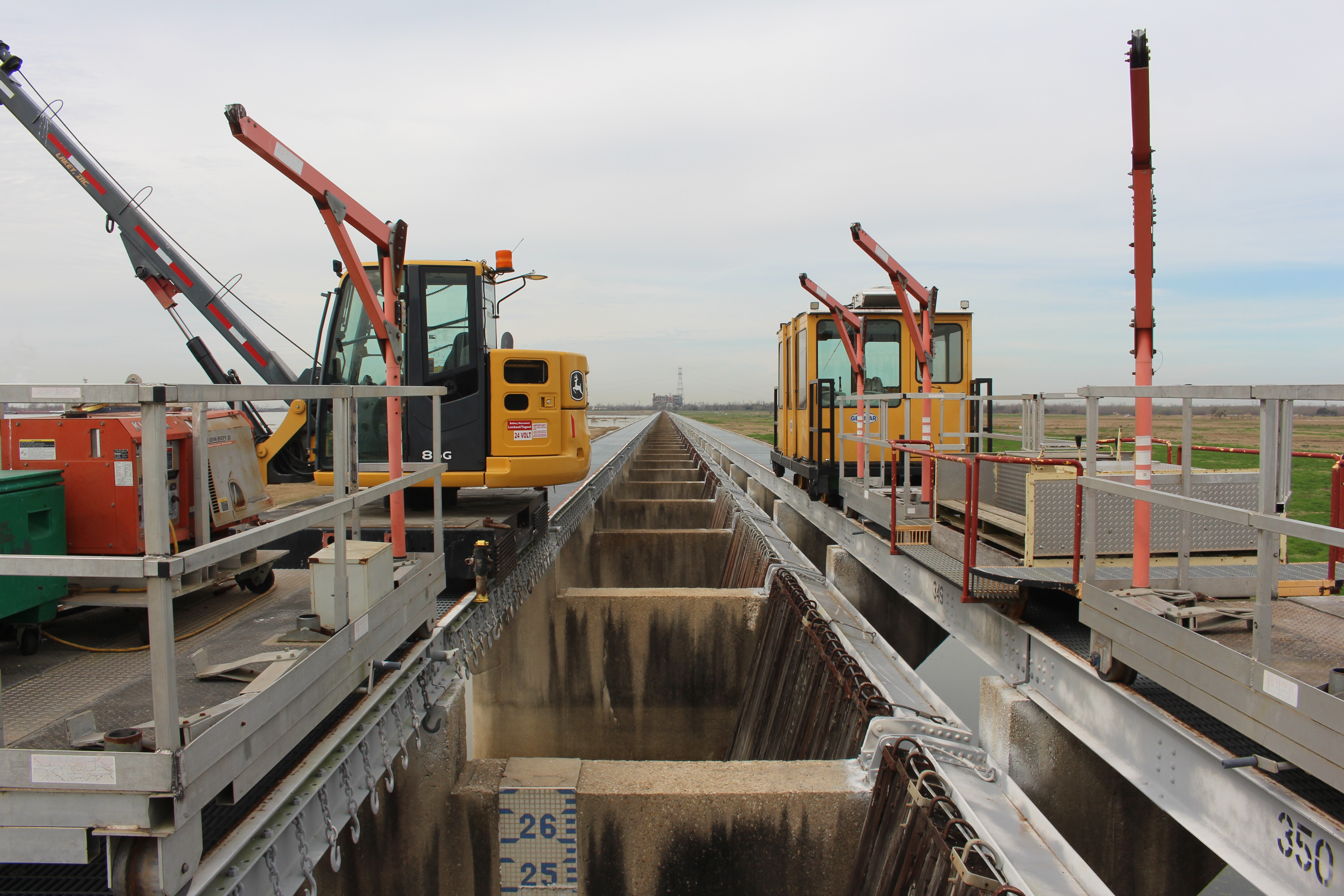
in 2020. The Control Structure itself is built of reinforced concrete
and is about 7,700 ft long and contains 350 individual bays that can be opened to
allow a maximum flow rate of 250,000 cubic feet per second. That volume is
roughly the equivalent of three Olympic-sized swimming pools for every second
that passes. Each of the control structure’s bays contain treated timber gates or
“needles” as they’re known, that can be lifted through the top of the structure
by rail-mounted gantry cranes to enable the passage of water into the spillway.
The total of 7,000 of these “needles” can be removed in as little as 36 hours,
however the spillway has not had to be opened to carry 100% of its maximum flow
rate since 1983. (By comparison, the spillway opening in 2020 opened 90 of the
structure’s 350 bays, resulting in a flow that was about 36% of its maximum
capacity.)
The spillway itself is about six miles long between the
Mississippi River inlet and the Lake Pontchartrain outlet. It varies in width
along its length, ranging from about 1 ½ miles wide near its inlet to about 2 ½
miles wide near its outlet. During times
when the spillway is not in use, the land contained within is used as a
recreation area open to the public. There are four bridges that span the
spillway – two of them are for road traffic and two of them are for railroad
traffic. US Highway 61 (Airline Highway) crosses the spillway closer to the
Mississippi River, while the Interstate 10 causeway bridge is located near the
spillway’s outlet on Lake Pontchartrain.
The following pictures from my visit to the Bonnet Carré Control Structure & Spillway in February 2024 showcase the views of the Mississippi River, the Control Structure, and the Spillway itself from the levee on the west side of the complex. Click on each photo to see a larger version.


The following pictures from my visit to the Bonnet Carré Control Structure & Spillway in February 2024 showcase the views of the Mississippi River, the Control Structure, and the Spillway itself from the levee on the east side of the complex. Click on each photo to see a larger version.


How To Get There:
Further Reading:
Bonnet Carre Spillway by John Weeks
Bridges, Crossings, and Structures of the Lower Mississippi River
Next Crossing upriver: Veterans Memorial Bridge (Gramercy, LA)
Next Crossing downriver: Hale Boggs Memorial Bridge (Luling, LA)
Return to the Bridges of the Lower Mississippi River Home Page
__________________________________________________
Comments