Civil War Road Trip Day 4 - Returning Home

Virginia is for Lovers at the Buchanan Swinging Bridge

The final day of the road trip saw us head back south and home to Charlotte.  However, we did make a few stops, specifically Natural Bridge State Park and the town of Buchanan, Virginia.

Route: I-81, US 11, I-81, US 11, I-581, US 220, I-73, NC 68, I-74, Business I-85, I-85, home.

For the full photo set on flickr - head here.


Traffic wasn't too bad on 81 and the scenery this Sunday morning was very pretty.
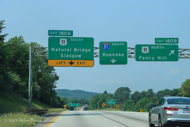
Getting to Natural Bridge State Park from I-81 South involves a unique left-hand exit.

US 11 was a common theme along I-81 - weaving in and around the Interstate - almost inviting you to take a trip back in time.  We exited off the Interstate twice to follow US 11 - to Natural Bridge State Park and then Buchanan.

Virginia's Natural Bridge State Park

Natural Bridge is a beautiful site that demonstrates the power and wonder of nature.  Privately owned until transferred to the Virginia State Park System in 2016, Natural Bridge State Park features hiking trails, a small natural history museum, a living history exhibit showcasing the life of the Monacan Indians, caves, and waterfalls.  

Keep an eye out for name carvings within the rocks!

Admission to access the bridge is $9/per person over 13 and $6 for children between 3-12.  Admission can be paid either at the Natural Bridge Visitors Center or at the bottom of the gorge at a small ranger/concession stand.

Doug recently wrote a more in-depth feature on Natural Bridge State Park.  The park is a pleasant break from the traffic on Interstate 81, and you can easily spend an enjoyable 60 to 90 minutes here.

It's easy to get back onto the Interstate from Natural Bridge State Park.

After briefly returning to Interstate 81, we ventured onto US 11 again and into the Town of Buchanan.  Buchanan is home to a pedestrian swing bridge over the James River.  

Buchanan Swinging Bridge

The local landmark dates to 1938 after a new (and still-standing) concrete bridge carrying US 11 over the James River was completed.  The Buchanan mayor insisted that a pedestrian connection would continue over the river.  

The swinging bridge is one of several existing and former James River crossings at Buchanan since 1851, including three covered bridges and an iron bridge.

A unique combination of exit letters on Interstate 581 South.

We got back on the Interstate south of Buchanan. In Roanoke, we headed south on Interstate 581 and US 220 back into North Carolina.  Interstate 581 uses the old-style directional exit numbers using N, S, E, and W instead of A&B.  Though at Exit 3, there is a 3C, W, and E!

The trip with Colton was great! It was amazing to return to past trips with him.  There were some fun memories too.  We can't wait to go on our next father-son or full-family adventure!

Site Navigation:


Comments

Popular posts from this blog

Dillon Road

Dillon Road is a 34.2-mile highway located in northern Coachella Valley of Riverside County, California.  Dillon Road begins at Avenue 48 on the outskirts of Indio and ends to the west at California State Route 62 near San Gorgonio Pass.  Dillon Road was developed the 1930s as a construction road for the Colorado River Aqueduct.  Dillon Road serves as a northern bypass to much of the development of Coachella Valley.  Dillon Road is known for it's frequent dips and spectacular views of San Gorgonio Pass.   Part 1; the history of Dillon Road Dillon Road was constructed as a haul road for the Colorado River Aqueduct through Coachella Valley.  The Colorado River Aqueduct spans 242 miles from Parker Dam on the Colorado River west to Lake Mathews near Corona.  Construction of the Colorado River Aqueduct began during January 1933 near Thousand Palms and was made functional on January 7, 1939.  West of Berdoo Canyon Road the alignment of Dillon Road is largely concurrent with the Colorado

Tehachapi-Willow Springs Road

Tehachapi-Willow Springs Road is an approximately 21-mile highway located in southeast Kern County.  Tehachapi-Willow Springs Road begins at Tehachapi Boulevard (former US Route 466) in Tehachapi and crosses the Tehachapi Mountains via the 4,820-foot-high Oak Creek Pass.  Tehachapi-Willow Springs Road enters Antelope Valley of the wider Mojave Desert and passes by the historic stage station of Willow Springs to a southern terminus at Rosamond Boulevard.  Tehachapi-Willow Springs Road has historic ties to the Havilah-Los Angeles Road and Stockton-Los Angeles Road due to the once reliable presence of water at Willow Springs. Part 1; the history of Tehachapi-Willow Springs Road Oak Creek Pass and Willow Springs were known to the local tribes of the Tehachapi Mountains for generations.  The first documented European crossing of Oak Creek Pass was during 1776 as part of an expedition by Francisco Garces.  Oak Creek Pass is as used again by John C. Fremont during an 1844-1845 expedition to e

The 1928 Iowa Hill Road Bridge

The 1928 Iowa Hill Road Bridge is a derelict structure located in the Sierra Nevada Mountains of Placer County, California.  The 1928 Iowa Hill Road Bridge can be found between the communities of Colfax and Iowa Hill.  The 1928 Iowa Hill Road Bridge is a wire suspension structure which spans the North Fork American River.  The 1928 Iowa Hill Road Bridge was replaced by a modern span and converted to pedestrian use following floods during 1963.   Part 1; the history of the 1928 Iowa Hill Road Bridge During 1853 gold was discovered at what to become Iowa Hill.  The gold mining claims soon led to a small community known as Iowa City being established.   By 1854, Post Office Service began at the mines of Iowa City.  By 1856 gold production at Iowa City was estimated to be around $100,000.  Iowa City was burned in fires during 1857 and 1862 but the community was rebuilt with more modernized structures.   The location of Iowa City can be seen as "Iowa Hill" on the 1873 Bancroft