Quartzsite is located along Interstate 10 and US Route 95 in the Sonoran Desert of La Paz County, Arizona. Main Street in Quartzsite historically is tied to the corridors of US Route 60 and US Route 70. This blog will examine the history of highway designations in Quartzsite with special emphasis on placed on US Route 60 and US Route 70. US Route 60 and US Route 70 can be seen passing through Quartzsite on the 1942 United States Geological Survey map.
Part 1; the history of US Route 60 and US Route 70 in Quartzsite
The present town of Quartzsite lies near the historic location of
Tyson's Wells. Tyson's Wells was settled by Charles Tyson during 1856. Tyson built a small fortification around his water supply. Tyson's Wells would become a well-known watering hole for stages after mining claims were struck in the La Paz Mining District during 1862. Tyson's Wells would become one of the primary resupply points for stages traveling along the highways from the La Paz Mining District either east towards Prescott or west towards California and the Bradshaw Trail.
The importance of Tyson's Wells and the Ehrenburg-Prescott Highway would diminish once the La Paz Mining District began to decline during the late 1860s and the early 1870s. Tyson's Wells would eventually be abandoned as railroad service in Arizona Territory became regularized and bypassed the much of the corridor of the Ehrenburg-Prescott Highway. Tyson's Wells would see a revival during 1879 when new mining claims were struck. The revived community around Tyson's Wells would come to be known as "Quartzsite."
Overland transportation through Quartzsite began to reemerge during the early 20th century. The Ehrenburg-Prescott was renamed as the "Sunkist Highway." The Sunkist Highway from Wickenburg west to the Colorado River near Ehrenburg was added to the State Highway System by the Arizona State Highway Commission as part of the original Arizona State Route 74 on September 9, 1927. The original Arizona State Route 74 can be seen passing through Main Street in Quartzsite on the 1927 Arizona State Highway Commission Map.

The
February/March 1928 California Highways & Public Works featured the opening of the Colorado River Bridge (Blythe-Ehrenburg Bridge) at the Arizona state line east of Blythe. The Colorado River Bridge opened as a Riverside County owned tolled crossing which replaced the existing ferry to Ehrenburg. Arizona State Route 74 ended at the Colorado River Bridge as the structure was owned by Riverside County. Traffic crossing the Colorado River Bridge from Arizona State Route 74 could connect to Legislative Route Number 64 in California at the western end of city of Blythe.


As originally envisioned in the early drafts of US Route System what became US Route 66 in California was intended to be US Route 60. The designation of the Chicago-Los Angeles corridor was intended to carry a X0 route number given it was to denote a major east/west US Route. Ultimately the State of Kentucky petitioned to have a X0 US Route and the Chicago-Los Angeles corridor became US Route 66 in the finalized US Route System created by the American Association of State Highway Officials (AASHO) during November 1926.
US Route 60 would rapidly be extended after the US Route System was created and would come into play in California during the early 1930s. A letter from the AASHO Executive Secretary to the California State Highway Engineer dated Marth 30, 1931, noted US Route 60 had been tentatively approved to be extended to California during the AASHO Executive Committee on May 26, 1930. The approval of US Route 60 being extended to California carried the stipulation that the Colorado River Bridge in Blythe be purchased by the California Division of Highways and Arizona State Highway Commission. The letter noted California and Arizona had taken steps through their respective legislatures to purchase the Colorado River Bridge and the terminus of US Route 60 to be at an undisclosed location in Los Angeles.


A letter from the California State Highway Engineer to the AASHO Executive Secretary on April 13, 1931, noted legislation to purchase the Colorado River Bridge had been passed in California. The purchase of the Colorado River Bridge effectively made the extension of US Route 60 into California active. Legislative Route Number 64 was extended from Blythe to the Arizona state line by way of 1931 Legislative Chapter 82. Within Arizona, US Route 60 west of Wickenburg replaced the entirety of Arizona State Route 74.
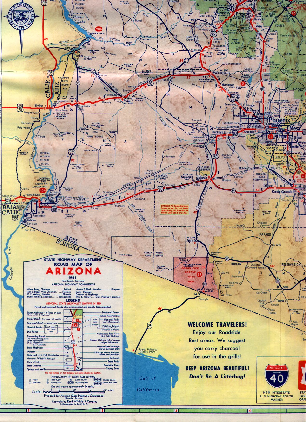
US Route 60 and Arizona State Route 74 can be seen running concurrently from Wickenburg west to the Colorado River Bridge on the
1933 Midwest Map Company Arizona Highway Map. Within Quartzsite the routing of US Route 60 replaced Arizona State Route 74 along Main Street.
A September 1934 exchange of letters between the California State Highway Engineer and AASHO acknowledged US Route 70 had been extended into California with an endpoint following US Route 60 into downtown Los Angeles. Within Arizona, US Route 70 would multiplex US Route 60 from Globe west to the California state line. Within Quartzsite, US Route 70 multiplexed US Route 60 on Main Street.
On
June 20, 1938, Arizona State Route 95 was extended from US Route 80 in Yuma to Arizona State Route 72 in Bouse. Arizona State Route 95 intersected US Route 60/US Route 70 via Central Boulevard and Quartzsite. North of Quartzsite the original routing of Arizona State Route 95 followed the Sunkist Trail towards Bouse.
On June 29, 1956, the Federal Highway Aid Act of 1956 was signed into law on the Federal Level. The Federal Highway Aid Act of 1956 was the genesis point of the Interstate Highway System which would in the coming see the corridor of US Route 60/US Route 70 west of Phoenix to the Colorado River replaced by Interstate 10.
US Route 95 was approved to be extended from Blythe to the Mexican border at San Luis, Arizona, by the AASHO Executive Committee on June 28, 1960. The extension of US Route 95 to the Mexican border was desired by the Arizona Highway Department and was not objected by the Division of Highways. US Route 95 from Intake Boulevard multiplexed US Route 60/US Route 70 and planned Interstate 10 along Hobsonway to the Colorado River and Arizona state line. From the California state line US Route 60/US Route 70/US Route 95 multiplexed east to Main Street in Quartzsite. US Route 95 branched south from US Route 60/US Route 70 via Central Boulevard over what had been the southern leg of Arizona State Route 95.

On June 24, 1969, AASHO approved an Arizona Highway Department request to truncate US Route 70 from the California State Line to Globe, Arizona. The truncation of US Route 70 removed it from the multiplex of US Route 95/US Route 60 and Interstate 10 between Blythe to Quartzsite, Arizona.
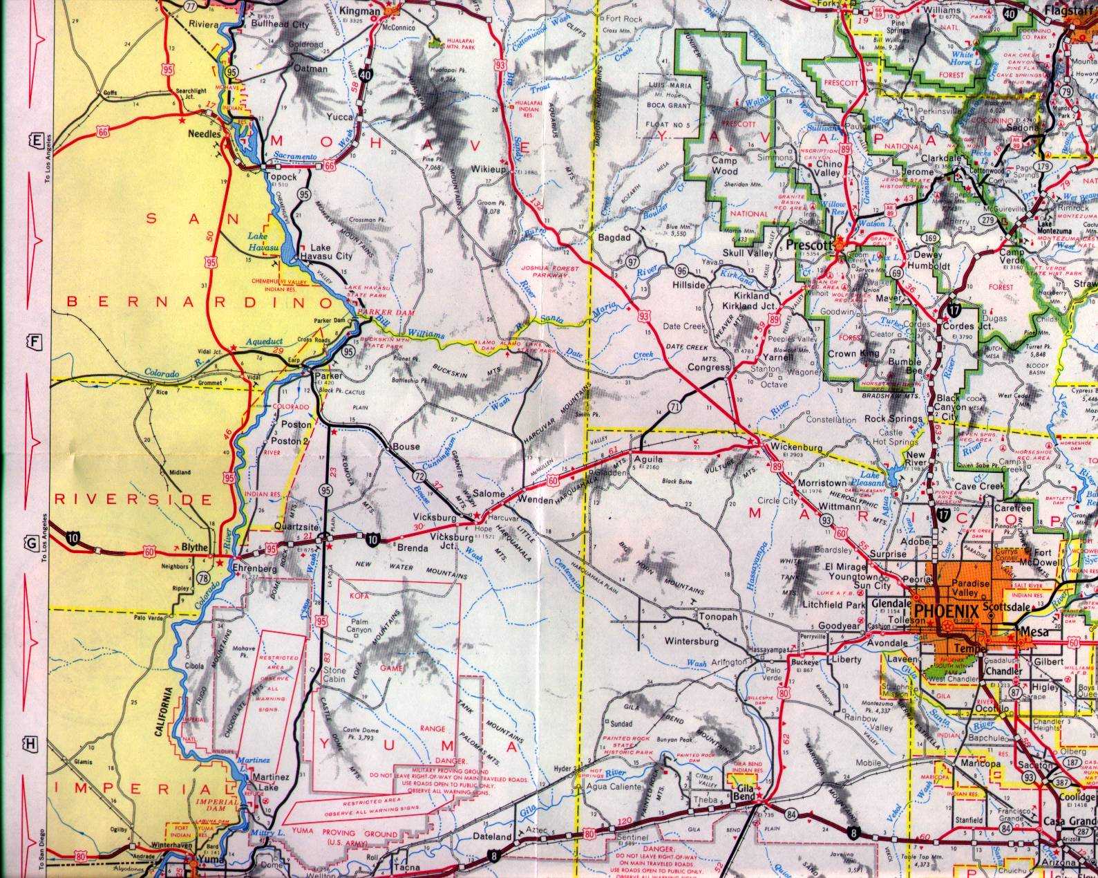
A March 1969 letter by the Arizona State Highway Commissioner regarding the application to truncate US Route 70 indicated that Interstate 10 had completed from the California state line east through Quartzsite towards vicinity of Brenda. US Route 60 effectively was moved to a multiplex of the new freeway alignment of Interstate 10 through Quartzsite. US Route 95 was left aligned on Main Street in Quartzsite west from Central Boulevard. It is unclear when the Interstate 10 Business Loop along Main Street in Quartzsite began to be signed as a formal request to AASHO was never made.


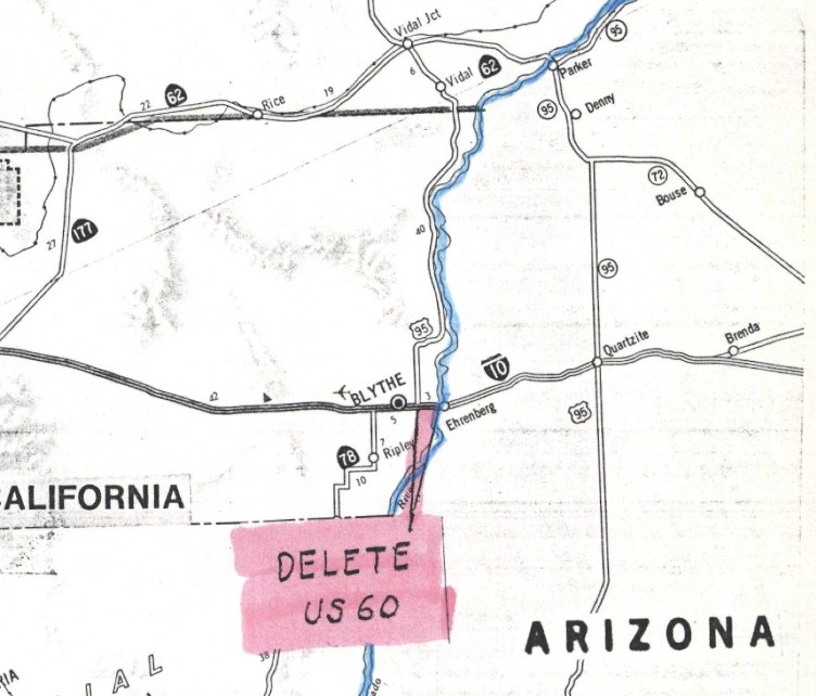
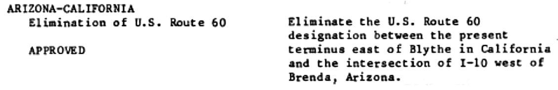
AASHTO (now the American Association of State Highway Transportation Officials) deferred a Caltrans request to truncate US Route 60 between US Route 95 in Blythe and the Arizona state line on June 29, 1982. The request to truncate US Route 60 from Blythe was deferred pending a like application from Arizona. Caltrans noted in their request that US Route 60 was not signed along US Route 95/Interstate 10 east of Blythe to the Arizona state line.
US Route 60 was officially deleted in California during their
November 1982 meeting. US Route 60 was truncated from US Route 95 in Blythe to Interstate 10 near Brenda, Arizona. The truncation of US Route 60 removed it from the multiplex of Interstate 10 in Quartzsite. The town of Quartzsite would formally incorporate less than a decade after the truncation of US Route 60 during 1989.
Part 2; a drive along former US Route 60 and US Route 70 on Main Street in Quartzsite
Former US Route 60/US Route 70 in Quartzsite can be accessed from westbound Interstate 10 Exit 19. The Interstate 10 Business Loop is shown originating from Exit 19 along Riggles Avenue and connecting north to Main Street. Signage indicates US Route 95 and Arizona State Route 95 can be accessed following the Interstate 10 Business Loop. East of Exit 19 the former routing of US Route 60/US Route 70 was what is now Dome Rock Road.
The Interstate 10 Business Loop follows Main Street westbound and intersects US Route 95/Arizona State Route 95 at Central Boulevard.
US Route 95 and the Interstate 10 Business Loop multiplex on Main Street west of Central Boulevard to Quartzsite Avenue. US Route 95 and the Interstate 10 Business Loop follow Quartzsite Avenue to the Interstate 10 entrance ramp where the latter terminates. US Route 95 begins multiplex west on Interstate 10 towards the Colorado River.


Comments