 |
| Union cannon near the site of Pickett's Charge |
Day Three saw Colton and I head north into South Central Pennsylvania and Gettysburg. It was the most enjoyable part of the trip, and we also saw a wide variety of things.
Route: I-81, I-70, MD 66, MD 77, US 15, PA 116, PA 16, US 11, PA 163, MD 63, US 11, I-81.
For the entire day's photo set on flickr - please head here.
There's a lot to do and see in Gettysburg. Compared to Antietam - it is more tourist-oriented, and the crowds can be overwhelming. On this pleasant May Saturday - Colton and I did not feel overwhelmed or rushed by tourists.
When I visited in October 2001 - you could schedule a guided tour, but I thought it was in advance. I recall how I should have done it that year and would the next time. I thought Colton would be good with a tour guide a few years from now; however, after a quick call to my wife and some begging from Colton, I changed my mind and said yes.
It was certainly worthwhile. Similar to Antietam, you can purchase a guided tour of the grounds. We were fortunate that there were guides readily available. We got to Gettysburg around 10 am - where we purchased our tickets and three-hour tour - our guide was ready at 10:15. Tours can be two or three hours, or if you wish to purchase longer. Guided tours purchased at the Visitors Center are offered by the Gettysburg Foundation. There are also options for bus and bicycle tours. We were fortunate to have an available guide - but purchasing your guided tour at least 24 hours in advance is recommended.
There are so many unique little details that we learned and picked up on this trip!
Like how to know if battlefield cannons are not replicas.
 |
| You can tell if a cannon is original - and not a replica - if the forge marks are at the end of the barrel. Also, you can see the rifling inside the cannon. |
Or the local resident - a 69-year-old veteran of the War of 182 - that took arms in the battle.
 |
| The monument to John Burns - a 69-year-old Gettysburg resident - who joined Union forces on the first day of the battle. |
Or Sallie Ann Jarrett, the beloved mascot dog of the 11th Pennsylvania Infantry.
We took in the usual sights, but with the help of our guide, we went into more detail and had plenty of questions answered.
 |
| Our guide, John, with my son Colton talking about cannons and how they were used in the war. |
 |
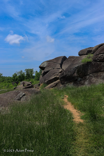
| Devil's Den |
 |
| Little Round Top |
There is so much at Gettysburg - it can be a multiple-day visit. We would have needed more time to venture into town, check out a museum or two, or do a ghost tour. Plus, there is so much detail that you can immerse yourself into throughout the battlefield that a return visit (not 22 years apart) is in order.
After lunch at the visitor's center and taking in the film and cyclorama, Colton and I hit our second National Park Service facility of the day - Eisenhower National Historic Site. Located just south of Gettysburg on Business 15, this is the historic farmstead and home of former President Dwight D. Eisenhower.
 |
| Eisenhower Homestead |
Eisenhower purchased the farm in 1950. He would often host foreign dignitaries at the farm during his presidency. He was also known to give his visitors personalized tours of the Gettysburg Battlefield.
While we got to the farm too late to tour the home - we were able to tour the outside grounds. It was also personally the highlight of the trip when Colton helped a park ranger take down the American flag at the end of the day.
Our trip didn't stop there as nearby sits the Sachs Covered Bridge. Built in 1852, Confederate and Union troops utilized the March Creek crossing before, during, and after the battle. The then-Pennsylvania Department of Highways called the bridge "Pennsylvania's Most Historic" in 1938.
 |
| Sachs Covered Bridge |
The bridge is also a popular spot for paranormal enthusiasts and investigators. The bridge is considered haunted with numerous ghost stories.
 |
| John Eisenhower Bridge |
Also nearby is the John Eisenhower Bridge. An iron truss bridge built in 1886, it is named after President Eisenhower's son, John. The bridge is closed to vehicular traffic and was nearly destroyed after a flood in 1996.
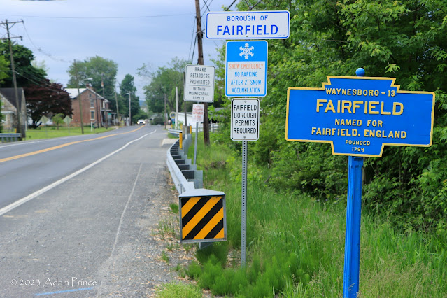
It was then time to head back to our hotel in West Virginia, but not before we found a few Keystone Town Markers to take photos of.
And another covered bridge - Jacks Mountain Covered Bridge.
 |
| Jack's Mountain Covered Bridge - officially known as the G. Donald McLaughlin Covered Bridge. |
Located just off PA 116 - it is the only covered bridge in Adams County vehicles can still drive. The short 75-foot-long bridge was built in 1890 and carries one lane of traffic over Tom's Creek.
We would hit a steady rain on our way back over the mountains towards Interstate 81. As a result, I missed getting a few more Keystone Town Markers. We crossed into Maryland on PA 163, and while it was nice to see an 'END' sign for PA 163 - the nearly 100-year-old concrete pylon marking the border was no longer standing.
Of course, the road highlight of the trip was finding the still-standing old-style JCT US 11 Maryland sign in Williamsport.
Day Three was very enjoyable - we did see and do a lot. Colton and I agreed that we needed to come back (maybe this fall) - I did promise him a ghost tour after all.
Site Navigation:


Comments