 |
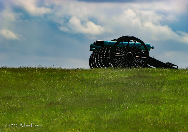
| Cannons at Antietam. |
The second day of our adventure had us continuing through the Shenandoah Valley into West Virginia and then over to Antietam and Harpers Ferry. It was my first visit to both locations in over twenty years, and I was looking forward to returning.
Route: US 11, I-81, WV 45, WV 480, MD 34, MD 65, MD 34, WV 480, WV 230, US 340, WV 51.
For a full set of photos from the second day of the trip head over here.
Interstate 81 had its moments on the drive north, but it wasn't too bad overall.
Our first stop would be at Antietam National Battlefield. When I first visited in October 2001, this was my favorite of the battlefields I visited that year (Manassas, Gettysburg, Antietam). So I was excited to go back and share the trip with Colton.
Currently, the Antietam Visitors Center is being rebuilt, and a temporary one is open across from it. After taking in the film - narrated by James Earl Jones - Colton and I began to do the self-guided auto tour of the battlefield. But not before Colton spent time with the rangers discussing ghosts and inspecting some of the munitions used in the battle.
 |
| My son, Colton, inspecting munitions from the Antietam Battlefield. |
Antietam is a special place - a hallowed ground - it is the bloodiest single-day battle in United States history. Over 23,000 men died, were wounded, or captured here. It is a beautiful area with rolling fields and open farmland.
 |
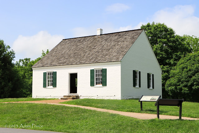
| Dunker Church - the first stop of the auto tour - and a key landmark in the morning of the battle. |
 |
| The Maryland monument pays tribute to Maryland soldiers that fought on both sides of the war at Antietam. |
The auto tour consists of 11 stops and follows the timeline of the battle. It took us a little over two and a half hours to complete. At many stops, there are short hiking trails that allow you to explore key areas of the battle, like the Cornfield, Sunken Road/Bloody Lane, and others.
 |
| The Clara Barton monument and Joseph Poffenberger Farm at the North Woods stop. You can access the site of the Cornfield battle along a hiking trail here. |
Another option is to hire a tour guide to ride with you via the Antietam Battlefield Guides group. Tours range from two to over six hours at various rates. The recommended tour is three hours at a cost of $120. The guide will ride or drive your vehicle through the battlefield (and surrounding areas) and can personalize the tour to your specific interests. Colton and I did not do this at Antietam; however, it is something we certainly will consider next time.
 |
| The 1896 War Department observation tower rises over Sunken Road or Bloody Lane. |
 |
| The Sunken Road was an old wagon shortcut between local turnpikes. The battle here would give it the nickname "Bloody Lane." |
 |
| The observation tower gives great views of the countryside. Antietam is a great place to take a quiet bike ride. |
 |
| South Mountains as views from the War Department observation tower. |
 |
| Looking back at Bloody Lane - it is amazing to think of the battle and the number of lives lost down this now-quiet land. |
There were many personal favorite sites along the drive, the nearly 130-year-old War Department observation tower at Sunken Road. If you don't mind steps - the views are amazing. And of course, Burnside's Bridge - the stone arch bridge over Antietam Creek.
 |
| Burnside's Bridge may be the most historic stone arch bridge in the country. Built in 1836, it is the site of one of the more famous engagements at Antietam. |
 |
| Looking up at the hillside that was held by Toombs' 2nd and 20th Georgian Divisions. |
We finished at Antietam National Cemetery before returning to the Visitor's Center for a ranger talk.
Antietam is quiet and solemn. It lacks the crowds of Gettysburg and is considered one of the best-preserved battlefields in the country. It is easy to close your eyes and imagine the battle that bloody September day.
From there, it was south to Harpers Ferry. We enjoyed the rolling drive of WV 230 with the air-time hills - Colton loves roller coasters, and it reminded him of the bunny/air-time hills at the end of many rides.
Harpers Ferry is a unique town. It is home to the Harpers Ferry National Historical Park, a long-standing railroad town, the Appalachian Trail, and where the Shenandoah River meets the Potomac.
 |
| Lower Town Harpers Ferry within Harpers Ferry National Historical Park. |
 |
| John Brown's Fort - the former Harpers Ferry Armory - was the site of his famous 1859 raid that he had hoped would initiate a slave uprising. After the Civil War, the building was once on display in Chicago, stood for over a decade at a nearby farm, located within Storer College's campus, before being moved to its current location in 1968. It sits about 150 feet east of its original location. |
There are a couple of options to get into the heart of Harpers Ferry. We took the most common option - park at the National Park Visitors Center off of US 340 - pay the fee - and then take the shuttle bus down into what is known as 'Lower Town.' You can drive into town and park (it is limited) or park at the local Visitor's Bureau (across the street from the NPS) and hike down.
Harpers Ferry is unique - it is a trip back in time and almost to another place. The historical area within Lower Town has numerous walk-through exhibits through old stores and homes. At the same time, there are places to eat and shop. The town is a mix of local residents, tourists, recreational visitors, and through-hikers on the Appalachian Trail.
 |
| The current 1894 railroad bridge and the remains of the Bollman Bridge at Harper Ferry. |
 |
| The ghost sign advertisement along the exposed rocks in Maryland Heights reads, "Mennen's Borated Toilet Talcum Powder." The sign dates to 1906. Efforts were made to conceal the sign in the 1960s; however, after a few years, the remains of the old sign reappeared. |
 |
| T-Shirts with the sign are available for sale at the NPS Bookstore at Gift Shop in Lower Town Harpers Ferry. |
Harpers Ferry was an important transportation center. The first railroad came through Harper's Ferry in 1836. During the Civil War, the rail crossing over the Potomac was destroyed and rebuilt several times. After the war, a new iron bridge - called the Bollman Bridge - was built. It would later convert to automobile use until it was destroyed by floodwaters in 1936. The remains of the bridge piers stand next to the 1894 bridge built as a replacement.
 |
| The famed white blazes for the Appalachian Trail are marked on a lamppost in Harpers Ferry. |
The current bridge also has an added pedestrian walkway that carries the Appalachian Trail over the Potomac. Colton and I met a through-hiker at the bridge and talked to him briefly.
Harpers Ferry was more enjoyable than expected. I even got an "I'm glad we stopped, Dad" from Colton. He initially didn't want to go to Harpers Ferry but in the end, really enjoyed it. It wouldn't be the first "I'm glad we did stop" I'd get on this trip.
Site Navigation:


Comments