California State Route 212 was a briefly lived post-1964 State Highway Renumbering designation assigned to Valley Boulevard in the Los Angeles metropolitan area. California State Route 212 was defined as beginning at the east city limit of Los Angeles at the location of the planned Long Beach Freeway and followed Valley Boulevard to Interstate 10 in El Monte. The origin of California State Route 212 in the State Highway System was part of the interim components used by US Routes 60-70-99 as Ramona Boulevard was being constructed. The blog cover image is of the 1964 Division of Highways Map which depicted the alignment of California State Route 212.
The history of California State Route 212
The origins of what would become California State Route 212 (CA 212) can be traced to the extension of US Route 60 into California. As originally envisioned in the early drafts of US Route System what became US Route 66 in California was intended to be US Route 60. The designation of the Chicago-Los Angeles corridor was intended to carry a X0 route number given it was to denote a major east/west US Route. Ultimately the State of Kentucky petitioned to have a X0 US Route and the Chicago-Los Angeles corridor became US Route 66 in the finalized US Route System created by the American Association of State Highway Officials (AASHO) during November 1926.
US Route 60 (US 60) would rapidly be extended after the US Route System was created and would come into play in California during the early 1930s. A letter from the AASHO Executive Secretary to the California State Highway Engineer dated Marth 30th, 1931 noted that US 60 had been tentatively approved to be extended to California during the AASHO Executive Committee on May 26th, 1930. The approval of US 60 being extended to California carried the stipulation that the Colorado River Bridge in Blythe be purchased by the California Division of Highways and Arizona State Road Department. The letter noted California and Arizona had taken steps through their respective legislatures to purchase the Colorado River Bridge and the terminus of US 60 to be at an undisclosed location in Los Angeles.


A letter from the California State Highway Engineer to the AASHO Executive Secretary on April 13th, 1931, noted legislation to purchase the Colorado River Bridge had been passed in California. The purchase of the Colorado River Bridge effectively made the extension of US 60 into California active.
The California State Highway Engineer submitted a recommended routing of US 60 to the AASHO Executive Secretary on September 8th, 1931. The route description of US 60 show as ending in Los Angeles by way of Pomona at an undisclosed terminus.
The AASHO Executive Secretary advised the California State Highway Engineer in a letter dated June 22nd, 1932, that the way points of US 60 in California were approved by the AASHO Executive Committee. US 60 was to follow
Legislative Route Number 26 (LRN 26) from Pomona to the Los Angeles city limit to an undisclosed terminus in the city. LRN 26 had been extended by the State Legislature during 1931 from Colton to Los Angeles via Pomona. Prior to 1933 the Division of Highways could not maintain highway mileage within incorporated cities.

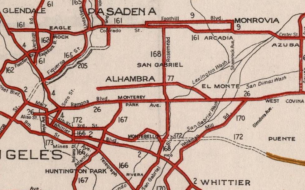
State Maintenance of LRN 26 and US 60 was extended to downtown Los Angeles to Aliso Street during 1933 upon the California State Legislature permitting the Division of Highways to maintain mileage within incorporated cities. A series of September 1934, letters by the California State Highway Engineer to the American Association of State Highway Officials (AASHO) Executive Secretary noted a recommendation to move US 99 from Los Angeles to Redlands via LRN 26 through Pomona and Colton. The California State Highway Engineer noted traffic on US 99 would be better served traversing downtown Los Angeles and utilizing US 60/LRN 26 directly to reach Redlands. Notably the alignment the sketch map provided by the California State Highway Engineer shows existing US 99 following San Fernando Road to US 66 at Arroyo Seco Avenue and a multiplex on US 66/LRN 165 via Figueroa Street to Colorado Boulevard.
The same exchange of letters also notes US 70 had been extended into California with an endpoint following US 60/LRN 26 into downtown Los Angeles. The routing definition of US 70 indicated it would multiplex US 99/US 60 east from downtown Los Angeles to Pomona and onwards to US 60 east to Beaumont.
The 1
934 Division of Highways City Insert implies US 60/LRN 26 followed an interim alignment from downtown Los Angeles eastward following Macy Street, Mission Street, Alhambra Avenue and Valley towards Pomona. The planned Ramona Expressway can be seen as a dotted line connecting Macy Street directly to Garvey Avenue.

The
March 1934 California Highways & Public Works features the upcoming Los Angeles-Pomona Arterial which was to follow what would become the Ramona Boulevard. The Los Angeles-Pomona Arterial is described as being completed from Mountain View Road east to the city limits of Pomona. The Los Angeles-Pomona Arterial is described as having a western extent at Aliso Street and Mission Street in downtown Los Angeles.
The 1935 Division of Highways Map of downtown Los Angeles shows US 99/US 60/US 70 (solid red line) following an interim alignment of LRN 26 east via Macy Street, Brooklyn Avenue and Mednik Avenue towards the completed segment of the Ramona Boulevard. US 99/US 60/US 70 on LRN 26 are shown transitioning from the Ramona Expressway onto Garvey Avenue in Monterey Park. Valley Boulevard is shown at this point to no longer be a State maintained roadway.

The
February 1935 California Highways & Public Works announced the nearing completion of Ramona Boulevard. Construction of Ramona Boulevard is cited as having begun in 1932 and is stated to have six miles containing no grade crossings. Ramona Boulevard is stated to tie in with Aliso Street/Mission Street in Los Angeles east to Garvey Avenue.
The
June 1935 California Highways & Public Works announced the completion of Ramona Boulevard which served as the new alignment of US 99/US 60/US 70/LRN 26 from downtown Los Angeles to Monterey Park. Ramona Boulevard along with improvements to Garvey Avenue are cited as having been dedicated May 25th, 1935.
Despite US 99/US 60/US 70/LRN 26 being realigned onto Ramona Boulevard the Legislature added Valley Boulevard back to the State Highway System as part of Legislative Chapter 626 Section 603. Initially Chapter 626/Section 603 did not add Valley Boulevard and defined it as follows:
"There is hereby added to the state highway system a new route or portion of route from the east city limits of Los Angegles on Valley Boulevard to LRN 26 near El Monte via Valley Boulevard and Pomona Boulevard."
Valley Boulevard was added to
LRN 77 via 1937 Legislative Chapter 841. 1937 Legislative Chapter 841 repealed 1935 Legislative Chapter 626 Section 603 and assigned it LRN 77 segment (a).
1953 Legislative Chapter 237 changed the definition of LRN 77 segment (a) and reassigned it as:
"From the E city limit of Los Angeles to LRN 26 near El Monte."
The new definition of segment (a) of LRN 77 appears on the 1954 Division of Highways Map. Notably LRN 167 and the course of the planned Long Beach Freeway is displayed as connecting with the western terminus of LRN 77 segment (a) at the Los Angeles city limit.
As part of the 1964 State Highway Renumbering the Legislative Route Numbers were dropped in favor of field signage. Subsequently all Legislative Route Numbers lacking a Sign State Route were assigned one. LRN 77 segment (a) on Valley Boulevard was subsequently reassigned as CA 212. CA 212 inherited the definition of LRN 77 segment (a) and first appears on the
1964 Division of Highways Map.
CA 7 and the Long Beach Freeway was completed to CA 212/Valley Boulevard by February 1965. Despite the hanging western terminus of CA 212 being joined to another State Highway the route was deleted by 1965 Legislative Chapter 1372. CA 212 subsequently no longer appears on
1966 Division of Highways Map.


Comments
And I want to go to lone pine California on highway 395.
Let's say...I don't want to go all the way up to Yosemite
And I don't want to go to Bakersfield.
There has to be a way to get to lone pine.
I'm told 180 will take you to mt Whitney.
I'm told you can take 395 to mt Whitney.
Doesn't it seem, then, that I can go from Fresno to lone pine
On this route?