
Chiselville Covered Bridge - Sunderland, Vermont


Also known as the East Arlington Covered Bridge due to its proximity to Vermont's original capital in Arlington, the Chiselville Covered Bridge was built in 1870 and spans over the Roaring Branch of the Batten Kill on Sunderland Hill Road in the Town of Sunderland, Vermont. The name of Chiselville comes from a chisel factory that was once situated in the small village that is also called Chiselville. The covered bridge was built by Daniel Oatman at a cost of $2,307.31 and he used a Town lattice truss design for the bridge's construction.

One thing that you'll notice about this 117 foot long covered bridge is that it sits very high above the river below. The bridge is about 40 feet above the Roaring Branch, lending to an alternative name as the High Bridge. This clearance above the river came in very useful during the devastating floods of November 1927, which caused much damage to covered bridges across Vermont. However, the Chiselville Covered Bridge stayed high and dry. But like many covered bridges, this bridge eventually faced some damage. In 1971, the bridge was severely damaged when two loaded gravel trucks tried to cross at the same time, causing the need for the bridge to be repaired. Supporting steel girders and a center pier were added in 1973 during the bridge's rehabilitation.

Fans of the 1987 movie "Baby Boom" may recall seeing the Chiselville Covered Bridge while watching the film. The bridge was featured in the scene when Diane Keaton’s character leaves New York to move to fictional Hadleyville, Vermont with her daughter for a more peaceful lifestyle. Today, all sorts of people can enjoy the Chiselville Covered Bridge, whether they are taking a motorcycle along scenic back roads or exploring the many covered bridges that Bennington County has to offer between and around its two shire towns.

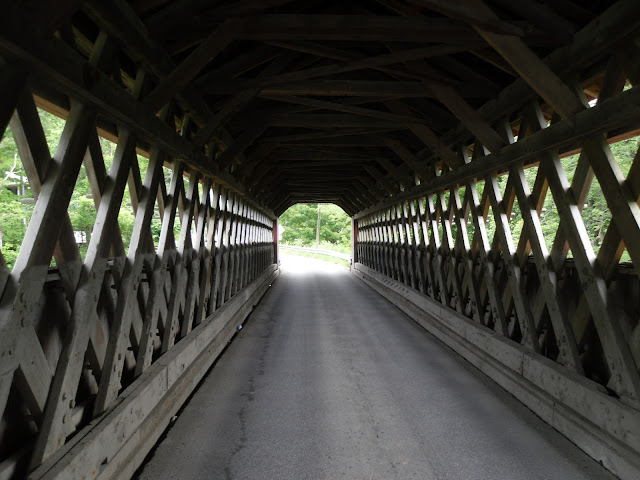
The Town lattice work inside the covered bridge.

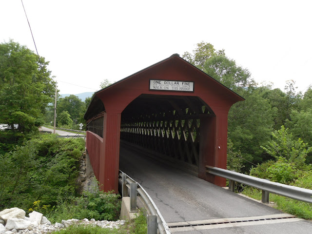
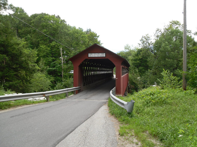
The Chiselville Bridge accommodates one lane of traffic at a time and features a classic sign advertising not to drive faster than a walk on this bridge, or you'll face a fine of $1.

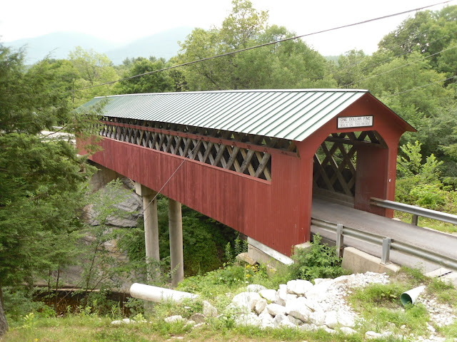
The Chiselville Covered Bridge sits high above the Roaring Branch.


How to Get There:


Sources and Links:
Vermont Covered Bridge Society - Chiselville Covered Bridge
Happy Vermont - Chiselville Covered Bridge in Sunderland
VermontBeginsHere.com - Covered Bridges of Bennington County
Manchester Vermont - Covered Bridges
Bridgehunter.com - Chiselville Covered Bridge 45-02-05
The Travels of Tug 44 - Chiselville Covered Bridge
Back of the Bike Life - Chiselville Covered Bridge-Sunderland, Vermont

Comments

Popular posts from this blog

Did Caltrans just kill the G26 cutout US Route shields?

The US Route System was formally created by the American Association of State Highway Officials during November 1926.  Through the history of the system the only state to which has elected to maintain cutout US Route shields has been California.  The G26 series cutout US Route shields have become a favorite in the road enthusiast hobby and are generally considered to be much more visually pleasing than the standard Federal Highway Administration variant.  However, the G26 shield series appears to have been killed off on January 18, 2026, when Caltrans updated their Manual of Uniform Traffic Control Devices.  This blog will examine the history of the US Route shield specifications in California and what is happening with the 2026 changes.  The blog cover photo is facing towards the terminus of California State Route 136 and at a G26-2 specification US Route 395 shield.  In the background Mount Whitney can be seen in the Sierra Nevada range.   ...

Three Points Road (Los Angeles County)

Three Points Road is a rural cutoff route which connects Pine Canyon Road (Los Angeles County Route N2) and California State Route 138 near Neenach of Antelope Valley.  Originally the community of Three Points (named for the junction Pine Canyon, Oakdale Canyon and Oakgrove Canyon) was served by 265th Avenue West.  The modern three-mile-long corridor of Three Points Road was developed by 1950 to serve as a softer transition to California State Route 138.  Part 1; the history of Three Points Road Three Points Road is named in reference to the community near the extinct Neenach Volcano known as Three Points.  Three Points itself is a reference to three canyons it sits in the middle of: Pine Canyon, Oakgrove Canyon and Oakdale Canyon.  Three Points was homesteaded by the Laffery family in 1892.  Nearby Gookins Lake was named after one of the Laffery family members.   Three Points (blue pin) can be seen at the intersection of Pine Canyon Road (now Los...

Hawaii Route 50

Hawaii Route 50 is the longest Sign Route on the island of Kauai at 32.6 miles.  The entirety of Hawaii Route 50 is overlaid atop Kaumualii Highway from Lihue west to the Pacific Missile Range Facility at Barking Sands. Hawaii Route 50 is one of the original 1955-era State Highway designations on Kauai.  Much of the Kaumualii Highway corridor was constructed during the sugar plantation boom of the late Hawaiian Kingdom.  The first tee beam bridge in Hawaii would be constructed along the Kaumualii Highway in 1911 at the Hanapepe.  Much of this highway would be modernized to two-lane standards through the 1930s and 1940s. This page is part of the Gribblenation Hawaii Roads series.  A compellation of all Hawaii-related media from both Gribblenation and RoadwayWiz can be found by clicking  here .  Part 1; the history of Hawaii Route 50 and Kaumualii Highway Hawaii Route 50 is the longest highway on Kauai at 32.6 miles.  The highway begins at Rice Str...