California State Route 22 is an urban State Highway located in the greater Los Angeles metropolitan area. California State Route 22 begins at California State Route 1 in Long Beach via 7th Street. California State Route 22 eastbound becomes a freeway near the city limit of Long Beach and begins a multiplex on Interstate 405/San Diego Freeway in Orange County. California State Route 22 eastbound departs Interstate 405 onto the Garden Grove Freeway towards a terminus at California State Route 55 in Orange. California State Route 22 contains the notable Orange Crush Interchange which junctions Interstate 5/Santa Ana Freeway and California State Route 57/Orange Freeway. Featured as the blog cover photo is the Orange Crush Interchange shortly after it was completed as depicted in the November/December 1964 California Highways & Public Works.

Notably this blog has a publishing date of 2/22/22. Share with us on the Gribblenation Facebook page your favorite highways containing the number "22." Come see us on 3/3/33 when we celebrate California State Route 33.
Part 1; the history of California State Route 22
During 1933 the State Legislature removed the barriers preventing the Division of Highways from maintaining roads in incorporated cities. This change led to a significant amount of highway mileage being added to the State inventory during 1933. Legislative Route Number 179 (LRN 179) was brought into the State Highway System with the following definition:
"LRN 60 near Long Beach to Santa Ana"
The initial run of Sign State Routes were announced in the August 1934 California Highways & Public Works. California State Route 22 (CA 22) followed the entirety of LRN 179 and carried the following definition:
A map depicting CA 22 can be seen in the August 1934 California Highways & Public Works.
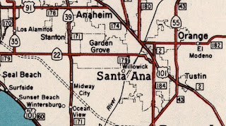
The 1935 Division of Highways Map of Orange County shows the eastern terminus of CA 22/LRN 179 jogging to Ocean Avenue to US Route 101/LRN 2 at Main Street in Santa Ana via Memory Lane, Flower Avenue and 17th Street.
CA 22 can be seen following LRN 179 largely on Ocean Avenue (now mostly Garden Grove Boulevard) from US Route 101A/LRN 60 in Long Beach to US Route 101/LRN 2 at Main Street in Santa Ana on the 1938 Division of Highways Map.
The
March/April 1953 California Highways & Public Works cites the US Route 101/LRN 2 Santa Ana Freeway as having an anticipated completion between Los Angeles and Santa Ana by early 1954. The completion of the Santa Freeway to Santa Ana had an affect on the eastern terminus of CA 22/LRN 179.
The eastern terminus of CA 22/LRN 179 appears to have been pulled north on Main Street in Santa Ana to meet US Route 101/LRN 2 at the Santa Ana Freeway which can be seen on the
1954 Division of Highways Map.
The
November/December 1956 California Highways & Public Works announced CA 22/LRN 179 east from US Route 101A/LRN 60 to Los Cerritos Channel was budgeted to be widened to four lanes for the 1957-58 Fiscal Year. A second project in Orange County showed CA 22/LRN 179 was to be widened from four lanes from Knott Street to Century Boulevard.
Notably the
1957 Division of Highways Map shows a change towards the eastern alignment of CA 22/LRN 179. CA 22/LRN 179 is shown transitioning from Garden Grove Boulevard to Main Street via; Memory Lane, Flower Street, Park Lane (then Boulevard) and Santa Clara Avenue.
It is unclear when the Park Boulevard transition of CA 22/LRN 179 was constructed as it appears on USGS Maps before US Route 101/LRN 2 was shifted to the Santa Ana Freeway in Santa Ana. CA 22/LRN 179 on Park Boulevard first appears on 1949 USGS Map of Santa Ana.
The
January/February 1957 California Highways & Public Works announced the eastern portions of the future CA 22/LRN 179 freeway had been adopted by the California Highway Commission on May 18th, 1955.
1957 Legislative Chapter 36 extended LRN 179 to CA 55/LRN 43 in Orange. This extension of LRN 179 consumed part of what had been
LRN 182 between Main Street and CA 55/LRN 43. The
1958 Division of Highways Map displays the extension of LRN 179 but does not clearly depict it as part of CA 22. LRN 182 had been adopted in 1933 from US Route 101/LRN 2 in Orange east to Orange County Park (Irvine Park).
The
January/February 1958 California Highways & Public Works notes the planned Garden Grove Freeway had been extended (on January 23rd, 1957) in the corridor of CA 22/LRN 182 (the latter is likely an error and intended to be LRN 179) to the planned corridor of the Newport Freeway of CA 55/LRN 43. The article stub was the first acknowledgement that CA 22 had been extended via Main Street and Chapman Avenue in Orange. It is unclear if CA 22 had been extended all the way to Irvine Park via LRN 182 on Chapman Avenue.
The
January/February 1960 California Highways & Public Works provided an update on construction of the conversion of CA 22/LRN 179 into the Garden Grove Freeway. The Garden Grove Freeway between Los Cerritos Channel east to Knott Street is stated to have been completed on July 15th, 1959. The initial segment of the Garden Grove Freeway consisted of the segment which CA 22 multiplexes Interstate 405 today.
The
November/December 1960 California Highways & Public Works announced funding for the CA 22/Garden Grove Freeway and Interstate 5/US Route 101/Santa Ana Freeway interchange for the 1961-62 Fiscal Year. An additional project is stated to be allocated to widen CA 22/LRN 179 on Garden Grove Boulevard between Century Boulevard and Harbor Boulevard to four lanes.
The
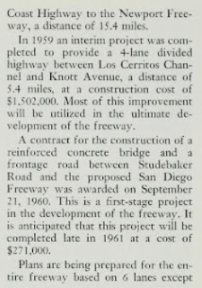
March/April 1961 California Highways & Public Works provides an update on the progression of the Garden Grove Freeway. The article stub notes a western extension of the Garden Grove Freeway from Rio Hondo Channel to the planned Pacific Coast Freeway (US Route 101A) in Long Beach was under restudy.
The
November/December 1961 California Highways & Public Works announced allocations had been made for the 1962-63 Fiscal Year to convert an expressway portions of CA 22 to freeway standards.
The
March/April 1963 California Highways & Public Works provides an update to the CA 22/Garden Grove Freeway. The article stub notes the Garden Grove Freeway/Santa Ana Freeway/Orange Freeway Interchange was anticipated to be completed by the summer of 1964.
A design drawing of the Garden Grove Freeway/Santa Ana Freeway/Orange Freeway Interchange appears in the
March/April 1963 California Highways & Public Works.
The incomplete Garden Grove Freeway/Santa Ana Freeway/Orange Freeway Interchange appears in the
March/April 1963 California Highways & Public Works.
During the 1964 State Highway Renumbering all the Legislative Route Numbers were dropped. CA 22 was definitively extended via what was LRN 182 east of CA 55/LRN 43 via Chapman Avenue to Irvine Park. CA 22 appears as unsigned highway east of CA 55 to Irvine Park on the
1964 Division of Highways Map. Notably the Orange Freeway was assigned as CA 57 as part of the 1964 State Highway Renumbering.


The
March/April 1964 California Highways & Public Works provides an update to the progression of construction of the Garden Grove Freeway. The Garden Grove Freeway/Santa Ana Freeway/Orange Freeway Interchange is stated to have an anticipated completion by August 1964. Conversion of CA 22 to the Garden Grove Freeway between Knott Street and Newland Avenue is stated to be likely completed by mid-year. Funding for the Garden Grove Freeway east of the Garden Grove Freeway/Santa Ana Freeway/Orange Freeway Interchange to the CA 55/Newport Freeway would be provided in the 1965-66 Fiscal Year. Conversion of existing CA 22 west of Los Cerritos Channel to CA 1/Pacific Highway is stated to be anticipated to begin after 1970.

The
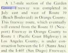
November/December 1964 California Highways & Public Works cites the Garden Grove Freeway/Santa Ana Freeway/Orange Freeway Interchange is cited as being completed during September 1964. A segment of the Garden Grove Freeway west of CA 39/Beach Boulevard is cited as having been completed by July 1964. The Garden Grove Freeway/Santa Ana Freeway/Orange Freeway Interchange came to be known in time unofficially as the Orange Crush Interchange. The "Orange Crush Interchange" nickname allegedly was coined by KNX Radio traffic reporter Bill Keene as a play on Orange Crush soda.
1965 Legislative Chapter 1372 truncated
CA 22 from Irvine Park to CA 55. What was CA 22 east of CA 55 to Irvine Park on Chapman Avenue was added as part of
Orange County Route S18 when it was commissioned in 1970.
The
March/April 1965 California Highways & Public Works provided a progress report on the construction of the Garden Grove Freeway. A 2.5-mile segment of the Garden Grove Freeway from Knott Street to Garden Grove Boulevard is stated to be likely complete by 1966. A segment of Garden Grove Freeway from Newland Street to near Hester Street is stated as having an anticipated completion during 1965. The remaining 1.9-miles of the Garden Grove Freeway east of the Santa Ana Freeway to CA 55/Newport Freeway is stated to have a targeted construction groundbreaking before the end of 1965.
The
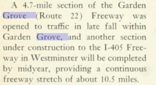
November/December 1965 California Highways & Public Works announced a new 4.7-mile segment of the Garden Grove Freeway opened during the previous Fall. Completion of conversion of CA 22 as the Garden Grove Freeway in Westminster west to Interstate 405 is stated to be anticipated to be completed by midyear 1966.
Notably the relinquished portion of CA 22 east of CA 55 to Irvine Park is shown as retained on the
1966 Division of Highways Map. This routing was likely retained in interim until CA 22 reached CA 55 via the extension of the Garden Grove Freeway.
The California Highways & Public Works publication ended during early 1967. Bridge stamp dates show CA 22 and the Garden Grove Freeway were completed to the CA 55/Newport Freeway during 1967. Thusly the completed Garden Grove Freeway between Interstate 5 and CA 55 appears on the
1967 Division of Highways Map. CA 22 is shown to be rerouted off of Main Street and Chapman Avenue to reach CA 55 via the Garden Grove Freeway.
1972 Legislative Chapter 150 deleted the Garden Grove Freeway extension west to CA 1 in Long Beach. This measure ensured CA 22 remained on 7th Street where it still meets CA 1/Pacific Coast Highway at its western terminus.
Part 2; a drive on California State Route 22
Our tour of CA 22 begins from Interstate 5/Santa Ana Freeway northbound Exit 106 which accesses CA 22/Garden Grove Freeway westbound via the Orange Crush Interchange. Interstate 5 northbound Exit 106 does not contain a movement to eastbound CA 22.
CA 22/Garden Grove Freeway westbound crosses the Santa Ana River, enters the city of Orange and accesses The City Drive at Exit 14A.
CA 22/Garden Grove Freeway Exit 13 accesses Hester Street.
CA 22/Garden Grove Freeway Exit 12 accesses Harbor Boulevard.
CA 22/Garden Grove Freeway westbound Exit 11 accesses Euclid Avenue.
CA 22/Garden Grove Freeway westbound Exit 10 Brookhurst Street.
CA 22/Garden Grove Freeway westbound Exit 9 accesses Magnolia Street.
CA 22/Garden Grove Freeway westbound Exit 8 accesses CA 39/Beach Boulevard.
CA 22/Garden Grove Freeway westbound Exit 7 accesses Knott Street and Goldenwest Street.
CA 22/Garden Grove Freeway enters Garden Grove and accesses Valley View Street/Bolsa Chica Road at Exit 5. Interstate 405 southbound traffic is directed to depart CA 22 via Exit 5.
CA 22 westbound enters Seal Beach and begins a multiplex of Interstate 405/San Diego Freeway northbound. Interstate 405 northbound Exit 22 accesses Seal Beach Boulevard. CA 22 westbound departs Interstate 405 via Exit 23 towards 7th Street in Long Beach.
CA 22 westbound enters the city of Long Beach at the Los Angeles County Line upon crossing the San Gabriel River.
The western segment of the Garden Grove Freeway ends as CA 22 passes Exit 1 at Studebaker Road.
CA 22 westbound crosses Los Cerritos Channel and follows 7th Street to a terminus at CA 1/Pacific Coast Highway.


Comments