Rim Drive of Crater Lake National Park is a 33 mile loop around the volcanic caldera of the namesake lake. The earliest iteration of Rim Drive (Rim Road) was completed by 1918 and the current facility was completed by 1941. Modern Rim Drive is presently listed on the National Register of Historic Places. Depicted above is Wizard Island from Rim Drive during the winter of 2016. Modern Rim Drive can be seen depicted below on the 1944 Rand McNally/State Farm Highway Map of Oregon.
Part 1; the history of Rim Drive
Crater Lake is the volcanic caldera of what is known as Mount Mazama. Presently the peak elevation of Mount Mazama consists of a 8,157 foot high portion of the rim above Crater Lake. Mount Mazama is thought to have been at least 12,000 feet high before it experienced a major eruption approximately 7,700 years ago. The eruption 7,700 years ago was powerful enough to empty the magma chamber beneath Mount Mazama which collapsed into the void left behind. The collapse of Mount Mazama formed a caldera which filled with water up to a depth of 1,943 feet creating Crater Lake. The collapse of Mount Mazama is thought to have been carried through oral traditions of the local Klamath tribes.
Much of the history pertaining to Rim Drive can be found on the NPS.gov article below:
Crater Lake National Park: History of Rim Drive (nps.gov)
Crater Lake was first observed by Europeans when gold prospectors stumbled upon it on June 12th, 1853. Even before it was a National Park the waters of Crater Lake were attractive for early tourism on the American West Coast. In 1863 the Army Outpost of Fork Klamath was established near Crater Lake in the northern extent of the Klamath Basin. Subsequently a stage road was constructed in 1865 from the mining town of Jacksonville across the Cascade Range via the Rogue River and Annie Creek to Fort Klamath. This new stage road passed directly south of Crater Lake and allowed for relative ease of access by 19th Century standards. The stage road between Jacksonville and Fort Klamath forms the generalized corridor of Oregon Route 62 ("OR 62") and can be seen on the 1872 Bancroft's Map of Oregon, Washington, Idaho, Montana and British Columbia.

In 1869 a group led by the editor of the Jacksonville Newspaper visited Crater Lake via the Jacksonville-Fort Klamath stage road. The expedition by the Jacksonville Newspaper named Crater Lake and visited Wizard Island. The expedition to Crater Lake by the Jacksonville Newspaper was published and widely distributed leading to a tourism boom. In 1886 a USGS expedition fully surveyed Crater Lake and Wizard Island. The 1886 USGS expedition along with lobbying led Congress to approve the creation of Crater Lake National Park on May 22nd, 1902.
In 1905 a road extending from the Jacksonville-Fort Klamath Stage Road to the rim of Crater Lake was constructed from Munson Valley. This connecting road to the rim of Crater Lake began near Annie Creek and ascended to the present location of Rim Village. A circuit road around the rim of Crater Lake was seen as a desirable way of allowing tourism to access all areas of Crater Lake National Park. Subsequently construction of "Rim Road" around Crater Lake began in 1913 under the supervision of the Army Corps of Engineers. Construction of the Rim Road began from what was to be the East Entrance road to Crater Lake National Park to Lost Creek. From Lost Creek construction of the Rim Road progressed westward towards Munson Valley and counter clockwise around Crater Lake. Rim Road was incorporated into the initial run of State Highways when the
Oregon State Route System was created on November 27th, 1917 as The Rim Highway #24.
Rim Road can be seen on a
1917 Oregon Highway Commission Map of proposed State Highways as The Rim Highway #24. The Jacksonville-Fort Klamath Stage Road is shown to be assigned as Medford-Crater Lake Highway #22 and Klamath-Crater Lake Highway #23.
The 35.6 mile Rim Road was functionally completed by October 1918 and was turned over the National Park Service rather than the Oregon Highway Commission during July of 1919. The National Park Service at the time was a relatively new entity having been created on August 25th, 1916. Ultimately Oregon Highway #24 would be reassigned to the Burns-Crane Highway in 1926.
On December 9th, 1924 Oregon Highway #22 was consolidated with Oregon Highway #23 to form the Crater Lake Highway.

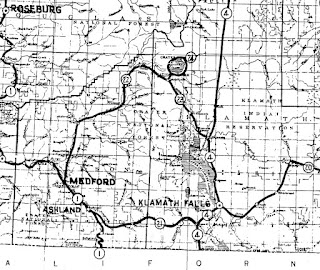
Rim Road can be seen circling Crater Lake on the 1925 Rand McNally Map of Washington and Oregon as part of the National Park-to-Park Highway. Part of Rim Road can be seen signed towards the East Entrance Road as part of the California Banff "B" Line. The National Parks Highway can be seen terminating at Crater Lake National Park.

The US Route System was created in late 1926 which brought US Route 99 (Pacific Highway #1) and US Route 97 (The Dalles-California Highway #4) to the vicinity of Crater Lake Highway #22 and Rim Road. Existing Rim Road was becoming functionally inadequate to facilitate modernized automotive travel which led the National Park Service and Bureau of Public Roads to seek solutions to facilitate increasing tourism traffic. Grades higher than 8% coupled with numerous excessive turning radius points were targeted by the National Park Service and Bureau of Public Roads to be eliminated from Rim Road. US Route 99 ("US 99") and US Route 97 ("US 97") can both be seen connecting on opposite ends of Crater Lake Highway #22 on the
1927 Rand McNally Map of Oregon. Rim Road can be seen still assigned as The Rim Road #24 in error.

Reconstruction of Rim Road began during summer of 1926 with the rebuilding of the South Entrance road to Rim Village. This early segment of reconstructed Rim Road increased the width of the existing road to 20 feet and reduced the maximum incline to Rim Village from 10.9% to 6.5%. A initial survey for the improvement and relocation for the entirety of Rim Road was completed by the Bureau of Public Roads during 1926.
Advertisement for bids on the construction of western Rim Drive from Rim Village to North Junction (also known as Diamond Lake Junction) was released by the National Park Service and Bureau of Public Roads on May 1st, 1931. A contract was awarded to P.L. Crooks Construction which began work during June 1931. Rim Drive unlike it's predecessor was designed with 5% grades in mind compared to the occasional grades in excess of 8% seen on Rim Road. In 1932 the Oregon Transportation Commission assigned the initial run of signed Oregon Routes. Oregon Route 62 was applied to Crater Lake Highway #22 which provided numbered highway access between US 99-US 97 and Crater Lake National Park.
Advertisement for construction bids for northern Rim Drive from North Junction to Grotto Cove were put out during the fall of 1932. Construction of eastern Rim Drive from Grotto Cove to Kerr Notch was awarded during September of 1933. Construction of the North Junction-Grotto Cove segment of Rim Drive began during October 1933. Paving of western Rim Drive between Rim Village and North Junction was completed by October of 1935. A partially completed Rim Drive and OR 62 can be seen in the vicinity of Crater Lake National Park on the
1935 Gousha Highway Map of Oregon.

The 1934 Oregon State Highway Department Sign Route descriptions (courtesy Jonathan Ledbetter) show OR 209 designated as a Secondary Oregon Route originating from OR 62 in Munson Valleyand following western Rim Drive to the North Entrance of Crater Lake National Park. OR 232 is shown as a Secondary Oregon Route originating at OR 209 and following existing Rim Road to the East Entrance of Crater Lake National Park to US 97. Neither OR 209 and OR 232 initially were designated over segment of highway maintained by the Oregon Highway Department.


Northern Rim Drive from North Junction to Grotto Cove was surfaced by crushed rock and oil by 1936. A construction contract for southern Rim Drive from Kerr Notch and Sun Notch was awarded during late summer 1936. Much of eastern Rim Drive between Grotto Cove and Kerr Notch was surfaced by Fall 1937. The completed western Rim Drive can seen on the
1937 Gousha Map of Oregon. The 1937 Gousha Map shows the Northern Entrance road Rim Drive signed as OR 209 and the Eastern Entrance road signed as OR 232.
OR 232 was added to the State Highway System as Sand Creek Highway #424 along with OR 209 as part of Crater Lake North Highway #232 on May 18th, 1937. It is unclear if OR 209 and OR 232 were ever actually field signed in Crater Lake National Park.
Construction of grading southern Rim Drive from Sun Notch to the Crater Lake National Park headquarters began during 1938 and was completed by 1939. Rim Drive can seen completed from North Junction to the Grotto Cove on the
1939 Rand McNally/State Farm Map of Oregon.
Grading of southern Rim Drive between Kerr Notch-Sun Notch and was paved with temporary materials due to difficulties quarrying aggregate coupled with the onset of the United States entering World War II during 1941. Similarly the remaining segment of Rim Drive from Sun Notch to the Crater Lake National Park Headquarters was given a temporary oil surface during 1941. The 1
940 Rand McNally/State Farm Map of Oregon displays Rim Drive completed from Kerr Notch what is now Pinnacles Road. A graded segment of Rim Drive from the Pinnacles Road westerly past Sun Notch towards the Crater Lake National Park headquarters can be also observed.
The completed Rim Drive can be seen on the
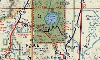
1944 Rand McNally/State Farm Map of Oregon. Rim Drive reduced the circuit of Crater Lake to 33 miles compared to 35.6 miles utilized by Rim Road. Current Greyback Road from Vidae Falls and the Pinnacles Road to Kerr Notch are recycled portions of the original Rim Road.
During the late 1940s US 97 was shifted east from what is now Sun Mountain Road near Klamath. The original alignment of US 97 on Sun Mountain Road was spun off into Sun Mountain Highway #428 on August 9th, 1948. The shift of US 97 led to a sharp decline in vehicle traffic entering the Crater Lake National Park National Park East Entrance via OR 232. OR 232 seemingly was extended via dual spur on the entirety of Sun Mountain Highway #428.
On November 20th, 1952 Sand Creek Highway #424 was transferred from the Oregon Highway Commission to the United States Forest Service.

Despite Sand Creek Highway #424 being transferred to the Forest Service it still appears on the
1956 Shell Highway Map of Oregon as part of OR 232 from Sun Mountain Highway to the Eastern Entrance of Crater Lake National Park. Notably OR 209 is not depicted on the Shell Highway Map despite Crater Lake North Highway #232 still terminating at the North Entrance of Crater Lake National Park.
According to the
Crater Lake Institute the East Entrance to Crater Lake National Park was closed during the summer of 1957. Traffic through the East Entrance to Crater Lake National Park had fallen to 4% of it's peak volume before the relocation of US 97. The East Entrance road was reopened on September 1st, 1971 but only saw 2.5% of visitors utilize it to enter Crater Lake National Park. The National Park Service closed the East Entrance for good during September of 1972 which culminated with the pavement being removed. The East Entrance boundary sign can still be found as depicted by the photo taken by
Larry Eifert of the Crater Lake Institute.
On February, 28th 1984 Crater Lake North Highway #232 was largely disbanded with a segment being relinquished to Crater Lake National Park approaching the North Entrance. The remainder of Crater Lake North Highway #232 was consolidated with East Diamond Lake Highway #425. .
Part 2; a drive on Oregon Route 62 and Rim Drive through Crater Lake National Park
The tour of the Rim Drive corridor begins in Rogue River-Siskiyou National Forest near Union Creek of Jackson County at the Natural Bridge viewing area in the Rogue River Gorge.
The Natural Bridge viewing area contains a crossing of the Rogue River which has it's source upstream at Boundary Springs of Crater Lake National Park. The course of the Rogue River carries it out of the Cascade Range to the Pacific Ocean at Gold Beach.
The Natural Bridge of the Rogue River is a lava tube through which the main water flow is channelized through. The lava tubes which make up much of the upper Rogue River lend evidence to the volcanic past of the area tied to Mount Mazama.
Continuing north from the Natural Bridge viewing area OR 62 crosses Union Creek and enters the small community of the same name.
Union Creek received Post Office Service during 1924 and contains a historic district which consists of 1930s era Civilian Conservation Corps ("CCC") structures. These structures housed workers during the reconstruction of Rim Road into Rim Drive.
Beckie's Cafe has been in continuous operation at Union Creek since 1926 and is known for it's fresh pies.
The Rogue River Gorge overlook can be found in Union Creek. The overlook in Union Creek views a portion of the Rogue River which has eroded away a lava tube.
Part of the grade of the original Crater Lake Highway can be found at the Rogue River Gorge overlook. The original alignment of the Crater Lake Highway was shifted in the 1950s when OR 62 was relocated and has since overgrown.
North of Union Creek OR 62 intersects OR 230 where the former turns eastbound towards Crater Lake National Park. Crater Lake National Park is signed as 23 miles to the east of the OR 230 junction.
At the Klamath County Boundary OR 62 enters Crater Lake National Park via the West Entrance.
OR 62 eastbound within Crater Lake National Park intersects Munson Valley Road which is signed as primary access to Rim Drive.
A entrance station can be found on Munsen Valley Road at Mazama Village.
Munson Valley Road crosses Annie Creek and jogs northward to an intersection with Rim Drive near the Crater Lake National Park Headquarters. Rim Village is signed as 3 miles away from the Crater Lake National Park Headquarters on western Rim Drive.
Western Rim Drive climbs from Munson Valley to the rim of Crater Lake and Rim Village.
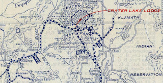
Rim Village is also a Historic District which was built up upon the earliest segment of Rim Road opened in 1905. In 1907 Camp Crater Lake was established at the future site of Rim Village. From 1909 through 1915 the Crater Lake Lodge was constructed and is now the feature structure of Rim Village. The stone vista of Crater Lake at Rim Village was constructed during 1921 which was followed by most of the visitor buildings in 1924. The below pictures were taken during August of 2021 during the worst smoke periods of the Dixie Fire.
Views of Crater Lake from Rim Village during March of 2016.
Traffic departing Rim Village is directed to take western Rim Drive to reach OR 138.
Western Rim Drive is signed as 6 miles from North Junction and 11 miles from the Cleetwood Trail.
Numerous vistas line western Rim Drive which overlook Crater Lake and Wizard Island.
The same view during August 2021 versus March 2016.
Western Rim Drive passes by the Lightning Springs Trailhead.
Western Rim Drive begins to swing northward and intersects the Watchman Overlook.
The
Watchman Observation Station can be seen atop Watchman Peak. The trail up Watchman Peak was constructed in 1916 which was followed by a fire tower in 1917. The present Watchman Observation Station was constructed from 1931-33.
Wizard Island can be seen prominently from the Watchman Overlook. Wizard Island is a volcanic cinder cone which rises to an elevation of 6,933 feet above sea level and has a prominence of 755 feet on average above Crater Lake. Wizard Island is presently the highest volcanic cone at Crater Lake at 2,700 feet beginning from the lake bottom.
The same view from the Watchman Overlook during June 2014.
Western Rim Drive continues northward to a junction with the North Entrance Road near Merriam Point. Eastern Rim Drive swings eastward following the north rim of Crater Lake. Access to the Cleetwood Cove Trail is signed via eastern Rim Drive.
Eastern Rim Drive follows the north rim of Crater Lake eastward 4.6 miles to the Cleetwood Cove Trailhead parking area.
The
Cleetwood Cove Trail is 1.1 miles in length and is the only trail which accesses the waters of Crater Lake. The Cleetcove Trail is steep as it descends 700 feet which is roughly equal to 65 flights of stairs. Visitors are allowed to swim within 100 yards of Cleetwood Cove and during non-pandemic years a boat tour to Wizard Island is offered. The surface water temperature of Crater Lake generally only reaches a high of 57F during the summer months.
Rim Drive east of the Cleetwood Cove Trail begins to turn south on the eastern rim of Crater Lake and intersects the access road to the Cloudcap Overlook.
The Cloudcap Overlook provides access to a full view of Crater Lake facing westward.
Returning to Rim Drive the Cloudcap Overlook road faces Mount Scott. From the Cloudcap Overlook Road eastern Rim Drive swings southwest towards the Phantom Ship Overlook at Kerr Notch. The Phantom Ship is the second and smallest island in Crater Lake and is a remaining part of the volcanic cone of Mount Mazama. At Kerr Notch eastern Rim Drive intersects the Pinnacles Road which was where Rim Road originally turned from the rim of Crater Lake towards the Eastern Park Entrance.
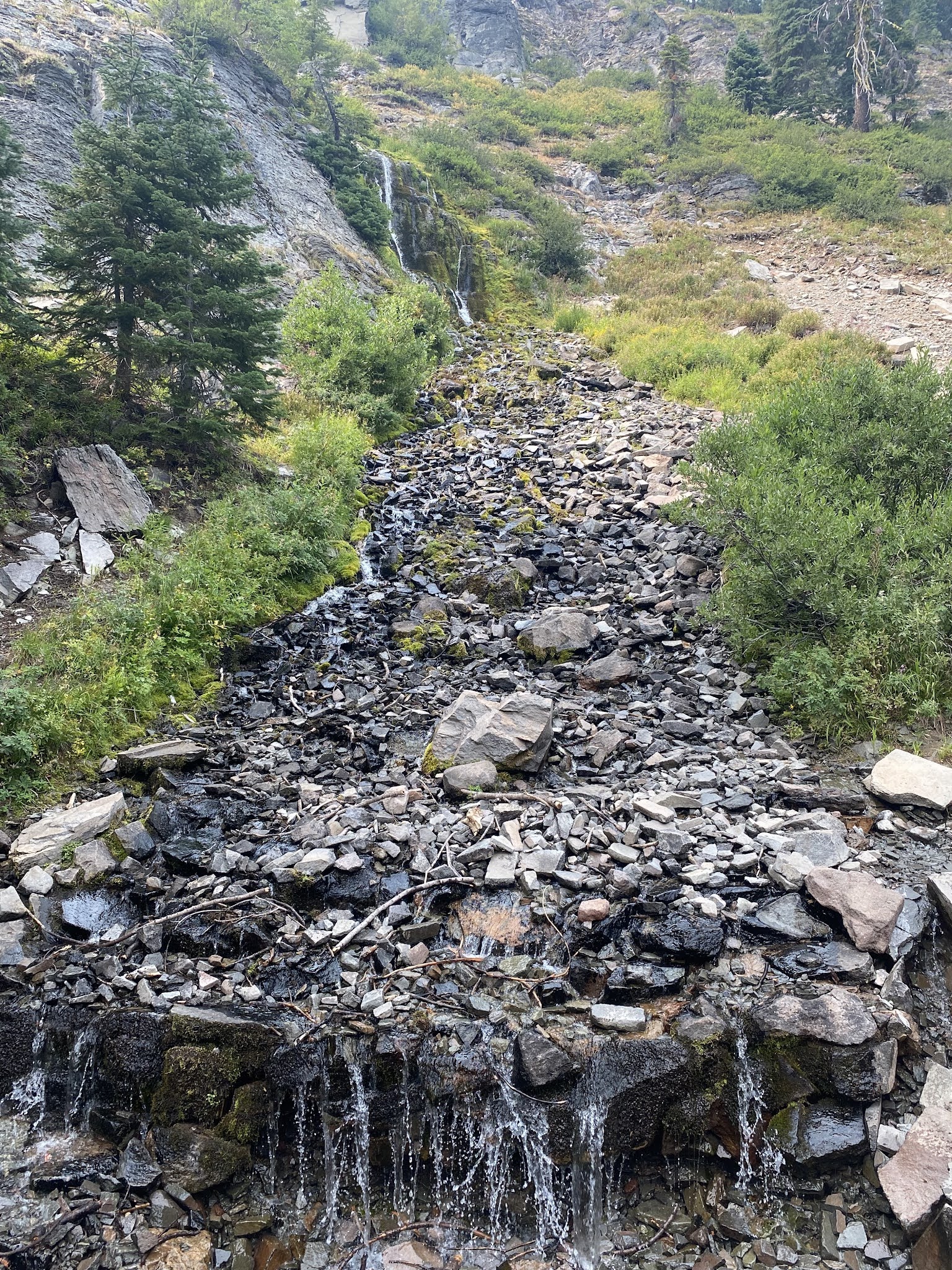
Eastern Rim Drive continues southwest below the rim of Crater Lake and intersects Greyback Road at Vidae Falls. Greyback Road is the opposite end of what was the original Rim Road. Vidae Falls is approximately 115 feet high and is formed from seepage from Crater Lake through the southeast rim.
Rim Drive completes it's circuit of Crater Lake west of Greyback Road as it loops back to Munson Valley Road at the Crater Lake National Park Headquarters.
Returning to OR 62 traffic headed east on the Crater Lake Highway is informed Klamath Falls can be reached in said direction.
US 97 is signed 30 miles from the Munson Valley Road on eastbound OR 62. Fort Klamath can found 15 miles east of Munson Valley Road on OR 62.
Eastbound OR 62 is signed as part of the Volcanic Legacy Scenic Byway.
OR 62 eastbound descends to the Klamath Basin and passes through Fort Klamath. After the establishment of Fort Klamath a small community began to develop around the military fortification. Fort Klamath grew substantially enough to merit Post Office Service beginning in 1879. In 1889 a decision to disband Fort Klamath was made and the 14th Infantry Regiment moved to Vancouver on the Columbia River in June of 1890.
OR 62 east of Fort Klamath intersects former US 97 at Sun Mountain Road. Sun Mountain Road is signed as access to the Kimbal Recreation Site.
OR 62 eastbound terminates at modern US 97. Traffic heading to Klamath Falls is directed to use US 97 southbound.


Comments