
Before modern highways full of asphalt and concrete and before a uniform route numbering system existed in the United State let alone Virginia, a series of named 'Auto Routes' or 'Auto Trails' blanketed the country. Some like the Lincoln Highway and the Dixie Highway were national routes maintained by coalitions that promoted and signed the trails with painted poles or stone markers. Others were well posted in one state and forgotten in another. Finally, within the state themselves were series of auto trails many named as a city-to-city route. In Virginia, one of these trails became known as the 'Seminole Trail.' The Seminole Trail would run north-south through Central Virginia from Warrenton to the North Carolina State Line south of Danville.
The Seminole Trail was named by an act of the Virginia General Assembly on February 16, 1928. Today, US 29 is known as the Seminole Trail from Danville to Warrenton.
Same Road; New Numbers, Early 1920's-1932:
As states began to number principal roads and created a statewide system of highways and maintenance, many named trails now became known as a single number or in the case of what would become the Seminole Trail, multiple numbers. From Danville to Lynchburg, VA 14 was the assigned route number. VA 18 then took over the Lynchburg to Charlottesville segment. From Charlottesville to Culpeper, the future Seminole Trail picked up the VA 28 designation. Finally, VA 32 carried the torch from Culpeper to Warrenton.
Could the Seminole Trail have followed the original VA 28 from Culpeper to Warrenton via Jeffersonton? Well, looking at the 1942 State Map at right, that possibility does exist. Old VA 28, which in 1942 was VA 29 (totally unrelated to US 29), was the route of the trail from Charlottesville to Culpeper. If this is correct, the original Seminole Trail follows modern-day VA 229 (which replaced VA 29 in the late 1940s) to near Jeffersonton. The Trail would then follow Secondary Route 802 from VA 229 to Warrenton. It is unclear at this time whether or not the Seminole Trail did follow this route; or if it did follow what was then VA 32. In modern times, the current US 29 route from Culpeper to Warrenton is designated as the Seminole Trail.
With the birth of the US Highway System in 1926, new numbers were added to the trail. US 170 would share the road with VA 14 into Lynchburg. Later in 1929, US 15 would take over VA 32 from Culpeper to Warrenton. By the early 1930's, VA 14 would leave also. During this ten plus year period, changes were made to the alignments as roads were improved and straightened.
One Number for One Trail:
Uniformity came to the Seminole Trail in 1932, when US 29 which had terminated in Kings Mountain, North Carolina was extended along then US 170 into Lynchburg. US 29 didn't stop there, as it continued into Charlottesville along VA 18 and towards Culpeper on VA 28. As a result, both VA 18 and VA 28 were no longer signed on the trail. Two years later, US 29 would be extended through Virginia and into the nation's capital along US 15 and US 211.
 Since then, US 29 has gone through numerous changes; most noticeably over 95% of the route being widened to four or more lanes. In the middle of the twentieth century, US 29 moved onto a straighter alignment from Amherst to Lovingston. Beginning in the 1950's, numerous towns: Gretna, Chatham, Hurt, Altavista, Amherst, Lovingston, and Madison would be bypassed. Also, cities that include Danville, Lynchburg, Charlottesville, Culpeper, and Warrenton would see limited access bypasses. These upgrades were a result of the establishment of the Virginia Arterial Highway System in 1964. US 29 would be included in this system from the North Carolina State Line to Interstate 66 near Gainesville. As the 21st Century began, more extensive bypasses were built, planned or discussed in Danville, Lynchburg/Madison Heights, and Charlottesville. The Lynchburg/Madison Heights Bypass was added to the arterial network in 1990 and completed in 2005.
Why call it 'Seminole Trail'?:
 That's a good question, and really no one knows for sure. A February 22, 2004 Washington Post Article that featured this site gives some clues to the possible naming. The 1928 Act, known as Senate Bill 64 that gave the route its name, gives no reason of why or who suggested the name. Many believe that the road was named such to attract tourists through the area on their way to Florida. This theory is strengthened by the fact that many road maps of the 30s and 40s list the Seminole Trail on highways in the Carolinas, Georgia and ultimately Florida. While these maps show 'Seminole Trail', Virginia is the only state that has kept the name. In fact, there is no proof that the other states even signed the route as such. Although many auto trails of the era, like the Lincoln Highway, had distinguished markings for navigation of their routes. It is unknown if the Seminole Trail did. Today, Virginia places small Seminole Trail guide signs, like the photo at right, along the entire length of the trail. The small guides usually are placed after major intersections.
Other Designations:
US 29 is also known by other names in Virginia. From Warrenton to Washington, DC, US 29 is part of the Lee Highway, named after former Confederate General Robert E. Lee. Of course in various towns and counties, US 29 may have a different name than 'Seminole Trail'. It also shares the James Madison Highway designation with US 15 in Northern Virginia, and the entire route is named in honor of the 29th Infantry Division.
Danville:
 US 29 has a colorful history in and around the Dan River city of Danville. Coming in from the Piedmont of Central North Carolina, US 29 had entered the city via W. Main St. Since then, US 29 has seen two route changes and various bannered additions and deletions. Danville was first settled in 1793 and has served as a tobacco and textile center since it's incorporation in 1835. It is known as "The Last Capital of the Confederacy" as Jefferson Davis resided at the Sutherlin Mansion in early April 1865. Main St. which mainline US 29 ran on until 1971 is known as Millionaire's Row numerous Victorian and Edwardian homesteads built as a result of many tobacco and textile fortunes. One year later, Main St., now Business US 29, became part of the Old West End Historic District in an effort to preserve and maintain many of these existing sites.
However as early as the mid 1930s, attempts were made to divert through traffic from the West End. A short-lived Alternate US 29 existed from about 1932-1942, running along Worsham Street and tying into Main on the north shore of the Dan River. A second and longer lasting Alternate route was posted in 1942 and stayed to the west of town. It followed Memorial Drive, crossed the Dan west of downtown, and followed north on Piney Forest Road until returning to US 29 near Blairs. In 1971, this route was redesignated Bypass US 29 and the original US 29 became known as Business US 29.
 Twenty-five years later, US 29 would be moved to the east of downtown and of historic Main Street. In 1998, US 29 was placed on the Danville Expressway (former VA 265) and Dan Daniel Memorial Highway. The former Bypass US 29 was now named Business US 29, and the original US 29 became VA 293. On VA 293, the highway crosses over the Dan River on an open spandrel rib arch bridge built in 1927. Also in 1998, the Danville Expressway and Bypass received 'Future' I-785 corridor shields along with the US 29 designation. Eventually, Interstate 785 will continue South into North Carolina to Greensboro. US 29 now enters into Virginia as a freeway, and for years motorists found the highway as a very involved construction site. Much of the construction going on at the time was for the western half of the Danville Bypass that now carries US 58. While the freeway was being expanded west, additional work was done to the Dan Daniel Memorial Highway -- the northeast segment of the bypass. The construction project upgraded the highway to four lanes of limited-access freeway. The project which included four new bridges was completed in late 2003.
There remains some slight highway upgrades needed to the US 29 freeway bypass of Danville. Just north and east of its junction with US 58 at the State Line, there had a been a series of at-grade intersections. Slowly, the grade crossings have been removed - and to be replaced with future interchange. One such instance occurs at Elizabeth Street. Stub ramps for the future interchange are in place, but there are currently no plans to improve the intersection to a full diamond interchange.
Blairs to Lynchburg:
US 29 continues northward as the transition from the Southern Virginia Piedmont to the foothills of the Appalachian Mountains begins. US 29 is a four lane ribbon of highway winding through the countryside. The mainline no longer visits towns like Chatham and the numerous churches there. Nor does it visit the downtowns of Gretna, Hurt, or Altavista. However, in between these small towns, the rural charm of South Central Virginia continues to be showcased. In the upcoming years, many changes may occur to the US 29 landscape. The Virginia Department of Transportation US 29 Corridor Study has suggested the building of a US 29 freeway throughout this segment. This freeway would include the current existing bypasses of Chatham, Gretna, and Hurt-Altavista. These existing bypasses and interchanges would be upgraded to modern standards. The rest of the freeway would be built on a new alignment, replacing the four lane road that in some cases was widened as recently as the mid-1970s.
The Town of Chatham is known for its 'Old South' charm and numerous Victorian Era homes. It is a small town of 1300, and the small central area doesn't seem to miss the traffic speeding by on the bypass built to the east in 1965. Business US 29, the old route through town, is lined with storefronts, a fabulous courthouse built in 1853, and many beautiful and architecturally stunning homes. Business US 29 rides through Chatham on Main Street, and on the north end of town there is a wide sweeping curve as you exit Chatham. This curve is a result of a successful petition in 1832 by Dr. Robert Coles, whom the homestead was built nearby. "He wanted his new house to be situated in a grove of oak trees, which, inconveniently, was the location of the main road north from the town." His petition proved successful and what is now Main Street was moved several yards to the west.
Gretna would be bypassed a decade later in 1975. Visitors entering Gretna are greeted with the slogan: "Town of Gretna. 'Ain't No Big Thing, But It's Growing.' (see right photo) Gretna's strong ties to the local agricultural community earned it a depot on the Virginia Midland Railroad which was known as Franklin Junction in 1876. Franklin Junction would later become Gretna.
The next bypass on US 29 is of two towns. The two Staunton River towns of Hurt, on the South shore, and Altavista, on the North shore, were bypassed in 1974. Both towns are relatively young compared to the rest of the state. Altavista, the larger of the two, was incorporated in 1912. Hurt, although settled via a land grant to Benjamin Clements in 1741, was incorporated 1967, three years after the death of John L. Hurt, Jr. A highlight of Altavista is the 'First Saturday Trade Lot' an over 50-year old tradition where residents sell and trade numerous goods.
Just beyond the north end of the Altavista Bypass is a hidden treasure of the old highway. Along what is now Secondary Route 712 sits a vintage 1927 truss bridge over the Otter River. The bridge, which carried the Seminole Trail and US 29 until 1953, is still serviceable today.
Lynchburg:
Lynchburg is known as "The City of Seven Hills," and it is here where US 29 goes from a rural piedmont highway to hugging the eastern slopes of the Blue Ridge Mountains. US 29 has a colorful past in the Lynchburg area. Now, US 29 has a new chapter added to its Lynchburg story, the Madison Heights Bypass has moved US 29 east of the city and off the 1960s era Lynchburg Expressway. This along with the upgrading of the Danville Bypass are the first two modernization projects for US 29 that may lead to an Interstate designation. Many residents of Lynchburg had voiced their concern that the new highway will take away from traffic from downtown Lynchburg.
 The Lynchburg Expressway began in the 1950s and was built in bits and pieces until a formal completion in the early 70s. It was at this time when what was once US 29 Alternate, one of the early original routings of US 29 through town, became the current US 29 Business. This route follows Wards Rd, Fort St., Madison Heights. Prior to that, another Alternate US 29 took motorists along 12th and Main St. through Downtown Lynchburg, before joining US 29 on the South Shore of the James. This route existed from the mid-1940s to the early 1950s, when the first parts of the Lynchburg Expressway were being built and opened. Some of VA 128 has taken over the original route. The Lynchburg Expressway is somewhat different than most non-Interstate Freeways/Expressways in the Commonwealth. It employs sequential exit numbers on its entire length. The Expressway also carries separately, US 501, to the west of the city. US 29 Business through Madison Heights is heavily congested and has numerous stop lights and strip malls.
The Madison Heights bypass routes US 29 to the south and east of Lynchburg and ties back into current US 29 at the southern end of the Amherst Bypass. The first two mile segment of the road opened in late December of 2004. Introduced in segments, the highway was completely opened to traffic on October 6, 2005. US 29 now joins US 460 at the Ward Road interchange, heads east with US 460 and then turns north on its own alignment near the Campbell/Amherst County Line. The new freeway includes connections with the Lynchburg Expressway. Plus, VA 130 and VA 210 has been extended to meet the new road. The Madison Heights Bypass was included in the 1990 expansion of the Virginia Arterial Highway System.
The proposed South Lynchburg Bypass would carry US 29 on a new alignment from US 460 south and westwards to where VA 24 meets US 29. The state filed a letter of intent for an Environmental Impact Study with the EPA in February of 2002. The study consists of "...combination of improvements including the construction of a four-lane divided limited access highway on new location and the improvement of existing facilities. Where alternatives overlap existing Route 460, a six-to-eight lane typical section on Route 460 would be necessary. The length of the proposed improvement ranges from 12.8 miles to 21 miles depending upon the alternative being considered." If completed, the South Lynchburg Bypass will take US 29 traffic away from a very congested route that currently consists of five traffic signals between VA 24 and US 460. South of VA 24 to the NC line there is only one traffic signal on US 29.
Madison Heights to Charlottesville:
 The Seminole Trail continues northward through some of the prettiest country in Central Virginia. Hugging the eastern slopes of the Blue Ridge Mountains through Amherst, Nelson and southern Albemarle Counties, US 29 takes in some the most breathtaking and rustic scenery in Virginia. Although bypasses of Amherst and Lovingston takes the main highway through two of the Commonwealth's finest small towns, the highway is filled with plenty of rural charm. Almost as a planned diversion, intersections to numerous back roads invite you to go off the beaten path.
The town of Amherst was bypassed by the four-lane US 29 by 1972. The county seat of the county that shares its name was originally named Five Oaks. (1) Like many of the other towns and cities that US 29 now bypasses, the original US 29 routing, now Business Route 29, through Amherst is Main Street. The old route meets US 60 in Downtown Amherst and this intersection features a traffic circle. An interesting event that is sponsored by the Amherst County Museum and Historical Society is the "Get to Know Your County Tour", that are centered on local roads or topics. The tours visits local villages, farms, plus various natural and industrial features.
Between Amherst and Lovingston, US 29 had followed what is now VA 151 to Piney River and then East on VA 56 to Colleen. This was the original routing of the Seminole Trail/US 29 until the late 1940s when US 29 moved to its current alignment.
Lovingston and Lovingston Bypass:
The Lovingston Bypass was completed in the late 1960s. This bypass is fairly simple compared with others to its south. The Lovingston Bypass is about a two-mile limited access roadway with no exits. Both connections with Business Route 29 to the north and south of town are at grade intersections. In 2006, the first ever traffic light in Nelson County was placed in Lovingston. The intersection is shown in the photo to the right. The traffic signal is also the first on US 29 from Madison Heights to Charlottesville.
Charlottesville:
The City of Charlottesville is one of the most vibrant, colorful, and enjoyable cities in all of Virginia. Anchored by the University of Virginia, Charlottesville is full of history, beauty, and charm. The Downtown Mall, formerly Main Street, has been one of the most successful pedestrian malls in the country. Home of over 120 shops and 30 restaurants - many of which include outdoor dining - the Mall mixes in historical architecture, specialty shops, live entertainment, and a festive atmosphere.
For over 30 years, US 29 ran through the heart of Charlottesville and the University of Virginia. This changed in the mid-1960s, when a three and a half mile bypass opened to the west of town. Part of this bypass was routed on the existing US 250 bypass. The 250 bypass was built in the 1950s running east-west traffic on the north end of the city. The former routing of US 29, which ran on Fontaine Ave., Jefferson Park Ave. and Emmet St., became US 29 Business.
At Emmet St., US 29 leaves the bypass and returns briefly to its original path. This interchange consisting of the US 29/250 Bypass, US 29 Business (Emmet St.) and US 29 North is very tight and heavily congested. It is a partial cloverleaf and during rush hours or on football Saturdays navigation of this interchange and the approaches can be very tense. North of the interchange, US 29 is the key arterial serving the thickening northern suburbs of Charlottesville. Seeing this as a problem, VDOT, in the late 1990s, widened US 29 from four to six or eight lanes for approximately five miles from the bypass to near the Rivanna River.
Just north of US 250, the original Semionle Trail leaves US 29 at Secondary Route 743/Hydraulic Road. Route 743 parallels US 29 to the east until Ruckersville. This is an original alignment of US 29 and the Seminole Trail until 1933 when both designations were moved to today's routing.
Charlottesville to Warrenton:
 At Madison, US 29 begins to make a transition. It is fittingly done at this town and county named after the family of settlers that produced President James Madison. After miles of hugging the eastern slopes of the Blue Ridge Mountains, the highway meets VA 231 south of Madison. Route 231 joins the Seminole Trail after its own scenic journey from Gordonsville to the southeast. In Madison, US 29 turns northeast towards the flatter and Civil War-rich lands of Northern Virginia. VA 231 heads north and provides a spectacular two-lane drive with the many peaks of the Blue Ridge in eyesight to the west. The US 29 Bypass of Madison was built in the late 1950s. The bypass like the Lovingston Bypass to the south does not have any exits.
Like many of the towns that received a US 29 bypass, the town of Culpeper (1972) and the town of Remington (1974) were the sites of two new alignments for US 29 in the early 1970s. In Culpeper, US Route 15 joins Highway 29 and both will continue along the same path until Gainesville. The Remington Bypass like Madison and Lonvingston does not have any interchanges but is served by Business Routes 15 and 29. The Remington Bypass is home to a few at grade intersections that can be improved into interchanges in the future.
 The Seminole Trail ends its journey through Virginia in the Town of Warrenton. Warrenton also marks a crossroads of different features for US 29 and other routes as well. US 15/29 after leaving Warrenton turns east and runs towards Washington D.C. US 29 also joins the Lee Highway taking the name over from US 211 which terminates in Warrenton. US 17 which joins the highway in Opal (see photo on right) and then heads north into the more rolling terrain of the foothill country. Warrenton would be bypassed by Routes 15/29 to the east in 1986. At that time, US 17 continued into the town along Business Route 29. In 1998, US 17 would be placed on the eastern bypass and on its own new route that bypasses Warrenton to the North. US 211 which up until 1980 ran along US 15/29 towards Washington along the Lee Highway was truncated to end in Warrenton that year. With the completion of the US 17 Bypass on the north side of town, US 211 is now the only mainline of the four US Highways that serve Warrenton to actually run through the town limits.
Old Alignments of the Seminole Trail and US 29:
 Amherst - Piney River - Colleen:
Until the late 1940s, US 29 from Amherst to Colleen followed a more indirect route by way of the small rail village of Piney River. This route follows modern day VA 151 to just north of Pine River where it bears right onto VA 56. The old route is a quick 13 mile (approximately 20 minute) detour from the modern highway that replaced it.
Charlottesville - Earlysville - Ruckersville:
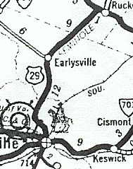
One of the earliest segments of the Seminole Trail andUS 29 to be realigned was a nearly 20 mile route that ran north from Charlottesville. The route traveled through Earlysville over the North Fork of the Rivanna River and met up with US 33 one mile west of Ruckersville then headed east before turning north and onto the current alignment. (See 1932 VDOH map at left) this route was changed in 1933 to follow what is US 29's current alignment. Today, you can follow this route exclusively by way of Secondary Route 743.
Along Route 743 in Advance Mills, the road crossed the North Fork of the Rivanna River over a narrow, wooden, plank deck, through truss bridge. The nineteenth-century bridge was moved to this location in 1943. It replaced a washed out wooden bridge that carried the Seminole Trail a decade earlier. The two span bridge contained one Pratt truss and one pony truss. The original home for this bridge is not known. In 2006, the bridge was closed for two months when a routine inspection discovered damage to numerous structural elements. When I traced the route in July 2009, the bridge and crossing over the Rivanna was closed. A new bridge has since replaced the crossing.
 Culpeper - Jeffersonton - Warrenton:
As mentioned in the introduction of this article, the auto trail appears to have ran on an alignment from Culpeper to Warrenton through Jeffersonton. Today, that route can easily be traced from Culpeper via VA 229 and then a left onto Secondary Route 802 (Springs Road) into Warrenton. SR 802 is also a Virginia Byway. In Jeffersonton, SR 802 intersects SR 621. The signs at the rural crossroads are well marked.
Sources & Links:
The Seminole Trail was named by an act of the Virginia General Assembly on February 16, 1928. Today, US 29 is known as the Seminole Trail from Danville to Warrenton.
Same Road; New Numbers, Early 1920's-1932:
 |
| Courtesy Mike Roberson |
Could the Seminole Trail have followed the original VA 28 from Culpeper to Warrenton via Jeffersonton? Well, looking at the 1942 State Map at right, that possibility does exist. Old VA 28, which in 1942 was VA 29 (totally unrelated to US 29), was the route of the trail from Charlottesville to Culpeper. If this is correct, the original Seminole Trail follows modern-day VA 229 (which replaced VA 29 in the late 1940s) to near Jeffersonton. The Trail would then follow Secondary Route 802 from VA 229 to Warrenton. It is unclear at this time whether or not the Seminole Trail did follow this route; or if it did follow what was then VA 32. In modern times, the current US 29 route from Culpeper to Warrenton is designated as the Seminole Trail.
With the birth of the US Highway System in 1926, new numbers were added to the trail. US 170 would share the road with VA 14 into Lynchburg. Later in 1929, US 15 would take over VA 32 from Culpeper to Warrenton. By the early 1930's, VA 14 would leave also. During this ten plus year period, changes were made to the alignments as roads were improved and straightened.
One Number for One Trail:
Uniformity came to the Seminole Trail in 1932, when US 29 which had terminated in Kings Mountain, North Carolina was extended along then US 170 into Lynchburg. US 29 didn't stop there, as it continued into Charlottesville along VA 18 and towards Culpeper on VA 28. As a result, both VA 18 and VA 28 were no longer signed on the trail. Two years later, US 29 would be extended through Virginia and into the nation's capital along US 15 and US 211.
Why call it 'Seminole Trail'?:

Other Designations:
US 29 is also known by other names in Virginia. From Warrenton to Washington, DC, US 29 is part of the Lee Highway, named after former Confederate General Robert E. Lee. Of course in various towns and counties, US 29 may have a different name than 'Seminole Trail'. It also shares the James Madison Highway designation with US 15 in Northern Virginia, and the entire route is named in honor of the 29th Infantry Division.
Danville:

However as early as the mid 1930s, attempts were made to divert through traffic from the West End. A short-lived Alternate US 29 existed from about 1932-1942, running along Worsham Street and tying into Main on the north shore of the Dan River. A second and longer lasting Alternate route was posted in 1942 and stayed to the west of town. It followed Memorial Drive, crossed the Dan west of downtown, and followed north on Piney Forest Road until returning to US 29 near Blairs. In 1971, this route was redesignated Bypass US 29 and the original US 29 became known as Business US 29.

There remains some slight highway upgrades needed to the US 29 freeway bypass of Danville. Just north and east of its junction with US 58 at the State Line, there had a been a series of at-grade intersections. Slowly, the grade crossings have been removed - and to be replaced with future interchange. One such instance occurs at Elizabeth Street. Stub ramps for the future interchange are in place, but there are currently no plans to improve the intersection to a full diamond interchange.
Blairs to Lynchburg:
US 29 continues northward as the transition from the Southern Virginia Piedmont to the foothills of the Appalachian Mountains begins. US 29 is a four lane ribbon of highway winding through the countryside. The mainline no longer visits towns like Chatham and the numerous churches there. Nor does it visit the downtowns of Gretna, Hurt, or Altavista. However, in between these small towns, the rural charm of South Central Virginia continues to be showcased. In the upcoming years, many changes may occur to the US 29 landscape. The Virginia Department of Transportation US 29 Corridor Study has suggested the building of a US 29 freeway throughout this segment. This freeway would include the current existing bypasses of Chatham, Gretna, and Hurt-Altavista. These existing bypasses and interchanges would be upgraded to modern standards. The rest of the freeway would be built on a new alignment, replacing the four lane road that in some cases was widened as recently as the mid-1970s.
The Town of Chatham is known for its 'Old South' charm and numerous Victorian Era homes. It is a small town of 1300, and the small central area doesn't seem to miss the traffic speeding by on the bypass built to the east in 1965. Business US 29, the old route through town, is lined with storefronts, a fabulous courthouse built in 1853, and many beautiful and architecturally stunning homes. Business US 29 rides through Chatham on Main Street, and on the north end of town there is a wide sweeping curve as you exit Chatham. This curve is a result of a successful petition in 1832 by Dr. Robert Coles, whom the homestead was built nearby. "He wanted his new house to be situated in a grove of oak trees, which, inconveniently, was the location of the main road north from the town." His petition proved successful and what is now Main Street was moved several yards to the west.
 |
| Welcome to Gretna! |
Gretna would be bypassed a decade later in 1975. Visitors entering Gretna are greeted with the slogan: "Town of Gretna. 'Ain't No Big Thing, But It's Growing.' (see right photo) Gretna's strong ties to the local agricultural community earned it a depot on the Virginia Midland Railroad which was known as Franklin Junction in 1876. Franklin Junction would later become Gretna.
The next bypass on US 29 is of two towns. The two Staunton River towns of Hurt, on the South shore, and Altavista, on the North shore, were bypassed in 1974. Both towns are relatively young compared to the rest of the state. Altavista, the larger of the two, was incorporated in 1912. Hurt, although settled via a land grant to Benjamin Clements in 1741, was incorporated 1967, three years after the death of John L. Hurt, Jr. A highlight of Altavista is the 'First Saturday Trade Lot' an over 50-year old tradition where residents sell and trade numerous goods.
 |
| 1927 Seminole Trail bridge over the Otter River. (Mike Roberson) |
Just beyond the north end of the Altavista Bypass is a hidden treasure of the old highway. Along what is now Secondary Route 712 sits a vintage 1927 truss bridge over the Otter River. The bridge, which carried the Seminole Trail and US 29 until 1953, is still serviceable today.
Lynchburg:
Lynchburg is known as "The City of Seven Hills," and it is here where US 29 goes from a rural piedmont highway to hugging the eastern slopes of the Blue Ridge Mountains. US 29 has a colorful past in the Lynchburg area. Now, US 29 has a new chapter added to its Lynchburg story, the Madison Heights Bypass has moved US 29 east of the city and off the 1960s era Lynchburg Expressway. This along with the upgrading of the Danville Bypass are the first two modernization projects for US 29 that may lead to an Interstate designation. Many residents of Lynchburg had voiced their concern that the new highway will take away from traffic from downtown Lynchburg.

 |
| US 29 along its new alignment with US 460 in Lynchburg. (Bill Manning) |
The proposed South Lynchburg Bypass would carry US 29 on a new alignment from US 460 south and westwards to where VA 24 meets US 29. The state filed a letter of intent for an Environmental Impact Study with the EPA in February of 2002. The study consists of "...combination of improvements including the construction of a four-lane divided limited access highway on new location and the improvement of existing facilities. Where alternatives overlap existing Route 460, a six-to-eight lane typical section on Route 460 would be necessary. The length of the proposed improvement ranges from 12.8 miles to 21 miles depending upon the alternative being considered." If completed, the South Lynchburg Bypass will take US 29 traffic away from a very congested route that currently consists of five traffic signals between VA 24 and US 460. South of VA 24 to the NC line there is only one traffic signal on US 29.
Madison Heights to Charlottesville:

The town of Amherst was bypassed by the four-lane US 29 by 1972. The county seat of the county that shares its name was originally named Five Oaks. (1) Like many of the other towns and cities that US 29 now bypasses, the original US 29 routing, now Business Route 29, through Amherst is Main Street. The old route meets US 60 in Downtown Amherst and this intersection features a traffic circle. An interesting event that is sponsored by the Amherst County Museum and Historical Society is the "Get to Know Your County Tour", that are centered on local roads or topics. The tours visits local villages, farms, plus various natural and industrial features.
Between Amherst and Lovingston, US 29 had followed what is now VA 151 to Piney River and then East on VA 56 to Colleen. This was the original routing of the Seminole Trail/US 29 until the late 1940s when US 29 moved to its current alignment.
Lovingston and Lovingston Bypass:
 |
| Lovingston, VA (Adam Froehlig) |
Charlottesville:
The City of Charlottesville is one of the most vibrant, colorful, and enjoyable cities in all of Virginia. Anchored by the University of Virginia, Charlottesville is full of history, beauty, and charm. The Downtown Mall, formerly Main Street, has been one of the most successful pedestrian malls in the country. Home of over 120 shops and 30 restaurants - many of which include outdoor dining - the Mall mixes in historical architecture, specialty shops, live entertainment, and a festive atmosphere.
For over 30 years, US 29 ran through the heart of Charlottesville and the University of Virginia. This changed in the mid-1960s, when a three and a half mile bypass opened to the west of town. Part of this bypass was routed on the existing US 250 bypass. The 250 bypass was built in the 1950s running east-west traffic on the north end of the city. The former routing of US 29, which ran on Fontaine Ave., Jefferson Park Ave. and Emmet St., became US 29 Business.
At Emmet St., US 29 leaves the bypass and returns briefly to its original path. This interchange consisting of the US 29/250 Bypass, US 29 Business (Emmet St.) and US 29 North is very tight and heavily congested. It is a partial cloverleaf and during rush hours or on football Saturdays navigation of this interchange and the approaches can be very tense. North of the interchange, US 29 is the key arterial serving the thickening northern suburbs of Charlottesville. Seeing this as a problem, VDOT, in the late 1990s, widened US 29 from four to six or eight lanes for approximately five miles from the bypass to near the Rivanna River.
Just north of US 250, the original Semionle Trail leaves US 29 at Secondary Route 743/Hydraulic Road. Route 743 parallels US 29 to the east until Ruckersville. This is an original alignment of US 29 and the Seminole Trail until 1933 when both designations were moved to today's routing.
Charlottesville to Warrenton:

Like many of the towns that received a US 29 bypass, the town of Culpeper (1972) and the town of Remington (1974) were the sites of two new alignments for US 29 in the early 1970s. In Culpeper, US Route 15 joins Highway 29 and both will continue along the same path until Gainesville. The Remington Bypass like Madison and Lonvingston does not have any interchanges but is served by Business Routes 15 and 29. The Remington Bypass is home to a few at grade intersections that can be improved into interchanges in the future.

Old Alignments of the Seminole Trail and US 29:
Until the late 1940s, US 29 from Amherst to Colleen followed a more indirect route by way of the small rail village of Piney River. This route follows modern day VA 151 to just north of Pine River where it bears right onto VA 56. The old route is a quick 13 mile (approximately 20 minute) detour from the modern highway that replaced it.
 |
| Courtesy Mike Roberson |
One of the earliest segments of the Seminole Trail andUS 29 to be realigned was a nearly 20 mile route that ran north from Charlottesville. The route traveled through Earlysville over the North Fork of the Rivanna River and met up with US 33 one mile west of Ruckersville then headed east before turning north and onto the current alignment. (See 1932 VDOH map at left) this route was changed in 1933 to follow what is US 29's current alignment. Today, you can follow this route exclusively by way of Secondary Route 743.
Along Route 743 in Advance Mills, the road crossed the North Fork of the Rivanna River over a narrow, wooden, plank deck, through truss bridge. The nineteenth-century bridge was moved to this location in 1943. It replaced a washed out wooden bridge that carried the Seminole Trail a decade earlier. The two span bridge contained one Pratt truss and one pony truss. The original home for this bridge is not known. In 2006, the bridge was closed for two months when a routine inspection discovered damage to numerous structural elements. When I traced the route in July 2009, the bridge and crossing over the Rivanna was closed. A new bridge has since replaced the crossing.
 |
| Former US 29 bridge over the Rivanna River (Mike Roberson) |
As mentioned in the introduction of this article, the auto trail appears to have ran on an alignment from Culpeper to Warrenton through Jeffersonton. Today, that route can easily be traced from Culpeper via VA 229 and then a left onto Secondary Route 802 (Springs Road) into Warrenton. SR 802 is also a Virginia Byway. In Jeffersonton, SR 802 intersects SR 621. The signs at the rural crossroads are well marked.
Sources & Links:
- US 29 @ The Virginia Highways Project ---Mike Roberson & Adam Froehlig
- Mike Roberson
- Adam Froehlig
- Bill Manning
Comments
The letter from the FHWA in 2014 that killed the bypass should be overturned by President Trump.
The South Lynchburg Bypass need to be built.
Right now the bypass is not on the books.