
Small Towns of Virginia Series - Pound

Downtown Pound, Virginia
Just south of the Kentucky State Line along US 23 is the Town of Pound.  This Mountain Empire town of nearly 1,000 is a sample of many of the small towns in this region - tucked away within the folds of the numerous hills and mountains of the area and not a straight road to be found.

The Pound Hardware & Furniture Company building is now home to a hodgepodge of different shops.
Pound sits along Virginia's Crooked Road - a meandering journey through Southwest Virginia highlighting and celebrating the regions connection to Americana and Bluegrass Music.  Pound celebrates its piece of Bluegrass Heritage 7:00 pm every Thursday night at the Pound Town Hall Building.  "Pickin' in the Pound" features local bluegrass musicians and southwest Virginia hospitality.

Until 2011, Pound was home to the Pound High School Wildcats.  That year, Wise County consolidated Pound HS with Wise's J.J. Kelly High School to form Central High School in Norton.  The new Central High School would open in 2013.  From my visit there in 2008, Pound was very proud of their high school.

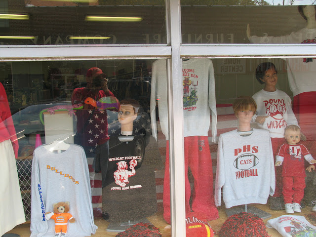
This local store displays Pound High School Wildcat Pride

Pound sits along the Pound River and is served by US 23 and Virginia Route 83.  The planned Coalfields Expressway - which will run from Beckley, WV southwest to Pound - will have its southern terminus here.  There is no timetable for completion for this road.

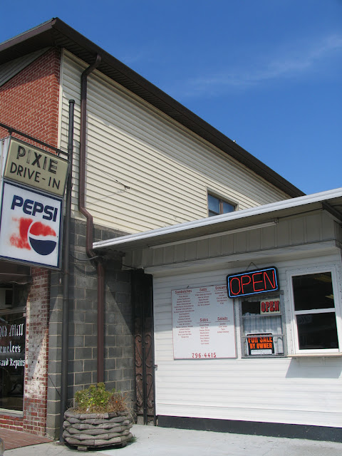
The Pixie Drive-In was for sale by owner in 2008; however, it is still there and under new ownership.
Site Navigation:

Comments

Popular posts from this blog

Old River Lock & Control Structure (Lettsworth, LA)

  The Old River Control Structure (ORCS) and its connecting satellite facilities combine to form one of the most impressive flood control complexes in North America. Located along the west bank of the Mississippi River near the confluence with the Red River and Atchafalaya River nearby, this structure system was fundamentally made possible by the Flood Control Act of 1928 that was passed by the United States Congress in the aftermath of the Great Mississippi River Flood of 1927 however a second, less obvious motivation influenced the construction here. The Mississippi River’s channel has gradually elongated and meandered in the area over the centuries, creating new oxbows and sandbars that made navigation of the river challenging and time-consuming through the steamboat era of the 1800s. This treacherous area of the river known as “Turnbull’s Bend” was where the mouth of the Red River was located that the upriver end of the bend and the Atchafalaya River, then effectively an outflow

Memphis & Arkansas Bridge (Memphis, TN)

  Like the expansion of the railroads the previous century, the modernization of the country’s highway infrastructure in the early and mid 20th Century required the construction of new landmark bridges along the lower Mississippi River (and nation-wide for that matter) that would facilitate the expected growth in overall traffic demand in ensuing decades. While this new movement had been anticipated to some extent in the Memphis area with the design of the Harahan Bridge, neither it nor its neighbor the older Frisco Bridge were capable of accommodating the sharp rise in the popularity and demand of the automobile as a mode of cross-river transportation during the Great Depression. As was the case 30 years prior, the solution in the 1940s was to construct a new bridge in the same general location as its predecessors, only this time the bridge would be the first built exclusively for vehicle traffic. This bridge, the Memphis & Arkansas Bridge, was completed in 1949 and was the third

California State Route 203 the proposed Minaret Summit Highway

California State Route 203 is an approximately nine-mile State Highway located near Mammoth Lakes in the Sierra Nevada Mountains of Mono County.  California State Route 203 as presently configured begins at US Route 395, passes through Mammoth Lakes and terminates at the Madera County line at Minaret Summit.  What is now California State Route 203 was added to the State Highway System in 1933 as Legislative Route Number 112.  The original Mammoth Lakes State Highway ended at Lake Mary near the site of Old Mammoth and was renumbered to California State Route 203 in 1964.  The modern alignment of the highway to Minaret Summit was adopted during 1967.   The corridor of Minaret Summit and Mammoth Pass have been subject to numerous proposed Trans-Sierra Highways.  The first corridor was proposed over Mammoth Pass following a Southern Pacific Railroad survey in 1901.  In 1931 a corridor between the Minarets Wilderness and High Sierra Peaks Wilderness was reserved by the Forest Service for po