New Windsor Cantonment State Historic Site - New Windsor, New York

The Hudson Valley holds an important part of the history of the American Revolution. For instance, the Hudson River at West Point was considered one of the most important strategic locations during the Revolutionary War. Not far upstream in New Windsor is one of the locations of the final days of the American Revolution, an encampment where George Washington and his troops wintered from October 1782 to June 1783, the New Windsor Cantonment.


A year after the decisive American victory over the British in Yorktown, Virginia in 1781, George Washington moved a large part of his army to New Windsor for winter quarters or in other words, a cantonment. Although the American army was better housed, fed and clothed than any other time during the Revolutionary War, life at the New Windsor Cantonment was still quite difficult. At the cantonment in New Windsor, some 7000 troops built log huts for shelter, drilled and kept ready for a possible spring campaign if peace negotiations in France were not successful. Meanwhile, grievances over pensions, land and back pay threatened to have soldiers erupt in rebellion. Following the news of the Treaty of Paris, Washington issued cease fire orders, which became effective April 19, 1783, bringing the eight year war to an end and the army was peacefully furloughed back to their homes and communities.

High ranking officers in the American army, including Major General Horatio Gates and Major General Henry Knox, were quartered in nearby private homes. George Washington made his headquarters in the Jonathan Hasbrouck house in Newburgh, and that house is now known as Washington's Headquarters State Historic Site.

Today, the New Windsor Cantonment State Historic Site preserves 120 acres of the original 1600 acre encampment, where soldiers transformed the acreage of forests and meadows into the the military encampment where they spent the final months of the Revolution. A visit to the cantonment will allow you to see replicas and foundations of buildings constructed by soldiers, monuments, demonstrations of military drills and daily cantonment life. There are sites related to the cantonment found on both sides of NY Route 300, which may locally be known as Temple Hill Road, a nod to the Temple of Virtue that was built on the site of the encampment. On the grounds of the New Windsor Cantonment State Historic Site, you can also find the National Purple Heart Hall of Honor, as it was George Washington himself who awarded badges of merit, a predecessor of the Purple Heart, in those waning days of the Revolution.

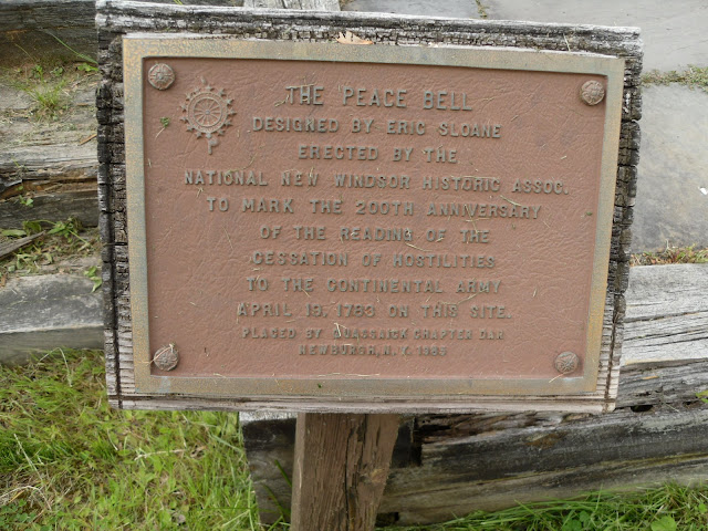
The Peace Bell, which was constructed to commemorate the cessation of hostilities at the end of the American Revolution.


Encampment cabins, or hut sites.

Some of the huts you will encounter on site were for the 4th and 7th Massachusetts Regiments.

Historical marker noting the hut sites at the winter encampment. As you can see, many stone foundations of the huts remain.
Some foundations of the huts.


Monument dedicated to the last cantonment of the American Revolution.

Cantonment cemetery.

Replicas of cabins built during the encampment period can be found around the historic site.


Soldier's hut foundation.
The Temple of Virtue, the most famous building in the cantonment. In December 1782, at the suggestion of the Reverend Israel Evans, General Washington ordered the troops to construct a large building that would serve as a chapel for Sunday services. The resulting Temple of Virtue, also called the Public Building, was 110 feet in length by 30 feet in width. The building was used also for court martial hearings, the encampment's commissary, quartermaster activities and officers’ functions.

A great number of events happened at the Temple of Virtue. On March 15, 1783, a challenge to General Washington and the Continental Congress, now known as the Newburgh Addresses, was countered by Washington at a meeting held in the Temple of Virtue. A month later, When news of the peace treaty and Congress’ “Proclamation of the Cessation of Hostilities” happened in April 1783, this enabled Washington to issue cease fire orders. As a result, a copy of the proclamation was posted on the door of the Temple of Virtue.


The outside of the Temple of Virtue.
George Washington felt it was important to honor the men who served in the Army during the Revolutionary War, and it was at the Temple of Virtue, he was able to gather stories of enlisted soldiers and select candidates to be awarded the Badge of Military Merit, which is considered to be a predecessor of today's Purple Heart.
Because of this, there is a now a museum called the National Purple Heart Hall of Honor at the New Windsor Cantonment.

The National Purple Heart Hall of Honor visitor's center and museum.


Remembering those soldiers killed or wounded in action during American military campaigns.


How to Get There:


Sources and Links:
Vintage Hudson Valley - American Revolution Sites and Museums
A Revolutionary Day - New Windsor Cantonment
ScholarWorks at Grand Valley State University - George Washington and the Temple of Virtue
New York State Parks, Recreation and Historic Preservation - New Windsor Cantonment State Historic Site


Update Log:
March 10, 2019 - Published article to Unlocking New York.
October 12, 2021 - Transferred article from Unlocking New York to Gribblenation.

Comments

Popular posts from this blog

I-40 rockslide uncovers old debates on highway

The Asheville Citizen-Times continues to do a great job covering all the angles of the Interstate 40 Haywood County rock slide. An article in Sunday's edition provides a strong historical perspective on how the Pigeon River routing of Interstate 40 came about. And perhaps most strikingly, in an article that ran just prior to the highway's opening in the fall of 1968, how engineers from both Tennessee and North Carolina warned "...that slides would probably be a major problem along the route for many years." On February 12, 1969, not long after the Interstate opened, the first rock slide that would close I-40 occurred. Like many other Interstates within North Carolina, Interstate 40 through the mountains has a history prior to formation of the Interstate Highway System and was also a heated political battle between local communities. The discussion for a road that would eventually become Interstate 40 dates back to the 1940's as the idea for interregional high

Mines Road

Mines Road is an approximately twenty-eight-mile highway located in the rural parts of the Diablo Range east of the San Francisco Bay Area.  Mines Road begins in San Antonio Valley in Santa Clara County and terminates at Tesla Road near Livermore of Alameda County.  The highway essentially is a modern overlay of the 1840s Mexican haul trail up Arroyo Mocho known as La Vereda del Monte.  The modern corridor of Mines Road took shape in the early twentieth century following development of San Antonio Valley amid a magnesite mining boom.  Part 1; the history of Mines Road Modern Mines Road partially overlays the historic corridor used by La Vereda del Monte (Mountain Trail).  La Vereda del Monte was part of a remote overland route through the Diablo Range primarily used to drive cattle from Alta California to Sonora.  The trail was most heavily used during the latter days of Alta California during the 1840s. La Vereda del Monte originated at Point of Timber between modern day Byron and Bre

Former California State Route 41 past Bates Station

When California State Route 41 was commissioned during August 1934 it was aligned along the then existing Fresno-Yosemite Road north of the San Joaquin River.  Within the Sierra Nevada foothills of Madera County, the original highway alignment ran past Bates Station via what is now Madera County Road 209, part of eastern Road 406 and Road 207.   Bates Station was a stage station plotted during the early 1880s at what was the intersection of the Coarsegold Road and Stockton-Los Angeles Road.   The modern alignment bypassing Bates Station to the east would be reopened to traffic during late 1939.   Part 1; the history of California State Route 41 past Bates Station Bates Station was featured as one of the many 1875-1899 Madera County era towns in the May 21, 1968, Madera Tribune .  Post Office Service at Bates Station is noted to have been established on November 23, 1883 and ran continuously until October 31, 1903.  The postal name was sourced from Bates Station owner/operator George Ba