
John Boyd Thacher State Park - Indian Ladder Trail

Located approximately 15 miles southwest of Albany along NY State Route 157, John Boyd Thacher State Park offers some of the most expansive and panoramic views in the Capital Region.  Standing on the top of the Helderberg Escarpment, the over 100 year old state park is home to numerous hiking trails, rock climbing, camping and many outdoor picnic and recreation facilities.
The Albany Skyline can easily be seen from the Indian Ladder Trail.
The most popular hiking trail within the park is the Indian Ladder Trail.  A 2.5 mile journey along the limestone cliffs is an excellent quick hike that offers amazing views and a few surprises along the way.

At an elevation of nearly 1200 feet above sea level, the escarpment sits nearly 800 feet over the Hudson Valley.  Helderberg in Dutch means "Clear Mountain"; and on a clear day, the views from the park and trail are amazing.  In addition to panoramic views of the valley and the Albany skyline, the Taconic, Adirondack, Massachusetts' Berkshire, and Vermont's Green Mountains can easily be seen.

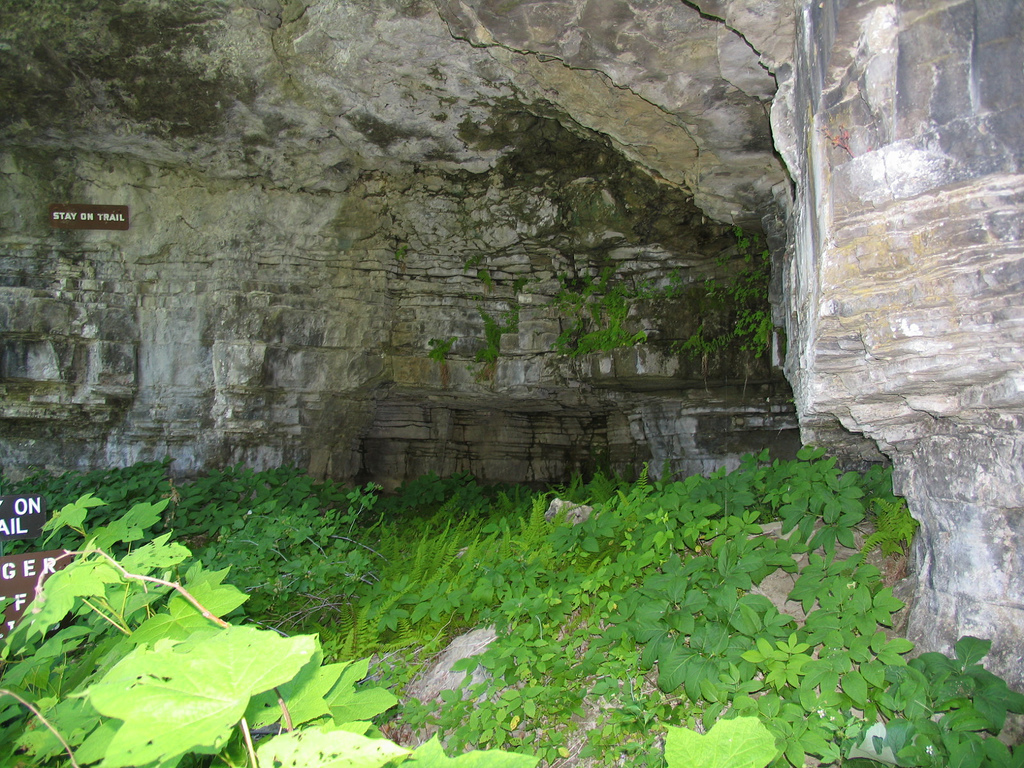
Examples of the many mini-caves that can be found along the Indian Ladder Trail


Since the escarpment is made of limestone, there are numerous small caves along the Indian Ladder Trail.  If you have time, try to locate various fossils within the limestone rocks.  The escarpment and specifically the park is well known for fossils embedded within the limestone.

Minelot Falls
Minelot Falls is another attraction along the Indian Ladder Trail.  The trail passes under the 116 foot waterfall.  Unfortunately, when I visited the falls were not as strong as they could be.

In recent years, the park and trail has faced various closures or attempted in closures.  In 2010, as a result of a state budget deficit, then Governor David Patterson attempted to close the park as a cost cutting measure.  As a result of public outcry and local efforts, the park remained open.


The Indian Ladder Trail was closed for nearly a year from July 2017 through June 2018 as a result of rocks from the escarpment falling and landing on a visitor.  As a result of thousands of years of erosion there are many loose rocks along the cliffs of the escarpment that can pose a danger to hikers.  The state conducted a scaling and clean up project that removed numerous loose rocks from the cliffs along the trail.

All photos taken by post author - July 3, 2005

Getting There:


Further Reading:

Comments

Popular posts from this blog

North Carolina Continues to Move Forward with Rail

2023 and the first half of 2024 have seen continued growth in North Carolina's passenger rail system.  From increased daily trains from Raleigh to Charlotte, federal funds for studying additional corridors, and receiving a historic grant to begin the construction of high-speed rail between Raleigh and Richmond, the last 18 months have been a flurry of activity at NCDOT's Rail Division.  And that's just the tip of the iceberg. As ridership and routes increase - the engine of North Carolina passenger rail trains will become a more common sight. (Adam Prince) Increased Passenger Train Service: On July 10, 2023, a fourth Piedmont round-trip rail service between Raleigh and Charlotte commenced.  The four Piedmont trains plus the daily Carolinian (to Washington, DC, and New York) bring the total of trains serving the two cities daily to five. The current daily Piedmont and Carolinian schedule between Charlotte and Raleigh (NCDOT) The result was over 641,000 passengers utilized pa

US Route 101 in Benbow, Garberville and Redway

The communities of Benbow, Garberville and Redway can all be found along US Route 101 within southern Humboldt County.  The former surface alignment of US Route 101 in Garberville and Redway once crossed the Garberville Bluffs along what is now Redwood Drive via a corridor constructed as part of the Redwood Highway during the 1910s.  US Route 101 through Benbow, Garberville and Redway was modernized by 1935.  US Route 101 would eventually be upgraded to freeway standards in Benbow, Garberville and Redway by extension of the Redwood Freeway during 1966-68.  As the cover photo the original grade of US Route 101 and the Redwood Highway can be seen at the Garberville Bluffs during 1934.  US Route 101 can be seen in the communities of Benbow, Garberville and Redway on the 1935 Division of Highways Map of Humboldt County .   The history of US Route 101 in Benbow, Garberville and Redway Benbow, Garberville and Redway lie on the banks of the South Fork Eel River of southern Humboldt County.  D

The Midway Palm and Pine of US Route 99

Along modern day California State Route 99 south of Avenue 11 just outside the City limits of Madera one can find the Midway Palm and Pine in the center median of the freeway.  The Midway Palm and Pine denotes the halfway point between the Mexican Border and Oregon State Line on what was US Route 99.  The Midway Palm is intended to represent Southern California whereas the Midway Pine is intended to represent Northern California.  Pictured above the Midway Palm and Pine can be seen from the northbound lanes of the California State Route 99 Freeway.   This blog is part of the larger Gribblenation US Route 99 Page.  For more information pertaining to the other various segments of US Route 99 and it's three-digit child routes check out the link the below. Gribblenation US Route 99 Page The history of the Midway Palm and Pine The true timeframe for when the Midway Palm and Pine (originally a Deadora Cedar Tree) were planted is unknown.  In fact, the origin of the Midway Palm and Pine w