While in the St. Petersburg area I wanted to try a roadway that I never traveled on previously. Being a fan of old military fortifications Florida State Road 679 over the south Pinellas Bayway seemed to the ticket.

FL 679 is part of the Pinellas Bayway System which also consists of FL 682. The Pinellas Bayway system a series of roadways that bridge many of the Keys located at the mouth of Tampa Bay which were completed in 1962. FL 682 was originally designated as FL A19A and is a 3.7 mile State Road from US 19/I-275 in St. Petersburg west to FL 699 in St. Pete Beach. FL 679 was originally designated as FL 693 and is a 4.8 mile State Road from FL 682 south to Fort De Soto Park. The designations of the Pinellas Bayway system were changed to their current designations in the 1980s. Both FL 682 and FL 679 each have one tolled bridge.
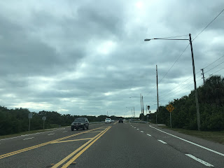
FL 682 meets the north terminus of FL 679 on Isla Del Sol immediately west of the FDOT toll facility. Fort De Soto Park is prominently signed directing traffic on FL 679 southward.


FL 679 is signed as the "P.E. "Gene" Carpenter Memorial Highway."

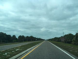
FL 679 follows a causeway south to a draw span over the Gulf Intercoastal Waterway to Tierra Verde which is located on Pine Key, Cabbage Key and Cunningham Ham Key.


Fort De Soto displays the 1890-M1 mortars it was known for during it's service period.


Much of the lower level of Fort De Soto appears generally as how it would during it's service days. Apparently there was substantial plant overgrowth that was encroaching onto the fort which was recently removed.


There is a small walk way over the top of Fort De Soto. Off in the distance St. Pete Beach can be seen to the north. Looking eastward the Sunshine Skyway Bridge can be seen over Tampa Bay.


On the Gulf side of Fort De Soto the ruins of Battery Bigelow can be seen in the waters.


Egmont Key can be seen from Fort De Soto along with the 1858 Lighthouse. The 1858 lighthouse replaced 1847 structure which blew down in the 1848 Tampa Bay Hurricane. The 1858 Egmont Key Lighthouse is the oldest active such structure in the Tampa Bay area.


Egmont Key is a great place to watch freight ships enter Tampa Bay and spot a stray dolphin or two.


FL 679 is part of the Pinellas Bayway System which also consists of FL 682. The Pinellas Bayway system a series of roadways that bridge many of the Keys located at the mouth of Tampa Bay which were completed in 1962. FL 682 was originally designated as FL A19A and is a 3.7 mile State Road from US 19/I-275 in St. Petersburg west to FL 699 in St. Pete Beach. FL 679 was originally designated as FL 693 and is a 4.8 mile State Road from FL 682 south to Fort De Soto Park. The designations of the Pinellas Bayway system were changed to their current designations in the 1980s. Both FL 682 and FL 679 each have one tolled bridge.
FL 682 meets the north terminus of FL 679 on Isla Del Sol immediately west of the FDOT toll facility. Fort De Soto Park is prominently signed directing traffic on FL 679 southward.


FL 679 is signed as the "P.E. "Gene" Carpenter Memorial Highway."

FL 679 follows a causeway south to a draw span over the Gulf Intercoastal Waterway to Tierra Verde which is located on Pine Key, Cabbage Key and Cunningham Ham Key.


FL 679 expands to a four-lane divided highway on Cabbage Key before descending back to conventional two-lane road on Cunningham Key.


The bridge from Cunningham Key to Madelaine Key has a $0.75 toll.


On Madelaine Key the route of FL 679 enters Fort De Soto Park. Apparently FL 679 ends at the boundary of Fort De Soto Park but wasn't always the case. FL 693 originally continued through Fort De Soto Park to the west end of Mullet Key. The original FL 699 split eastward on Mullet Key towards the original Sunshine Skyway Bridge.

The ferry to Egmont State Park is located just off the main park road in on Mullet Key shortly before Fort De Soto.

Fort De Soto was an Army fortification built between 1898 and 1900 during the onset of the Spanish-American War. Fort De Soto was largely constructed of a shell-concrete mix and featured numerous artillery batteries and 12 inch coast defense mortars. The 1890-M1 mortars housed at Fort De Soto had a range of 6.8 miles. Fort De Soto was active until 1910 but a skeleton presence by the U.S. Army remained until the mortars were removed in 1917. Fort De Soto was abandoned by 1923 and remained derelict until Pinellas County purchased Mullet Key in 1938. 1941 Mullet Key was repurchased by the Federal Government which turned into a bombing range during the duration of World War II. Pinellas County purchased Mullet Key along with several surrounding Keys in 1948 which were incorporated into Fort De Soto Park when the Pinellas Bayway opened in 1962.


Much of the lower level of Fort De Soto appears generally as how it would during it's service days. Apparently there was substantial plant overgrowth that was encroaching onto the fort which was recently removed.


There is a small walk way over the top of Fort De Soto. Off in the distance St. Pete Beach can be seen to the north. Looking eastward the Sunshine Skyway Bridge can be seen over Tampa Bay.


On the Gulf side of Fort De Soto the ruins of Battery Bigelow can be seen in the waters.


Egmont Key can be seen from Fort De Soto along with the 1858 Lighthouse. The 1858 lighthouse replaced 1847 structure which blew down in the 1848 Tampa Bay Hurricane. The 1858 Egmont Key Lighthouse is the oldest active such structure in the Tampa Bay area.


Egmont Key is a great place to watch freight ships enter Tampa Bay and spot a stray dolphin or two.


Comments