Back in 2012, I stopped in at Petrified Forest National Park on the Colorado Plateau which used to be crossed by US Route 66 in addition to Arizona State Route 63.

Petrified Forest National Park is mostly known for fossilized trees from the Late Triassic Period about 225 million years ago. Petrified Forest National Park spans much of the border along the Navajo County and Apache County line between I-40 south to US 180. Petrified Forest was set aside as a National Monument in 1906 to protect the fossils from theft and was elevated to a National Park in 1962. Given that US Route 66 ran through Petrified Forest National Park, it has become associated with the highway.
From I-40, access to the Painted Desert Visitor Center and the Park itself is fairly straightforward.

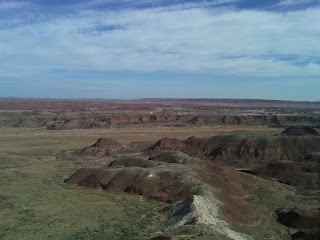
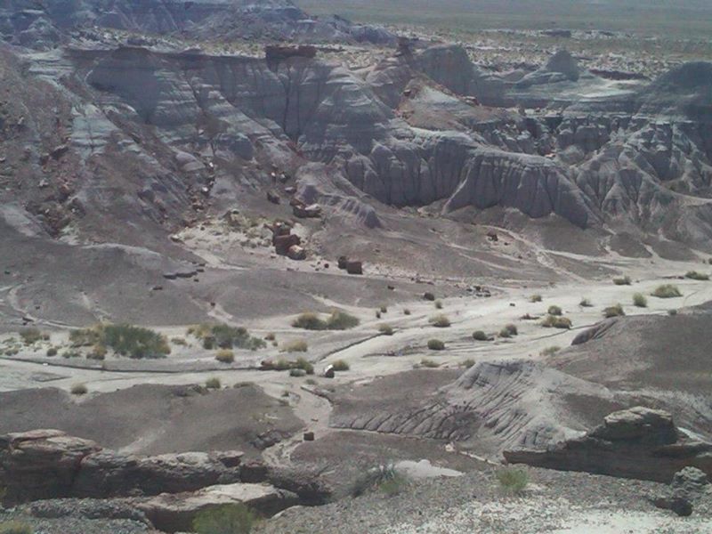
The northern annex of Petrified Forest contains several vistas of the Painted Desert. The Painted Desert consists of a series of Badlands on the Colorado Plateau running from the east rim of the Grand Canyon easterly to Petrified Forest National Park.


US Route 66 before I-40 was built used to run across the south side of the modern traffic lanes and directly through the northern annex of Petrified Forest National Park. US 66 would emerge east of the northern Petrified Forest Painted Desert Visitor Center onto Pinta Road. The alignment of US 66 is plainly visible via satellite images. The National Park Service even provided a historical marker where US 66 crossed the lanes occupied by I-40.


From the US 66 monument south to US 180 the routing of Park Road was once part of the original Arizona State Route 63. AZ 63 apparently was created in 1932 and appeared on maps under state maintenance as late as 1951. By 1956 maintenance of AZ 63 had been turned over to the National Park Service.
Arizonaroads on AZ 63
1935 Arizona State Highway Map
1951 State Highway Map
1956 Arizona State Highway Map
South of I-40 there is a series of petroglyphs that can be viewed via telescope to the west near the former Atlantic & Pacific Railroad siding of Adamana.


Formations like The Teepees, pictured below, are common in the Painted Desert. The southern annex of Petrified Forest National Park has various formations with blue and purple color hues.


To the south of The Teepees, the park road traverses by Blue Mesa which can be accessed by the Blue Mesa Scenic Road.

Blue Mesa overlooks various clusters of fossilized trees.


South of Blue Mesa the Agate Bridge forms a small fossil bridge. The Agate Bridge has been reinforced from the bottom with concrete.

South of the Agate Bridge the park road passes by the Crystal Forest.


Near the south gate of Petrified Forest is a large formation of fossilized logs known as the Rainbow Forest. The Rainbow Forest seemed to have what was the largest cluster of fossilized trees along the park road.


The Park Road presently ends just short of US 180 as the National Park boundary ends. The road continues as Petrified Forest Road about a quarter mile where it ends at US 180, AZ 63 would have never met the current designation. Originally AZ 63 may have ended at the first alignment of US 70 but I'm uncertain as it moved to the present location in 1932. AZ 63 ended at US 260 which was assigned over the previous US 70 alignment from 1932 until it was decommissioned in the 1950s.

Site Navigation:

Petrified Forest National Park is mostly known for fossilized trees from the Late Triassic Period about 225 million years ago. Petrified Forest National Park spans much of the border along the Navajo County and Apache County line between I-40 south to US 180. Petrified Forest was set aside as a National Monument in 1906 to protect the fossils from theft and was elevated to a National Park in 1962. Given that US Route 66 ran through Petrified Forest National Park, it has become associated with the highway.
From I-40, access to the Painted Desert Visitor Center and the Park itself is fairly straightforward.

The northern annex of Petrified Forest contains several vistas of the Painted Desert. The Painted Desert consists of a series of Badlands on the Colorado Plateau running from the east rim of the Grand Canyon easterly to Petrified Forest National Park.


US Route 66 before I-40 was built used to run across the south side of the modern traffic lanes and directly through the northern annex of Petrified Forest National Park. US 66 would emerge east of the northern Petrified Forest Painted Desert Visitor Center onto Pinta Road. The alignment of US 66 is plainly visible via satellite images. The National Park Service even provided a historical marker where US 66 crossed the lanes occupied by I-40.


From the US 66 monument south to US 180 the routing of Park Road was once part of the original Arizona State Route 63. AZ 63 apparently was created in 1932 and appeared on maps under state maintenance as late as 1951. By 1956 maintenance of AZ 63 had been turned over to the National Park Service.
Arizonaroads on AZ 63
1935 Arizona State Highway Map
1951 State Highway Map
1956 Arizona State Highway Map
South of I-40 there is a series of petroglyphs that can be viewed via telescope to the west near the former Atlantic & Pacific Railroad siding of Adamana.


Formations like The Teepees, pictured below, are common in the Painted Desert. The southern annex of Petrified Forest National Park has various formations with blue and purple color hues.


To the south of The Teepees, the park road traverses by Blue Mesa which can be accessed by the Blue Mesa Scenic Road.

Blue Mesa overlooks various clusters of fossilized trees.


South of Blue Mesa the Agate Bridge forms a small fossil bridge. The Agate Bridge has been reinforced from the bottom with concrete.

South of the Agate Bridge the park road passes by the Crystal Forest.


Near the south gate of Petrified Forest is a large formation of fossilized logs known as the Rainbow Forest. The Rainbow Forest seemed to have what was the largest cluster of fossilized trees along the park road.


The Park Road presently ends just short of US 180 as the National Park boundary ends. The road continues as Petrified Forest Road about a quarter mile where it ends at US 180, AZ 63 would have never met the current designation. Originally AZ 63 may have ended at the first alignment of US 70 but I'm uncertain as it moved to the present location in 1932. AZ 63 ended at US 260 which was assigned over the previous US 70 alignment from 1932 until it was decommissioned in the 1950s.

Site Navigation:
Comments