Back in 2014 I took Florida State Route 24 to it's western terminus on the Gulf of Mexico at Cedar Key located in Levy County.

From Otter Creek at US 19/98 it is an approximately 21 mile drive west to the terminus of FL 24 at Cedar Key.

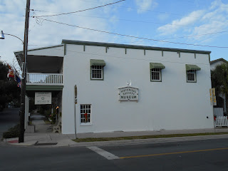
FL 24 has an unsigned terminus at D Street and 2nd Street. The real only indication that FL 24 has ended is the quality of the asphalt drops considerably suddenly as maintenance drops from FDOT to the City of Cedar Key. The terminus of FL 24 is easily located however since the Cedar Key Historical Museum is next to it.
There is also a local street sign displaying FL 24 at 2nd Street and D Street. There is also an older FDOT Wayside sign still in use despite being heavily weathered.

The really interesting part of Cedar Key is along Dock Street. Dock Street overlooks the original Cedar Key settlement on Atsena Otie Key and becomes very apparent that it was once end of the Florida Railroad.


The town site of Cedar Key dates back to 1839 when a Army Hospital was established on Astena Otie Key during the Second Seminole War. Originally Astena Otie Key was known as Depot Key when it was inhabited by the Army. Astena Otie Key was abandoned following a hurricane in 1842 but the community was resettled on Way Key and Scale Key in 1843. Despite being known as "Cedar Key" as early as 1845 by the Post Office the City of Atsena Otie was chartered in 1859.
Cedar Key was the ultimate terminus of the Florida Railroad which was completed by 1861. The Florida Railroad crossed the state westward from Fernandina Beach to Cedar Key and occupied much of what is now FL 24. The Florida Railroad was used to serve Confederate Forces during the Civil War until it was captured by the Union in 1864. In 1865 a large sawmill was constructed in Cedar Key which used the Florida Railroad to ship the lumber.
After the heyday of the Florida Railroad Cedar Key was struck by Category 3 Hurricane in 1896. The 1896 Hurricane destroyed much of what remained on Atsena Otie Key from the original settlement. A small cemetery is all that really remains on Atsena Otie Key in modern times.
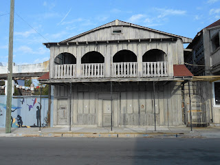
Cedar Key has a surprising amount of intact older structures, most are located along 2nd Street.


From Otter Creek at US 19/98 it is an approximately 21 mile drive west to the terminus of FL 24 at Cedar Key.

FL 24 has an unsigned terminus at D Street and 2nd Street. The real only indication that FL 24 has ended is the quality of the asphalt drops considerably suddenly as maintenance drops from FDOT to the City of Cedar Key. The terminus of FL 24 is easily located however since the Cedar Key Historical Museum is next to it.

There is also a local street sign displaying FL 24 at 2nd Street and D Street. There is also an older FDOT Wayside sign still in use despite being heavily weathered.

The really interesting part of Cedar Key is along Dock Street. Dock Street overlooks the original Cedar Key settlement on Atsena Otie Key and becomes very apparent that it was once end of the Florida Railroad.


The town site of Cedar Key dates back to 1839 when a Army Hospital was established on Astena Otie Key during the Second Seminole War. Originally Astena Otie Key was known as Depot Key when it was inhabited by the Army. Astena Otie Key was abandoned following a hurricane in 1842 but the community was resettled on Way Key and Scale Key in 1843. Despite being known as "Cedar Key" as early as 1845 by the Post Office the City of Atsena Otie was chartered in 1859.
Cedar Key was the ultimate terminus of the Florida Railroad which was completed by 1861. The Florida Railroad crossed the state westward from Fernandina Beach to Cedar Key and occupied much of what is now FL 24. The Florida Railroad was used to serve Confederate Forces during the Civil War until it was captured by the Union in 1864. In 1865 a large sawmill was constructed in Cedar Key which used the Florida Railroad to ship the lumber.
After the heyday of the Florida Railroad Cedar Key was struck by Category 3 Hurricane in 1896. The 1896 Hurricane destroyed much of what remained on Atsena Otie Key from the original settlement. A small cemetery is all that really remains on Atsena Otie Key in modern times.
Cedar Key has a surprising amount of intact older structures, most are located along 2nd Street.


Comments