
Woodrow Bean Transmountain Drive is a ten-mile component of Texas State Highway Loop 375 located in the El Paso area. Woodrow Bean Transmountain Drive connects US Route 54 west over the Franklin Mountains to Interstate 10 (also US Route 85 and US Route 180) and functions as a bypass to downtown El Paso. Woodrow Bean Transmountain Drive undoubtedly is the most notable part of the overall forty-nine-mile routing of Texas State Highway Loop 375. Woodrow Bean Transmountain Drive opened in 1970 and carries grades as high as 8%. The corridor of Woodrow Bean Transmountain Drive passes through Franklin Mountains State Park and Castner Range National Monument.

Part 1; the history of Woodrow Bean Transmountain Drive
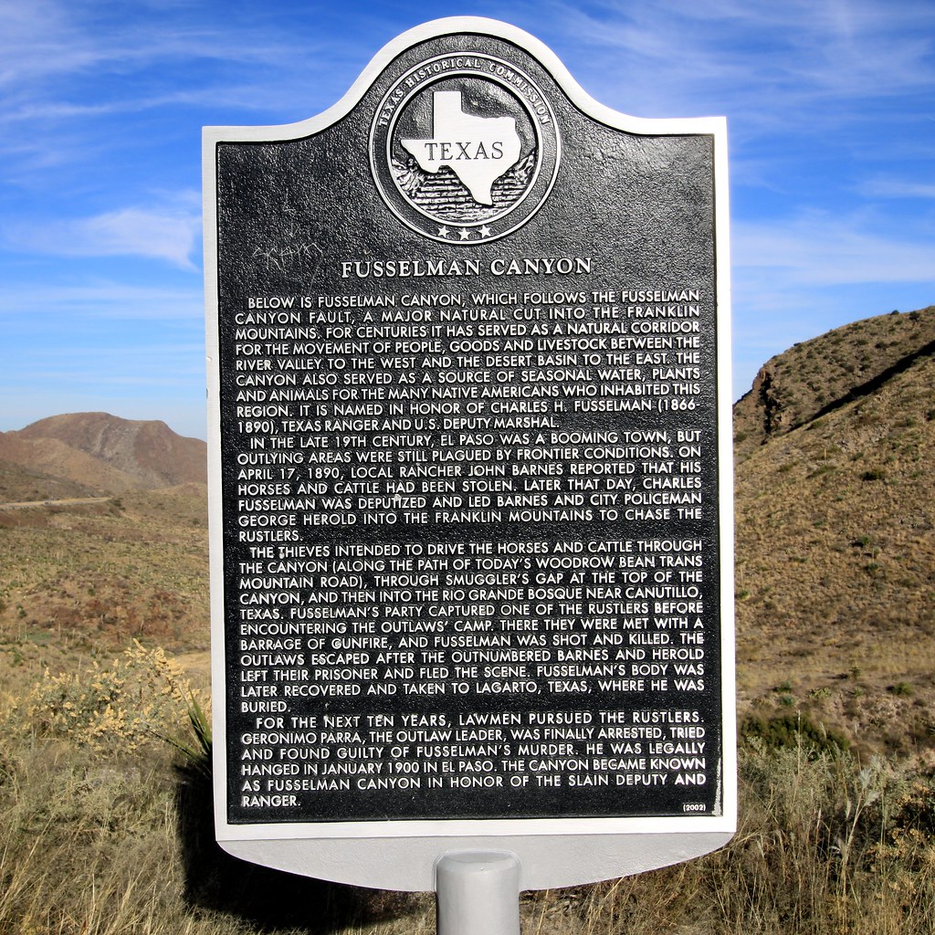
Fusselman Canyon is a natural cut which follows a fault of the same name through the Franklin Mountains. The terrain of Fusselman Canyon has made it a natural bypass of much of El Paso well before the establishment of Woodrow Bean Transmountain Drive. The canyon was named in honor former Texas Ranger and U.S. Marshall Charles Fusselman. Charles Fusselman was shot and killed trying to apprehend cattle rustlers in the Franklin Mountains during April 1890. The name "Smugglers Pass" now used by Woodrow Bean Transmountain Drive is a reference to the cattle rustling incident of April 1890.
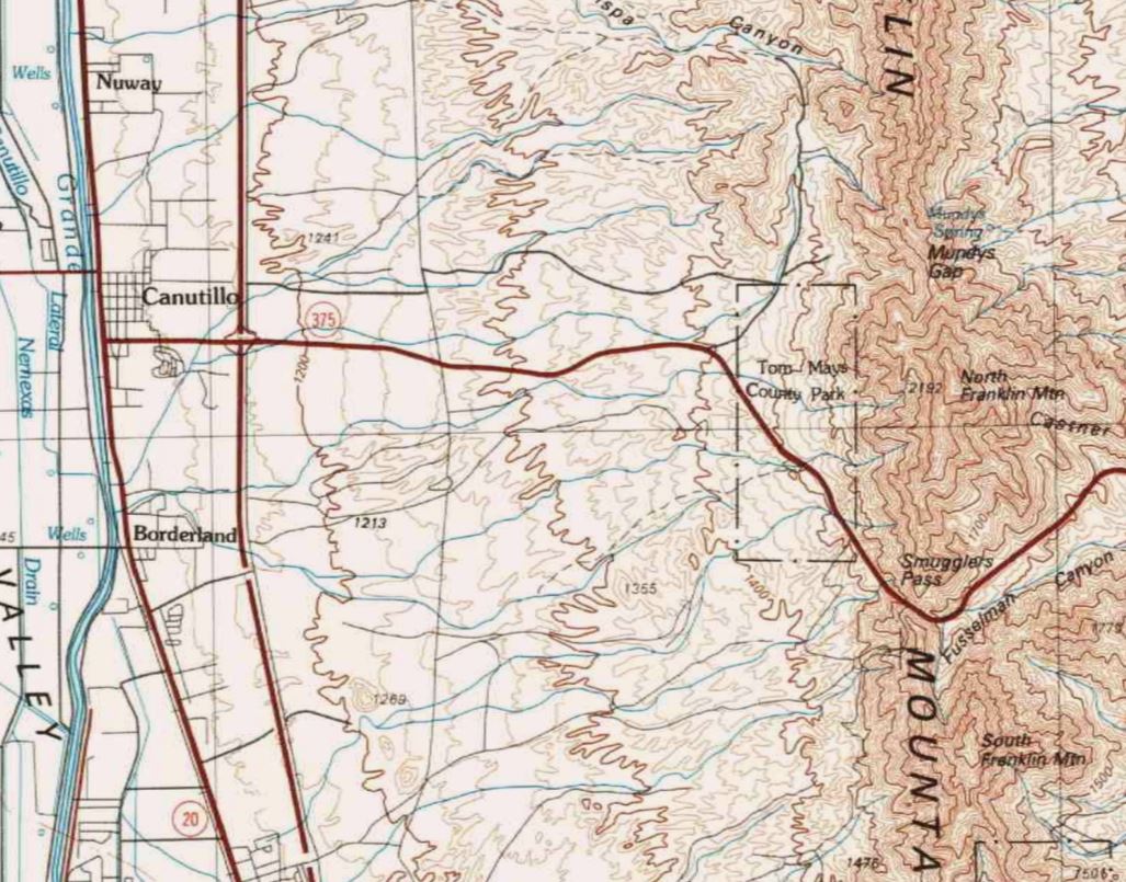
A primitive road can be seen ascending Fusselman Canyon west of Lenoria siding and the White Oaks Railroad on the 1896 United States Geological Survey Map of El Paso.

The entirety of Texas State Highway Loop 375 was designated in 1963 as part of the long term El Paso Freeway plan. The segment of Texas State Highway Loop 375 from US Route 54 bypassing downtown El Paso was planned to cross the Franklin Mountains via Fusselman Canyon and Smugglers Pass. The segment of Texas State Highway Loop 375 over the Franklin Mountains was completed during 1970 and is known as "Woodrow Bean Transmountain Drive."
Construction of Woodrow Bean Transmountain Drive involved the largest land excavation undertaken by the Texas Highway Department to that point. The namesake for the segment of highway is notable local El Paso County politician Woodrow Wilson Bean. Woodrow Bean had served as the El Paso County Judge and was a figurehead behind the push for numerous public works projects around the city of El Paso.

Woodrow Bean Transmountain Drive can be seen on the 1983 United States Geological Survey Map of El Paso as a component of Texas State Highway Loop 375. Woodrow Bean Transmountain Drive is shown connecting from Texas State Route 20 (former US Route 80) east over the Franklin Mountains to US Route 54 at Dyer Street (now US Route 54 Business). Woodrow Bean Transmountain Drive is shown connecting to Interstate 10 (then also US Route 80, US Route 85 and US Route 180) east of Texas State Highway 20.

During 2014 Woodrow Bean Transmountain Drive was fully converted to four-lane expressway standards west from Franklin Mountains State Park to Interstate 10. The project included frontage roads and two flyover ramps linking to Interstate 10.

Part 2; a photo tour of Woodrow Bean Transmountain Drive
From US Route 54 on the Patriots Freeway traffic can be access westbound Texas State Highway Loop 375/Woodrow Bean Transmountain Drive at Exit 29. Traffic departing US Route 54 is required to use Gateway Boulevard to reach Woodrow Bean Transmountain Drive.


Traffic on Woodrow Bean Transmountain Drive west of US Route 54 is advised they are entering Castner Range National Monument. Traffic is advised of 8% grades along the highway ahead.


Castner Range National Monument was established on March 21, 2023, by President Joe Biden. Presently oversight of the National Monument is administered by the United States Army. The Castner Range was in use as a munitions test range in the Franklin Mountains circa 1926-1966. The numerous "Danger, unexploded ordinance" signs along Woodrow Bean Transmountain Drive are a reference to the testing days of the Castner Range.

Westbound Woodrow Bean Transmountain Drive passes an access road to the National Border Patrol Museum and El Paso Museum of Archaeology.

Westbound Woodrow Bean Transmountain Drive climbs into the Franklin Mountains through Fusselman Canyon. Traffic is notified of a historical plaque (seen in Part 1 above) which can be accessed by both highway travel directions.


The transition point where the Woodrow Bean Transmountain Drive departs Castner Range National Monument and enters Franklin Mountain State Park has recently been fully signed.


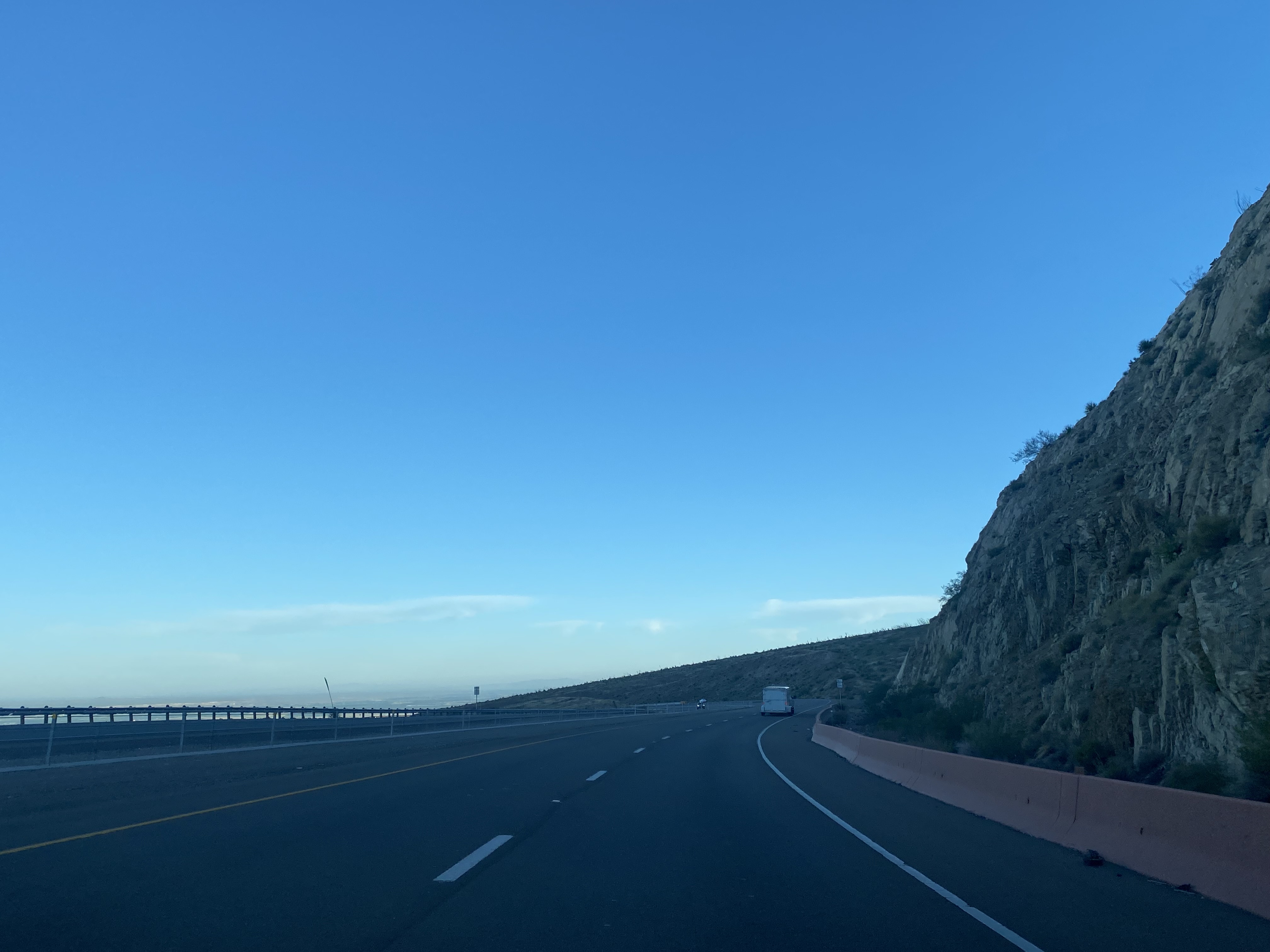
Westbound Woodrow Bean Transmountain Drive crosses the 5,280-foot-high Smugglers Pass and begins the 8% grade descent towards Interstate 10.


At the beginning of the descent towards Interstate 10 traffic can access the West Franklin Mountains Vista (photo by Adam Prince during June 2023).

Westbound Woodrow Bean Transmountain Drive intersects the access road to the Tom Mays unit of Franklin Mountains State Park.


Woodrow Bean Transmountain Drive becomes a freeway upon entering the city of El Paso. Woodrow Bean Transmountain Drive accesses Paseo Del Norte Road and Plexxar Drive at Exit 12.


Woodrow Bean Transmountain Drive Exit 11B accesses Resler Drive and Northwestern Drive.

Woodrow Bean Transmountain Drive westbound ends at Interstate 10 (also US Route 85 and US Route 180). Traffic transitioning to eastbound Interstate 10 utilizes a flyover ramp whereas Interstate 10 westbound traffic must use North Desert Boulevard. Traffic continuing west beyond the end of Woodrow Bean Transmountain Drive transitions onto Texas State Highway Spur 16.


Comments